Page 1
International Scientific Conference People, Buildings and Environment 2014 (PBE2014)
15-17 October, 2014, Kroměříž, Czech Republic, www.fce.vutbr.cz/ekr/PBE
671
DEVELOPMENT OF THE REVITALIZED STREAM - THE
EXAMPLE "HRANIČNÍ STREAM" IN ORLICKÉ ZÁHOŘÍ
Jana Marková1*, Jitka Fialová1, Pavla Kotásková1
1 Mendel University in Brno, Zemědělská 3, Brno 61300, Czech republic
Abstract
The aim of the research is to evaluate the comprehensive revitalization in the longer term, monitoring
changes in the route profile and the flow in the channel. Revitalization that the use of building elements
led to the start of natural processes in the channel flow. The article discusses the issue of revitalization
of small streams. The realized revitalization flow in Orlické Záhoří, it was carried out detailed
measurements of the route, bed slope and cross profile of the channel. Monitored stream was revitalized
in 2004, was a comprehensive revitalization of the upright, recessed trough on a single cross section has
been replaced with a new trough route altered longitudinal and cross profile. After the revitalization was
done control detailed measurements in 2007 and 2013, revitalized section. Individual states were then
evaluated and compared. Flow model has been created in the program the Hydrocheck were compared
stability channels, geomorphology, before and after revitalization.
Key words
Revitalization; velocity; stability; stream; flow
To cite this paper: Marková, J., Fialová, J., Kotásková, P. (2014). Development of the
revitalized stream - the example "Hraniční stream" in Orlické Záhoří, In conference
proceedings of People, Buildings and Environment 2014, an international scientific conference,
Kroměříž, Czech Republic, pp. 671-683, ISSN: 1805-6784.
*Corresponding author: Tel.: +420-545134009, Fax+420-545134083
E-mail address: [email protected]
Page 2
International Scientific Conference People, Buildings and Environment 2014 (PBE2014)
15-17 October, 2014, Kroměříž, Czech Republic, www.fce.vutbr.cz/ekr/PBE
672
1 INTRODUCTION
Small streams have become the focus of the revitalization measures, mainly thanks to the
financial support of the European but also the regional programs. Revitalizing procedures have
undergone significant development. The effort to establish a state close to nature when it comes
to streambed not always started the natural stream development including its recovery in the
past. Revitalization implemented in the last ten years can be mostly considered successful with
required effect. The return of fauna and flora into the streambeds has an appreciable impact on
the biodiversity of our landscape. Revitalizations are not only tools for recovery of the aquatic
environment, but they also affect the water retention in the landscape, the ability to retain the
volume of water at high flow rates, the slowing down of the runoff in the upper parts of the
catchment area. Another important aspect can be the attractiveness of the particular locality for
recreation and tourism.
2 LITERATURE REVIEW
Currently, we are more and more frequently facing consequences of inappropriate management
of the landscape that did not always respect ecological principles, relationships and contexts in
the past. Nowadays, this state is rectified within landscape-forming and revitalization programs
as well as the topical flood prevention measures. Water network is a highly sensitive system,
which has been formed for thousands of years and which can be disrupted or even destroyed by
one unfavourable intervention. Therefore, stream modification, or rather revitalization – return
to ‘natural conditions’ – is highly demanding and calls for cooperation of many experts from
different fields. [1]
Gradual change of view on water flows and convergence of approach between water managers
and conservationists brought with it the need to restore water flows to the state in which it would
be able to fulfill both functions of water and ecological functions. [2] This gradual change of
perspective that helped change the social situation in 1989, won the 1992 real foothold in the
grant program of revitalization of river systems. The administrator of this program is the
Ministry of Environment and his administration made by the Agency for Nature Conservation
and Landscape of the Czech Republic.
The goal of revitalization is undoubtedly "return to the state closer to the natural." [3] The aim
of revitalizing the channels should not be an attempt to create a kind of universal unnatural
habitat for a wide range of species, but reconstruction flows so as to create habitats offering
favourable conditions for the species in a given geographical area, altitude, etc. [4]
We can mention two ways to perform revitalization flows:
1. Passive way - to limit distractions and keep the flow of natural regeneration
2. Special revitalizations measures. [5]
Specific technical details subcomponents adjustments (line flow, longitudinal and transverse
profile fortifications troughs) and individual buildings and structures used in flow adjustments
such deals. [6], [7], new [8], and especially [9], or [4,10]
3 METHODOLOGY
The stream of our interest springs in the northern - east slope of the Orlické hory and it flows
through the woods in a relatively high slope of river through the forests. It consequently flows
in the area of Orlické záhoří, that is typical due to its long gradually grassed slopes toward the
stream of Divoká orlice. The stream T12 is a right-side inflow of Divoká Orlice in its 120.8 km.
Number of hydrological order 1-02-01-001 [11]
Page 3
International Scientific Conference People, Buildings and Environment 2014 (PBE2014)
15-17 October, 2014, Kroměříž, Czech Republic, www.fce.vutbr.cz/ekr/PBE
673
Geometric properties:
Catchment area Sp =2.74 km2
Stream length Lt = 3.93 km
Slope of river I = 7.7%
Tab. 1: N – annual rates of flow in m3/s
N 1 2 5 10 20 50 100
Qn 1.36 2.49 4.71 7.01 9.9 14.7 19.3
Tab. 2: M - daily rates of flow in l/s
M 30 60 90 120 180 210 270 300 330 355 364
Qm 131 88 67 53 37 31 21 17 12.5 8 5
Long term average flow rate Qa 57 l/s [12]
The stream was modified in the length of the meadow line, the section near to the road Orlické
Záhoří - Bartošovice, direction to Divoká Orlice. In the years 1986-1988 it came to the
directional and stream modification within the surface drainage. The streambed was recessed,
the line straightened and the bottom with the foot of the shores were paved thus strengthened.
Gradually it came to a disruption of this treatment (bank ripping) and the "self-revitalization"
started to work locally. Aside from these small sections the streambed can be characterized as
prismatic without suitable conditions for the development of the natural aquatic organisms.
Water flows relatively quickly at the low height of water column, the shelters and pools are
missing.
The stream was revitalized in 2004. The aim of the revitalization was providing the stabilised
state, if possible in a form close to nature. The bottom level was raised to 0.4 - 0.6 m, which
corresponds to the depth of the natural flow sections. Alternately the left and right riparian
edges were torn. Thus a water meadow with the width at the bottom of 3 m and width in the
crown of 10 m was created. By putting the transverse stabilizing objects to the bottom the
natural pools were created.
A detailed route measurement was executed on the stream T12 in Orlické Záhoří in 2008. The
geodetic measurement was performed using a THEOMAT WILD T 1000. The measurement
was connected to JTSK and especially all the objects on the stream (bridges, chutes, reefs)
were located, altogether 390 points were measured. Also the points identical with the points
gained in the maps had to be measured to enable proper overlapping layers in the digital form.
The main objective was to acquire the digital data for assessment of the current situation, i.e.
the longitudinal slope, cross profile and flow path. This measurement will be further compared
with the revitalization project from 2004. The measure will be inserted as the base for rising of
the streambed in the program HYDROCHECK.
Next field survey was performed in June 2008 when the samples were taken from the bottom
sediments and the foot of the riverbed slope. The samples were taken at three places in the
researched revitalized section, in the lower part of the stream km 0.000 - 0.121. Other two
samples were taken in the section km 0.121 - 0.665 on the place under and above the chute.
They were also taken at the point of the stream above the road (where the revitalization also
Page 4
International Scientific Conference People, Buildings and Environment 2014 (PBE2014)
15-17 October, 2014, Kroměříž, Czech Republic, www.fce.vutbr.cz/ekr/PBE
674
took place) and the last sample was taken above the revitalized part of the stream, in the stream
without any revitalizing interventions.
In 2013 the detailed field survey was held including the geodetic survey in the streambed, taking
the sediment samples and newly also the state of the wooden construction was researched. The
geodetic measurement was performed using a THEOMAT WILD T 1000. The measurement
was connected to JTSK and especially all the objects on the stream (bridges, chutes, reefs) were
located, altogether 440 points were measured. Subsequently the data were processed and the
digital field model was created. The results of the field survey were compared with the
previously collected data.
The HYDROCHECK program was used to determine the effect of water on the streambed. In
this program the model of the streambed was created with help of measured profiles and the
flow at given values Q was shaped.
Due to possibility to monitor the water levels and the flow in the streambed in the
HYDROCHECK program we can find out the water levels at various flow rates, capacity of
the streambed and the speed in cross profiles, the water surface slope and the changing type of
flow (swift creek x river)
Soil samples collected in the streambeds of the streams were assessed in the laboratory of
Landscape Formation and Protection Institute at the Faculty of Forestry and Wood Technology
in Brno. The analysis of the granularity was carried out on screens and through hydrometric
method and consequently the soils were classified. The granularity was expressed as a grading
curve indicating the dependence of the grain size and the mass proportion expressed in
percentage of the total weight of the sample. The samples for evaluation were taken from the
streambeds and banks.
Based on the analysis of each sample the effective grain was determined, the quantity
characterizing the particular soil.
100
.
iis
e
pdd
(1)
dis . . . middle grain size of the -ith fraction set as the arithmetic mean of the minimum
and maximum grain size of the fraction contemplated
pi . . . Mass percentage of the -ith fraction expressed in the percentage of the total weight
of the sample.
Determination of granularity is given by the standard ČSN EN 933-1. [13]
To assess the stability of the streambed by calculating the non-eroding speeds the following
relations were used:
3
1
6
1
1 ..88,5 efv dhv (m/s) (2)
according to Šamov:
3
1
3
1
2 ..7,3 hdv sv (m/s) (3)
Out of the discovered non-eroding speeds the non-clogging speeds were calculated by their
multiplication of 0.7:
Page 5
International Scientific Conference People, Buildings and Environment 2014 (PBE2014)
15-17 October, 2014, Kroměříž, Czech Republic, www.fce.vutbr.cz/ekr/PBE
675
11 .7,0 vn vv (m/s) (4)
22 .7,0 vn vv (m/s) (5)
Calculation vv1 is based on the depth in the streambed and the effective grain size, the non-
eroding speed vv2 is based on the depth in the streambed but the middle grain comes here as
the characteristics of the streambed material. [14] If:
vn < v < vv …the streambed is stable
v > vv …the streambed is unstable
v...middle profile speed (m/s)
Individual speeds were for comparison entered into the Excel graph. Stability in the riverbed
chiefly the banks are also dealt with [1] and [15].
4 RESULTS
In the revitalized section, from the crossing with the road Orlické Záhoří - Bartošovice on to
the mouth of Divoká Orlice the banks are torn down and gently descending to the surface while
overgrown with vegetation. The sediments are accumulating in the streambed and the
streambed is being overgrown in the summer months. A proceeding branching of the main
stream is obvious at some points. The streambed is crossed by two bridges, the first one situated
in km 0.611 - 0.619 and the second in km 0.769 - 0.776. Both bridges are formed by Beneš
frames of rectangular profile 200/100 cm, from the visible side the facing is made from the
stone masonry.
While running errands in the field, the substantial evidence of caddis was noticed in the
streambed and especially on the timber reefs, where they were attached to the geotextile that
is part of the reef construction.
There are only the minimal plants in the vicinity of the stream on the ground that there is the
occurrence of corncrake (declared bird area).
4.1 Flow path
Based on the monitoring we can conclude that the flow path is still holding the designed
curvature for ten years since the revitalization executed. Alternation of directional arches and
directing of the stream on the stone chutes. The streambed is gradually creating places, where
it comes to branching of the stream due to overgrowing of the sediments. See the situation
Fig. 1
Fig. 1: Part of the reference flow (aut. Marková)
Page 6
International Scientific Conference People, Buildings and Environment 2014 (PBE2014)
15-17 October, 2014, Kroměříž, Czech Republic, www.fce.vutbr.cz/ekr/PBE
676
4.2 Bed slope situation
The bottom of the stream is overall holding to the designed bottom level. Just below the objects
relatively deep poles are forming. Many places are on the other hand affected by the
sedimentation of the alluvial material also on the bodies of the objects. The places with deep
water alternate with the places where the water column reaches only few centimetres and also
number of islands are forming.
4.3 Cross profile
Adjusted profile of a simple trapezium shape, with width in the bottom of 1 m and slope gradient
1:1 was replaced with a wide streambed with the width in the bottom approx. 3 m and the slope
gradient approx. 1:3 and depth approx. 0.4m- within the revitalization in 2004. While
measuring the streambed in 2008 and in subsequent processing in the Atlas and Auto-CAD
programs it was verified that it has not come to any significant change in the shape of the cross
profile within the last four years since the revitalization performed. While assessing the state
measured in 2013 the changes have already been registered. The cross profile was very irregular
the total width of the level is maintained; the banks were undermined and covered with grass
turfs. The width in the bottom from 3m to 6m. See Fig. 2
Fig. 2: Cross profile, before and after revitalization (aut. Marková)
4.4 Granularity analyzes
Samples of the sediments were taken in 2008 and 2013. The results of analyses on the lower
part of the revitalized stream are represented. As an initial condition characterizing the trough
untreated sample was evaluated from the natural flow of the above revitalization.
Page 7
International Scientific Conference People, Buildings and Environment 2014 (PBE2014)
15-17 October, 2014, Kroměříž, Czech Republic, www.fce.vutbr.cz/ekr/PBE
677
Fig. 3: gradation curve-stream after revitalization – 2008 (aut. Marková)
Classification of soil: bottom - well grained gravel, left bank - clayey gravel, right bank - clayey
gravel.
Fig. 4: gradation curve-bottom after revitalization – 2013 (aut. Marková)
It is a coarse grained soil, namely: coarse grained sandy medium grained gravel (cosaMGr)
The results of the grain size analysis of the bottom on the screens are distorted by exclusion of
grains larger than 0.1m that are represented in the bottom pavement. At samples taken in
2008 this correction was not done as the bottom pavement did not show such frequent
representation of these larger particles.
Based on classification and visual impression at the field survey, it is obvious that it comes to
change of the sedimented material size and change of the bottom pavement in the whole section
Page 8
International Scientific Conference People, Buildings and Environment 2014 (PBE2014)
15-17 October, 2014, Kroměříž, Czech Republic, www.fce.vutbr.cz/ekr/PBE
678
revitalized. There are stones of larger diameter than before in the streambed and the particles
sized over 0.1m of elongated shape form a substantial proportion.
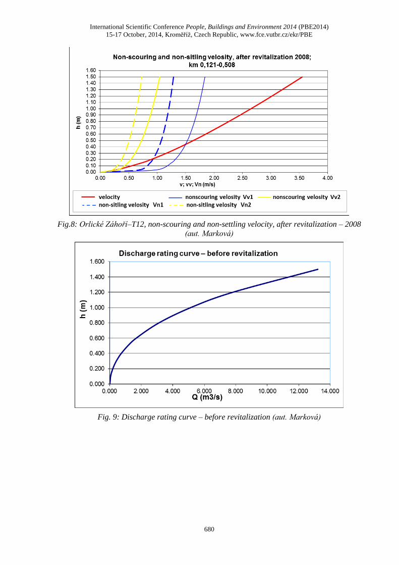
4.5 Measuring curves and non-eroding speeds
Capacity channel after revitalization stays at about 4.5 m3, approximately Q5 despite changes
occurring in the transverse profile occurs.
According to the results of calculations Bran finisher and nonscouring speed is evident that
the trough is rather unstable and is here to erosion. The flow rate Qa - long-term average flow,
but the results of calculations indicate clogging in the channel. Results in 2008 show that due
to changes in bottom paving the trough becomes more stable. Development speed in the
channel is characterized by Fig. 5-10.
Fig. 5: Discharge rating curve – after revitalization- 2013 (aut. Marková)
Page 9
International Scientific Conference People, Buildings and Environment 2014 (PBE2014)
15-17 October, 2014, Kroměříž, Czech Republic, www.fce.vutbr.cz/ekr/PBE
679
Fig.6: Orlické Záhoří–T12, non-scouring and non-settling velocity, after revitalization – 2013
(aut. Marková)
Fig. 7: Discharge rating curve – after revitalization- 2008 (aut. Marková)
Page 10
International Scientific Conference People, Buildings and Environment 2014 (PBE2014)
15-17 October, 2014, Kroměříž, Czech Republic, www.fce.vutbr.cz/ekr/PBE
680
Fig.8: Orlické Záhoří–T12, non-scouring and non-settling velocity, after revitalization – 2008
(aut. Marková)
Fig. 9: Discharge rating curve – before revitalization (aut. Marková)
Page 11
International Scientific Conference People, Buildings and Environment 2014 (PBE2014)
15-17 October, 2014, Kroměříž, Czech Republic, www.fce.vutbr.cz/ekr/PBE
681
Fig.10: Orlické Záhoří–T12, non-scouring and non-settling velocity, before revitalization
(aut. Marková)
5 DISCUSSION
The process of revitalization on the Hraniční potok in Orlické Záhoří has been the subject of
interest and research since its beginning in 2004. It was a significant event at that time, as the
revitalization was approached complexly by the project architect with change of directional and
bed slope situation, with the new draft of the cross profile and designing objects with natural
materials to provide stable conditions from the beginning. The process of "building" a new
revitalized stream can somehow give an impression of another "artificial" interference with the
stream. The change of the route and in the shape of the cross profile was very crucial to the
stream and could not be done without the use of heavy equipment and larger building objects
in form of stone chutes that were set in the concrete. The conditions just after realization and
after four years can be assessed as stabilized and close to nature. The research after ten years
showed, however, some changes in the streambed. The streambed is definitely in the state close
to nature should we compare it with the streambed over the revitalized section that has not been
forcibly ameliorated in the past.
It is often questionable whether by revitalization we want to leave the stream to the state of
nature and self-naturalisation or if the revitalization is supported by a sensitive technical
solution [16]. The revitalization implemented should be able to resist the destructive influences
at least during the period of its effect on the surrounding (creation of sward, implementation of
supportive and riparian vegetation, setting of the created objects). Especially in the presence of
flood flows. Creating objects in the evaluation of revitalization quite fit into natural channel
somehow disrupt its natural character.
Revitalization, which are made only in the form of earthworks, often after passing the higher
flow immediately after the implementation succumb to destruction and may be re-recess
channel, erosion of the material and the devaluation of the event.[6]
Page 12
International Scientific Conference People, Buildings and Environment 2014 (PBE2014)
15-17 October, 2014, Kroměříž, Czech Republic, www.fce.vutbr.cz/ekr/PBE
682
6 CONCLUSION
On the monitored stream the process of stream naturalisation and revitalization was started up.
A living organism became out of the prismatic streambed without significant recovery fitting
into the surrounding natural landscape CHKO Orlické Hory. On the whole it was evaluated
that the setting of the sediments in the streambed is ongoing and the islands with overgrowing
vegetation are forming. There is no obvious bank erosion in the streambed and deeper pools are
created. Calculation of the stability of bed is highly dependent on the method of assessment and
the choice of patterns. Bottom pavement got stabilized in form of coarse material in the
streambed, fine materials form the island and gradually overgrow with vegetation. The objects
are in good conditions and stone chutes and timber reefs do not visually show any signs of
damage. Trough after revitalization still observes the capacity for Q5.Geotextiles used to
overlap the spillover edges of the reefs and grades serve to catch not only the small aquatic
fauna but also the flora. The state of the wooden construction is submitted to a detailed research
in the laboratories of Faculty of Forestry and Wood Technology. The results will be published
after the completion of the experiment.
Planted vegetation around the stream is in poor conditions. The vegetation shows the signs of
damage of gnawing by wild animals and also damage caused by heavy snow. Locally the
reduction intervention probably occurred due to the declared bird area.
REFERENCES
[1] Šlezingr, M., Foltýnová, L., Šulc, V., (2011). The design procedure for pre-grown stabilization
reinforced grass carpet. Acta Univ. Agric. et Silv. Mendel. Brun. 59(6), pp. 355–358, ISSN 1211-
8516.
[2] Šíbl, J. akol. (2002). Revitalizácia vodných tokov,Nitra: SPU, 2002. 240 p. ISBBN 80-8069-024-
3.
[3] Vrána, K., Dostál, T., Gergel, J., Kender, J., Zuna, J. (2004). Revitalizace malých vodních toků –
součást péče o krajinu. Consult, MŢP, Praha, 60 s. ISBN 80-902132-9-4.
[4] Just, T., et al. (2003). Revitalizace vodního prostředí. Agentura ochrany přírody a krajiny ČR,
Praha, 144 p. ISBN 80-86064-72-7.
[5] Králová, H. (2001). Řeky pro život: Revitalizace řek a péče o nivní biotopy. Veronica, Brno, 440 P.
ISBN 80-238-8939-7.
[6] Zuna, J., (1999). Vliv úprav toků a revitalizací potočních koryt a niv na odtok velkých vod.
Krajinotvorné programy 1999. Praha: EnviTypo, 38–41.
[7] Kratochvil, S., (1984). Úpravy toků a zakládání nádrží. Kolektiv autorů, Inženýrská výstavba a
voda v zemědělských soustavách, díl III., Ediční středisko VŠZ v Brně, Brno, 63 – 104.
[8] Tlapák, V., Šálek, J., Legát, v. (1992). Voda v zemědělské krajině. Zemědělské nakladatelství
Brázda, Praha, 320 p.
[9] Ehrlich, P., Gergel, J., ZUNA, J., Novák, L., Meruňka, K. (1996). Metodické pokyny pro
revitalizaci potoků. Metodika 20, Výzkumný ústav meliorací a ochrany půdy, Praha, 70 p.
[10] Just, T. et al. (2005). Vodohospodářské revitalizace a jejich uplatnění v ochraně před povodněmi.
ZO ČSOP, MŢP, AOPK ČR, Praha 2005. 359 p. ISBN 80-239-6351-1.
[11] AGROPROJEKT (1986). Odvodnění pozemků Orlické Záhoří III. Projektová dokumentace, Závod
Pardubice.
[12] Mareš, J. (2001). Revitalizace toku T12 – Orlické záhoří, Projektová dokumentace, Bolehošť,
nestránkováno.
Page 13
International Scientific Conference People, Buildings and Environment 2014 (PBE2014)
15-17 October, 2014, Kroměříž, Czech Republic, www.fce.vutbr.cz/ekr/PBE
683
[13] ČSN EN 933-1 Zkoušení geometrických vlastností kameniva
[14] Mareš, K. (1997). Úpravy toků (Navrhování koryt), Praha: ČVUT Praha. 210 s.
[15] Ondrejka Harbulakova, Vlasta, Zelenakova, Martina. (2013). Technical measures of riverbank
stabilization in engineering practice, 2013. In: Visnik : Teoria i praktika budovnictva. 756, pp. 200-
206. - ISSN 0321-0499
[16] Gergel, J., Erlich, P. (1999). Možnosti hodnocení účinnosti revitalizace drobných vodních toků.
Krajinotvorné programy 1999, Praha: EnviTypo, pp. 55–57.