HARYANA GOVT. GAZ. (EXTRA.), JAN. 7, 2013 (PAUS 17, 1934 SAKA) HARYANA GOVERNMENT TOWN AND COUNTRY PLANNING DEPARTMENT NOTIFICATION The 7 th January, 2013 No. CCP (NCR)/RTK/DDP-2031/2013/69 .– In exercise of the powers conferred by sub-section (4) of section 5 of the Punjab Scheduled Roads and Controlled Areas Restriction of Unregulated Development Act, 1963 (Punjab Act 41 of 1963), and in supersession of all other notifications issued in this behalf from time to time, the Governor of Haryana hereby publishes the following Draft Development Plan 2031 AD for Rohtak along with restrictions and conditions as given in Annexure A and B proposed to be made applicable to the controlled areas specified in Annexure B. Notice is hereby given that the Draft Development Plan-2031 AD shall be taken into consideration by the Government on or after the expiry of a period of thirty days from the date of publication of this notification in the Official Gazette together with objections or suggestions if any, which may be received by the Director, Town and Country Planning Department, Haryana, Aayojna Bhawan, Sector –18, Chandigarh, from any person in writing in respect of such plan before the expiry of the period so specified. DRAWINGS (a) Existing Land use Plan Drawing No. RTP ( N.C.R.) 245/71, dated the 7 th October, 1971. (b) Existing Land Use Plan Drawing No. DTP ( R ) 1364/97,dated the 21 st February, 1997 for Additional Controlled Area. [(a) and (b) already published vide Haryana Government, Town and Country Planning Department, Notification No. R-CA / 97/ 1149 dated the 26 th August, 1997]. (c) Existing Land Use Plan Drawing No. DTP ( R ) 1610 – A /06 ,dated the 6 th June, 2006 for Additional Controlled Area II. (d) Existing Land Use Plan Drawing No. DTP ( R ) 1610 – B /06 ,dated the 19 th June, 2006 for Controlled Area around Dada Chavan Rishi Temple at village Kahrawar (e) Existing Land Use Plan Drawing No. DTP ( R )1610 – C /06,dated the 19 th June, 2006 for Controlled Area around Radha Krishna Mandir, Chulana Mor, village Ismaila ( 9 Biswa) . (f) Existing Land Use Plan Drawing No. DTP (R) 222/07,dated the 9 th April, 2007 for Additional Controlled Area III around Municipal Council Limit Rohtak covering revenue estate of Village Bhambhewa, District Jhajjar. [(c) to (f) above already published – vide Haryana Government, Town and Country Planning Department, notification No. C.C.P. (N.C.R.) R.D.D.P.( RTK) / 2007/ 3296 dated 18.9.2007]. (g) Existing Land Use Plan Drawing No. DTP (R) 1792/10 dated the 22 nd June, 2010 for Additional Controlled Area (near village-Bhalauth) Rohtak. (h) Draft Development plan 2031 A.D. for Rohtak Controlled Areas bearing Drawing No. DTP(R) 1763/09 dated 25.11.2009 / 22.6.2012. Annexure ‘A’ Explanatory note on the Draft Development Plan 2031 A.D. around controlled areas of Rohtak 1. INTRODUCTION :
No. CCP (NCR)/RTK/DDP-2031/2013/69 .– In exercise of the powers conferred by sub-section (4) of section 5 of the Punjab Scheduled Roads and Controlled Areas Restriction of Unregulated Development Act, 1963 (Punjab Act 41 of 1963), and in supersession of all other notifications issued in this behalf from time to time, the Governor of Haryana hereby publishes the following Draft Development Plan 2031 AD for Rohtak along with restrictions and conditions as given in Annexure A and B proposed to be made applicable to the controlled areas specified in Annexure B. Notice is hereby given that the Draft Development Plan-2031 AD shall be taken into consideration by the Government on or after the expiry of a period of thirty days from the date of publication of this notification in the Official Gazette together with objections or suggestions if any, which may be received by the Director, Town and Country Planning Department, Haryana, Aayojna Bhawan, Sector –18, Chandigarh, from any person in writing in respect of such plan before the expiry of the period so specified.
DRAWINGS (a) Existing Land use Plan Drawing No. RTP ( N.C.R.) 245/71, dated the 7th October, 1971. (b) Existing Land Use Plan Drawing No. DTP ( R ) 1364/97,dated the 21st February, 1997 for
Additional Controlled Area. [(a) and (b) already published vide Haryana Government, Town and Country Planning Department, Notification No. R-CA / 97/ 1149 dated the 26th August, 1997].
(c) Existing Land Use Plan Drawing No. DTP ( R ) 1610 – A /06 ,dated the 6th June, 2006 for Additional Controlled Area II.
(d) Existing Land Use Plan Drawing No. DTP ( R ) 1610 – B /06 ,dated the 19th June, 2006 for Controlled Area around Dada Chavan Rishi Temple at village Kahrawar
(e) Existing Land Use Plan Drawing No. DTP ( R )1610 – C /06,dated the 19th June, 2006 for Controlled Area around Radha Krishna Mandir, Chulana Mor, village Ismaila ( 9 Biswa) .
(f) Existing Land Use Plan Drawing No. DTP (R) 222/07,dated the 9th April, 2007 for Additional Controlled Area III around Municipal Council Limit Rohtak covering revenue estate of Village Bhambhewa, District Jhajjar. [(c) to (f) above already published – vide Haryana Government, Town and Country Planning Department, notification No. C.C.P. (N.C.R.) R.D.D.P.( RTK) / 2007/ 3296 dated 18.9.2007].
(g) Existing Land Use Plan Drawing No. DTP (R) 1792/10 dated the 22nd June, 2010 for Additional Controlled Area (near village-Bhalauth) Rohtak.
(h) Draft Development plan 2031 A.D. for Rohtak Controlled Areas bearing Drawing No. DTP(R) 1763/09 dated 25.11.2009 / 22.6.2012.
Annexure ‘A’
Explanatory note on the Draft Development Plan 2031 A.D. around controlled areas of Rohtak
Rohtak Town lies at a distance of 75 kilometer from Delhi towards its north – west on National Highway No. 9 (Delhi-Hisar-Sulemanki Road). Delhi being a Metropolis in whole of Northern Region extends its influence on areas, falling on its outskirts of Uttar Pradesh, Rajasthan and Haryana. As such the Town and Country Planning Organization, Government of India prepared a National Capital Region Plan in consultation with the planning departments of adjoining States. Subsequently National Capital Region Planning Board was formulated in 1985 in order to provide balanced development of these regions. Accordingly, the National Capital Region Plan 2001 was prepared by the National Capital Region Planning Board in consultation with the State Governments.
Rohtak town is one of the eight Priority Towns (Regional Centers) of National
Capital Region, with assigned population of 5 lac by 2001 AD against population of 1.66 lac in 1981 and its gross density has been proposed 110 persons per hectare up to 5 lac population Regional Plan 2001. According to 1991 census, its population was 2.15 lac. Keeping in view, the policies of State Government as well as the increasing demand of land due to employment potentials and commercial base, the Revised Final Development Plan was published in the year 1998 for a population of 7 lac by 2031 AD for both the Controlled Areas, with gross density of 110 persons per hectare. This low density has been kept for providing more sectors for development towards Delhi side keeping in view the contemporary trend of growth.
The strategy for development of the settlement system, as per NCR Regional plan 2021, allows other towns of the NCR to develop within their carrying capacity and development potential, as may be determined by the Development / Planning Agencies of the constituent States of the NCR. The said Regional Plan identifies Rohtak Town as one of the Regional Centre with population ranging from 3 lac to 10 lac. The Regional Centre is well – established urban centre and one among the highest order settlement of six-tier hierarchy settlements, after the Metro Centers in the NCR. The Regional Centre performs highly specialized secondary and tertiary sector activities for providing job opportunities, which cannot be provided by the lower order Centre. These centres, according to the NCR Plan, will be developed for advanced industrial and other economic activities and will have concentration of administrative and higher order service functions, which are expected to exert an increasingly dynamic influence on attraction of investment of conducive living and working environment. The NCR Plan assigned population of 4.44 lac by 2011 AD and 5.84 lac by 2021 AD against population of 2.94 lac in 2001 AD for this Regional Centre. The gross density proposed is 125 to 150 persons per hectare for 5 to 10 lac population in urban centres. 2. EXISTING PHYSICAL FEATURES: Delhi- Hisar Road passes through the town, thus the shape of the town has emerged into a linear form due to developments along the National Highway. The only bye-pass on Delhi-Hissar-Sulemanki Road is towards its north and is bisected by the intercity roads to Sonipat, Gohana and Jind. On eastern side of the town flows a distributory in the name of Bhalaut sub-branch. It is also acting as a source of water supply to the town. The drain No. 8 runs on the western side of the town and is a useful source for protecting the town from floods from that side.
On the north - western side of the town, there is an undulating area of about 200 hectare
known as old Rohtas Garh (Vanished with the time and buried over here). This area has been reserved by the Archeology Department, Government of India for Archeological findings. The heart of the town is of bowl shape. Besides this, there are other pockets where discharge of storm water through gravity is not possible and as such pumping system is the only remedial measure.
The ground water being brackish, the water supply is canal based. There are two water works, one along Sonipat road and other along Jhajjar Road.
There are a number of drains on the northern side of the town, which have been creating flooding problems from time to time because of general slope being from North to South.
3. EXISTING IMPORTANT FACILITIES: The town is enjoying a nodal location due to the following consideration: -
1. Rohtak town besides being District Headquarter is also functioning as Head Quarter of Divisional Commissioner and Inspector- General Police. There is a Court Complex, Central Excise and Customs office, Income Tax Circle office. Thus it accommodates a large number of Government Offices.
2. The town is well connected through a network of broad gauge Northern Railway linking National Capital Delhi, Haryana state Bhiwani-Hisar-Sirsa towards west, Panipat –Ambala- Chandigarh towards north and Jind-Narwana on the north-west side. The road linkages are through NH-09, NH-52 and NH-709 in addition to Bhiwani, Sonipat through scheduled roads. It has a large grain market, vegetable market, Fodder Market; it also commands a position in cloth merchandise in the region and a sweet namely „Rewari‟.
3. It has privilege of having the only Post – Graduate Institute of Medical Science in the state besides Maharishi Dayanand University and Baba Mast Nath College. There are two Ayurvedic Colleges, eight degree colleges, five Engineering College, three Women College, two Polytechnics besides Indian Institute of management and other educational institutions like kendriya vidyalaya. It will now have a fashion design institute, a State Institute of Film and TV, a fine art college and an Urban Planning and Architecture College.
4. It enjoys the pride position for having an All India Radio Station of Haryana. 5. It has two tourist Complexes namely, Tilyar and Myna. The Tilyar Complex being located
on Delhi – Hisar – Sulemanki road in a spacious area, having a zoo and lake, has become a centre of interest for the town and its surrounding areas as well as for tourists and business entrepreneurs. The Myna Tourist Complex is located in Rohtak city from 74 kms from Delhi in the area of 4 acres.
6. It has a large scale industrial unit i.e. sugar mill as an agro based unit promoting sugarcane cultivation in the region. The industrial sector, industrial Development Colony (IDC), houses Laxmi Precision Screws (LPS) and number of ancillary units; Milk product unit under the nomenclature VITA exists on Gohana road.
7. It has a bus terminus, railway station, Jail complex, police line, Food Corporation of India
(FCI) Godowns and three stadiums.
4. NECESSITY FOR THE AMENDMENT OF THE DRAFT DEVELOPMENT PLAN : The first Development Plan (Final Development Plan) was published vide Haryana Government, Town and Country Planning Department, Notification No. 1331 – 10 DP – 82 / 4789, dated the 26th March, 1982 published in Haryana Government Gazette dated the 18th May, 1982. Subsequently, Revised Development Plan was notified vide Haryana Government, Town and Country Planning Department, notification No., No. CCP (NCR) R-C.A./98/1464 dated the 3rd September, 1998 and published in the Haryana Govt. Gazette. (Extra) on 8th September, 1998. Although the location of the town provides great potentials for industrial development through induced growth, the town has only limited industrial units resulting in a weak economic base. As such the development of the town has not taken place to the desired extent, keeping pace with the envisaged population of 5 lac by 2001 as per the Regional Plan. That is why the town has not come on the industrial map of the state.
Keeping in view, the new industrial policy, 2011 of Government of Haryana, locational
advantages, development of Kundli- Manesar- Palwal (KMP) Western Periphery Expressway in the close vicinity (approximately 25 kilometer away) towards east to this NCR Regional centre, nearness to India‟s biggest metropolis has lead to the setting up of Industrial Model Township (IMT) and rapid industrial development in this heartland of Haryana. The Haryana Government has agreed to extend the existing IMT area further towards eastern side of the Eastern Bye-pass. In
addition to above, due to Planning of the Rohtak- Hansi Railway link for direct connectivity to Hisar, a Counter Magnet Town of NCR, Railway link to Jhajjar and Rewari as Regional rail Network, four laning of Rohtak- Bahadurgarh NH-9 as well as NH-52. The grid roads from Rohtak- Jhajjar and Rohtak-Sonipat have increased job opportunity, connectivity and demand of land. Therefore, the amendments of the Development Plan are quite essential for following consideration:-
(a) Induced Industrial Growth:- The location of this town being almost in the middle of Delhi
and Hisar (a counter – magnet town of National Capital Region) where land values are high, increase in pressure due to availability of unique educational and medical facilities will continue but infrastructure is inadequate.
(b) Induced Economic Activities:- Keeping in view the possibilities of a large number of
industries, National and State Highways, educational institutions, medical facilities of higher order administrative setup, there is necessity of setting up a Transport Nagar and other infrastructure like wholesale markets, housing and city centre, besides working provision for shifting of offices/ public sector undertakings out of Delhi.
(c) Additional Recreational Facilities: - In addition to the existing spacious Tilyar Complex
there is still necessity for provision of additional areas for various activities like leisure parks ,existing large stretches of agriculture farms open avenues for agro-tourism.
(d) Necessity for Railway Line between Rohtak and Rewari and between Rohtak and Hisar:- As
per National Capital Region Plan proposal, provision of Rohtak – Rewari railway line via Jhajjar has been made in the plan. In order to link Hisar (Counter Magnet Town) with Delhi, a railway line from Rohtak to Hisar via Hansi is essential and as such provision for the same has been made in the project by taking linkage from the existing Bhiwani railway line, subject to the approval from Railway Board.
(e) Necessity for Northern Bye-pass and Southern Bye-pass:- Keeping in view the proposed
extended urbanisable limits, the existing northern bye-pass published in the Final Development Plan was converted into ordinary sector road. Instead the northern bye – pass has been proposed. To cope up with the problem of traffic congestion and traffic bottlenecks the proposed northern and southern bye – passes are the need of the hour.
(f) Construction of Rohtak Drain:- For proper disposal of storm water of Haryana Urban Development Authority sectors and town area, there is necessity to link Bohar Drain with Kultana- Chhudani- Bupania Drain (KCB Drain) under the scheme of Rohtak Drain.
(g) Provision of Bridges for proper Communication and Transportation:- For smooth flow of
the traffic between the various components of the existing and proposed town and to provide unhindered traffic on the bye-pass, peripheral roads, and provisions of rail over bridges, in phased manner are essential.
(h) Omission of Air Strip Site:- Due to the extension of urbanisable area towards northern side
of the town from the view point of protection from floods, site for air strip has been omitted and will be provided in the rural zone as per requirements and site conditions as and when received from Director General, Ministry of Civil Aviation, New Delhi.
(i) Four Laning of National Highway and Grid Roads:- Four laning / Up grading of National
Highway No. 9, 52 and 709 has been proposed in this plan. As per National Capital Region Plan, four laning of Bahadurgarh- Rohtak segment and Rohtak section on National
Highway 52 is to be completed. Rohtak –Sonipat and Rohtak –Jhajjar, Rohtak- Jind, Rohtak- Bhiwani, Grid Roads are to be completed.
(j) Additional Controlled Areas:- To prevent haphazard and sub–standard development
around this regional centre of the NCR Controlled areas have been declared vide Haryana Government, Town and Country Planning Department, Haryana, notification No 4587-V DP-69/3719, dated the 11th June, 1969, published in Haryana Government Gazette, dated the 8th July, 1969 around the Municipal Council Limit under section 4-(1) (a) of the Punjab Scheduled Roads and Controlled Areas Restriction of Unregulated Development Act, 1963. Additional Controlled Area was declared vide Haryana Government, Town and Country Planning Department, notification No. 1107/ CCP (NCR)/96, dated 11th October, 1996 published in Haryana Government Gazette, dated the 5th November 1996 around the Municipal Council limit under section 4-(1) (a) of the Punjab Scheduled Roads and Controlled Areas Restriction of Unregulated Development Act, 1963. Additional Controlled Area II Rohtak have been declared under section 4- (1) (a) of the Punjab Scheduled Roads and Controlled Areas Restriction of Unregulated Development Act, 1963 vide Haryana Government, Town and Country Planning Department, notification No CCP ( NCR) / RTK (ACA-II)/A/2006/1082 dated the 4th May, 2006 (Extra.) published in Government Gazette on 4th May, 2006 and Controlled Area around Dada Chavan Rishi Temple at village Kharawar under section 4-(1) (b) of the Punjab Scheduled Roads and Controlled Areas Restriction of Unregulated Development Act, 1963 declared vide Haryana Government, Town and Country Planning Department, notification No. CCP (NCR) NH10/RTK/5/C.A./B/ 2006/1380 dated 13th June, 2006, published in Haryana Government Gazette (Extra.), dated the 13th June, 2006. The Controlled Area around Radha Krishana Mandir, Chuliana Mor, village Ismaila (9 Biswa) has been declared under section 4-(1) (b) of the Punjab Scheduled Roads and Controlled Areas Restriction of Unregulated Development Act, 1963 declared vide Haryana Government, Town and Country Planning Department, notification No. CCP (NCR) NH10/RTK/5/C.A./B/ 2006/1381 dated 13th June, 2006, Published in Haryana Government Gazette ( Extra.), dated the 13th June, 2006. The Additional Controlled Area III around Municipal Council Limit Rohtak covering revenue estate of Village Bhambhewa, District Jhajjar has been declared under section 4-(1) (a) of the Punjab Scheduled Roads and Controlled Areas Restriction of Unregulated Development Act, 1963 declared vide Haryana Government, Town and Country Planning Department, notification No. CCP (NCR) /RTK(A.C.A III.) / A / 2007/1366 dated March 28, 2007, Published in Haryana Government Gazette ( Extra.), dated the 28th March, 2007. The Additional Controlled Area has been declared vide Haryana Government, Town and Country Planning Department, notification No. CCP (NCR)RTK-BHLT/ACA/2010/1774, dated 18th May, 2010 published in Haryana Government Gazette, dated the 18th May 2010 around the Municipal Council limit under section 4-(1) of the Punjab Scheduled Roads and Controlled Areas Restriction of Unregulated Development Act,1963.
Keeping the above factors in view, the Revised Draft Development Plan was published on dated 18th September 2007, prepared for the existing controlled area as well as the Additional Controlled Areas II Rohtak ,Controlled Area around Dada Chavan Rishi Temple at village Kahrawar and Controlled Area around Radha Krishna Mandir, Chulana Mor, village Ismaila (9 Biswa) and Additional Controlled Areas III around M.C. Rohtak covering revenue estate of Village Bhambhewa, District Jhajjar.
However, the decision of the Government to expand the existing Industrial Model Township Rohtak further towards the eastern side resulted in the modification of the Draft Development Plan Rohtak 2031 A.D.
5. POPULATION PROJECTION:-
Table 1 : Decade-wise and projected growth of population
Year Population Growth rate (in Population of settlements in urbanisable
2011 477877 25.13 373133 (M Con) + 104744 villages (87312 x 20%) as District Rohtak growth rate] = 477877
2021* 764603 60.00 * Projected
2031* 1299825(13 lacs)
70.00 * Projected
The population of settlements covered in the urbanisable limit in this proposed Draft
Development Plan -2031 as per census 2001 is 3, 81,889 person (Baliana 7151, Bohar 12807, Dobh 3323, Garhi Bohar 3584, Kheri Sadh 4415, Kahrawar 28155, Sunari Kalan 14073,Sunari Khurd-2928, Kanheli 1747, Maina 4257,Pahrawar 3203,). Population of Rohtak Municipal Council was 294577 where out growth as sector was 7770, excluding population of Rohtak (Rural) as 1668 persons. The Municipal Council area Rohtak has been increased in year 2007.
With coming up of the Kundli- Manesar- Palwal (KMP) Western Periphery Expressway in the close vicinity (approximately 25 Kilometres away) towards east to this NCR Regional centre, nearness to India‟s biggest metropolis, Planning of the Rohtak- Hansi Railway link for direct connectivity to the Hisar, a Counter Magnet Town of NCR, Railway link to Jhajjar and Rewari as Regional Rail Network, Four laning of Rohtak- Bahadurgarh National -Highway 9 as well as National Highway No- 52. The Grid Roads from Rohtak- Jhajjar and Rohtak-Sonipat The pace of development now observed in Rohtak city in view of the above factors and the development of the southern bye-pass, development projects started in the town for construction of road over bridges, rail over bridges, development of transport nagar and auto market, widening of roads, augmentation of water supply, effective measures of flood control, efforts of solid waste management, improvement of infrastructure in the educational, health-care and sports institutions is not only attracting the private sector in the urban land development but is generating an atmosphere of development towards Delhi as well as southern side of the town. It has led to the setting up of Industrial Model Township (IMT) and rapid industrial development in this heartland of Haryana. This will help in increase of job opportunities, connectivity and demand for land.
6. DEVELOPMENT PROPOSALS:
The Draft Development Plan 2025 A.D. Rohtak was published for a projected population of 9.43 lacs by 2025 AD and now the Draft Development Plan Rohtak 2031 has been prepared for 13.00 lacs person by 2031 AD, which will be implemented in a phased manner. The existing town and villages in the urbanisable area covers total area of about 1268 hectares and it will accommodate a population of about 3,20,000 persons. The planning in this area is conspicuously absent and it is thickly populated.
The residential density proposed is 250 persons per hectare whereas the proposed gross
density of Rohtak is 89 persons per hectare. Total 77 sectors have been proposed in the Development Plan. The extent of various land uses is given below: -
Existing area of the town 883.39 hectares Existing area of the villages in Urbanisable limit 384.55 hectares Total urbanisable area 13364.06 + 883.39 + 384.55 = 14632 Hectares
RESIDENTIAL:- To provide for the projected population an area of 3849.64 hectares has been proposed in sectors 1,2,3,4,5, 6 Part, 7 part, 9,10,14, 19, 20-A, 20- B, 21-A part, 21-B Part, 21-C, 21-D ,21-E, 22, 22A, 22B, 22 D, 23, 24 Part, 25 Part, 25 -D, 26 part, 26A, 27, 27A, 27-C Part, 27-D, 28, 33, 33-A, 34 part, 35, 36, 36-A, 37, 38 part, 39 part and 40 part for residential use in addition to the existing town area. The average density of the residential sectors work out to about 250 persons per hectare. Sector 27C, 27D has been reserved for labour housing with 300 persons per hectare density. Group Housing in these sectors is proposed to be developed with a residential density of 600 persons per acre. The public utility site in sector-39 on Jind road has now been earmarked for residential development for low income housing with density of 600 persons per acre. The Dairy complex situated in Sector 24 has been incorporated in the plan.
The Government vide its order dated 26.8.09 approved the following provisions to be incorporated in the Development Plan vide increasing their density:- (1) The additional area for infrastructure shall be provided in the already planned /
developed residential sectors to meet out the requirement of the additional population. (2) The minimum width of the roads in a residential colony / sector shall not be less than
12 metres. (3) The minimum area for parks /open spaces in a residential colony/ sectors shall be
planned in such a manner that it shall meet the minimum norm of 2.5 sq. metres per person.
COMMERCIAL :- An area of about 543.13 hectares has been proposed in sector 18-A, 20, 21A Part, 30, 31-A, 40 Part for commercial use. A city centre has been proposed in sector 30 and 31A abutting National Highway-9. A building material market has been proposed in sector 21 (special zone) whereas an auto market and auto workshops in sector 18, 18A. A grain market exists in sector 18 A. In sector 38 and 39, a 400 metres wide commercial belt has been provided for restaurants, hotels, transit boarding houses, institutions providing residential accommodation like dharamshala, tourist complex etc, cinema and other places of public assembly. An Agro Mall is being developed by Haryana State Agriculture Marketing Board in sector 14. Few commercial belts of 150 metres have also been provided in sectors 21-E, 21-D, 22-D, 25-C, 26, 27-C and opposite to sector 7, 8, 20, 37, along development plan roads where as 100 metres belt in sector 6, 28, 37 and 70 metres wide belts have been proposed in sector 34 and 35. The requirement of land for Commercial activities in Industrial Model Township shall be provided in the Industrial Model Township itself by the developing agency.
The industrial sectors of 1982.9 hectares have been proposed towards east and west of the town. New industrial sectors have been proposed towards east for setting up of Industrial Model Township ( IMT) north to National Highway 9 viz. Sector no. 30-A, 30-B, 30-C, 30-D, 30-E 30-F 31-B, 31-D, 33-B and 33-C. Site for sugar mill as selected by the high powered committee has been incorporated in the plan on Bhiwani road. Keeping pace with the policies of the National Capital Region to develop Rohtak as Regional Centre and for balanced development of the region, it is essential to provide sound economic base for the town through Industrial activities by means of induced growth, setting up Industrial Model Township, oil and food grain–based agro-industrial units, a large scale mother industrial unit in addition to the Automobile industry, in view of the location of town on junction of National Highway 9, 52 and 709 in Rohtak as it has enormous potential of industrial development. Maruti Udyog, Asian Paints, Footwear Design and Development Institute etc are coming up within this industrial area. Sector 20 is an industrial area developed by industries department.
TRANSPORT AND COMMUNICATION:-
An area of 2198.64 hectares (Including roads) has been proposed in the Draft Development Plan for Transport and Communication. Keeping in view the trend of expansion of urbanisable areas towards south and in east viz.-a viz land use in vicinity to Rohtak and Asthal Bohar railway station as well as to the grain, fodder and vegetable market and to the National Highway 52 bye- pass towards south, Sector 18 part, 25-A, 25-B and 25-C as well as site in sector 6, 26, near to new sugar mill site and on National Highway-52 have been provided. A Transport Nagar has been proposed near Asthal Bohar railway station. An auto market and auto repairing sites have been proposed in sector 18 and 18A in the Draft Development Plan. The new bus stand already exists in sector-6.
Sector 25-A, 25-B and Sector 25-C has been proposed near railway station for railway siding, loading unloading platforms, yard, inland container depot, weigh bridges, FCI Godowns, Fuel storage, pipe lines, storage of heavy building material .
Bye pass around the town has been provided with road reservation of 75 metres with 100 metres wide green belt on both sides as V-I road where as Bye pass for village Kheri Sadh (On National High way- 10) and Village Dobh (on Bhiwani Road) with road reservation of 60 metres with 100mts green belt on both the sides as V-IA road has been proposed. Widening of the earlier 45 metre roads has been made as V2 road with 60 metre width having 30 metres green belts and all the 30 metres sector dividing roads, which have not yet been developed have been proposed for 45 metres width considering the future traffic on Sonipat and Bhiwani road, due to the provisions of the major industrial land uses, the road reservation of these roads has been kept as 60 metres with 30mts green belt as V -2 B road. For streamlining the traffic between the various components of the existing and proposed town and to provide un – hindered traffic on the bye – pass, circular roads , provisions of rail over bridges , in phased manner, has been proposed on Jhajjar road, Delhi road, Double Fatak Junction, Southern bye pass crossing Rohtak-Delhi segment, Southern bye pass crossing Rohtak-Bhiwani and proposed Hisar segment, northern bye pass crossing Rohtak-Gohana segment, Western circular road crossing Rohtak-Jind segment, Bhiwani Rohtak Road, Kattcha Beri road etc. In addition flyovers are proposed for the smooth flow of traffic at Sheela bye pass (Sonipat road), Southern bye pass crossing Rohtak-Jhajjar National Highway 71, Southern bye pass crossing Rohtak-Bhiwani scheduled road, Sonipat road near sector 2, Gohana road –Bye pass, Sonipat road – Bye pass etc. 7 No. of clover leaf junctions have been proposed on V-1 road.
The requirement of transport and communication area for Industrial Model Township shall be provided in the Industrial Model Township area itself by the developing agency.
The hierarchy of roads proposed, in this plan will be as under:-
75 Metre wide with 100 Metre Green Belt on both the sides.
2. V -I A Bye pass ( Village) 60 Metre wide with 100 Metre Green Belt on both the sides.
3. V -I C National Highway 60 Metre wide with 60 Metre Green Belt on both the sides.
4. V- 2 Major Road 60 Metre widened from earlier 45 Metre width with 30 Metre green belt on both sides.
5. V -2 AA Part of NH-9 from Bye pass junction to sector 29-30 junction
60 Metre wide with 150 Metre green belt on both sides (excluding the already licenced area of sector 27 and unacquired area of sector 27A, 27B, 30, 30A and 30 B where 30 Metre green belt kept).
6. V -2 AB Part of NH-9 from sector 29-30 junction to JLN canal
60 Metre wide with 50 meter green belt on both sides.
7. V- 2 A Sector Dividing Road 45 Metre widened from earlier 30 Meter width where such roads have not been constructed/plan implemented.
8. V- 2 B Major Road (Bhiwani and Sonipat Scheduled Road)
60 Metre wide with 30 Metre green belt on both sides.
9. V-2B-I Outer road of proposed IMT 60 Metre wide with 100 Metre green belt only on outer side.
10. V -3 Sector Dividing Road and road between 1-2 and 3-4
30 Meter (Earlier 30 Meter such roads which has been constructed/plan implemented).
Approach to the Asthal Bohar railway station (near sector 26) has been made with
supporting land uses to avoid traffic congestion in old Town to provide facility to the residents of this entire newly planned area. Since Rohtak town has developed in a linear pattern along the National Highway 9 hence it does not have proper connectivity between areas across railway line. A 45-meter wide road has been proposed through Maharishi Dayanand University near Jawaharlal Nehru (JLN) Canal having access from Sector-28 and linking National Highway-52 through Sector 24-25 dividing road with Railway Over Bridge on Delhi- Rohtak Railway segment. For High Speed Tramway system a strip of land along the Rohtak – Delhi railway line is reserved on northern side in this plan. PUBLIC UTILITIES:- An area of about 647.55 hectares has been provided for public utility service like water supply, grid sub- station, and disposal works etc. in different sectors. Sites of the earlier plan have been accommodated in this plan viz Sectors 1, 2, 7, 23, 25 and 34. Sector 22C has been reserved for public utility purposes. Sites being developed by the public health Department for Disposal works near village Singhpura Kalan and in Sector 21-B near Drain No.8 have been incorporated in the Development plan. Additional sites in sector 15, 20, 20-B, 21B, 22C, 25-A, 26, 27-C, 37, 38 and opposite to sector 37 and 33 as well as sites near southern bye pass (village Simli), between JLN and Sonipat road, Jind Road and opposite to sector 20 have been proposed for their balanced spatial distribution, from operational and economic considerations, to cope with the demands from time to time in addition to the existing water services. For solid waste disposal an area of about 20 hectares has been proposed along drain No.8 in sector 21-B. The requirement of
public utility sites for Industrial Model Township, in addition to land reserved towards north east of sector 33 on Sonipat road, shall be provided in the Industrial Model Township area itself by the developing agency. PUBLIC AND SEMI - PUBLIC USES:- The Draft Development Plan envisages Rohtak as an Educational Hub. Sector 26 B, 27B have been reserved for institutional purpose between National Highway 9 and Delhi- Rohtak railway segment. An area of 1465.5 hectares has been proposed for this use in sector 5 part, 6 part, 7 part, 21B, 25-A, 27-D, 29 and 31 in addition to 150 metres wide strips in sector 20- B, 21-C, 21-E, 22A, 25-D, 39. The 70 metres wide strip for public and semi-public uses has been provided in sector 36 and 36A. Sufficient vacant pockets are available in Maharishi Dayanand University and Post Graduate Institute of Medical sciences Campus in sector 15 which could be utilized for Public and Semi Public uses. The town has high potential for higher and technical education hence such institutions have been proposed in sector 26-B , 27-B as proposed educational hub in addition to other institutions and organizations. Provisions of various Police, Jail, Defence and Educational Institutions have been proposed towards Southern Bye-pass for an area of about 590 hectares to facilitate the housing of various institutions. Rohtak is having sites for Indian Institute of management, Maharishi Dayanand University, Post Graduate Institute of Medical Scince, Fashion Design Institute, a State Institute of Film and TV, a Fine Arts College and an Urban Planning and Architecture College. OPEN SPACE:- An area of about 2586.94 hectares have been proposed in the Development Plan in the form of sectors and green belts. Vast open space along National Highway 9 as V-2A road from Bye pass junction to sector 29- 30 junction with 30 meter wide green belt on both sides has been proposed as well as in the vicinity of the proposed educational hub site in Sector 26-B, 27-B. Green belt of 50 metres width along National Highway 9 (V-2 AB road) has been proposed from sector 29 – 30 junction to Jawaharlal Nehru (JLN) Canal. The green belt along V–1 Road and other roads will also come under open spaces. Along V2 road and Drain No.8 a green belt of 30 meter width has been proposed excluding north of sector 2 which has already been developed by Haryana Urban Development Authority. The areas of Tilyar complex, sector–32 to be developed as town park and the areas of Renakpura reserved by Archeology Department are taken in this Zone. Part of sector 28 i.e. land identified by Archeology Department has been kept open space by accommodating provisions of layout plan of earlier licenced colony. A site for sports complex has been provided in sector 6. Green belt of 100 metres width on both the sides of the bye passes has been provided; Green belt of 60 metres width on both the sides of the other National Highways have been provided by widening the width of green belt from 30 metres. Open spaces of different levels have been proposed in the Draft Development Plan. Town level open spaces have been proposed in the western side to sector 8, 38 part, 39 part and 40 part and in sector 25, 25-A and28. Regional level open space has been proposed in Sector 21-B where as regional recreation has been proposed along the southern bye pass in sector 25–E opposite to the educational hub to provide viable recreation space in the surrounding to the Industrial Model Township, Educational Hub and city centre. The green buffer between residential sector and Industrial sectors have also been proposed. The existing Jail Complex has been earmarked to be developed as open space. AGRICULTURAL ZONE:-
A sizeable area has been reserved as agricultural zone. This zone will, however, not eliminate the essential building development within this area, such as the extension of existing village contiguous to abadi – deh undertaken as project approved or sponsored by Government and other ancillary and allied facilities necessary for maintenance and improvement of this area as agriculture land.
An area of 74.76 hectares (app.) has been reserved for special zone, which shall include commercial and residential use in sector 21. CONSERVATION OF HERITAGE SITES:-
The monuments, heritage sites, special areas of aesthetic, sentimental or historic value which require protection shall be protected. PHASING OF DEVELOPMENT PLAN :-
Sr. No.
Period Sectors to be developed Development activities to be taken up
1 2011-2021
Residential sector-4(part),5, 6, 7 (part),21, 21 A,21 B , 21 C, 21 D, 21 E, 24 (part),25(part), 25 D,26, 26 A, 27, 27 A, 27-C, 27D, 28,33, 33- A, 34 Part, 35 (part),36,36 A and 37, 39 (Part) Commercial sector-6, 18 A (part), 21, 21 A (part), 21D,25 C 24 (part), 25(part), 30, 31-A, 34, 35, 37 Institutional sector –5,6, 21C, 25A, 26 B, 27 B , 29, 31, 36, 36 A, 7 (part),. Industrial sector- 20, 30-A, 30-B, 30-C, 30D, 30E, 30F, 31-B, 31 –, 31-D, 33-B, 33-C. Transportation-18, and 25-A (part), 25-B, 25C.Roads and fly overs/ ROBs and clover leaf junctions. Public utility- 1,2,15, 20, , 21 B, 22 C, 25, 25 A, 26, 27 C, opposite to 33, 34, 37, site near Village Simli. Open space-150 mtrs wide green belt along the National Highway No.9 and sports complex in sector 6, sector 32, 25, 25 A, 25 C, 25E. Special Zone in sector 21.
Development activities to be taken up Construction of southern bye-pass and proposed V-2 road of width 60 metres, four laning of the existing NH-9, NH-52, NH-709, Rapid Regional Rail network has proposed in the regional plan for -2021, development of sewer disposal site and construction of over bridges.
2 2021-2031
Rest of the proposals of development plan. Rest of the activities/proposal in the development plan.
Note: The above phasing is tentative and subject to change as per requirements. Zoning Regulations:-
The legal sanctity to the proposals regarding land use is being given effect by a set of zoning regulations, which form a part of this development plan. These regulations will govern the change of land use and standards of development. They also very elaborately detail out allied and ancillary uses which will be permitted in the various major land uses and stipulate that all change of land use and development shall be in accordance with the details shown in the sector plan thereby ensuring the preparation of detailed sector plans for each sector to guide the development and enforce proper control.
ANNEXURE- B
Zoning Regulations: Governing use and development of land in the controlled areas of Rohtak as shown in Draft Development Plan Drawing No. DTP(R) 1763/2009, dated 25th November, 2009/22nd June 2012. I. General:
1. These Zoning Regulations, forming part of the Development Plan for the Controlled Areas around Rohtak, shall be called Zoning Regulations of Draft Development Plan for Controlled Areas Rohtak.
2. The requirement of these regulations shall extend to the whole of the area covered by the
Draft Development Plan and shall be in addition to the requirements of the Punjab Scheduled Roads and Controlled Areas Restriction of Unregulated Development Act, 1963 (41 of 1963) and the rules framed there under.
II. Definitions: In these Regulations;-
(a) „Approved‟ means approved under the rules; (b) “Agro based industries” means an industrial unit, which uses food grains, fruits or agro
waste as a raw material; (c) „Building rules‟ means the rules contained in Part-VII of the rules; (d) “Cyber Park”/“Information Technology Park” means an area developed exclusively for
locating software development activities and Information Technology Enabled Services wherein no manufacturing of any kind (including assembling activities) shall be permitted;
(e) “Cyber City” means self contained intelligent city with high quality of infrastructure, attractive surrounding and high speed communication access to be developed for nucleating the Information Technology concept and germination of medium and large software companies/Information Technology Enabled Services wherein no manufacturing units may be allowed;
(f) „Drawing‟ means drawing no. DTP(R) 1763/2009, dated 25th November, 2009/22nd June 2012.
(g) „Extensive Industry‟ means an industry setup with the permission of the Government and in extensive employing more than 100 workers and may use any kind of captive power of fuel provided they do not have any obnoxious features;
(h) „Floor Area Ratio‟ (FAR) means the ratio between the total floor area of a building on all floors and the total area of the site;
(i) “Farm House” shall means a house constructed by the owner of a Farm at his land for the purpose of:-
(i) Dwelling unit i.e. main use (ii) Farm shed i.e. Ancillary use. Notes:- (1) The construction of the farm house shall be governed by the restrictions given
under clause XIX regarding “Provision of Farm House outside abadi-deh in Agricultural Zone”;
(2) The farm sheds regarding building control and site specifications shall be governed by the restrictions mentioned in clause XIX;
(j) „Group Housing‟ shall be the buildings designated in the form of flatted development for residential purpose or any ancillary of appurtenant building including community facilities, public amenities and public utility as may be prescribed and approved by the Director, Town and Country Planning, Haryana;
(k) “Green Belt” shall mean, strips of land along sector/arterial road shown in the Development Plan, primarily meant for the widening of the sector/arterial road in future or for laying essential services;
(l) „Heavy Industry‟ means an industry to be set up in public or semi-public or private sector with the permission of the Government (the cost of plant, machinery etc. as defined in the industrial policy of the Government);
(m) “Information Technology Industrial Units” means the categories of industries included in the Annexure to the Government of Haryana Information Technology Policy, 2000 and in Appendix-1 to this notification and/or, as may be defined by the Government of Haryana from time to time;
(n) “Ledge or Tand” means a shelf-like projection, supported in any manner whatsoever, except by means of vertical supports within a room itself but not having projection wider than one metres;
(o) „Light Industry‟ means an industry not likely to cause injurious or obnoxious noise, smoke,
gas, fumes, odours, dust, effluent and any other nuisance to an excessive degree and motivated by electric power;
(p) „Local Service Industry‟ means an industry, the manufacture and product of which is generally consumed within the local area, for example: bakeries, ice-cream manufacturing, aerated water, Atta Chakies with power, laundry, dry-cleaning and dyeing, repair and service of automobile, scooters and cycles, repair of house-hold utensils, shoe-making and repairing, fuel depot etc. provided no solid fuel is used by them;
(q) “Loft” means an intermediary floor on a residual space in a pitched roof; above normal floor level with a maximum height of 1.5 metres and which is constructed or adopted for storage purposes;
(r) 'Material Date' means the date of publication of notification of various controlled areas declared as under:
Sr. No. Name of the Controlled Area and Notification number Material Date
1. Controlled area declared vide Haryana Government, Town and Country Planning Department, Haryana, notification No 4587-V DP-69/3719 Dated the 11th June, 1969, published in Haryana Government Gazette, dated the 8th July, 1969
8th July 1969
2. Additional Controlled Area declared vide Haryana Government, Town and Country Planning Department, Haryana, notification No. 1107/ CCP (NCR)/96, dated 11th October 1996, published in Haryana Government Gazette, dated the 5th November, 1996
5th November 1996.
3. Additional Controlled Area II declared vide Haryana Government, Town and Country Planning Department, Haryana, notification No. CCP (NCR) RTK (ACA-II) / A / 2006/1082, dated 4th May 2006, published in Haryana Government Gazette (extra.), dated 4th May, 2006.
4th May 2006,
4. Controlled Area around Dada Chavan Rishi Temple at village Kharwar declared vide Haryana Government, Town and Country Planning Department, Haryana, notification No. CCP (NCR) NH 10/RTK/5/C.A./B/ 2006/1380, dated 13th June, 2006 published in Haryana Government Gazette ( extra.), dated the 13th June, 2006.
13th June 2006
5. Controlled Area around Radha Krishna Mandir, Chulana Mor, village Ismaila (9 Biswa) declared vide Haryana Government, Town and Country Planning Department, Haryana, notification No. CCP (NCR) NH10/RTK/5/C.A./B/ 2006/1381, dated 13th June, 2006 published in Haryana Government Gazette (extra), dated 13th June, 2006.
13th June 2006
6. Additional Controlled Area III around Municipal Council Limit Rohtak covering revenue estate of Village Bhambhewa, District Jhajjar declared vide Haryana Government, Town and Country Planning Department, notification No. CCP (NCR) /RTK(A.C.A III.) / A / 2007/1366 dated March 28, 2007, Published in Haryana Government Gazette ( Extra.), dated the 28th March, 2007.
28th March, 2007.
7 Additional Controlled Area declared vide Haryana Government, Town and Country Planning Department, notification No. CCP (NCR)RTK-BHLT/ACA/2010/1774, dated 18th May, 2010 published in Haryana Government Gazette,
dated the 18th May 2010 around the Municipal Council limit under section 4-(1) (a) of the Punjab Scheduled Roads and Controlled Areas Restriction of Unregulated Development Act,1963
(s) „Medium Industry‟ means all industries other than „Light Industry‟ and „Local Service
Industry‟ and not emitting obnoxious or injurious fumes and odors; (t) “Mezzanine Floor” means and intermediate floor above ground level with area of
mezzanine restricted to 1/3rd of the area of that floor and with a minimum height of 2.2 metres;
(u) “Non-conforming use” in respect of any land or building in a controlled area means the existing use of such land or building which is contrary to the major land use specified for that part of the area in the Development Plan.
(v) „Obnoxious or hazardous industry‟ means an industry set up with the permission of the Government and is highly capital intensive associated with such features as excessive smoke, noise, vibration, stench unpleasant or injurious effluent, explosive, inflammable material etc. and other hazards to the health and safety of the community.
(w) “Public Utility Service Building” means any building required for running of public utility services such as water-supply, drainage, electricity, post and telegraph and transport and for any municipal services including a fire station.
(x) “Rules” means the Punjab Scheduled Roads and Controlled Areas Restriction of Unregulated Development Rules, 1965;
(y) “Rural Industries Schemes” means industrial unit, which is registered under rural industries schemes by the Industries Department.
(z) “Sector Density” and “Colony Density” shall mean the number of persons per hectare in sector area or colony area, as the case may be;
(za) “Sector Area” and “Colony Area” means the area of sector or of colony as shown on the drawing;
Explanation: (1) In this definition, the “Sector Area” or “Colony Area” shall mean the area of the
Sector or of Colony as shown on the drawing or on the approved layout plan of the Colony/sector which will be excluding the area unfit for building development within the sector or the colony as the case may be.
(2) In the layout plan of colony or sector, other than industrial colony/sector, the land reserved for roads, open space, schools, public and community building and other common uses shall not be less than 45 percent of the gross area of the land under the colony/sector.
(3) For the purpose of calculation of sector density or colony density, it shall be assumed that 55 percent of the sector area or colony area will be available for residential plots including the area under Group Housing and that every building plot shall on the average contain three dwelling units each with a population of 4.5 persons per dwelling unit or 13.5 persons per building plot or as incorporated in the zoning plan of the colony/group housing complex. In the case of shop-cum- residential plot, however, only one dwelling unit shall be assumed.
(zb) “Site Coverage” means ratio expressed in percentage between the area covered by the ground floor of building and the area of the site;
(zc) “Small Scale Industries” means industrial unit, which is registered as small scale industries by the Industries Department;
(zd) “Subservient to Agriculture” shall mean development and activities, which are required to assist in carrying out the process of agriculture such as tubewells, pump chambers, wind mills, irrigation‟s drains, pucca platforms, fencing and boundary walls, water hydrants etc.;
(ze) The terms “Act”, “Colony”, “Coloniser”, “Development Plan”, “Sector” and “Sector Plan”
shall have the same meaning as assigned to them in the Punjab Scheduled Roads and Controlled Areas Restriction of Unregulated Development Act, 1963 (Punjab Act 41 of 1963) and Rules, 1965; and
(zf) any other term shall have the same meaning as assigned to it in the Punjab Scheduled Roads and Controlled Areas Restriction of Unregulated Development Act, 1963 (Punjab Act 41 of 1963).
III. Major land uses/zone:
(1) (i) Residential zone (ii) Commercial zone
(iii) Industrial zone (iv) Transport and communication zone (v) Public Utility Zone (vi) Public and semi public zone (vii) Open spaces zone (viii) Agriculture zone (ix) Special Zone
(2) Classification of major land uses is according to Appendix A. IV Division into sectors: Major land uses mentioned at serial Nos. (i) to (vii)and (ix) in zoning
regulation-III above, which are land uses for building purposes, have been divided into sectors as shown on the drawing, each sector shall be designated by the number as indicated on the drawing.
V Detailed land uses within major uses: Main, ancillary and allied uses, which are subject to
the other requirements of these regulations and of the rules, may be permitted in the respective major land uses zones are listed in Appendix B sub-joined to these Zoning Regulations.
VI Sectors not ripe for development: Notwithstanding the reservation of various sectors for
respective land uses for building purposes, the Director may not permit any changes in their land use or allow construction of building thereon from consideration of compact and economical development of the controlled area till such time as availability of water supply, drainage arrangement and other facilities for these sectors are ensured to his satisfaction.
VII Sectors to be developed exclusively through Government enterprises:
(1) For the development of sectors reserved for commercial use, private developers shall be permitted to develop to the extent of 10% of the sector area as per the layout plan approved by competent authority, after obtaining license under Act No. 8 of 1975. Balance 90% area shall be developed exclusively by the Government or a Government undertaking or by a public authority approved by the Government.
However, it shall be open to Government or its agencies to acquire more than 90% of the area at any time excluding the area for which license applications had been received till then.
(2) Notwithstanding the provision of clause (1) above, the Government may reserve at any time, any other sector for development exclusively by it or by its agencies indicated above.
VIII Land reservations for major roads: Land reservation for major roads marked in the Drawing shall be as under:
75 Metre wide with 100 Metre Green Belt on both the sides. 60 Metre wide with 100 Metre Green Belt on both the sides.
2. V -I C National High Way
60 Metre wide with 60 Metre Green Belt on both the sides.
3. V- 2 Major Road 60 Metre widened from earlier 45 Metre width with 30 Metre green belt on both sides.
4. V -2 AA Part of NH-9 from Bye pass junction to sector 29-30 junction
60 Metre wide with 150 Metre green belt on both sides (excluding the already licenced area of sector 27 and unacquired area of sector 27A, 27B, 30, 30A and 30 B where 30 Metre green belt kept).
5. V -2 AB Part of NH-9 from sector 29-30junction to JLN canal
60 Metre wide with 50 meter green belt on both sides.
6. V- 2 A Sector Dividing Road
45 Metre widened from earlier 30 Meter width where such roads have not been constructed/plan implemented.
7. V- 2 B Major Road (Bhiwani and Sonipat Scheduled Road)
60 Metre wide with 30 Metre green belt on both sides.
8. V-2B-I Outer road of proposed IMT
60 Metre wide 100 metre green belt only on outer side.
9. V -3 Sector Dividing Road and road between 1-2 and 3-4
30 Meter (Earlier 30 Meter such roads which has been constructed/plan implemented).
(2) Width and alignment of other roads shall be as per sector plans or as per approved
layout plans of colonies. (3) Benefit of only 50% of the area falling under major roads and adjoining green belts, if
any, shall be allowed towards plotable area/floor area ratio (FAR) in the plotted/group housing colony while approving the layout plans for the sector/colony to be developed by Haryana Urban Development Authority and private colonizers. However, in respect of roads falling within the net planned area indicated in the Sectoral Plan, full FAR shall be allowed. In case of commercial colony and Information Technology Park/Cyber City, the benefit of 10% of the total area of the site OR area falling under green belt and sector roads, whichever is less shall be allowed.
IX Non-conforming uses either existing or having valid change of land use permission
(1) With regard to the existing projects located in the zones other than conforming-use zone in the Development Plan, such non-conforming uses shall be allowed to continue for a fixed period to be determined by the Director, but not exceeding ten years; provided that the owner of the building concerned: (a) undertakes to pay to the Director, as determined by him the proportionate charges
towards the external development of the site as and when called upon by the Director to do so in this behalf;
(b) during the interim period makes satisfactory arrangements for the discharge of effluent to the satisfaction of the Director; and
(c) shall not be allowed to expand the existing project within the area of non
conforming use. (2) With regard to the projects having valid change of land use permissions, and located in
the zones other than conforming-use zone in the Development Plan, such non-conforming uses shall be allowed to continue, provided that the owner of the building concerned: (a) undertakes to pay to the Director, as determined by him the proportionate charges
towards the external development of the site as and when called upon by the Director to do so in this behalf; and,
(b) during the interim period makes satisfactory arrangements for the discharge of
effluent to the satisfaction of the Director. X Discontinuance of non conforming uses:
(1) If a non-conforming use of land has remained discontinued continuously for a period of two years or more, it shall be deemed to have been terminated and the land shall be allowed to be re-used or re-developed only according to the conforming use.
(2) If a non-conforming use building is damaged to the extent of 50 percent or more of its re-production value by fire, flood, explosion, earthquake, war, roit or any other natural calamity, it shall be allowed to be re-developed only for a conforming use.
(3) After the discontinuance of projects included under clause IX, the land shall be allowed to be redeveloped or used only for conforming use.
(4) After a lapse of period fixed under clause IX (1), the land shall be allowed to be redeveloped or used only for conforming use.
XI The development to conform to sector plan and zoning plan: Except as provided in
regulation IX, no land within major land use shall be allowed to be used and developed for building purposes unless the proposed use and development is according to the details indicated in the sector plan and zoning plan or the approved colony plan in which the land is situated.
XII Individual site to form part of approved layout or zoning plan: No permission for erection
or re-erection of building on a plot shall be given unless- (i) the plot forms a part of an approved colony or the plot is in such area for which
relaxation has been granted as provided in regulation XVII; and (ii) the plot is accessible through a road laid out and constructed upto the situation of the
plot to the satisfaction of the Director.
XIII Minimum size of plots for various types of buildings: (1) The minimum size of the plots for various types of uses shall be as below:-
(i) Residential plot : 50 Square metres (ii) Residential plot on subsidised industrial housing or
slum dwellers housing scheme approved by the Government
: 35 Square metres
(iii) Shop-cum-residential plot : 100 Square metres (iv) Shopping booths including covered corridor or
pavement in front : 20 Square metres
(v) Local service industry plot : 100 Square metres (vi) Light industry plot : 250 Square metres (vii) Medium industry plot : 8000 Square
(2) The minimum area under a group housing colony to be developed either as a part of plotted licenced colony or as independent Group Housing colony will be 5 acres. However, in case a group housing scheme is floated by Haryana Urban Development Authority or any other Government Agency, the size of group housing site shall be as specified in the scheme. For the purpose of plotted residential colony minimum area required is 50 acres. (3) The minimum area required for a commercial colony is 8000 square metres and the maximum 16000 square metres.
XIV Site coverage, height and bulk of building under various types of buildings: Site coverage and the height upto which building may be erected within independent residential and industrial plots, shall be according to the provisions contained in Chapter VII of the rules. In the case of other categories, the maximum coverage and the floor area ratio, subject to architectural control, as may be imposed under regulation XVI shall be as under:
Serial number
Type of use Maximum ground floor coverage
Maximum floor area ratio
1 Group housing 35% 1.75
2 Government offices
25% 1.00
3 Commercial In accordance with the terms and conditions specified in the zoning plan of sites approved by the competent authority.
4 Warehousing 60% 0.75
Note: Basement floor shall be permitted as approved in the zoning plan. The basement shall not be used for storage purpose.
XV Building lines in front and rear of buildings: These shall be provided in accordance with
rules 51, 52 and 53 of the Punjab Scheduled Roads and Controlled Areas Restriction of Unregulated Development Rules, 1965.
XVI Architectural control: Every building shall conform to architectural control prepared under
rule 50 of the Punjab Scheduled Roads and Controlled Areas Restriction of Unregulated Development Rules, 1965.
XVII Relaxation of agricultural zone: In the case of any land lying in Agriculture zone,
Government may relax the provisions of this development plan- (a) for use and development of the land into a residential or industrial colony provided
the coloniser has purchased the land for the said use and developed prior to the material date and the coloniser secures permission for this purpose as per Rules.
(b) for use of land as an individual site (as distinct from an industrial colony) Provided that- (i) the land was purchased prior to the material date; (ii) the Government is satisfied that the need of the industry is such that it cannot await
alternative allotment in the proper zone; (iii) the owner of the land secures permission for building as required under the Rules; (iv) the owner of the land undertakes to pay to the Director, as determined by him, the
proportionate charges as and when called upon by the Director in this behalf and during the interim period makes satisfactory arrangement for discharge of effluent.
Explanation The word 'purchase' in the regulation shall mean acquisition of full proprietary rights and no lesser title, such as agreement to purchase etc.
(c) The site should not fall within restricted belt notified under the „Works of Defence Act, 1903‟ around Defence installations, if any.
XVIII Density: Every residential sector shall be developed to the sector density indicated as
prescribed for it in the drawing subject to a maximum of 20 percent variation allowed on either side of the prescribed sector density.
XIX Provision of farm house outside abadi-deh in agricultural zone: Farmhouses shall be
allowed only for bonafide use of landowner(s) provided he does not own a house in any urban area because the real object for allowing farmhouses in agriculture zone is to meet the housing needs of the farmers on a small portion of the farm so that he can take care of his agriculture produce while living on that farm. Hence, a farm house in agricultural zone, outside abadi-deh may be allowed if the area of the land is 2 acres or more on the following conditions:
Size of farm house
Main building of the dwelling unit.
Ancillary building of main dwelling unit.
(i)Site Coverage
0.8094 Hectare (2 Acres minimum)
As applicable to residential plot equivalent to 380 square metres
1 percent of the farm land (not more than 40 percent shall be used for labour/ servant quarters)
Upto 1.214 Hectare (3 Acres)
As applicable to residential plot equivalent to 570 square meters
-do-
Upto 1.6188 Hectare(4 acres) and above.
As applicable to residential plot equivalent to 760 square meters
-do-
(ii) Height and Storey 11 Meters., three storeyed
4 Meters, single storey.
(iii) Set back: It shall be at least 15 metres away from the edge of the agricultural land on all sides provided that if land attached to the farm house abuts a road, the house shall be constructed with a minimum set back from the edge of the road as under:
(a) Where the road is bye-pass to a scheduled road or an expressway
: 100 metres
(b) Where the road is a scheduled road : 30 metres or as shown in the development plan
(c) Any other road : 15 metres
(iv) Approach road Any revenue rasta/road defined in the revenue record.
(v) Basement Basement shall be permitted to the maximum extent of ground floor coverage but in the basement water closet and bathroom shall not be permitted.
(vi) Ledge, loft and mezzanine floor
Ledge, loft and mezzanine floor shall be permitted within the building subject to the restrictions above as well as the restrictions stipulated in the definition given under sub-clause (n), (q) and (t) of clause-II.
(vii) Services, water supply and drainage
(a) Good potable water supply should be available in the farm for human consumption in case farm house is built.
(b) Open Sanitary drains or covered drains to be provided to clean the sheds in case of Dairy farms, Drains are to be provided for carrying rain water in case of all buildings.
(c) Septic tank to be provided for disposal of human and animals waste as per provisions of the Rules.
(d) The distance between the septic tank and open well or
tube well shall be as provided in the Rules. Provided that Government may amend the minimum size of the farm for any scheme
sponsored by the State Government/State agency for the proper utilisation of the agricultural zone.
XX Provisions of Information Technology Units and Cyber Parks/Cyber Cities
(i) Location: (a) Information Technology industrial units will be located in industrial
areas/industrial zones only; (b) Cyber Parks/ Information Technology parks will be located either in industrial
areas or industrial zones abutting on minimum 60 metres right of way (ROW) sector roads in the form of integrated development. However, no manufacturing units will be permitted in such parks;
(c) Cyber cities:- The location of such a facility will be decided by the Government; (ii) Size:
Serial number
Type Size
1 Information Technology industrial Unit 1 to 5 acres
2 Cyber Park / Information Technology Park 5 to 15 acres
3 Cyber City minimum 50 acres
(iii) Miscellaneous: I Parking:
(a) One equivalent car space for every 40 square metres of floor area shall be provided for parking in cyber park/Information Technology Park, Information Technology industrial unit and cyber city;
(b) Four tier basement for information technology industry for meeting the requirement of parking shall be allowed subject to clearance from public health requirement.
II Other activities: (a) Incidental commercial activities like banks, restaurants, insurance offices
etc. shall be permitted subject to restriction of 4% of the total area of the cyber park/information technology park;
(b) Only 5% of the area of the cyber city shall be allowed for group housing and 4% of the total area of the cyber city shall be permitted for commercial/institutional uses;
(c) No residential plotted development shall be allowed in a cyber city; (d) For a Cyber City project if allowed in agricultural zone, the entrepreneur
shall make the arrangement of water supply and other facilities like sewerage disposal/drainage etc;
III The Government may impose any other condition as deemed necessary from
time to time. XXI Setting up of communication towers: Permission of Mobile Towers within the Controlled
area shall be granted as per the policy dated 13th January 2012 as amended from time to time;
XXII Safety against Seismic Hazards: As the Development Plan area falls in Zone-IV as per
Seismic zone map of Indian Standard IS 1893 and hence is considered as High Risk Zone. In order to take care of the same “the whole urban development shall be checked for safety against an intensity “VII” probability of occurrence, and upgraded for required seismic resistance in buildings and infrastructure as found necessary”.
XXIII Relaxation of Development Plan: Government may in case of hardship or with a view to
save any structure constructed before the material date, relax any of the provisions of the Development Plan on principles of equity and justice on payment of such development charges and on such other conditions as it may deem fit to impose.
Appendix A Classification of land uses
Main code
Sub code
Main group Sub group
100 Residential Residential sector on neighborhood pattern 200 Commercial 210 Retail Trade 220 Wholesale Trade 230 Warehousing and Storage 240 Office and Banks including Government office 250 Restaurants, Hotels and Transient Boarding
houses including public assistance institutions providing residential accommodation like Dharamshala, Tourist house etc.
260 Cinema and other places of public assembly on a commercial basis.
270 Professional establishments 300 Industrial 310 Service industry 320 Light industry 330 Extensive industry 340 Heavy industry. 400 Transport and
communication
410 Railway yards, railway station and sidings. 420 Roads, road transport depots and parking areas 430 Dockyards, jetties 440 Airport/air stations 450 Telegraph offices, telephone exchanges etc 460 Broadcasting station 470 Television station 480 Inland Container Depot. (Ware Housing ) 500 Public utilities 510 Water Supply installation including treatment
plants 520 Drainage and Sanitary installation including
disposal works 530 Electric power plants substation etc. 540 Gas Installation and gas work. 550 Solid waste sites 600 Public and semi
District Offices, Law Courts, Jails, Police Stations, Governors and President‟s Residence.
620 Education, Cultural and Religious Institutions 630 Medical and Health Institutions 640 Cultural institution like Theatres, Opera Houses
etc. of a predominantly non commercial nature 650 Land belonging to defence 700 Open Spaces 710 Sports grounds, stadium and play grounds 720 Parks 730 Green belts, garden and other recreational uses. 740 Cemeteries, crematories etc. 750 Fuel filling stations and Bus queue shelters 760 Water bodies/ lakes / water recharge zone 800 Agricultural land 810 Market garden 820 Orchards and nurseries 830 Land under staple crops 840 Grazing and land pastures 850 Forest land. 860 Marshy land 870 Barren land 880 Land under water 890 Dairy farming 900 Special Zone Commercial and Residential
Appendix B I Residential zone (i) Residence (ii) Social community religious and recreational buildings (iii) Public utility building. (iv) Educational buildings and all types of school and college where
necessary. (v) Health institutions. (vi) Cinemas (vii) Commercial and professional offices. (viii) Retail shops and restaurants. (ix) Local service industries. (x) Petrol filling stations. (xi) Bus stops, tonga, taxi, scooter and rickshaw stand. (xii) Nurseries and green houses. (xiii) Any other minor needs to ancillary to residential use (xiv) Starred hotels (xv) Club/Community Centres (xvi) Communication Towers (xvii) Guest/Boarding Houses (xviii) Any other use, which the Government may in public interest decide
As required for the local needs of major use and needs of the town at site approved by the Director in the sector/ colony plan and as per the policy/parametres decided by the Government.
II Commercial zone (i) Retail Trade. (ii) Wholesale Trade. (iii) Warehouses and storages.
(iv) Commercial offices and banks. (v) Restaurant and Transient Boarding Houses including public assistance
institutions providing residential accommodation like Dharamshala, Tourist House etc
(vi) Cinemas, Hotels, Motels and other places of public assembly like theatres, club, Dramatic Club, etc. run on commercial basis.
(vii) Professional establishments. (viii) Residences on the first and higher floors. (ix) Local service industry. (x) Public utility buildings. (xi) Petrol filling stations and service garages. (xii) Loading and unloading yards. (xiii) Parking spaces, bus stops, taxis, tonga and rickshaw stand. (xiv) Town parks. (xv) Communication Towers (xvi) Any other use, which the Government may in public interest decide
needs of the town at site approved by the Director in the sector/ colony plan and as per the policy/ parametres decided by the Government.
III Industrial zone (i) Light industry (ii) Medium industry (iii) Obnoxious and Hazardous Industry (iv) Heavy industry (v) Service industry (vi) Warehouse and storages (vii) Parking, loading and unloading area (viii) Truck stand/bus stops, taxi, tonga and rickshaw stand (ix) Public utility, community buildings, retail shops, banks, dhabas,
restaurants, two/three/five star hotels and insurance offices subject to a maximum limit of 3 percent of the total area of the sector as under: -
Sr. No.
Name of Facility
Area No. of facilities in a sector
Commercial component
Maximum Ground Coverage
Floor Area Ratio
Approach Road
Minimum
Maximum
1 Dhabas
500 sq m
1000 sq m
2 50 sqm 50 % 0.50 Minimum 18 meters
2 Restaurants
1000 sq m
2000 sqm
2 10 % 30 % 1.50 Minimum 18 meters
3 Two/ Three Star Hotels
1.0 Acre
2.5 Acres
2 15 % 30 % As per commercial policy
Minimum 24 meters
4 Five Star Hotels
2.5 Acres
4.0 Acres
1 15 % 30 % As per commercial policy
Sector Dividing Road with the provisi
At sites earmarked for them in the sector plan or in the approved layout plan of the colonies. At sites earmarked for them in the sector plan or in the approved layout plan of the Colonies.
(x) Petrol filling stations and service garages. (xi) Liquid Petroleum Gas godowns permitted by the Director. (xii) Cyber Parks/Information Technology Parks/ Information Technology
Industrial Units (xiii) Health Facilities like Hospital, Dispensary, Nursing Home, Clinic as
under:
(xiv) Industrial Colony with a minimum area of 25 acres. The area utilisation shall be as under: -
(xv) Communication Towers (xvi) Ready mix concrete plant, wet mix plants, hot mix plants (xvii) Any other use, which the Government may in public interest decide.
Sr. No.
Name of facility
Area No. of facilities in a sector
Residential component
Maximum ground coverage
Floor area ratio
Minimum Maximum
1 Hospital 2.5 Acres 5.0 Acres 1 15 % 33 % 1.00
2 Dispensary 1.0 Acre 1.5 Acres 1 15 % 33 % 1.00
3 Nursing Home
250 sq. m 500 sq. m 2 Nil 60 % 1.00
4 Clinic 250 sq. m 500 sq. m 2 Nil 60 % 1.00
Sr. No.
Land use Percentage of total area of the colony
1 Industrial 51 65
2 Residential 10
3 Commercial 4
4 Public Buildings and Utilities
10 35
5 Roads / Open Spaces
25
Total 100
IV Transport and communication zone (i) Railway yards, railway station and siding (ii) Transport Nagar, Roads and Transport depots and parking areas (iii) Airports and Air Stations (iv) Telegraph offices and Telephone exchange (v) Broadcasting stations (vi) Televisions station (vii) Agricultural, horticulture and nurseries at approved sites and places (viii) Petrol filling stations and service garages (ix) Parking spaces ,bus stop-shelters, taxi, Tonga and rickshaw stands
At sites earmarked in the sector plan
V Public utilities (i) Water supply installations including treatment plants. At sites
(ii) Drainage and Sanitary installations, Disposal works. (iii) Electric Power plant and sub-station including grid sub-station. (iv) Gas installations and Gas works.
earmarked in the sector plan
VI Public and semi public uses zone (i) Government offices ,Government Administration centres, secretariats
and police station (ii) Educational, cultural and religious institutions (iii) Medical health institutions (iv) Civic/cultural and social institutions like theatres, opera houses etc. of
predominantly non-commercial nature (v) Land belonging to Defence (vi) Dhabas, Restaurants as under: -
Sr. No.
Name of Facility
Area No. of facilities in a sector
Commercial component
Maximum Ground Coverage
Floor Area Ratio
Minimum
Maximum
1 Dhabas 500 sq. m
1000 sq. m
2 50 sq. m
50 % 0.50
2 Restaurants
1000 sq. m
2000 sq. m
2 10 % 30 % 1.50
(vii) Communication Towers (viii) Any other use, which the Government may in public interest decide
At sites earmarked in the sector plan
VII Open spaces (i) Sports ground, stadium and play grounds (ii) Parks and green belts (iii) Cemetreies crematories etc. (iv) Motor fuel filling stations, bus queue shelter along roads with the
permission of Director (v) Public utility services like electric grid station, transmission lines,
communication lines, water supply lines, sewerage lines, drainage lines in the green belts along the scheduled roads and major roads.
(vi) Water bodies/lakes /water recharge zone. (vii) Communication Towers (viii) Any other use, which the Government may in public interest decide.
At sites approved by Director, Town and Country Planning, Haryana
VIII Uses strictly prohibited: Storages of petroleum and other inflammable material without proper license.
IX Agriculture zone (i) Agricultural, Horticultural, dairy and poultry farming. (ii) Village houses within Abadi-deh (iii) Farm houses outside abadi-deh subject to restriction as laid down in
zoning regulation XIX (iv) Afforestation development of any of the part for recreation (v) Expansion of existing village contiguous to abadi-deh if undertaken
as a project approved or sponsored by the Central Government or State Government.
(vi) Milk chilling station and pasteurisation plant
As approved by Director, Town and Country Planning Department, Haryana and as per the policy parameters decided by the
(vii) Bus Stand and railway station (viii) Air ports with necessary buildings (ix) Wireless stations (x) Grain godowns, storage space at sites approved by the Director (xi) Weather stations (xii) Land drainage and irrigation, hydroelectric works and tubewell for
irrigation (xiii) Telephone and electric transmission lines and poles (xiv) Mining and extraction operations including lime and brick kilns,
stones, quarries and crushing subject to the rules and at approved site
(xv) Cremation and burial grounds (xvi) Petrol filling station and service garages (xvii) Hydro electric/thermal power plant sub-station (xviii) Liquid Petroleum Gas storage go downs with the approval of the
Director (xix) (a) Non Polluting industries registered as Rural Industry
Scheme/Small Scale Industrial units outside the restricted belt around defence installations as applicable for such installation if any, subject to one of the following conditions
(i) Located within half kilometer belt encircling the existing village Abadi-deh and approachable from public road/rasta other than scheduled road, National Highway and State Highway.
(ii) On Public road/rasta not less than 30 feet wide (other than scheduled roads, National Highway and State Highway) outside the half kilometer zone referred to in (i) above upto a depth of 100 metres along the approach road.
(iii) The area of the site should not be more than 2 acres. (b) The site should not fall within restricted belt notified under the
„Works of Defence Act, 1903‟ around Defence installations, if any.
(xx) Dhabas, Small Restaurants, Motels, Resort and Amusement Park/
Theme Park along National Highway / Scheduled Roads in the area outside restricted/ green belt as under:
Sr. No.
Permissible Activity
Area Commercial
Component
Maximum Ground
Coverage
Floor Area Ratio
Minimum Maximum
1 Dhabas 1000 sq. metres
1 acre 50 Sqmt. 40% 0.4
2 Restaurant 2000 sq. metres
1 acre 15% 30% 1.5
3 Motel with banquet facilities
2.5 acres 5 acres 15% 30% 1.5
4 Resort 4 acres 10 acres 15% 30% 1.5
5 Amusement Park/Theme Park
2.5 acres 10 acres 15% 30% 0.5
Provided the access permission is obtained from National Highway
Authority of India if the site is located on National Highway, and from Executive Engineer, Public Works Department (Building and Roads) if the site is located on scheduled road. (xx) Banquet Hall:
Permissible Zone
Agriculture
Approach 1. Minimum width of the approach road must be 18 metres.
2. The access permission is required from XEN, PWD (B&R) if the site is located on scheduled road.
3. Approach from National Highways can be considered, if the site fulfills minimum distance norms from intersection/access and is located on minimum 7 meters wide service road or the applicant submits prior permission of access from NHAI.
Area Required Minimum area :- 2.5 acres Maximum area :- 5.00
FAR 0.5
Ground Coverage
30%
Conversion Charges
50% of the rates prescribed for commercial use
Permissible Ancillary uses within FAR
10% of the allowed FAR for Gift shop, STD Booth, Toy Centers and flowers shops etc.
Parking Minimum 25% of the site area
(xxi) Microwave Towers/Stations, Seismic Centres and Telecommunication Centres
(xxii) Communication Towers (xxiii)Ready Mix Concrete Plants, Wet mix plants, Hot Mix Plants
connected with the projects for which contract or work is assigned by Government or Government agency and to be set up on short term basis.
(xxiv) Any other use, which Government may in Public Interest, decide
As approved by Director, Town and Country Planning Department, Haryana and as per policy/parameters decided by the Government.
X. Special zone
Commercial and Residential uses as permitted by the Director, Town and Country Planning. APPENDIX -1 Categories of Industries included in the scope / definition of Information Technology Industry (A) Computing Devices including
Desktop Personal Computer Servers Work-station Nodes Terminals
Network P.C Home P.C. Lap-top Computers Note Book Computers Palm top Computer/PDA
(B) Network Controller Card/ Memories including
Network Interface Card (NIC) Adaptor Ethernet /PCI/EISA/Combo/PCMICA SIMMs Memory DIMMs Memory Central Processing Unit (CPU) Controller SCSI/Array Processors Processor/Processor Power Module/Upgrade
(C) Storage Units including Hard Disk Drives/Hard Drives RAID Devices and their Controllers Floppy Disk Drives C.D. ROM Drives Tape Drives DLT Drives/DAT Optical Disk Drives Other Digital Storage Devices
Video Conferencing Equipments * Including Set Top Boxes for both Video and Digital Signaling. (M) IT Enabled Services are business processes and services, the end products/services of
Either externally contracted (out-sourced) or provided by a remote subsidiary of the same company (out-located).
Note: Services which would not be included are:- o Remote production/manufacturing units o The Corporate offices of companies or their local branches o Virtual business on Internet. The following services which meet the above criteria would be included:- (i) Back-Office Operations (ii) Call Centres (iii) Content Development or Animation (iv) Data Processing (v) Engineering and Design (vi) Geographic Information System Services (vii) Human Resource Services (viii) Insurance Claim Processing (ix) Legal Database (x) Medical Transcription (xi) Payroll (xii) Remote Maintenance (xiii) Revenue Accounting (xiv) Support Centres; and (xv) Web-site Services.
S.S. DHILLON, Principal Secretary to Government, Haryana,

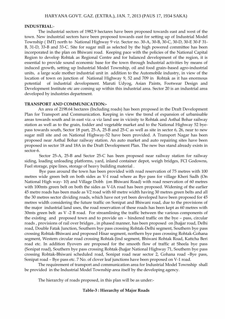
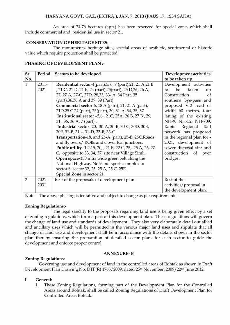
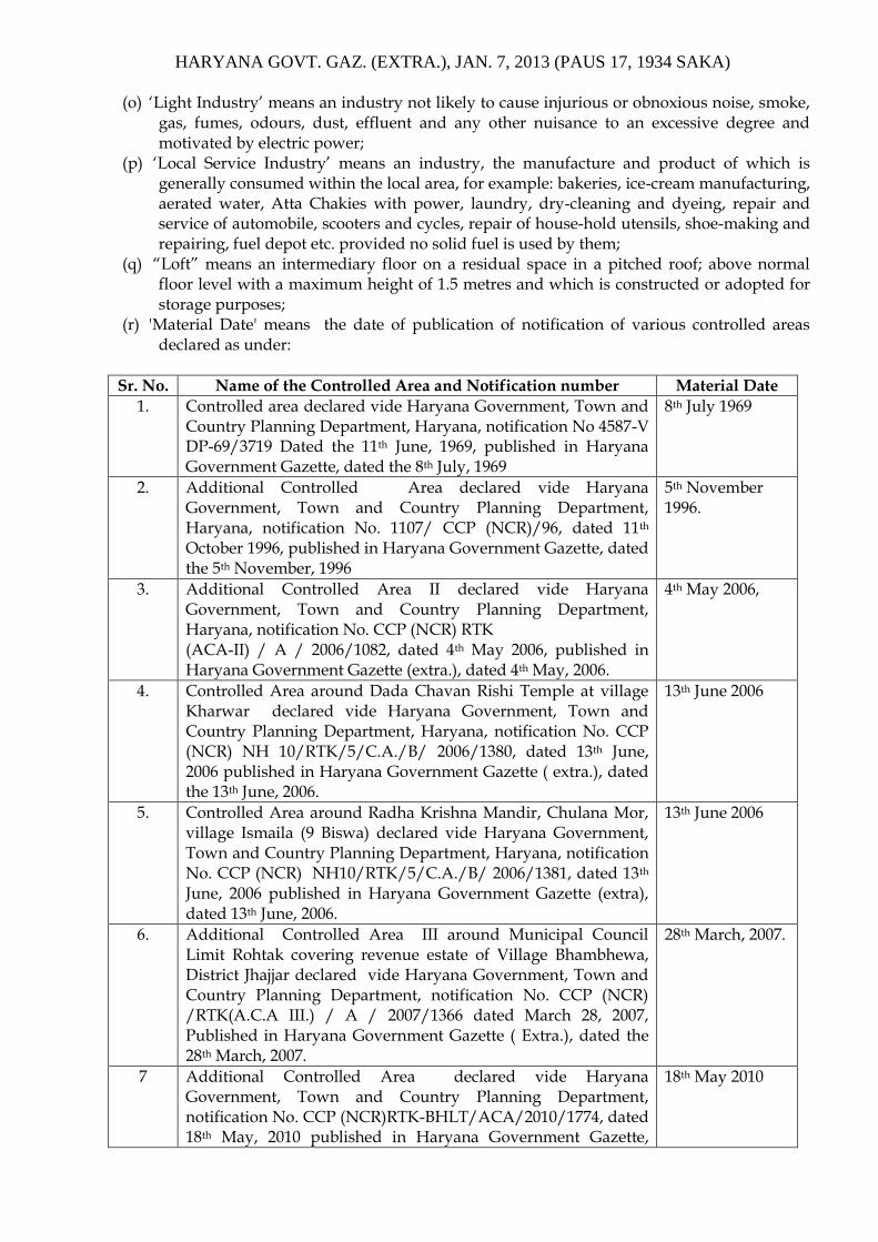
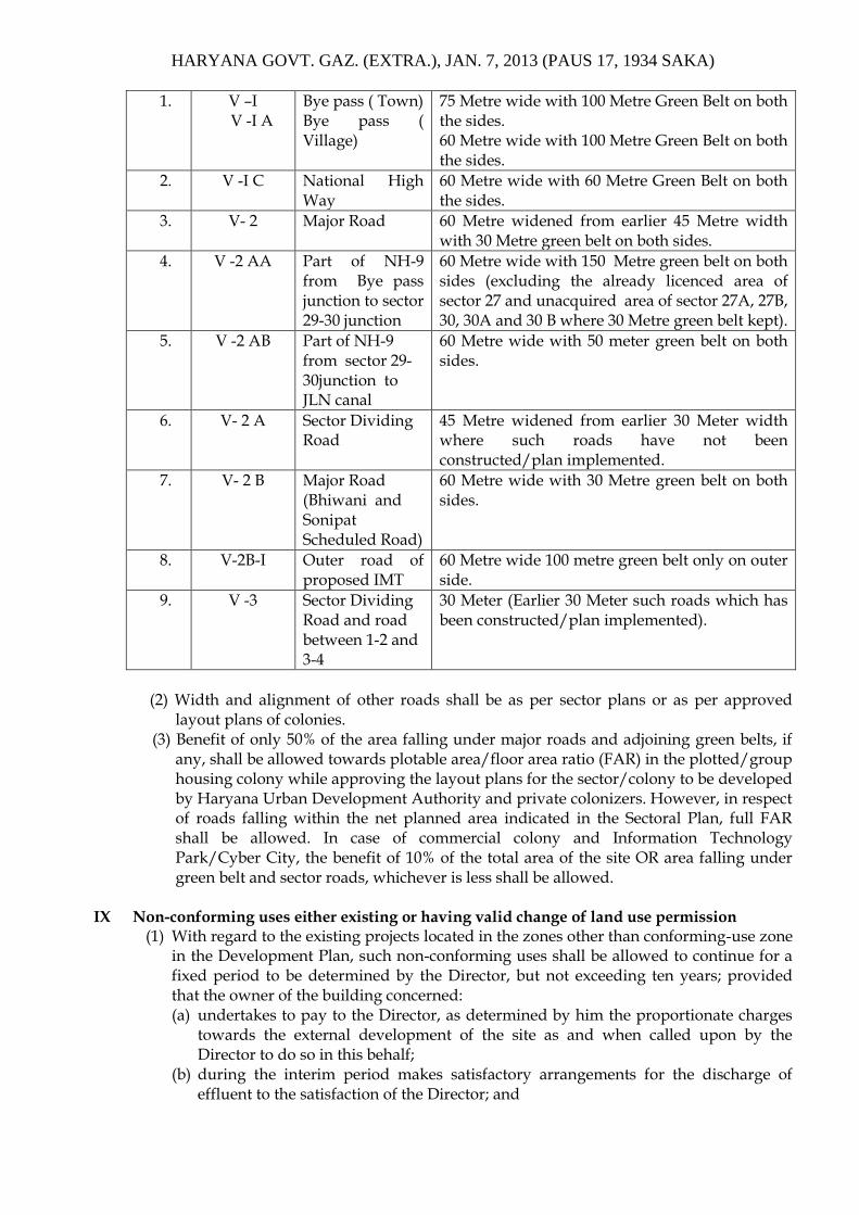
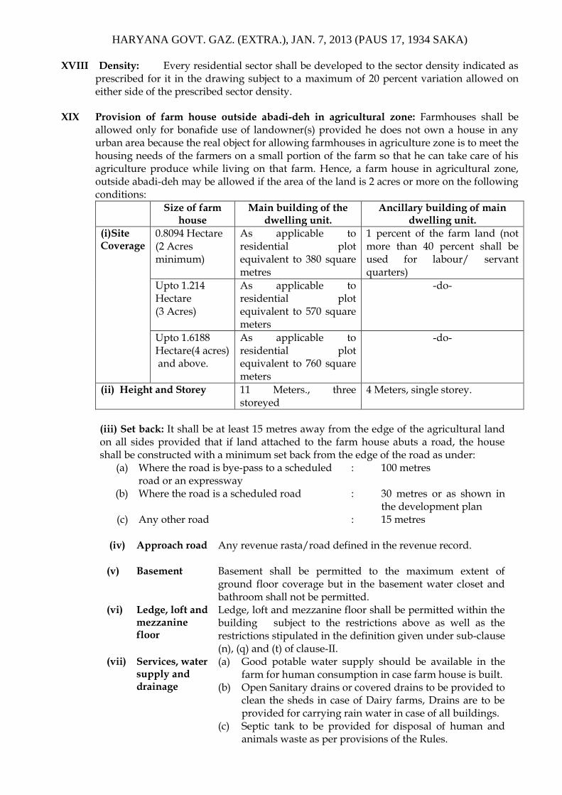
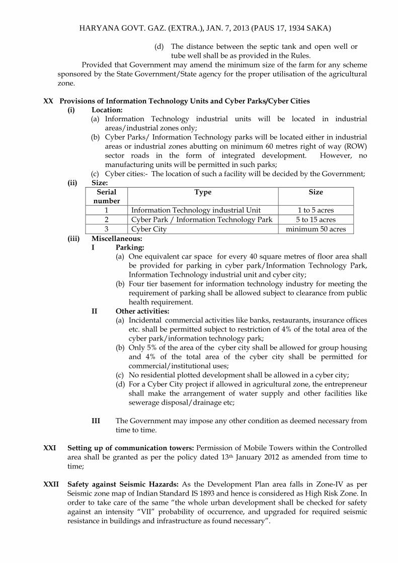
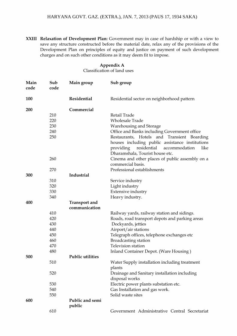
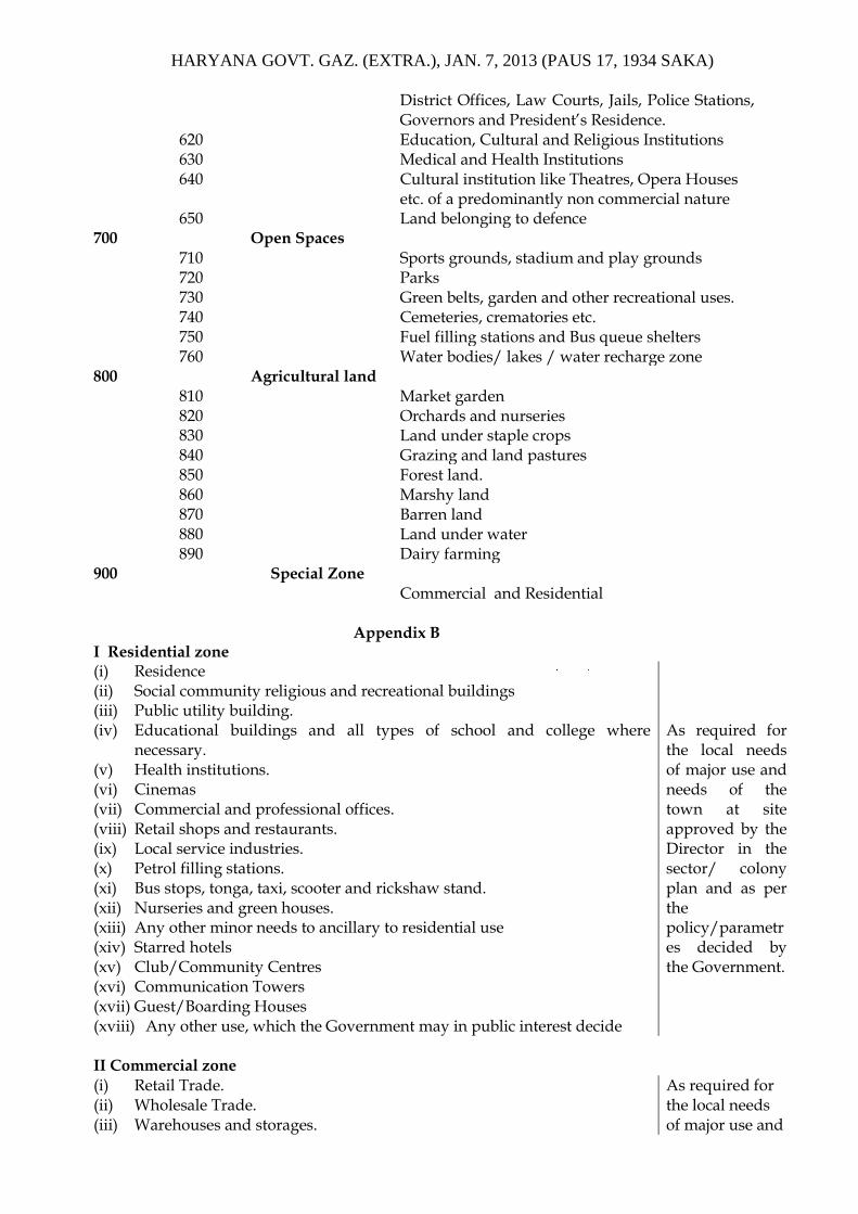
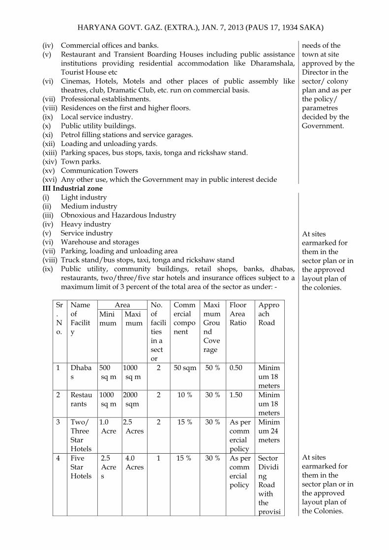
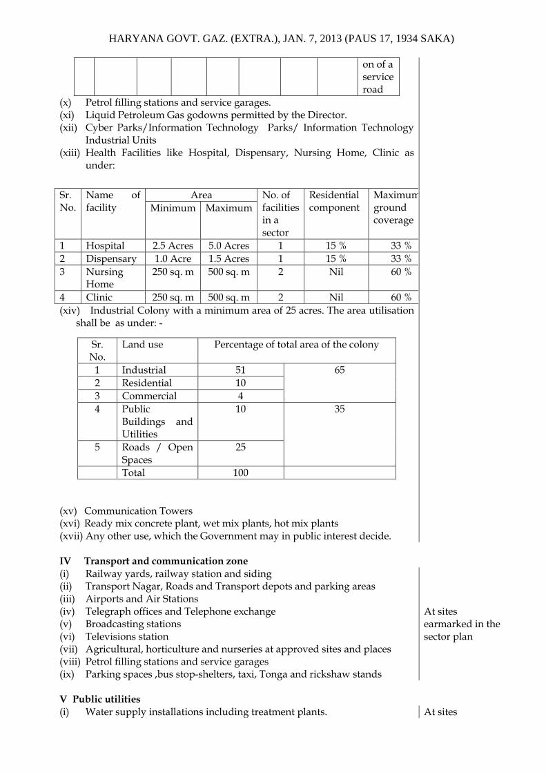
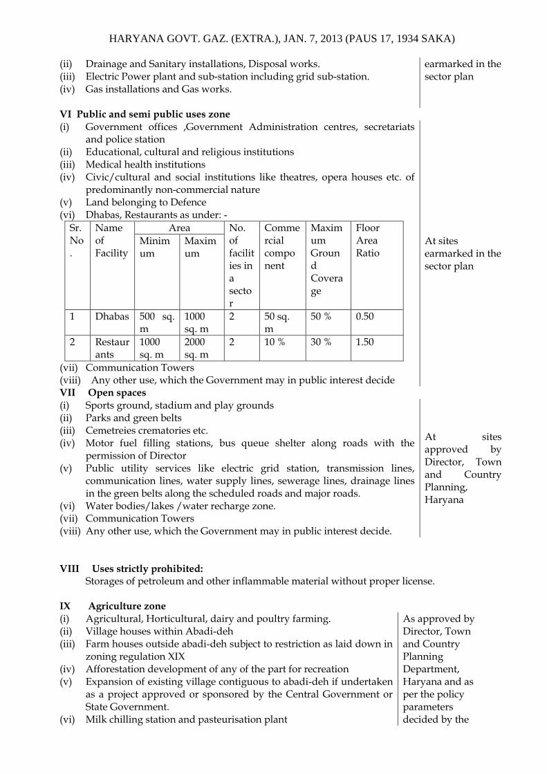
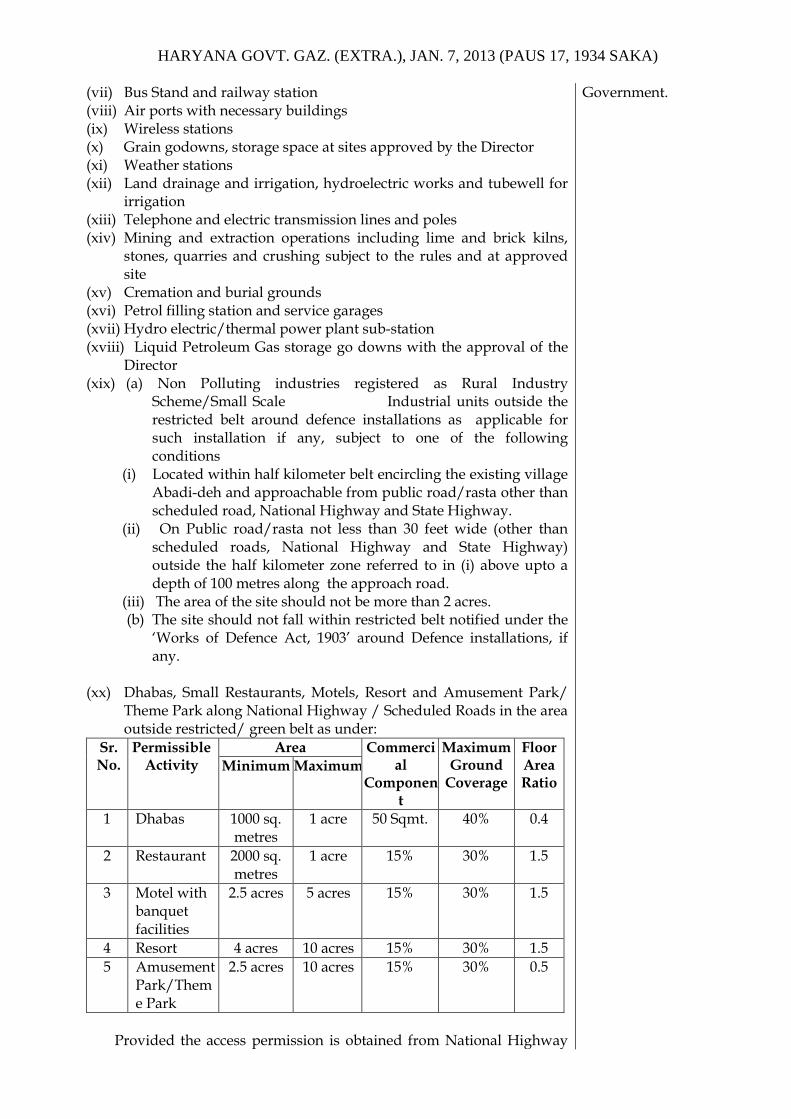
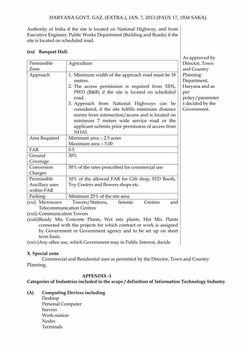
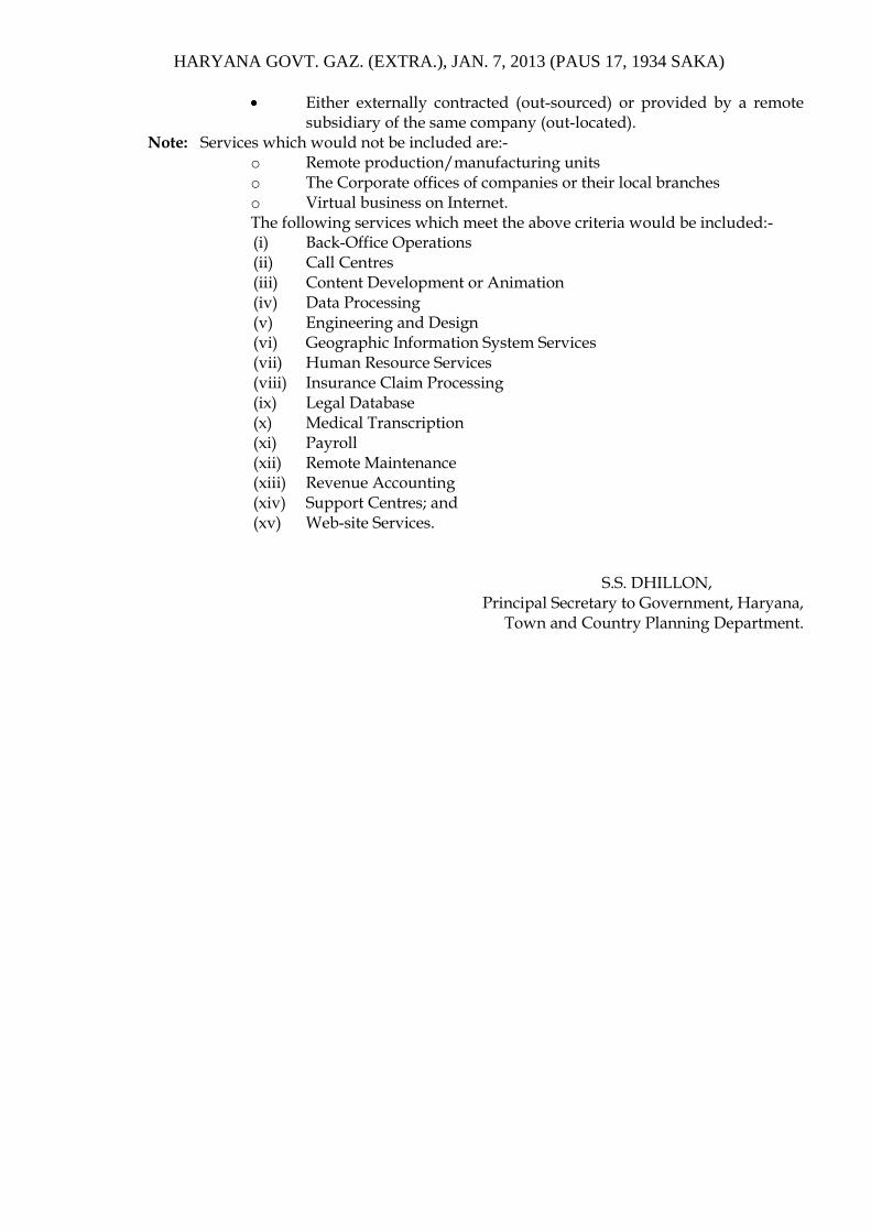


![AC DC - · PDF fileYerel yönetmeliklere göre topraklama [mbar] EN 161 [ V ] °C 0 +60-15 IEC 529 Gas Gaz](https://static.dokumenty.site/doc/80x56/5a77c7587f8b9ad22a8e707b/ac-dc-a-yerel-yanetmeliklere-gare-topraklama-mbar-en-161-v-ac.jpg)


![ncert.nic.in · 4 hours ago · of Gover:nrnent of india or C*tate Govt&llnments ÌSEaí:iona] I for Entrepreneurship and Smaìi Business Development, (NI Indian Institute of' Entrepreneurship](https://static.dokumenty.site/doc/80x56/5fe3c10bfe764944e30392d6/ncertnicin-4-hours-ago-of-governrnent-of-india-or-ctate-govtllnments.jpg)


