237

Historická geografie
38/1 (2012)
HISTORICKÁ GEOGRAFIE / HISTORICAL GEOGRAPHY
38/1 (2012) VEDOUCÍ REDAKTOR / EDITOR-IN-CHIEF PhDr. Robert ŠIMŮNEK, Ph.D. ([email protected]) REDAKČNÍ RADA / ASSOCIATE EDITORS PhDr. Pavel BOHÁČ, Český úřad zeměměřický a katastrální, Praha Ing. Jiří CAJTHAML, PhD., ČVUT v Praze, katedra mapování a kartografie PhDr. et PaedDr. Jiří DVOŘÁK, Ph.D., Historický ústav Filozofické fakulty
Jihočeské univerzity v Českých Budějovicích RNDr. Václav FRAJER, CSc., Přírodovědecká fakulta Univerzity Karlovy, Praha Dr. Ryszard GŁADKIEWICZ, Universytet Wrocławski, Wrocław Mgr. Eva CHODĚJOVSKÁ, Historický ústav Akademie věd České republiky, v. v. i., Praha doc. RNDr. et. Mgr. Peter CHRASTINA, Ph.D., Univerzita Konštantína Filozofa, Nitra RNDr. Pavel CHROMÝ, Ph.D., Přírodovědecká fakulta Univerzity Karlovy, Praha prof. PhDr. Eva SEMOTANOVÁ, DrSc., Historický ústav Akademie věd České
republiky, v. v. i., Praha PhDr. Robert ŠIMŮNEK, Ph.D., Historický ústav Akademie věd České republiky,
v. v. i., Praha prof. PhDr. Josef ŽEMLIČKA, DrSc., Historický ústav Akademie věd České
republiky, v. v. i., Praha VYDÁVÁ / PUBLISHED BY Historický ústav Akademie věd České republiky, v. v. i., Praha The Institute of History, Academy of Sciences of the Czech Republic, v. v. i., Prague ADRESA / ADRESS Prosecká 76 190 00 Praha 9 – Nový Prosek TEL.: (+420) 283 882 138 ZKRATKA ČASOPISU / JOURNAL SHORTCUT HG HG vychází dvakrát ročně / HG is published twice a year ISSN 0323–0988
HISTORICKÁ GEOGRAFIE
HISTORICAL GEOGRAPHY
38/1
Historický ústav
Praha 2012

ISSN 0323–0988 © Historický ústav, Praha 2012

5
PREFACE
It never behooves us to neglect a tradition. This year has marked 32 years since the pub-lication of a number of contributions presented as a part of Section 9 – Historical Geo-graphy, on the occasion of the 24th International Geographical Congress in Tokyo (1980), in volume 19 of Historical Geography (Historická geografie). It has also been 24 years since the publication of the 27th volume of Historical Geography, presented on the occasion of the 26th International Geographical Congress in Sydney (1988). In both volumes, Czech authors make up more than a half of the contributors, and the contributions (and their wide-ranging spectrum) as a whole reflect the development and results of historical geography at home. The discipline’s beginnings reach all the way to the 19th century and it has since the second half of the 1960s emerged as a scientific discipline, which, however, had to fight for its place in the constellation of scientific disciplines. Now, a quarter century later, we welcome the publication of another “congress” volume, the 38th, of Historical Geography, presented on the occasion of the 15th International Conference of Historical Geographers in Prague (2012).
The conception of this volume is different from previous volumes. Eight studies offer a representative window into the current trends of historical-geographical research in the Czech Republic, not only from the chronological but also from the thematic angle. The introduction describes the recent results of various research initiatives in historical geography in the Czech Republic and also the current status of the academic discipline as a whole as well as the challenges facing specifically the Czech branch of historical geo-graphy. Year 2012 is an important year for the Czech historical geography, also from the perspective of institutionalization of the joint platform of the historical-geographical research (the platform involves the establishment of the Historical Geography Research Center based on a seven-year grant project that supports excellence in the basic research and is backed up by the Grant Agency of the Czech Republic, project P410/12/G113).
The first section, arranged chronologically, is opened by a study dedicated to questions, under discussion in the present day and potentially also in the future, being researched by specialists in the field of historical geography in the Czech Republic between the 13th and 15th centuries. The study also hints at a wider spectrum of related topics, from history to archeology, toponymy and literary studies, art history, economic and social history, but,
6
peripherally, also natural sciences. The same holds true for the subsequent contribution, dedicated to the period between 16th and 18th century; here, the discussion is accompanied by lists of basic collections and editions of cartographic and iconographic materials. The potential of further study of the baroque designed landscape, which is a specific pheno-menon in the context of historical-geographical research, is demonstrated on different examples of natural parks as well as objects of study by the historical geography (principles of creation and development of parks, and their ideological underpinnings, and their relation-ship to the natural and cultural-social environment).
The second section, arranged thematically, is focused on the more recent period, between the 19th and 20th / 21st century. The starting point here is the evolution of land-scape in the Czech lands in the course of the 19th century, the process of transformation from the baroque landscape to the industrial landscape, which includes several determining factors, which were distinctly reflected in the landscape structures (industrialization, urbaniza-tion, development of traffic infrastructure etc.). The next contribution focuses specifically on urban areas and, relying on historical geographical research maps, it maps the impact of industrialization (a number of negative influences related to the development of industry evoked criticisms of the city, and led to renewals of interest in urban landscape, greenery and nature – public greenery as a category of its own kind is precisely an invention of the 19th century).
The study on the subject of transformations of village landscape in the Czech border areas in the second half of the 20th century reflects the trends in historical-geographical research in the period after WWII. It describes the main processes that influence the functioning of local landscapes in the period under discussion (landscape changes on the local level are introduced through an analysis of a selected model area). The dualism of Europe is a complex, dynamic phenomenon that has in the past fluctuated; it is a global topic, which revolves around four key aspects of the duality (seen through the eyes of a historical geographer): cultural, economic-social, political and ethnic.
The Landscape Atlas of the Czech Republic (Atlas krajiny České republiky) and the Historical Town’s Atlas of the Czech Republic (Historický atlas měst České republiky) both received a special mention of all the different research and publication projects, as comparatively-conceived international projects of broader interest.
Czech historical geography at the beginning of the third millennium is a discipline that can distinctly influence the creation and protection of contemporary landscape through the consideration of historical context of past landscapes and contribute to the under-standing and development of landscape in accordance with the European agreement about landscape. The discipline of historical geography brings us nearer to nature, from which we came, it teaches us to be aware, perceive and understand the rules of their mutual coexistence. It endeavors to make the memory of landscape the inseparable part of our national and European cultural heritage.
Editorial board
ARTICLES

HISTORICKÁ GEOGRAFIE 38/1 (2012)
http://www.hiu.cas.cz/cs/mapova-sbirka/historicka-geografie.ep/
9
Eva Semotanová – Pavel Chromý*
DEVELOPMENT AND CURRENT TRENDS OF THE CZECH HISTORICAL GEOGRAPHY
Keywords
Abstract
historical geography history of historical geography historical landscape Czechia
The contribution presents existing results of the Czech historic-geographical research, the current state of scientific discipline, and also challenges that is the Czech historical geography facing. It deals with development of thematic orientation of historic-geographical research in course of the 20th century, introduces leading persons of individual generations and define the three today’s theoretic-methodological orientations of historic-geographical research. Since the year 2012 historic-geographical research has gained a common institutional platform: the Historical Geography Research Centre. Further research in the field of historical geography in Czechia will develop the Baker’s four key traditions of historical geography: changing distribution, changing environments, changing landscapes, changing areas and regions
* Prof. PhDr. Eva Semotanová, DrSc., The Institute of History, Academy of Sciences of the
Czech Republic, v. v. i., Prosecká 76, Praha 9, CZ – 190 00. E-mail: [email protected]. – RNDr. Pavel Chromý, Ph.D., Charles University in Prague, Faculty of Science, Department of Social Geography and Regional Development, Albertov 6, Praha 2, CZ – 128 43. E-mail: [email protected]. – This article is a result of the research project “Historical Geography Research Centre”, supported by The Grant Agency of the Czech Republic (No. 410/12/G113).
Eva Semotanová – Pavel Chromý
Historická geografie 38/1 (2012) 10
Introduction
Historical geography in the Czech Lands was established in the 19th century together with many other (modern) disciplines of scholarship. Its roots are thus quite deep; the fifth generation of scholars has symbolically been professing it from the imaginary arbor vitae. Holding the 15th International Conference of Historical Geographers in Prague in August 20121 presents one of the new-age milestones in the development of the discipline not only in the Czech, but probably also in the entire Central European milieu. The Czech historical geographers percept this important event as an opportunity to introduce the results of the Czech historic-geographical research, the current condition of this discipline and the challenge that the Czech historical geography is facing to international professionals. While collaboration on historical geography has largely been determined by institutionalism over the past two decades and the research has proceeded within the “historical” and “geographical” wings of the Czech historical geography, the year 2012 is important for institutio-nalisation of a joint platform in the historical geography research. The platform in-volves establishment of the Historical Geography Research Centre based on a seven-year grant project that supports excellence in the basic research and is backed up by the Grant Agency of the Czech Republic.2 Building the imaginary “bridge” between history and geography has thus come true.3
The advancement of historic-geographical thinking, development of the discipline and discussions regarding conceptual issues served as a topic for several studies published mainly in Czech in Historická geografie throughout the 1980s.4
1 Refer to http://www.ichg2012.cz. 2 Project P410/12/G113 Historical Geography Research Centre (Main applicant: Prof. Eva
Semotanová – The Institute of History, Academy of Sciences of the Czech Republic, v. v. i., Prague; co-applicant: Dr. Pavel Chromý – Charles University in Prague, Faculty of Science, Prague; 16 members of the research team in total).
3 We must not forget the disciplinary periodical Historická geografie, which has been in print since 1968, an existence and activity of the Commission for Historical Geography attached to the Institute of History, Academy of Sciences of the Czech Republic, v. v. i. and the Historical Geography and Environmental History Section of the Czech Geographical Society and, over the past decade, the traditional annual conferences of historical geographers, that hitherto acted as a platform for mutual collaboration among interested researchers representing various disciplines. The establishment of the joint research centre, however, means a change in historic-geographical research on an institutionally and qualitatively different level.
4 Alan R. H. BAKER, Historical geography in Czechoslovakia, Area 18, 1986, pp. 223–228; Zdeněk BOHÁČ, Úkoly komise pro historickou geografii při ČSAV a tematické okruhy prací, publikovaných ve sborníku Historická geografie v letech 1968 až 1982 (vol. 1–20) [Tasks of the
Development and Current Trends of the Czech Historical Geography
Historická geografie 38/1 (2012) 11
As regards more recent works, we should mention the most important works, i.e.: Historická geografie českých zemí [Historical Geography of the Czech Lands]5 by Eva Semotanová and works by Zdeněk Boháč, Pavel Chromý, Leoš Jeleček, Ota Pokorný, Eva Semotanová and Jaroslav Vaniš.6 The authors discuss formation of
Commission for Historical Geography Attached to CSAS and thematic spheres of works published in the Historická geografie collection between 1968 and 1982 (vol. 1–20)], HG 22, 1983, pp. 69–95; Leoš JELEČEK, Current Trends in the Development of Historical Geography in Czechoslovakia, HG 19, 1980, pp. 59–102; IDEM, Historická geografie v Československé akademii věd a v Česko-slovensku 1952–1982 [Historical geography in the Czechoslovak Academy of Sciences and in Cze-choslovakia between 1952 and 1982], Geografie 88, 1983, pp. 213–222; IDEM, Nástin vývoje československé historické geografie [Outline of the development of the Czechoslovak historical geography], HG 22, 1983, pp. 11–51; Dušan TRÁVNÍČEK, K vývoji české historické geografie po druhé světové válce [To the development of the Czech historical geography after World War II], HG 22, 1983, pp. 53–60.
5 Eva SEMOTANOVÁ, Historická geografie Českých zemí [Historical Geography of the Czech Lands], Praha 1998 (2nd updated edition 2002, 2006).
6 Zdeněk BOHÁČ, Nové perspektivy Komise pro historickou geografii [New perspectives of the Commission for Historical Geography], HG 28, 1995, pp. 7–9; Pavel CHROMÝ, New trends in Czech and world historical geography, in: Acta Facultatis Rerum Naturalium Universitatis Comenianae, Geographica Supplementum, 1999, No. 2/I, pp. 267–278; IDEM, Výzvy pro českou historickou geografii [Challenges for the Czech historical geography], HG 31, 2001, pp. 87–108; Leoš JELEČEK, K utváření a koncepci historické geografie životního prostředí [To the creation and conception of historical geography of the environment], GGÚ ČSAV Reports 27, (Praha/Brno) 1990, pp. 5–15; IDEM, Nová historiografie? Environmentální dějiny v USA: vývoj, metodologie, výsledky [New historiography? Environmental history in the USA: development, methodology, results], ČČH 92, 1994, pp. 510–540; IDEM, Environmentální dějiny v USA a geografie [Environ-mental history in the USA and geography], Geografie 99, 1994, pp. 261–269; IDEM, The Ecological Situation Changes in the Czech Republic 1948–1989: Some of their Historic–Geographical Causes and Connections, in: The Changing Nature of the People–Environment Relationship: Evidence from a Variety of Archives, edd. Ian G. Simmons – Antoinette M. Mannion, Prague 1995, pp. 101–111; IDEM, Historická geografie [Historical geography], in: Všeobecná encyklopedie o čtyřech svazcích [Comprehensive Encyclopaedia in Four Volumes]. Vol. 2, Praha 1997, p. 174; IDEM, Environmentalizace historické geografie, historiografie a historický land use [Environmentalisa-tion of historical geography, historiography and historical land use], HG 30, 1999, pp. 53–84; IDEM, Environmentální dějiny v Česku, Evropě a USA: počátky a některé širší souvislosti [Environmental history in Czechia, Europe and the USA: the origins and some broader connections], Klaudyán 3/2000, see http://klaudyan.psomart.cz and http://www.klaudyan.cz; IDEM, Environmentální dějiny a česká historiografie a historická geografie [Environmental history and Czech historio-graphy and historical geography], in: VIII. sjezd českých historiků, Hradec Králové 10.–12. září 1999, ed. Jiří Pešek, Praha 2001, pp. 306–325; Ota POKORNÝ, Historická geografie a geogra-fická historie [Historical geography and geographical history], Geografie 97, 1992, pp. 114–116; Eva SEMOTANOVÁ, Historická geografie. Zmizelý prostor a čas [Historical geography. The lost space and time], ČČH 93, 1995, pp. 177–188; EADEM, Kam směřuje naše historická geografie?
Eva Semotanová – Pavel Chromý
Historická geografie 38/1 (2012) 12
individual historical geography directions that have originated in this country over the past century. They usually base their discussions on analyses of thematic re-search into individual schools or, should we say, their “leading” personalities. The current research tendencies, however, can also be evaluated in theoretic-methodo-logical aspects and within international circumstances. When specifying the subject of the Czech historical geography, this evaluation even seems inevitable.
This contribution introduces historical geography, its advance and formation into a separate field of scholarship, forming of individual schools, transformations of the thematic focus and the future of research within the newly established re-search centre. On a general level, the authors contribute to a never-ending discussion on the relation between historiography and geography.
Historical geography: the essence of existence
The relationship between historiography and geography and the actual position of historical geography in the system of scholarly disciplines has long belonged to the traditional topics of discussion within the community of historical geographers, historians and geographers not only abroad,7 but also in Central Europe.8
[Where is our historical geography heading for?], HG 28, 1995, pp. 11–16; EADEM, Historická geografie a její místo v systému věd [Historical geography and its place in the system of sciences], AUC – Philosophica et Historica 1996, No. 1 (= Z pomocných věd historických 13), pp. 115–122; EADEM, Historickogeografický výzkum v Historickém ústavu AV ČR [Historic-geographical research in the Institute of History of the AS CR], HG 29, 1997, pp. 374–375; Jaroslav VANIŠ, Historická geografie jako vědní obor [Historical geography as a scientific discipline], HG 2, 1969, pp. 3–21.
7 For example Alan R. H. BAKER, Historical geography: a new beginning?, Progress in Human Geography 3, 1979, pp. 560–570; IDEM, Některé aspekty britské historické geografie v letech 1966–1986 [Certain aspects of the British historical geography between 1966–1986], HG 26, 1987, pp. 25–43; IDEM, On Relations of Geography and History, Historically Speaking 5, July/August 2004, 6, pp. 27–29; IDEM, Geography and History: Bridging the Divide, Cambridge 2003; IDEM, On the Significance of History for Geography: Historical Geography as Holistic (or Total) Geography, Klaudyán 4/2007, 1, pp. 7–12, see http://www.klaudyan.cz; Robert A. BUTLIN, Historical geography: through the gates of space and time, London 1993, Brian GRAHAM – Catherine NASH, Modern Historical Geographies, Edinburgh 2000.
8 Pavel CHROMÝ – Leoš JELEČEK, Tři alternativní koncepce historické geografie v Česku [Three alternative conceptions of historical geography in Czechia], HG 33, 2005, pp. 327–345; Peter CHRASTINA, Historical geography in the 21st century. Annales Universitatis Apulensis. Series Historica 13, 2009, pp. 183–195; Zdeněk KUČERA, Historical geography between geography and historiography, Klaudyán 5/2008, 1, pp. 5–13, see http://www.klaudyan.cz; IDEM, Historická geografie mezi geografií a historiografií [Historical geography between geography and historio-
Development and Current Trends of the Czech Historical Geography
Historická geografie 38/1 (2012) 13
The present Czech historical geography (as a separate branch of scholarship) has a strongly trans-disciplinary character. It touches the Earth and the man, connects the space with the time, natural sciences with social and technical sciences and humanities. It monitors not only the condition and transformations of the geographical environment in the past, causes that created the transformations, their conditionality and consequences (or corresponding rules), but also perception of the space, meanings that the society and the individuals attributed to the organisation of space and changes of the environment (e.g. in the context of formation, reproduction and collapse of regions, relationship to the existence and different meanings of relict and historiographic boundaries in the sense of collaboration barriers). It makes an effort to grasp and understand historical roots of the present condition and character of the geographic milieu on various a regional levels and in different types of land-scapes; recognition, interpretation and explanation of the development of mutual relations between the people and the inhabited environment and problems arising from their “failures”.9
It is obvious that, with growing inter-disciplinary or multi-disciplinary approaches to solving current social and environmental issues, the traditional clas-sification of sciences and searching for imaginary positions of historical geography among scholarly disciplines and an effort to delimitate “accurate” boundaries between individual disciplines or a definition of the historical geographers’ roles present a merely partial matter. In a sense, they involve a “social construct” that proves the scholars’ need for self-identification, reproduction, development and innovation of the research tradition, or in some case justify the essence of their scholarly and pedagogical activities. When the recognition process is governed by elementary sciences, this searching may seem pointless and inconceivable to many people. We need not explain this fact to representatives of a discipline that has been immanent to an inter-disciplinary approach for more than a century and whose identity has been outwardly weakened by akin “new” disciplines.10 In this situation, however, the hitherto more or less underestimated discussion regarding application of the existing historic-geographical understanding, methodological approaches and utilisation of
graphy], HG 34, 2007, pp. 9–19; Eva SEMOTANOVÁ – Pavel CHROMÝ, Historická geografie: most mezi historií a geografií [Historical geography: A bridge between history and geography], in: Historie v kontextu ostatních vědních disciplín [History in the context of other scholarly disciplines], edd. Jan Dvořák – Tomáš Knoz, Brno etc. 2008 (= IX. sjezd českých historiků. Pardubice 6.–8. září 2006), pp. 231–246.
9 E. SEMOTANOVÁ – P. CHROMÝ, Historická geografie (see note 8). 10 Here we mean environmental history, for example.
Eva Semotanová – Pavel Chromý
Historická geografie 38/1 (2012) 14
“traditional” historic-geographical sources of information in solving the mentioned issues of the social and natural character should be regarded as fundamental.
Do historians need geography and geographers history? Together with Alan R. H. Baker,11 we believe so. Historical progress occurs in a changing geographical milieu. Knowledge of development of this environment’s spatial organisation is necessary not only for understanding the historical events, but mainly the trajectories of the historical advancement. Application of geographical knowledge in historical work is commonplace. Periodisation of history is connected with periodisation of landscape development, especially as regards settlements, communications and boundaries, but also the natural sphere. The man’s activities in the political, eco-nomical and cultural spheres coincide with the landscape and the environment. Even natural disasters can play an important role in periodisation of the society’s history. The space, or shall we say the landscape, is a “Theatrum mundi” – it creates a stage of events and processes that take place in time, where the actors do not enter or leave – the actors, i.e. the man and the society, are merely present on the stage. In historiography, recognition of the countryside contributes to detection of many process origins and connections in the historical development. It is historical geo-graphy and special utilisation of historical (reconstruction) maps used as a method and tool for research and processing of scholarly outcomes that provide the historians with recognition of the landscape in the past (and the “past”, already transformed landscapes). Understanding development of the geographic environment, or perhaps interaction between the society and the environment, is also essential for under-standing its current condition, forecasting and planning the future (conceiving the advancement and affecting the future development of the territory). It is impossible to explain the current problems of the society and activities of the individuals in the environment (including motivations and value orientation of the individual/society), processes and mechanisms applied in the socio-spatial changes (development of territorial differentiation) without knowing the history and development contexts. Without knowledge of the history, it is also impossible to easily distinguish whether socio-spatial changes come as a result of general dominant processes (concentration or deconcentration of functions, diffusion of innovations, industrialisation, urbanisa-tion, suburbanisation etc.) or temporarily and spatially restricted, unique and unrepeat-able specific processes (in the Czech milieu, e.g. the transfer of the Czech Germans after World War II, insufficient settlement of borderland areas, creation of the Iron Curtain). Whether they come as a result of the structures or whether the socio-spatial changes were primarily not caused by the given space and time of the key actors’/subjects’ initiative (e.g. members of royal families, noblemen, politicians,
11 History is not intelligible without geography. – Geography is not intelligible without history. A. R. H. BAKER, On the Significance (see note 7), p. 7.
Development and Current Trends of the Czech Historical Geography
Historická geografie 38/1 (2012) 15
businessmen, environmentalists, public and private institutions, professional developers, networks of actors, etc.) both outside and inside the monitored territory. Whether they are not the result of deepening socio-economical or socio-cultural differences between spatial units and territorial communities (“central–semiperipheral–peripheral”, “rich and poor”, “advanced and undeveloped”; territorially graspable differing patterns in the behaviour and conduct of individuals, tension and conflicts arising from the dichotomy “we” and “others”), perhaps even efforts to “straighten up” or “cure” territorial or social inequalities (e.g. by means of developing strategies or various policies affecting development of the society’s geographical organisation).
Emergence and development of the Czech historical geography
As mentioned above, the tradition of historical geography in the Czech Lands reaches deep into the second half of the 19th century when historians and geographers started to realise the mutuality and inseparability of the perceived environment (landscape) and historical evolution.12 Historiography and geography gradually came closer. Topographic and natural history works by historians František Palacký, August Sed-láček or Václav Vladivoj Tomek emerged. These and the other leading personalities of the Czech scholarly life enriched historiography and geography with new approaches, supported by topographic and cartographic sources and methods.
Historical geography as a scientific discipline, however, emerged after the establishment of Czechoslovakia in 1918. Until the second half of the 20th century, historical geography progressed in the spirit of scholarly postulates by the leading persons in this discipline Josef Vítězslav Šimák, Bohuslav Horák, Ladislav Hosák and František Roubík. It focused on regional national history and geography (home-land), history of geography, historical topography and geographical terminology. Specifics of geographical terminology that first appeared in the Czech Lands in the early Middle Ages in connection with Celtic, Antique and German roots, include triple-language geographical names (Latin, Czech, German) and important turnovers, especially after World War II. At present, toponymy, i.e. study of geographical names, is a separate discipline, closely connected with historical geography. This era of the Czech historical geography can be classified as “traditional” from a perspective of theory and methodology. This applies, although the Czech historical geography was not connected with the “traditional” British historical geography, which was established by H. C. Darby in the 1930s.13
12 E. SEMOTANOVÁ, Historická geografie (see note 5). 13 Ronald J. JOHNSTON – Derek GREGORY – Geraldine PRATT – Michael WATTS,
The Dictionary of Human Geography, Oxford 2000, pp. 337–341.
Eva Semotanová – Pavel Chromý
Historická geografie 38/1 (2012) 16
After the second half of the 20th century, a cartographic method and cartographic as well as tangible sources were applied in the Czech historical geography.14 Theoretical works focused on a definition of the discipline and its position in the system of sciences as separate disciplines, partial geographical sciences or auxiliary historical sciences. Collaboration with medieval archaeology and historical demography developed in the historiographic field, mainly as regards study of historic-geographical contexts involving history of settlements. If compared with the development of the British historical geography, this stage of the Czech historical geography can be specified as “modern”. Nomothetically oriented works affected by the quantitative revolution, focused on a long-term development of the settlement system, emerged in geography. Despite a great emphasis on evolutionary assessment, they were never classified as works of a historic-geographical character and their creators never advocated historical geography.15
In the late 1980s, ecological topics first appeared in the Czech historical geo-graphy as a result of environmentalisation of the society, prompted by deterioration of the environment. Theory, methodology and systemising in historical geography have been tackled by Jaroslav Kašpar, Leoš Jeleček, Zdeněk Boháč, Eva Semotanová. Although the British historic-geographical research was called “post-modern” with regard to the man’s study of geographical changes and in the USA, environmental history developed in the 1970s, the Czech historical geography still oscillated topi-cally and methodologically within the “traditional” and “modern” historical geo-graphy. This fact contributed to a certain delay of the Czech historic-geographical research behind the international trends that focused on regional historical geo-graphy, cultural historical geography and environmentalisation of the discipline in the last quarter of the 20th century.
However, during the 1990s and the early 21st century, the Czech historical geography successfully balanced the theoretical methodology delay.16 The greatest merit is credited to Leoš Jeleček and Eva Semotanová who introduced newly con-ceived research topics to the Czech historical geography – they stood at the birth of
14 The most significant work that appeared in the Czech historical geography in this period
is undoubtedly Atlas československých dějin [Atlas of the Czechoslovak History], ed. Jaroslav Purš, Praha 1965.
15 E.g. Martin HAMPL – Václav GARDAVSKÝ – Karel KÜHNL, Regionální struktura a vývoj systému osídlení v ČSR [Regional Structure and Development of the Settlement System in CSR], Praha 1987.
16 Pavel CHROMÝ, Historická a kulturní geografie a nové přístupy v regionálním studiu [Historical and Cultural Geography and new approaches in regional studies], Dissertation thesis, Charles University in Prague, Faculty of Science, Dept. of Social Geography and Regional Develop-ment, Prague 2004.
Development and Current Trends of the Czech Historical Geography
Historická geografie 38/1 (2012) 17
its current dominating subject orientation (mainly long-term land use changes and historical towns) –, but also a new generation of historical geographers (Eva Cho-dějovská, Pavel Chromý, Zdeněk Kučera, Robert Šimůnek, Aleš Vyskočil).
Theoretical and methodological essence of the Czech historical geography: research objectives
The current Czech historical geography is a dynamically developing discipline. It reflects advancement in social, natural and technical sciences as well as in humanities. It finds inspiration in them and searches for new topics and potentialities that can be grasped and processed. Historical geography is theoretically and practically connected to a number of other disciplines (e.g. archaeology, history of art, urbanism, history of architecture, conservation, landscape ecology, cartography and geoinformatics, environ-mental history, historical sociology, historical climatology, botany, pedology, etc.).
Historical geography research in Czechia focuses on theoretical and methodo-logical problems of the current historical geography in an international context.17 It pays great attention to basic research into historical (urbanised as well as rural) land-scape as regards revolutionary changes of the Czech landscape in the past, within international (particularly Central European) circumstances and issuing the outputs in professional international and domestic publications. Finally yet importantly, it focuses on education of young research workers who are essential for development of the discipline, lectures and conferences, which enable a closer connection between the life in scholarly and academic workplaces.18
17 See note 8. 18 For example, five dissertation theses on historical geography have been defended over
the past two years. Zdeněk KUČERA, Principy a problémy geografického studia krajiny [Principles and Problems of the Geographic Study of Landscape], Dissertation thesis, Charles University in Prague, Faculty of Science, Dept. of Social Geography and Regional Development, Prague 2010; Silvie KUČEROVÁ, Územní diferenciace elementárního vzdělávání v Česku v 2. polovině 20. sto-letí (Vliv na lokální a regionální rozvoj) [Territorial Differentiation of Elementary Education in Czechia during the Second Half of the 20th Century (Its Influence on Local and Regional Development)], Dissertation thesis, Charles University in Prague, Faculty of Science, Dept. of Social Geography and Regional Development, Prague 2010; Robin RAŠÍN, Krajina česko-rakouského pohraničí: vývoj a dědictví [The Landscape of the Czech-Austrian Borderland: Development and Heritage], Dissertation thesis, Charles University in Prague, Faculty of Science, Dept. of Social Geography and Regional Development, Prague 2010; Aleš NOVÁČEK, Dualita Evropy: histo-rickogeografická analýza vývoje a její vymezení [Duality of Europe: Historic-geographical Analysis of the Development and its Delimitation], Dissertation thesis, Charles University in Prague, Faculty of Science, Dept. of Social Geography and Regional Development, Prague 2010; Markéta ŠANTRŮČKOVÁ, Využití a modelace reliéfu při krajinných úpravách na černínských panstvích
Eva Semotanová – Pavel Chromý
Historická geografie 38/1 (2012) 18
Regarding historiography, we should mention several priority topics that the historical geography research follows or should follow in the future. These topics reflect issues peculiar to the historical science, or perhaps their connection with the space and spaciousness in the sense of a particular landscape. It involves more com-plex and new (analytic) views on the mentioned “stage” of the historical evolution, i.e. development of the Czech landscape throughout the history, including observa-tions of the human role in transformations of the landscape and capturing historical circumstances and causes of landscape transformations. Restoration of regional history in the form of regional analyses, understanding the essence of the region and research into model territories has strongly affected historical geography. Probes into his-torical landscape, Baroque landscape, urbanised and industrialised landscape are subject of processing. Proto-urbanisation and landscape urbanisation processes are frequently discussed issues on an international level. It can be documented by the following atlas projects: Historical Town’s Atlas of the Czech Republic (in print since 1995),19 Landscape Atlas of the Czech Republic (2009),20 Academic Atlas of the Czech History (in print, 2013).
Codifying, structural and evolutional assessment of landscape changes is parti-cularly important for geographic research. This is why research conducted in “geo-graphic” direction of the Czech historical geography over the past two decades has necessarily been affected by geographical “handwriting”. Regarding codification, it particularly involves research into internal differentiation of landscape changes on the level of the state, regions, micro regions and localities. Research into the long-term mid-nineteenth century landscape changes initially focused on evaluation of a database on land utilisation from the first half of the 19th century, interpretation and explanation of trends, connections and conditions of land use changes, mainly in the context of the political and socio-economic development in the Czech Lands (i.e. dominantly positivistic evaluation of a quantitative character). Only then, the out-comes of quantitative analyses were verified by “probing” into model territories on the level of micro regions or individual cadastres in various types of landscape of socio--cultural impacts). The broadly conceived research into land use and land cover changes
[Use of Terrain Modelling to Landscaping in Landscape Parks], Dissertation thesis, Charles Uni-versity in Prague, Faculty of Science, Dept. of Physical Geography and Geoecology, Prague 2011.
19 Component of the European Historic Town’s Atlas Project (under the auspice of the Inter-national Commission for the History of Towns). More than twenty volumes have been published (see the report in this issue, pp. 215–222).
20 Tatiana HRNČIAROVÁ – Peter MACKOVČIN – Ivan ZVARA et al., Atlas krajiny České republiky [Landscape Atlas of the Czech Republic], Průhonice 2009, incl. e.g. Historická krajina. Oddíl 3 [Historical Landscape. Section 3], edd. Pavel Chromý – Tatiana Hrnčiarová – Peter Mackovčin, pp. 73–96 (see the report in this issue, pp. 207–215).
Development and Current Trends of the Czech Historical Geography
Historická geografie 38/1 (2012) 19
interprets social driving forces in landscape transformations, evaluates impact of societal transformations on the landscape (post-industrial, post-totalitarian) and contributes to a discussion on the mechanism of socio-spatial changes (mainly in intensively transformed landscapes, large towns’ neighbourhood, peripheries and border-land).21 Together with the research into the landscape changes, historical geographers
21 For example Ivan BIČÍK – Pavel CHROMÝ – Vít JANČÁK – Leoš JELEČEK – Lucie KUPKOVÁ – Vít ŠTĚPÁNEK – Jana WINKLEROVÁ, Land Use/Land Cover Changes in
Eva Semotanová – Pavel Chromý
Historická geografie 38/1 (2012) 20
Czechia over the past 150 Years – An Overview, in: Land Use/Cover Change in Selected Regions in the World. Vol. I, Part IV, edd. Yukio Himiyama et al., Asahikawa 2001, pp. 29–39; Ivan BIČÍK – Leoš JELEČEK – Pavel CHROMÝ – Lucie KUPKOVÁ – Luděk ŠEFRNA, Comparison of land use changes in and outside biosphere reserves in Czechia, in: Land Use Changes in Comparative Perspective, Chapter 19, edd. Yukio Himiyama et al., New Delhi 2002, pp. 249–258; Ivan BIČÍK – Leoš JELEČEK – Vít ŠTĚPÁNEK, Land-Use Changes and their Social Driving Forces in Czechia in the 19th and 20th Centuries, Land Use Policy 18, 2001, pp. 65–73; Pavel CHROMÝ – Vít JANČÁK – Jana WINKLEROVÁ, Land use changes in the peripheral regions of Czechia, AUC – Geo-graphica 38, 2003, No. 1, pp. 95–103; Jiří JANÁČ – Leoš JELEČEK – Pavel CHROMÝ, LUCC in East Central and Southeast Europe post-communist countries from 1960s to the end of the 20th century and its historic-geographical roots, AUC – Geographica 45, 2010, No. 2, pp. 19–30.
Development and Current Trends of the Czech Historical Geography
Historická geografie 38/1 (2012) 21
concentrate on the landscape memory,22 perception of the landscape transformations, processes forming territorial identities, regions and places23 and relict (historic-geographical) boundaries24 as well as specific landscapes (e.g. military landscapes, defence sites25).
Based on evaluation of thematic focus and outputs of historic-geographical research in Czechia, three dominating (in principle complementary) theoretic-methodo-logical concepts of historical geography can be delimitated within the current Czech historical geography. The first concept represents a traditional, mainly idiographically
22 Pavel CHROMÝ, Memory of Landscape and Regional Identity: Potential for Regional
Development of Peripheral Regions, in: Dealing with Diversity. 2nd International Conference of the European Society for Environmental History Prague 2003, edd. Leoš Jeleček et al., Prague 2003, pp. 246–256.
23 Pavel CHROMÝ – Silvie KUČEROVÁ – Zdeněk KUČERA, Regional Identity, Con-temporary and Historical Regions and the Issue of Relict Borders. The Case of Czechia, Regions and Regionalism 9, 2009, No. 2, pp. 9–19; Zdeněk KUČERA – Silvie KULDOVÁ – Pavel CHROMÝ, Heritage in Landscape or Landscape as Heritage – the Case of Landscape Change Management in Protected and Development Areas in Czechia, Europa XXI 17, 2008, pp. 87–96; Zdeněk KUČERA – Silvie KUČEROVÁ-KULDOVÁ – Pavel CHROMÝ, Landscape heritage between areal preservation and areal development – the case of Czechia, Geographia Polonica 81, 2008, No. 2, pp. 5–23.
24 Pavel CHROMÝ, Historical-Geographical and Cultural-Geographical Research of the Development in Border, Marginal and Peripheral Regions in Czechia, in: Theoretical and Methodo-logical Aspects of Geographical Space at the Turn of the Century, ed. Andrzej Kowalczyk, Warsaw 2003, pp. 187–192; IDEM, Historickogeografické aspekty vymezování pohraničí a jeho geografické analýzy [Historic-geographical aspects of delimitation of the borderland and of its geographical analysis], Geografie 105, 2000, pp. 63–76; IDEM, Historickogeografický pohled na české pohra-ničí [Historic-geographical view on the Czech borderland], in: České pohraničí – bariéra nebo prostor zprostředkování? [Czech borderland – a barrier or a space for mediation?], edd. Milan Jeřábek et al., Praha 2004, pp. 33–44; Pavel CHROMÝ – Jan SKÁLA, Kulturněgeografické aspekty roz-voje příhraničních periferií: analýza vybraných složek územní identity obyvatelstva Sušicka [Cultural-geographical aspects in the development of borderland peripheries: An analysis of selected elements of territorial identity among residents of the Sušicko region], Geografie 115, 2010, pp. 223–246; Silvie KULDOVÁ – Zdeněk KUČERA, Historická česko-německá etnická hranice a proměna krajiny pohraničí [Historical Czech-German ethnic border and transformation of the borderland], in: Historie v kontextu ostatních vědních disciplín [History in the context of other scholarly disciplines], edd. Jan Dvořák – Tomáš Knoz, Brno etc. 2008 (= IX. sjezd českých historiků. Pardubice 6.–8. září 2006), pp. 247–261.
25 Tomáš SEIDL – Pavel CHROMÝ, Environmental Conservation in military training areas – source of spatial conflicts? Europa XXI 21, 2010, pp. 103–115. IIDEM, Problémy integrace marginálního území do regionálního systému – příklad vojenského újezdu Boletice [Problems concerning the integration of marginal regions into the regional system: Example of the Boletice military training area], Geografie 115, 2010, pp. 44–63.
Eva Semotanová – Pavel Chromý
Historická geografie 38/1 (2012) 22
Development and Current Trends of the Czech Historical Geography
Historická geografie 38/1 (2012) 23
Eva Semotanová – Pavel Chromý
Historická geografie 38/1 (2012) 24
oriented historical geography connected with promoting its recognitory role. This concept has been preferred by historians up to now. The second concept involving modern historical geography is dominant in geography. The third concept involves post-modern (humanistic orientation) historical geography with a significant overlap into cultural geography. Its development can be detected not only in the field of historiography and geography, but also in related (close to historical geography)
Development and Current Trends of the Czech Historical Geography
Historická geografie 38/1 (2012) 25
disciplines. In line with development of the “new” cultural geography, increased attention is paid to manifestations of culture in a way of life and significance of values and standpoints for making decisions regarding various spheres of life in the historical landscapes, including formation of the cultural and natural heritage. The impact of various actors and (territorial) communities on forming the character of their symbolic areas and conflicts regarding the development of the territory re-mains a less treated issue in the Czech historical geography. We can say that the last of the mentioned directions has a significant neo-idiographic accent (it allows con-figuration of specific topics that characterise territorial differentiation of a certain spatial unit and affect its development, while the specific configuration of topics is only partially unique; interpretation of the topics is organized in a nomothetical method).
A significant issue concerning potentialities and boundaries of source research, website application and portals has been tackled in historical geography research in Czechia in the early 21st century and is comparable with international research. After 1989, the Czech historical geography became enriched with systematic utilisation of certain less accessible or completely unavailable research sources. It particularly concerns original copies of the first and second military survey maps from the second half of the 18th and the first half of the 19th century deposited in Staatsarchiv-Kriegs-archiv in Vienna; they were publicised on a map portal of the Geoinformatics Labora-tory, University J. E. Purkyně in Ústí nad Labem (http://www.geolab.oldmaps.cz) after 1989 together with the third military survey maps from the last quarter of the 19th century. These detailed maps contain a large amount of topographic as well as thematic data that are compatible within the entire territory of the Austrian Monarchy. Vertical and oblique aerial photographs, which could not be studied before 1989, also became very important. At present, photographs from the 1930s in a chrono-logical series can be used in an archive of aerial photographs in the Military Geo-graphical and Hydrometeorological Institute in Dobruška under certain conditions. Aerial photographs of the Czech territory present a superb comparative material for understanding transformations of the landscape mainly before and after 1948.
New Czech trends in application of cartographic sources over the past decade involve on-line publication on the Internet. An enormous, perhaps even uncontroll-able advance of digitalisation of map archives, resources and collections is being experienced. However, this hampered by great fragmentation and inhomogeneity mainly in elaboration methodology (e.g. selective criteria of digitalised sources, quality of resolution of the scanned data, cataloguing methods and cataloguing programs, metadata format, etc.).26 Specialists have concentrated on digital processing
26 These facts are currently discussed in two projects of a program entitled National and Cultural Identities granted by the Ministry of Culture CR, i.e. a project called Cartographic sources
Eva Semotanová – Pavel Chromý
Historická geografie 38/1 (2012) 26
of these map sources, thus allowing more advanced utilisation over the past few years. These potentialities include comparison of illustrations on old maps by their overlapping (i.e. tessellation, georeferences, change of scale, transparency), automatic searching for (detecting) objects on the maps (i.e. detection of objects in raster pictures), automatic analysis of a content of the digitalised map (i.e. georeference and classification of raster pictures), usage of digitalised maps in user applications (i.e. on-line availability of digitalised maps in a suitable standardised method). However, a mere map digitalisation and free on-line availability is no longer sufficient for browsing.27 We cannot responsibly and definitely determine what opportunities of further processing the cartographic sources can offer, especially as regards maps coming from the pre-nineteenth century because their cartographic illustrative quality is greatly compromised.
Historical geography outputs also gain new forms in Czechia; web portals accompany printed textual outputs, image and map outputs and CD ROMs. We can mention a portal of the Historical Town’s Atlas of the Czech Republic in both Czech and English versions for the No. 19 volume – Královské Vinohrady.28 The authors anticipate its extension with other Prague quarters (former independent towns) Libeň and Smíchov.
The listed methods of presenting map sources or outcomes of scholarly research, however, encounter numerous conceptual, technical and technological challenges. A strong point is that the digitalised map sources are user friendly and the original documents are sufficiently protected regarding protection of the cultural heritage. The weak points include permanency of the on-line outputs, necessity of safe backup, and transfer of the data to new media after some time and even a danger of digital darkness.
as a cultural heritage research in new methodologies and digitalization technologies, availability and utilisation of old maps, plans, atlases and globes (the Research Institute of Geodesy, Topo-graphy and Cartography in Zdiby and the Institute of History, Academy of Sciences of the Czech Republic, v. v. i. in Prague) and the project Technologies for publication of map collections CR: methodology and software for protection and utilisation of cartographic works of the national carto-graphic heritage (the Moravian Land Library in Brno, Faculty of Science, Masaryk University in Brno and Charles University in Prague, Faculty of Science). Map digitalization is also tackled by specialists in archiving science, care of historical monuments, etc.
27 Eva SEMOTANOVÁ – Milan TALICH, Kartografické zdroje jako kulturní dědictví a formy jejich zpřístupňování [Cartographic sources as cultural heritage and forms of their accessing], http://www.czechmaps.cz/data/seminar_041111/Semotanova_Talich_digitalizace_ 2011.pdf, downloaded 26th November 2011.
28 http://maps.fsv.cvut.cz/praha/index.html, downloaded 26th November 2011.
Development and Current Trends of the Czech Historical Geography
Historická geografie 38/1 (2012) 27
Historical landscape as a historical geography topic
Landscape, mainly historical landscape, has become a newly recovered phenomenon in Czechia over the past few years. It tends to be celebrated, mythicised, poetised, covered in spiritualism, idealised, restored – and destroyed. It becomes a cult that can be glorified in emotional verses confessing love to the native land. It is attributed with super-terrestrial and magic properties that breathe out of forests, meadows, rivers and hillsides; in the past, they allegedly decided battles, evoked zealous patriotism, determined the course of history – now, hopefully, they help to find a sense of the earth-life. A modern issue that emerges in connection with historical landscape is “memory of the landscape”, or “soul of the landscape”. Memory of the landscape has become domesticated because of broad popularisation and publicity in the media and is commonly used by many specialists.29 It accurately implies the landscape charisma emanated by locations saturated with history and stories, venerated peaks or romantic nooks with footprints of magic human activity, with memorable trees, springs and wells. Locations that have become a symbol, enveloped with extraordinary “genius loci”. Nevertheless, only the man attributed the landscape with the characters, feelings and images of the human mind. The landscape, however charming it may be, will only remain part of the nature that is deprived of thinking.30
Historical landscape presents a rich topic. The landscape, development and transformations of cultural landscape in the past are studied by specialists of various disciplines (i.e. archaeologists, landscape ecologists, botanists, geologists, art his-torians, urban specialists, garden and landscape architects, historians, geographers, historical geographers, preservationists – we could continue in a long list of profes-sions), numerous institutions, communities and, in a good sense of the word, erudite amateurs. A more elaborate recapitulation of the diversity of viewpoints, opinions, theories and methods would undoubtedly require a separate study – perhaps even a discourse. The specialists search for a seed of reality under a layer of spiritual paint. It represents a thorough understanding and description of the historical landscape, explanation of causes, laws, extraordinary aspects of its evolution and finding inspira-tions for the current world. Nevertheless, people are still attracted by the bygone stories and myths, return to them and work with them. They include the fourth dimen-sion of the historical landscape.
29 Václav Cílek is one of the leading authors, specialists and promoters of science with land-scape topics (Václav CÍLEK, Krajiny vnitřní a vnější [Internal and external landscapes], Praha 2002, and other publications).
30 Eva SEMOTANOVÁ, Historická krajina, smysl, stopy, hledání a nalézání [Historical land-scape, the sense, traces, searching and finding], in: Sborník prací Pedagogické fakulty Masary-kovy univerzity – řada společenských věd 215, 2007, No. 22, pp. 101–110.
Eva Semotanová – Pavel Chromý
Historická geografie 38/1 (2012) 28
Historical geography provides an image of historical landscape in a certain way, affected with theoretical and methodological apparatus that is inherent to this discipline. Even here, we can find different viewpoints on the given topic, more geo-graphical or more historical; they, however, do not exclude each other. They interpret the historical landscape more inspiringly and variedly. Deeper understanding of the historical landscape contributes to detection of many causes and consequences of the society’s historical evolution. The attribute “historical” is determined by the subject of the study, i.e. the landscape that existed in the past (as a contrast to the present cultural landscape), survival of traces – remains of landscape elements and testi-mony of historical textual, map and image sources – that co-created this landscape (and now document it) and historical information that is connected with the land-scape, e.g. an impact of historical processes or events (including battles and war con-flicts, large migration, epidemics, activity of important people, etc.). We always mean cultural landscape, i.e. a landscape that the man co-transformed. An important role is attributed to the intellectual heritage of the Annales school.
The shape of the landscape in various chronological horizons is partially pre-served in the present cultural landscape thanks to greater as well as smaller traces, concealed as well as visible. Apart from natural impacts, traces of the historical landscape capture many historical events of political, economical, social and cultural character. The preserved traces are disappearing together with the more distant past. In some cases, especially where the landscape has been badly damaged, traces of human activities of the recent decades are disappearing. Interdisciplinary approach, strictly applied in mutual provision and incorporation of findings on the historical landscape within the participating disciplines can lead to a relatively complex re-construction of the searched for landscape.
What type of findings on the historical landscape and its memory can we obtain? Especially findings regarding the overall character of the landscape over a certain period, conditions and transformations of the landscape elements in chronological layers, partial traces of the landscape memory and creation of their image by means of particular probes. We must not forget an ethnologic, artistic and philosophical aspect of the issue.
The existing research into historical landscape on the Czech territory enables a partial description of its main transformation. We can recognise two main stages in its evolution: a stage of rural (historical, cultural) landscape lasting from Neolithic Age to the mid-nineteenth century and a stage of industrialised landscape from the mid-nineteenth century until recent past or almost present time. Partial division of the historical landscape is determined by the prevailing trends and characteristic features of its development together with a “revolutionary” turmoil when the landscape ele-ments are fundamentally transformed.
Development and Current Trends of the Czech Historical Geography
Historická geografie 38/1 (2012) 29
An epochal and revolutionary period is characterised by the second half of the 12th century, the 13th and the 19th century. To what extent the second half of the 20th century and the early 21st century can be regarded as revolutionary, only experts will decide in due time. We assume that together with a particular impact of proces-ses and risk factors on the Czech landscape and European development, continuity of the landscape development and connections to the historical landscape is partly endangered. The risk factors involve mainly intensification of agriculture, urbanising and suburbanising processes, transformations of traffic infrastructure, tourism, recre-ation and globalisation of the society.
Despite all the discovered facts and application of the most advanced methods, there is a question whether the image of the historical landscape can be integral and “truthful”. Reconstruction of the historical landscape proceeds on the basis of pre-served traces. However it will probably remain a mere image, a composed mosaic or a puzzle game with white spots as if the man searched for forgotten memories,
Eva Semotanová – Pavel Chromý
Historická geografie 38/1 (2012) 30
but failed to find them. The specialists’ objective is not meticulous reconstruction of the historical landscape. The changing life of the society transforms its landscape that adopts, for better or worse, the new life place and style. The study of historical landscape focuses on application of the discovered findings in modelling new, modern and harmonious landscapes.
Existing platforms for collaboration of Czech historical geographers
The Historická geografie is the main Czech peer reviewed journal that shapes his-torical geography as a discipline with a broad spectrum of topics, methods and sources. The journal also monitors new ideas and prospects of historic-geographical research and projects. It has been issued since 1968 by the Institute of History Publishing. Conferences and publishing activities associate specialists from various research centres in Czechia. Another important platforms for collaboration are the Committee for Historical Geography attached to the Institute of History, Academy of Sciences of the Czech Republic, v. v. i. and the Section of Historical Geography and Environmental History of the Czech Geographical Society (hereinafter referred to as ČGS).31 A traditional space for common meetings and exchange of ideas and findings is a congress of historians and geographers (e.g. a congress of historians in Hradec Králové 1999, Pardubice 2006, Ostrava 2011, geographical congress in České Budějovice 2006 and Ostrava 2010).
A joint platform for exchange of historic-geographical findings has been a tradi-tional conference held annually since 2005: „Cesty historické geografie, centra, trendy, projekty, perspektivy“ [Directions of historical geography, centres, trends, projects, prospects] (2005), „Historická krajina a mapové bohatství Česka: Prameny, evidence, zpřístupňování, využívání“ (2006) [Historical landscape and map richness of Czechia: Sources, registration, accessing, utilisation]; „Společnost a krajina v minulosti na re-konstrukčních mapách“ (2007) [Society and landscape in the past on reconstruction maps]; „Regiony – časoprostorové průsečíky?“ (2008) [Regions – space-time inter-sections?]; „Vnímání krajiny v minulosti – historická krajina dnes“ (2009) [Perception of landscape in the past – historical landscape today]; „Krajina města – město v kra-jině“ (2010) [The landscape of town – town in the landscape]; „Průmyslová krajina jako kulturní dědictví“ (2011) [Industrial landscape as a cultural heritage] and „Kra-jina a společnost v geografickém názvosloví“ (2012) [The landscape and society in the geographical names]. (For further details see below, pp. 222–227.)
Czech historians and geographers participate in international conferences of historical geographers (Belfast 1998, Quebec 2001, Auckland 2003, Hamburg 2006,
31 It also publishes the internet journal Klaudyán (http://www.klaudyan.cz).
Development and Current Trends of the Czech Historical Geography
Historická geografie 38/1 (2012) 31
Kyoto 2009); organisation of the 15th International Conference of Historical Geo-graphers in Prague (2012) symbolizes a significant credit on the level of international collaboration. Important international network lies in collaboration with a team of Prof. Paolo Micalizzi, Dipartimento di Studi Urbani, Facoltà di Architettura, Uni-versità Roma III., who is involved in historical iconography and cartography of towns – accession of cartographic works in digital environment, then with International Commission for the History of Towns for comparative urban studies, in regional studies with the Polish-Czech Scholarly Society (Polsko-Czeskie Towarzystwo Nauko-we – Ośrodek Współpracy Polsko-Czesko-Słowackiej Uniwersytetu Wrocławskiego) and in research into rural landscape with Univerzita Konštantína Filozofa in Nitra (Slovakia).
Czech historical geographers also stood at the birth of the European Society for Environmental History (ESEH). They participated in its establishing conference in St. Andrews (2001), organized the 2nd international ESEH conference in Prague (2003)32 and regularly participate in other conferences of this society (Florence 2005, Amsterdam 2007, Copenhagen 2009, Turku 2011). They regularly participate in con-ferences held by the American Society for Environmental History (ASEH); they stood at the birth of the International Consortium of Environmental History Organizations – ICEHO (2009), they participate in the Permanent European Conference for the Study of the Rural Landscape (PECSRL), congresses and conferences of the Inter-national Geographical Union (IGU).33
Conclusion: prospects of the Czech historical geography
It is evident that at least three theoretic-methodological concepts of historical geo-graphy formed in Czechia over the 1990s. On the one hand, they reflect the existing development of the discipline in the Czech, but also Czechoslovak scholarly con-ditions; on the other hand they take increasing inspiration in foreign influences. For the development of the Czech historical geography over the past two decades, the separation into the “historical” and “geographical” directions proved a key factor, together with relaxation of the political situation in the early 1990s when space for plurality of theoretical and methodical approaches used in the free world emerged.
Alan R. H. Baker deeply elaborates on the four key traditions of historical geo-graphy (changing distribution, changing environments, changing landscapes, changing
32 Dealing with Diversity, edd. L. Jeleček et al. (see note 22). 33 Land Use / Land Cover Changes in the Period of Globalization, edd. Ivan Bičík – Pavel
Chromý – Vít Jančák – Helena Janů, Prague 2002.
Eva Semotanová – Pavel Chromý
Historická geografie 38/1 (2012) 32
areas and regions).34 The Czech historical geography is developing these traditions as well. In line with traditions and the existing research activities of the Czech his-torical geographers, activities of the newly established Historical Geography Research Centre will logically focus on: research into the settlement system and socio-geo-graphic regions and towns (changes of the centres’ significance, changes of the centres’ functions within the socio-geographic regional system, changes of the internal struc-tures of settlements, territorial and architectonic development of towns), interpreta-tion of changes in broad socio-spatial and historic-geographical connections (emphasis will be put on the centres that have lost the control functions and position within the regional system; research into the development and changes of various types of landscape (perception and interpretation of changes, evaluation of the significance, symbolic values of the landscape and landscape elements, role of the landscape in the process of forming territorial and social identities and communities), processing of comparative analyses of transformations of the landscape in industrial zones and their facilities as a result of modernising processes of the 18th and 19th centuries. The research will concentrate on smaller or medium-sized regions in Czechia which will provide typological groundwork for modelling forms and intensity of the geo-graphical transformation on the background of a (proto)industrial society. Socio-demographic and historic-geographical analyses based on a combination of proce-dures, approaches and source materials used by historiography, geography and cartography will be conducted. Research into the heritage (cultural and natural), identification and protection of the heritage in the context of the landscape changes as well as development of the societal thinking, analysis of the generationally different historical awareness of the population (perception of the heritage), the role of education in the process of forming, reproducing and conversion of the heritage will be another topic.
Activities of historical geographers will focus on areas of Tertiary education while paying attention to improving research conducted within doctoral studies, suggesting accreditation of the doctoral study programme Historical Geography and Environmental History.
The Czech historical geography on the threshold of the third millennium is a discipline which can greatly affect creation and protection of the contemporary landscape by viewing its historical connections with the past and thus contribute to its development in agreement with the European Landscape Convention. Historical geography brings the man closer to the nature from where he emerged, teaches him to percept, understand and grasp the rules of their mutual coexistence. It makes an effort to join inseparably the memory of the landscape with our national and Euro-pean cultural heritage so that we do not have to say together with Jaroslav Seifert:
34 A. R. H. BAKER, Geography and History (see note 7).
Development and Current Trends of the Czech Historical Geography
Historická geografie 38/1 (2012) 33
„Na zemi bude pusto a smutno, řešetem hvězd do nebe spadne skřivan a jeho zpěv zůstane nedozpíván, kouř hvězdy zacloní a slunce uhasí.“ [“There will be desolation and sadness on Earth, the lark shall drop in the sky through a sieve of stars and its song shall remain unsung, smoke shall cloud the stars and smother the sun.”].35
Eva Semotanová – Pavel Chromý Vývoj a současné trendy v české historické geografii Historická geografie se v Česku, podobně jako mnohé další (moderní) vědní disciplíny, etablovala již v průběhu 19. století. Její kořeny jsou tak poměrně hluboké a z hlediska pomyslného stromu života se k nim symbolicky hlásí již minimálně pátá generace vědců. Za jeden z novodobých mezníků vývoje disciplíny lze považovat pořádání 15. mezinárodní konference historických geografů v Praze v srpnu 2012 (http://www.ichg2012.cz). Příspě-vek představuje nejen dosavadní výsledky českých historickogeografických výzkumů, stávající stav vědní disciplíny, ale i výzvy, které před českou historickou geografií stojí. Zatímco v posledních dvou desetiletích byla spolupráce na poli historickogeografických výzkumů významně determinována institucionálně, výzkum se realizoval převážně v rámci „historického“ a „geografického“ křídla české historické geografie, rok 2012 je pro českou historickou geografii významný i z hlediska institucionalizace společné platformy historicko-geografického výzkumu. Tou je vznik Výzkumného centra historické geografie na bázi sedmiletého grantového projektu na podporu excelence v základním výzkumu uděleného Grantovou agenturou ČR. Od pádu totalitního režimu se v průběhu 90. let 20. století v Česku zformovaly minimálně tři teoreticko-metodologické koncepce historické geografie. Ty re-flektují jednak dosavadní vývoj disciplíny v podmínkách české, ovšem také českosloven-ské vědy, jednak se výrazněji inspirují zahraničními vlivy.
Česká historická geografie rozvíjí tradice světové historické geografie. Aktivity nově vzniklého Výzkumného centra historické geografie se proto logicky, v návaznosti na tra-dice a stávající výzkumné aktivity českých historických geografů, zaměří zejména na vý-zkum vývoje sídelního systému a sociogeografických regionů a měst (změn významu center, změny funkcí center v sociogeografickém regionálním systému, změny vnitřní struktury sídel, územní a architektonický vývoj měst), interpretaci změn v širších socioprostorových a historickogeografických souvislostech (důraz bude kladen na centra, která ztratila řídící funkce a pozici v regionálním systému); výzkum vývoje a změn různých typů krajin (vní-mání a interpretace změn, hodnocení významů, symbolické hodnoty krajiny a krajinných prvků, role krajiny v procesu utváření územních a sociálních identit a komunit), zpracování komparativních analýz proměn krajiny v průmyslových centrech a jejich zázemí v důsledku
35 Jaroslav Seifert, Město v slzách [City in Tears], Praha 1989, p. 50 (Stvoření světa [Creation
of the World]).
Eva Semotanová – Pavel Chromý
Historická geografie 38/1 (2012) 34
modernizačních procesů 18. a 19. století. Předmětem výzkumu budou regiony menší a střední velikosti v Česku, které poskytnou typologickou základnu pro modelaci forem a intenzity proměn geografického prostředí na pozadí vývoje (proto)industriální společnosti. Budou zpracovány sociálně-demografické a historicko-geografické analýzy konkrétních regionů, vycházející z kombinace postupů, přístupů a zdrojových materiálů, s nimiž pracují histo-riografie, geografie, kartografie a geoinformatika. Výzkum dědictví (kulturního i přírod-ního), identifikaci a ochranu dědictví v kontextu proměn krajiny i vývoje myšlení společ-nosti, analýzu generačně odlišného historického vědomí populace (vnímání dědictví), role vzdělávání v procesu formování, reprodukce a konverze dědictví.
Česká historická geografie na počátku třetího tisíciletí je disciplínou, která může výrazně ovlivnit tvorbu a ochranu současné krajiny viděním historických souvislostí krajin minulých a přispět k jejímu poznávání a rozvoji ve shodě s Evropskou úmluvou o krajině. Historická geografie přibližuje člověka k přírodě, odkud vyšel, učí vnímat, poznávat a chá-pat pravidla jejich vzájemného soužití. Usiluje o to, aby se paměť krajiny stala neodděli-telnou součástí našeho národního a evropského kulturního dědictví.
HISTORICKÁ GEOGRAFIE 38/1 (2012)
http://www.hiu.cas.cz/cs/mapova-sbirka/historicka-geografie.ep/
35
Robert Šimůnek*
THE LANDSCAPE OF THE CZECH MIDDLE AGES IN THE PERSPECTIVE OF MODERN SCIENCE
Keywords
Abstract
historical landscape forests in the Middle Ages roads in the Middle Ages local names literary texts iconography Czech lands
This article surveys research topics and questions in the discipline of historical geography in the Czech lands between the 13th and 15th century; the author addresses topics and questions currently under study as well as those suggested for the future. The author also discusses the wide reach of the subject matter, from the disciplines of history, archeology, toponymy and literary studies, art history, economic and social history, but also the natural sciences.
* PhDr. Robert Šimůnek, Ph.D., The Institute of History, Academy of Sciences of the
Czech Republic, v. v. i., Prosecká 76, Praha 9, CZ – 190 00. E-mail: [email protected]. – This article is a result of the research project “Historical Geography Research Centre”, supported by The Grant Agency of the Czech Republic (No. 410/12/G113).
Robert Šimůnek
Historická geografie 38/1 (2012) 36
Introduction
One comes across the expression “restoration of original landscape”. But a question arises almost immediately, how old is this “original landscape”?1 And what does it actually mean (or should mean) to “restore” it? In practice it usually describes an attempt to return to some of the landscape’s documented nature. And it is possible that in the background there is a conscious effort at least in part to compensate for any forcible interference with landscape (often very unfortunate) in the second half of the 20th century, but also the lack of interest typical for the time, which impacted the legacy of cultural landscape, legacy which is centuries old, quite severely. (The pilgrimage road from Plasy to Mariánská Týnice is a good example of a restoration of “baroque landscape” that was well-done.) Few people actually think of “medieval landscape” – but it too, at least with several of its components – continues to be present. And it too was in its time a “designed landscape”, analogous to the term describing baroque landscape. The Middle Ages knew concepts such as visual utiliza-tion of terrain, perspective axis, and architecture designed into landscape.2
To look at the surrounding landscape through the eyes of a medieval person in light of the research from the last 150 years serves as an extraordinary probe into the history of science. However, the exercise poses a number of methodological difficulties; accentuating one-sided testimonies and understanding them in the frame-work of preconceived assumptions are among them. Regardless, modern historical science must come to terms with them. Primarily, the research hopes to uproot a number of obvious myths, for example, forest as locus horribilis or the absence of
1 Even if we divide up the history of landscape, studied on case examples of selected regions,
we still end up with series of “historical landscapes” – see for example Eva SEMOTANOVÁ, Čtvrtá krajina Libeňského ostrova – ad finitum? [The fourth landscape of the Libeň Island – ad finitum?], in: Historická krajina a mapové bohatství Česka. Prameny, evidence, zpřístupňování, vy-užívání [Historical landscape and the cartographic riches of the Czech lands. Sources, evidence, accessibility and usage], ed. Robert Šimůnek, Praha 2006, pp. 220–238; Peter CHRASTINA, Vývoj využívania krajiny Trenčianskej kotliny a jej horskej obruby [The development of landscape in Trenčianská basin and its mountain rim], Nitra 2009.
2 There is no doubt that prehistoric man possessed and had to possess a feel for his land-scape – if we look at air photos of settlements, we admire the way in which people were able to come to know their landscape without the ability to see it from above while needing to take into account its numerous aspects (defensibility, access to water, and connection to economic support systems, especially food production). – For example, see the study by Petr ŠKRDLA – Jiří SVO-BODA, Sídelní strategie v paleolitu: mikroregionální studie [Settlement strategies in the paleolithic era: microregional study], in: Ve službách archeologie 1. Sborník k 60. narozeninám RNDr. Vla-dimíra Haška, DrSc. [In the services of archeology: Collection of essays presented to RNDr. Vladi-mír Hašek, DrSc. on the occasion of his 60th birthday], Brno 1998, pp. 293–300.
The Landscape of the Czech Middle Ages in the Perspective of Modern Science
Historická geografie 38/1 (2012) 37
aesthetic perceptions of landscape and nature in the Middle Ages, to name two that are best-known. In an effort to reconstruct the picture of landscape and nature through the eyes of a medieval person, a historian finds himself at the mercy of his sources, that is to say, the volume and composition of available sources for the medieval period are very limited and, in effect, very limiting. One of the pitfalls of source survival (and of source creation in the first place) lies in the fact that the historical record lacks any record about the common phenomena and components that inevitably formed ordinary landscape. These records have either not survived or were never recorded. This is especially true of features that were so ordinary that they were never recorded and it is purely accidental that we have any mentions at all, ones made only in passing but eloquent in their witness nonetheless. What is the consequence? It means that there is a temptation to interpret whatever the extant sources explicitly tell us in an one-sided and, therefore, inadequate manner. As an example, let us turn to the above-mentioned forest: it is in many contexts of the chivalrious literature as well as of philosophical and theological tractates seen as a symbol, but nowhere is it stated explicitly how forests were perceived by all those who actually came in contact with it on a daily basis. To focus on one part to the detriment of the whole can be and has been very misleading in this and other cases.
We must therefore embark on a journey of some conjecture and imagining, reconstructing mutual relationships, searching for that “which was but did not get recorded”. At the same time, we start from the premise that there is no one, unified, way in which a medieval person viewed landscape (and nature); there were always a number of simultaneous perceptions, and their summary must necessarily be some-what ambivalent. Fear, as a reaction to an unknown (and therefore a priori hostile), existed alongside intimate knowledge of a world which is known and had been mastered and economically exploited. Aesthetic appreciation was not lacking either.3
Landscape that has been demarcated, named and mastered
The three adjectives reflect one logical whole – the act of demarcating and naming implies mastery: at that moment, landscape ceases to be unknown and therefore hostile. Roots of this process go back a long time, the act of boundary demarcation was an early medieval practice, we have at our disposal a rather detailed description
3 About the possibilities of reconstructing a medieval person’s view of his landscape and
nature, see Robert ŠIMŮNEK, Krajina a příroda ve vnímání a myšlení středověkého člověka [Landscape and nature in the perspective and thinking of a medieval man], HG 35, 2009, pp. 95–146. – The following regional monograph by Pavol MALINIAK, Človek a krajina Zvolenskej kotliny v stredoveku [Man and landscape in the Zvolenská basin in the Middle Ages], Banská Bystrica 2009 is thorough and serves as an inspiration especially for the Czech environment.
Robert Šimůnek
Historická geografie 38/1 (2012) 38
of borders themselves, dating from the 12th century. The act of naming rivers and brooks, hills and forests was similar. Many of them have been recorded even prior to 1200 and, needless to say, many of the medieval names remain in the landscape to this day, especially in the names of forests and lakes.4
This symbolic mastery of landscape, that is its demarcation and naming took place simultaneously with a more real kind of mastery – that is cultivation of the landscape, its colonization and economic exploitation. The landscape now sports representative symbols of property (and power) claims – monumental architecture secular and sacred (often in secular-ecclesiastical pairing of castle and church), to which border marks were added in each locality.
The representative symbolism of architecture as well as the mechanisms in border demarcation has lately received a lot of well-deserved attention. In the con-text of research into how landscapes would have been perceived by a medieval person, these are questions of wider interest: while architecture as a representative symbol informs questions of medieval designed landscape (which, based on conclusions by Czech and international scholars, emerges as a real phenomenon), in the case of borders we are able to reconstruct a whole spectrum of landscape elements, which a medieval person would have thought significant. They were mostly unchanging and, therefore, determinative for the demarcation of boundaries.5
4 The seminal book on the question of historical local names (before 1800) remains un-
doubtedly the work by August SEDLÁČEK, Snůška starých jmen, jak se nazývaly v Čechách řeky, potoky, hory a lesy [A collection of old names of Czech rivers, streams, mountains and forests], Praha 1920; for regional and local names in sources before 1200 see Hermenegildus JIREČEK, Antiquae Boemiae usque ad exitum saeculi XII. Topographia Historica, Vindobonae – Pragae 1893. – Increased attention has been devoted to local names by the Institute for Czech Language in the recent years. The result is a joint publication on this topic (Libuše OLIVOVÁ-NEZBEDOVÁ – Miloslava KNAPPOVÁ – Jitka MALENÍNSKÁ – Jana MATÚŠOVÁ, Pomístní jména v Čechách. O čem vypovídají jména polí, luk, lesů, hor, vod a cest [Local names in Bohemia. What can we glean from names of fields, meadows, hills, waterways and roads], Praha 1995). Prior to 2000, the same group of collaborators also published Slovník pomístních jmen v Čechách [Dictionary of local names in Bohemia] (five volumes 2005–2009, until Buc-, since 2009 electronic version http://mam2.ujc. cas.cz/onomast-pj/).
5 Among recent works in Czech, two stand out. They study these questions using written, especially legal, sources and try to document the process of border demarcation in the actual land-scape: Dalibor JANIŠ – Jana ŠENKÝŘOVÁ, Hranice statků a pozemků – jejich zachycení v pí-semných (právních) pramenech [Borders of estates and land plots – their description in written (legal) documents], AH 29, 2004, pp. 193–202; Markéta MARKOVÁ, Vymezování hranic a jejich značení v přírodě ve středověku [The demarcation of borders and their marking in the medieval landscape], in: Regiony – časoprostorové průsečíky? [Regions – intersections of space and time?], ed. Robert Šimůnek, Praha 2008, pp. 98–106 (with bibliography). – Most recently R. ŠIMŮNEK, Krajina a příroda (see note 3), pp. 123–127.
The Landscape of the Czech Middle Ages in the Perspective of Modern Science
Historická geografie 38/1 (2012) 39
This also includes oldest maps.6 Whereas modern maps (by which we mean maps since the 18th century) are rightfully the focus of our interest as documentary materials, older maps had, in comparison, a lot more functions. The documentary aspect blended with their symbolic and representative aspects; the mechanism was similar to some types of written documents, especially of legal nature – for example urbarium. The well-known map of Bohemia by Mikuláš Klaudyán (Klaudyánova mapa, 1517–1518) documents contemporary trends in the study of cartographic materials in the medieval and early modern periods: in reality it takes up (only) a portion (occupying only one third) of the sheet, and forms one of the substitute symbols of the land, in a way similar to the hierarchy of the land’s representatives or the famous allegory of the confessional division of the land (symbolized by a wagon pulled in opposite directions).7
The first maps of medium and large scale appeared around the same time, that is in the 16th century, and they are varied. Perspective maps appeared after the second half of the 16th century (perspective map of Krkonoše / Giant Mountains, made by Trutnov’s chronicler Šimon Hüttel, in the second half of the 16th century is among the oldest), but it was a type of representative plans of entire estates (these were sizeable maps, that fitted with the overall decorative scheme of representative areas) that emerged as most important.8 They were similar to veduta – it is not after all an accident that vedute of important locations formed an indelible part of per-spective maps. This suggests that as far as reconstructing the perception of landscape is concerned perspective maps cannot be strictly differentiated from vedute – both were anchored in reality, but it was always a depiction which was distorted to a greater or lesser degree by stylization. And finally there were detailed micro-regional maps; the oldest evidence comes also from the 16th century, and they were usually relatively precise. They were put together as a function of economic development (especially
6 On the development of cartographic depictions of Bohemia from as early as the Middle
Ages on, see the recent seminal works by E. Semotanová, especially: Eva SEMOTANOVÁ, Mapy Čech, Moravy a Slezska v zrcadle staletí [Maps of Bohemia, Moravia and Silesia in the mirror of the centuries], Praha 2001 and EADEM, Atlas zemí Koruny české [Atlas of the lands of the Czech crown], Praha 2002 (in both cases with ample bibliography).
7 E. SEMOTANOVÁ, Mapy Čech, Moravy a Slezska (see note 6), pp. 61–62 (with biblio-graphy). On the interpretation of the whole, see Bohuslav ROUČKA, Výzdoba Klaudyánovy mapy Čech a její obsah [The ornamentation of the Klaudyán map of Bohemia and its content], Karto-grafický přehled 12, 1960, pp. 40–69.
8 Miloslav BARTOŠ – Zdena NOVÁKOVÁ, Nejstarší obrazová mapa Krkonoš kronikáře Šimona Hüttela [The oldest picture map of Krkonoše by chronicler Šimon Hüttel], Trutnov 1997 (edition and commentary).
Robert Šimůnek
Historická geografie 38/1 (2012) 40
related to fishpond cultivation or mining), or as cartographic documentation for resolu-tion of border conflicts.9
A unique example of the combination of written, cartographic and material sources is extant in the border region between Bohemia and Austria in the area where estates of Nová Bystřice, Chlum-Lutová and Litschau were adjacent to each other. The first border demarcation took place here as early as 1179, but the area was not mapped and demarcated in detail until almost 400 years later, in 1548 (the protocol was recorded in 1549). It became clear that especially in cases when the border was marked by a brook, it (the border) remained quite stable for the long-term. Demarcating borders by the use of boundary stones was reflected in the map, traditionally described as a “map of the fishpond system around Chlum” (that is of the fishpond system on the Chlum estate); it is sometimes attributed to the famous
9 For an illustrative analysis of lake maps between the 16th and 18th centuries, see edition
(with commentary) by Adolf KALNÝ, Jihočeské rybníky na starých mapách [The lakes of South Bohemia in old maps], České Budějovice 1989; a thorough study of early modern forest maps Ivan ROČEK – Petr FENCL, Krajina a lesy na mapách českých archivů [Landscape and forests on the maps in the Czech archives], HG 33, 2005, pp. 476–483 (with list of editions of forest maps).
The Landscape of the Czech Middle Ages in the Perspective of Modern Science
Historická geografie 38/1 (2012) 41
fishpond cultivator Mikuláš Ruthard from Malešov. The course of the border as well as the exact location of four (schematically depicted) border stones were im-portant components of the map; thus what we see is a map of lacework from Lutová (the high proportion of ponds depicted on it corresponds to the general character of this particular landscape at the time when the map was put together) rather than depicting the actual location of the fishpond network. Importantly, some of the border stones were actually found in this terrain (which is hardly accessible to this day) based on the data in the border protocol combined with data depicted on the map. The circle is complete – an example of the way in which borders were being de-marcated in practice at the end of the medieval and beginning of early modern period; at the same time it showed the integral relationship between the situation in the landscape and the documentary evidence, both written and cartographic.10
We already mentioned fear – fear of the unknown, or “fear of the un-controlled landscape”. Fear of the forest (horror silvarum) became the encapsulation of the concepts of “fear” in relation to the landscape. On a small scale, this reflects the contrast between conquered / developed and uncontrolled / undeveloped area (terra culta and terra inculta). On the one hand, it was seen as a space for a number of human activities (specialized “forest” industries, such as production of tar and pitch, heaps, glass works in addition to mining for wood and pasture of agricultural animals), on the other hand, it was a space that corresponded to some archetypal idea of a mysterious (and potentially dangerous) environment. Both points of view (each of them with many layers and much complexity), their parallelism, occasional blending and mutual “contamination” in the minds of the people make logical sense. The former did not exclude the latter. If, however, the sources allow us to understand the symbolism of the forest primarily through the eyes of the theologically inclined intellectuals, to what extent can we generalize their perception (that is project it onto the minds of the majority of the rest of the society)? To depart for the forest meant to escape the world (hermits), villagers found refuge in the forest at the time of war, and forest was a no less popular haven for outlaws, for whom the space “outside of civilization” offered a refuge – that is perhaps where this fear of the “forest” might have actually originated. If we look at the above mentioned sheet with the map of Bohemia by Klaudyán (Klaudyánova mapa), we find a concise graphic representation of the “forest” as a place, where criminal elements hide and from which they emerge. On the right hand side, in the space between the map and the coats of arms, there is a picture of a hurst, from which robbers run out towards their
10 Vladimír KUCHYŇKA, K historii zemské hranice na Novobystřicku [On the history of
land border in Nová Bystřice region], JVS 11, 1999, pp. 22–28; IDEM, K historii česko-rakouské státní hranice v oblasti Chlumu u Třeboně a Nové Bystřice [On the history of the Czech-Austrian state border in regions of Chlum by Třeboň and Nová Bystřice], JVS 14, 2002, pp. 8–14.
Robert Šimůnek
Historická geografie 38/1 (2012) 42
victim (a wagon driving down a road, without a chance of escape). Thus this warning, quite opportune given the situation, was encoded into the map. Recent secondary works (whether subtle or explicit) that were polemically directed against the con-cept of “fear” as the dominant emotion that overshadowed all else are not trying to be original at any price (by negating conclusion of older research), but are results of efforts to offer a more balanced, manifold and, therefore, more adequate picture of contemporary reality.11
Medieval man attained knowledge of natural laws, which was based on empirical observations, through his daily contact with the surrounding, economi-cally exploited, landscape. The close connection with nature and its cycles, which especially in case of villagers were quite the determining factors of human cycles of life and work and thus could not be ignored. Man’s dependence on (favorable) weather was literally a matter of life and death and, quite logically, resulted in man’s effort to predict future development – based on knowledge acquired over long periods of time, tested by entire generations. If we follow popular almanachs, we can only guess that many of them can have origins as early as in the medieval times.12 In the Middle Ages, only aberrations and anomalies had been explicitly recorded – extreme heat waves, frosts, long-lasting snow cover, droughts or floods, but also hail, which destroyed harvests or lightning which started fires. Historical climatologists now use records of this kind as a valuable source in their effort to reconstruct the charac-ter of the climate in medieval Bohemia.13 It is possible that the primary interest in
11 Most recently Tomáš KLIMEK, K dobovým náhledům na les českého středověku. Lite-
rární klišé nepřátelského prostředí [Views of the forest in the course of the Czech Middle Ages. Literary cliches of a hostile environment], ČČH 107, 2009, pp. 733–768. – From among older Czech literature, see especially Marie BLÁHOVÁ, „Tunc cecidit per eos pars maxima silve funditus ex terra“ (Vztah člověka k lesu v českých pramenech přemyslovského období [(Man’s relationship to forest in Czech sources of the Přemyslid era)]), in: Mikulovská sympozia 21, Brno 1992, pp. 149–156; Jiří WOITSCH, Člověk a les v dějinách. Ambiciózní teorie versus realita [Man and forest in history. Ambitious theory versus reality], in: Conditio humana – konstanta (č)i historická proměnná? Koncepty historické antropologie a teoretická reflexe v současné historiografii [Conditio humana – a constant or a historical variable? Concepts of historical anthropology and theoretical reflections in contemporary historiography], ed. Lucie Storchová, Praha 2007, pp. 173–186 (bibliography on individual components of economic use of forests in the same); summary of the questions R. ŠI-MŮNEK, Krajina a příroda (see note 3), pp. 118–120 (with overview of foreign literature).
12 Extensive collection of popular sayings, compilation and commentary by Jan MUNZAR, Medardova kápě aneb pranostiky očima meteorologa [‘Should St. Medard’s Day be wet, it will rain for forty yet’ or popular sayings through the eyes of a meteorologist], Praha 1985.
13 Rudolf BRÁZDIL – Oldřich KOTYZA, Period 1000–1500, Zürich 1995 (= History of Weather and Climate in the Czech Lands 1); Rudolf BRÁZDIL – Oldřich KOTYZA, Nejstarší denní pozorování počasí v českých zemích [The oldest daily observation of weather in the Czech
The Landscape of the Czech Middle Ages in the Perspective of Modern Science
Historická geografie 38/1 (2012) 43
these and other phenomena (comets, rainbows, locusts and others) was inspired by the desire to “explain” them, that is, guess what they actually meant and what they portended (especially comets were imbued with large potential for meaning as a sign and a portend).
Medieval designed landscape
The term “designed landscape” automatically evokes another, the adjective “baroque”; however, it seems evident that landscape analysis is relevant in older as well as more recent time periods. The basic question in our search for “designed landscape” in the Middle Ages is this: did contemporary humans perceive the aesthetic effect of landscape? And was there such a thing as a “standard” view of landscape? Both of these questions can be answered in the affirmative. In the first case, the answer can be illustrated on the example of one of the icons of the medieval era – the castle. In our perception, castle, built for display purposes as well as impregnable, encapsulates the Middle Ages. Castle was seen as a typical component of landscape already in the medieval period. The landscape in the background of paintings on biblical and other motifs seldom lacked a castle, however remote or schematically rendered. The level
lands], Brno 1996; Rudolf BRÁZDIL – Oldřich KOTYZA, Kolísání klimatu v českých zemích v první polovině našeho tisíciletí [Climate fluctuations in the Czech lands in the first half of our millennium], AR 49, 1997, pp. 663–699.
Robert Šimůnek
Historická geografie 38/1 (2012) 44
of detail in the depiction was not important, what mattered was its presence as a typical element of landscape (in accordance with medieval thinking, castles were projected into ancient history in a typically “ahistorical” way).
The example of a castle, as one of the key visual components of medieval landscape, thus encapsulates the methodical traps of our efforts to reconstruct the way in which a medieval person perceived his or her landscape. Modern historical disciplines saw castle as a fortress (military symbol), then as an administrative center (symbol of noble power), with the castle’s function as a residence (symbol of permanent presence) emerging in the recent decade. We perceive the castle more coherently as one unit, and the visual role of a castle in landscape is thus key to its perception. Discipline of landscape archeology has recently underscored the im-portance of a castle as a visual and power symbol in the process of settlement and subjugation of a landscape; a conspicuous and strategically situated castle (even a small one) was an expression of property (and power) claims, whereas a monu-mental castle which visually commanded a wide area was also an expression of its owner’s social status. English literature on castles has for some time spoken about “designed landscape”; recently there have been contributions also from research on the continent. The perception of castles as visual components thus informs not only our view of medieval perception of landscape but also the question, yet not well known, of the concept of designed landscape with architecture as the bearer of meaning.14
View of a distant landscape or the view of the contours of the town outside of castle walls and its landscape framework, which we depict as an explicitly declared object of interest (both in written and visual sources) from the 16th century on, have little support in the sources. Did the medieval man lack a sense for aesthetic under-standing of landscape? If we base our answer on the absence of explicit mentions and consider the relative value of the literary testimony (categories like beautiful land, fertile soil, splendid trees and flowers below to literary tropes to a great extent), we will arrive at a negative answer. Where this kind of reasoning might lead is evident from a semantic analysis of Josef Macek, who tried to show that it was the renaissance thinking that awakened in people the interest in such pursuits.15 Nevertheless, I do
14 Most recently Robert ŠIMŮNEK, Hrad jako symbol v myšlení české středověké šlechty
[Castle as a symbol in the mentality of Czech medieval nobility], ČČH 108, 2010, pp. 185–219 (with overview of comparative literature).
15 Josef MACEK, Vnímání přírodních krás v českých zemích pozdního středověku [Perceptions of natural beauty in the Czech lands in the late Middle Ages], ČČH 95, 1997, pp. 289–314. – The reflection of landscape in literary texts, from legends to chronicles, has been studied repeatedly. For a study focused on the Czech lands, see, for example, Jiří HOŠNA, Krajina v dílech autorů české středověké literatury [Landscape in the works of medieval authors], in: Tvář naší země – krajina
The Landscape of the Czech Middle Ages in the Perspective of Modern Science
Historická geografie 38/1 (2012) 45
not doubt that people have always possessed a sense of the aesthetic and of beauty – what is transient might be that which we consider beautiful (which we will discuss in greater detail in relation to graphic depiction of landscape). Here, I would like to note another, seemingly marginal aspect, one that was in reality very important: remote views, both from the practical point of view (control of the surrounding area) and aesthetic, also in the symbolic sense (visual subjugation of the area). Evidence for this is found in the fact that representative (not only functional) spaces were located on higher floors of castle towers (for example Kost) and generally in higher elevations inside castle compounds (for example the clerestory in the higher part of the chapel at Bezděz, a space that was not glass-paned and therefore not serving a liturgical purpose, which offered a unique – almost circular – view of distant areas).16
An example from the turn of the medieval and early modern eras will complete the picture – we could call it “landscape as a theater stage”. In 1544 and 1552, two productions inspired by the Turkish danger were put on in Budyně nad Ohří. The residential town of the Zajíc family from Házmburk served as the stage and its sur-rounding area (especially in its visual connection to the castle); Jan Zajíc of Házm-burk (1496–1553), who resided in Budyně, instigated the performance. There were three distinct areas, separated by castle walls, in which action took place: village (outside of the castle walls), burgher (inside the city walls) and noble (walled-in castle area) were supposed, as described in the screenplay, to underscore the nobility’s role in fighting against the Turkish enemy. The overall impression of the performances, which were amply attended, was amplified by the depiction of “burning of village and assailing the castle”.17
Realistic and staged depiction of landscape. – We encounter graphic de-pictions of landscape in paintings (book, panel and wall) in the course of the entire Middle Ages. The first rough, even schematic sketches that seemed more like mere
domova IV. Umělecká reflexe krajiny [The face of our country – the country home IV. Artistic reflection of landscape], Lomnice nad Popelkou 2001, pp. 6–10.
16 On the representative large tower of Kost Castle, and especially its symbolism, and on function of the upper floor, see Michal PANÁČEK, Okna Vartenberského paláce a Velké věže na hradě Kost. Otázky řešení okenních výplní obytných prostor šlechtických rezidencí konce 14. století v českých zemích [The windows of the Vartenberk palace and the Large Tower of Kost Castle], Svorník 2, 2004, pp. 91–102. – On Bezděz Castle, see Jan SOMMER, Gotická kostelní okna bez zasklení – několik příkladů [Gothic church windows without glass-panes – several examples], Svorník 2, 2004, pp. 103–108, here p. 106.
17 Jan Zajíc z Házmburka: Sarmacia aneb zpověď českého aristokrata [Jan Zajíc of Házm-burk: Sarmacia or the confessions of a Czech aristocrat], ed. Jaroslav Pánek, Praha 2007, with an edition of Zajíc’s treatise Sarmacia, which presents the author’s vision of a Christian knight and his duties; especially on pp. 52–65. The edition contains reproductions of individual scenes.
Robert Šimůnek
Historická geografie 38/1 (2012) 46
decorations changed overtime into landscape panoramas, which became artistic arti-facts in themselves – landscape painting in our modern understanding is a function of the late medieval and early renaissance periods. This is not in conflict with the in-disputable standardization of landscape depictions in the later and more recent periods.18
A “standardized” landscape is any landscape that does not capture a specific locale, but reflects a stereotypical understanding of landscape – what a typical land-scape “looks” like, and what elements it contains. This too can be seen very distinctly in the Middle Ages. A standardized landscape is a landscape with a rugged topo-graphy, visually framing the scene, for which the landscape serves as a mere decora-tion. The word “set-piece” has sometimes a negative connotation of something secondary, something less important. We could also call it background. If we look carefully at medieval works of visual arts, we see that even landscape background that is highly stylized holds clues to the emotion that one felt for the landscape. Tugged terrain, adjacent and distant roads, small sacral architecture (crosses, shrines, chapels), small church in the distance, and a castle (which we have already discussed) on at least one of the hills in the landscape, sometimes we can also see gallows (visualization of local law). Sacral and profane dimension of “landscape” are indelibly intertwined, and also contain symbols of justice or complete the landscape with depictions of solitary trees.
The possibility that vedute (which we touched upon in relation to perspective map of the landscape) could provide a retrospective witness is of interest to scholars especially for the period of the late Middle Ages. Vedute of Czech towns first appear at the turn of the 15th and especially in the first half of the 16th century. Their indisputable value does not lie in their “photographic fidelity” (in the Czech realm, the vedute by Jan Willenberg, concentrated in his so-called Strahov sketchbook dated to 1602, depicted the reality very accurately) but in the fact that they captured towns and surroundings landscapes in accordance with the contemporary custom, in accordance with the way in which the contemporaries perceived town and its basic characteristics (what is important is their depiction for each and every specific locality). The exaggerated vertical lines determined the look of urban panoramas in veduty from the 15th to the 18th century, and it was towers, narrow stone buildings (castle towers, church towers as well as the co-called town towers attached to chur-
18 Jaroslav PEŠINA, Obraz krajiny v české knižní malbě kolem r. 1400 [The depictions of
landscape in Czech book illustrations around 1400], Umění 13, 1965, pp. 233–289, uses numerous examples to document the presence of French-Flemish influences in the Czech environment. – The cultural transfer is noticeable even a century later, however, the graphic depiction of the land-scape is entirely different: Jaroslav PEŠINA – Dobroslava MENCLOVÁ, Obraz hradní kaple švi-hovské a začátky české krajinomalby [The depiction of the castle chapel in Švihov and the beginnings of Czech landscape painting], Umění 1, 1953, pp. 93–114.
The Landscape of the Czech Middle Ages in the Perspective of Modern Science
Historická geografie 38/1 (2012) 47
ches or town halls, which were being founded in great numbers in the course of 15th and 16th century) were one of the basic visual elements.19
19 Ludvík SKRUŽNÝ, Willenbergův „strahovský skicář“ z roku 1602 jako významný pramen
poznání vzhledu a uspořádání staveb ve městech, na předměstích a v podhradích vrcholného středo-věku [Willenberg’s “Strahov sketchbook” from 1602 as an important source of knowledge about the appearance and arrangement of buildings in towns, suburbs and outside of castle walls in the late Middle Ages], AH 13, 1988, pp. 145–154. – Vedute from the Czech lands have been in the process of being catalogued – the result is the series Soupis vedut vzniklých do roku 1850 [List of vedute created before 1850], in which the following volumes have been published so far: I/1 Národní archiv [National Archive], Praha 2006 and II/1–2. Státní oblastní archivy [State regional archive], Praha 1999, 2001.
Robert Šimůnek
Historická geografie 38/1 (2012) 48
In addition to vedute, contemporary travelloques, whose authors very often highlighted the connection between architecture and landscape, also serve as inspiring sources of data, especially about the way in which the relationship between towns with their surrounding landscape (natural frameworks of towns, monasteries etc.) was perceived through the eyes of a medieval and early modern person. In the case of both the former and the latter, much of what we have in the manner of description are topoi: descriptions of towns, descriptions of landscape, as well as their graphic representations (clear evidence of the latter can be seen in the vedute of towns in Schedel’s Liber Chronicarum, first printed in 1493). In spite of that, that which was depicted, however stereotypical the depiction, and that which was written about is invaluable to us: it tells us about the “ways of seeing and perceiving” by people in a given period. Whether we consider descriptions of a town’s location in the land-scape at the hill of a mountain or by the river etc.; what was valued was not only the overall appearance of a town or the character of its development (stone was seen as a particularly elevated building material), but also natural conditions – clear water and healthy air.20
Medieval landscape: extant remains and possibility of reconstruction
The term “landscape memory” was used by Jan Klápště in the title of his synthesis, which had to do with the area of Most twenty years ago, with which he concluded a long-term research into medieval settlement and material culture in an area that had been deeply affected by surface coal-mining. An important historical cultural land-scape, rich with tens of localities including one royal town (Most) thus disappeared from the map (was literally hauled away).21
We project individual components of medieval landscape, insomuch we can take note of them in the terrain, into a wider landscape framework. Geo-relief is the most stable one – hills, quarries, valleys, although we do find disruptive anthropo-genic interference even here: starting with the mining for crude minerals and ending with damming of valleys. Rivers, however unchangeable they seem, have similarly
20 Helmut HUNDSBICHLER, Stadtbegriff, Stadtbild und Stadtleben des 15. Jahrhunderts
nach ausländischen Berichterstattern über Österreich, in: Das Leben in der Stadt des Spätmittel-alters, Wien 1977, pp 111–133, about the environmental conditions, see especially pp. 120–126; most recently, for example, Martin HOLÝ, „V pěkné a veselé rovině leží, povětří velmi zdravé má.“ Evropská města pohledem cestovatelů z českých zemí v 16. a na počátku 17. století [European cities through the eyes of travelers from the Czech lands in the 16th and early 17th centuries], HG 36, 2010, pp. 7–28.
21 Jan KLÁPŠTĚ, Paměť krajiny středověkého Mostecka [Memories of landscape in medieval Most region], Praha 1994.
The Landscape of the Czech Middle Ages in the Perspective of Modern Science
Historická geografie 38/1 (2012) 49
been influences to a greater or lesser extent. Whether we consider alterations of river basins or eliminating tributaries (which can still trace in the landscape even after many years, as can be seen on the example of river Labe by Brandýs nad Labem),22 or whether we focus on various changes in the river bed related, for example, to the construction of fishponds or other significant interference of the modern times.
The spectrum of perspectives, which we can use to capture medieval traces in modern landscape, is surprisingly wide in spite of the numerous interference. And if we speak of traces of medieval landscape, we mean primarily remnants of eco-nomic (cultural) landscape. We can capture several kinds of traces of medieval anthropogenic interference in modern times. The most distinctive relic is the system of fishponds, which is medieval in origin, and related water structures (namely canals and supply-ditches) not only in the south of Bohemia but also in numerous other locations (for example in the borderland between central and eastern Bohemia, areas around Poděbrady and Pardubice). Mining and metallurgy also left distinctive traces – tunnels, waste heaps, but also cinder heaps from metallurgical activities etc. (the royal mining town of Kutná Hora and its surrounding areas are a good example); there are also remnants left by gold-washing near rivers (the most well-known in this way is probably Otava). Relicts of industrial activities can be seen also in various forests – here we see primarily glass works. It appears that written evidence of medieval glassworks reflects only a very small percentage of the material evidence (especially in forested border areas) already in the late Middle Ages.23
22 Václav MATOUŠEK – Jan ŠIMEK – Blanka ALTOVÁ – Petr KARLÍK, Pohled na zámek Brandýs nad Labem a opevnění švédského tábora v prostoru Staré Boleslavi z roku 1640 v díle M. Meriana [A look at Brandýs nad Labem castle and the swedish fortifications in the area of Stará Boleslav in the work of M. Merian from 1640], HG 34, 2007, pp. 93–148, here especially pp. 112–115 (the study is also an example of combining written, iconographic and archeological sources in reconstructing historical landscape).
23 A number of studies on the question of historical mining operations in the Kutná Hora region is recorded in the bibliography of Historický atlas měst české republiky 22. Kutná Hora [Historical Town’s Atlas of the Czech Republic 22. Kutná Hora], ed. Robert Šimůnek, Praha 2010 (especially works by Martin Bartoš and Jaroslav Bílek). – Jan MICHÁLEK, Goldwaschplätze, Grubenwerke und Golderzaufbereitungsanlagen Südböhmens und Probleme des Denkmalschutzes, in: Kulturlandschaft, Museum, Identität, hg. Rainer Aurig, Beucha 1999, pp. 66–73. – The question of medieval glass-works and their remnants in the terrain has been best analyzed for the region of Krušné Hory (Erzgebirge in German) in the works of E. Černá (among them, Eva ČERNÁ, Komunikační síť v SV části Krušných hor v období vrcholného středověku a její kontext s polo-hami sklářských hutí [Communication networks in the northeastern part of Krušné hory in the high Middle Ages in context with the locations of glassworks], AH 23, 1998, pp. 97–110, which is remarkable also from methodological standpoint), but there are additional areas that have been archeologically studied – for example Novohradské hory (Jiří FRÖHLICH, K lokalizaci skláren v Novohradských horách [On the localization of glassworks in Novohradské hory], JSH 65, 1996,
Robert Šimůnek
Historická geografie 38/1 (2012) 50
Landscape adjacent to towns was also soon transformed into a cultural land-scape – the forest disappeared first, the de-forestation not primarily as a result of landscape cultivation but related to enormous consumption of wood in large towns (wood as building material and as fire-wood). Throughout the Middle Ages, towns, as is well known, were enclosed by walls or some other kind of provisional enclosure. Towns were thus seemingly separated from their surroundings, in reality though they were integrally connected with it. Suburban landscape is characterized not only by industrial installations, necessary for supplying the given town, but also by specific forms of cultural landscape – much more often than in early modern times (let alone than in modern times) vineyards and hop-gardens abounded in areas adjacent to Prague and to other towns. A number of vineyard estates, which were mercilessly being swallowed by expanding urban development since the 19th century, began as medieval guard towers or vineyard presses.
And finally landscape as a sacred space, as we traditionally reconstruct it for the baroque period as one of the most significant features of designed landscape. Not only based on extant landmarks in the terrain (pilgrimage sites and pilgrimage roads), but also on literary and written sources.24 The medieval period saw land-scape in a way that was analogous – the category of “sacred landscape” (landscape as a “sacred stage”) is no less important even for this time period, however more difficult it is to reconstruct it. We are able to reconstruct (with only a few question marks) a network of pilgrimage sites for the 15th century,25 and we also know that parallel to these “official” sites, there were also “non-official” – unauthorized sacred places (sacra). Hillocks and mountains, forests and solitary trees, fountains as well as rock formations – those were all sites of popular “unauthorized” cults that have been recorded across medieval Bohemia, illustrating the “magical dimension” of perception of landscape and of nature through the eyes of a medieval person. The most famous example is the pre-Hussite origins of pilgrimages to Blaník, pilgrim-ages to miraculous pine tree near Mnichovo Hradiště, promoted by the local Cistercian
pp. 3–9) or Jizerské hory (Marcela STARÁ, Po archeologických stopách prvních skláren v Jizer-ských horách [Following the archeological traces of oldest glassworks in Jizerské hory], in: Sborník Severočeského muzea – Historia 15, 2008, pp. 55–62).
24 Exemplary work by Jiří MIKULEC, Vestigium Bohemiae Piae Albrechta Chanovského – krajina zázraků z časů pobělohorské rekatolizace [Vestigium Bohemiae Piae of Albrecht Cha-novský’s landscape of miracles during the time of re-catholization after the Battle of the White Mountain], in: Husitství – Reformace – Renesance. Sborník k 60. narozeninám Františka Šmahela II [Hussitism – Reformation – Renaissance. Collection presented on the occasion of František Šmahel’s 60th birthday], edd. Jaroslav Pánek et al., Praha 1994, pp. 767–779.
25 Jan HRDINA, Die Topographie der Wallfahrtsorte im spätmittelalterlichen Böhmen, in: Geist, Gesellschaft, Kirche im 13.–16. Jahrhundert, ed. František Šmahel, Praha 1999, pp. 191–206.
The Landscape of the Czech Middle Ages in the Perspective of Modern Science
Historická geografie 38/1 (2012) 51
monastery, or popular pilgrimages to the stone with presumed traces of St. Wolf-gang, which took place near the “official” pilgrimage site in Kájov. These cults were deeply rooted, as evidenced by the very fact that in the first two cases synodal decrees from 1403 and 1404 banning them proved powerless. In the third case, the cult was immune even to interference by the consistory, which the local priest in Kájov called upon for help (in 1460s).26
26 Pilgrimages to unauthorized sacra in the context of contemporary framework of superstitious and magical practices, in František ŠMAHEL, Silnější než víra: magie, pověry a kouzla husitského věku [Stronger than faith: magic, superstition and spells in the Hussite period], in: František Šmahel, Mezi středověkem a renesancí [Between the Middle Ages and the Renaissance], Praha 2002, pp. 249–272, here pp. 260–261 (with overview of literature). – On the contemporary context of pilgrimages to Blaník, see Zdeňka HLEDÍKOVÁ, Ještě k počátkům blanické pověsti [On the beginnings of Blaník legend], Sborník vlastivědných prací z Podblanicka 20, 1979, pp. 120–141. – On the example of stone with traces of St. Wolfgang and its relationship to the pilgrimage site Kájov, see Robert ŠIMŮNEK – Roman LAVIČKA, Páni z Rožmberka 1250–1520: Jižní Čechy
Robert Šimůnek
Historická geografie 38/1 (2012) 52
Designed landscape of pilgrimage sites was in existence as early as in the medieval period (the course of pilgrimages, stations of the cross, micro-topography of sites of pilgrimage churches and their surrounding areas); Holy tombs, or their European replicas, are exemplary specimen of designed sacral landscape. We lack direct evidence for the Czech realm, but we can offer the example of a designed microcosm of the Holy tomb at the edge of Görlitz from the second half of the 15th century.27 In contrast, shrines by the wayside and at crossroads, crosses and chapels erected on frequented roads or in visually exposed sites were an ordinary part of the “Gothic designed landscape”. In many places, these small sacral monuments survived (some regions better than in others) to the present – usually these are shrines, stone
ve středověku. Kulturně-historický obraz šlechtického dominia ve středověkých Čechách [The lords of Rožmberk 1250–1520: Southern Bohemia in the Middle Ages. Cultural and historical picture of a noble dominium in medieval Bohemia], České Budějovice 2011, pp. 156–160.
27 Gunhild ROTH, Das „Heilige Grab“ in Görlitz, in: Der Jakobuskult in Ostmitteleuropa, edd. Klaus Herbers – Dieter R. Bauer, Tübingen 2003, pp. 259–283.
The Landscape of the Czech Middle Ages in the Perspective of Modern Science
Historická geografie 38/1 (2012) 53
pillars, which resisted the decay of time most easily.28 Visual dominance of wayside shrines and of crosses and, at the same time, their “belonging to the landscape” in the perceptions of their contemporaries are confirmed by iconographic sources – wooden crosses, wayside shrines as well as small sacral architecture are ordinary components in depictions of imaginary – “standardized” landscapes.
There are also reconciliation crosses located on roads, monuments that are placed in the very “place of action”, that is in the very landscape where those events, which they are supposed to memorialize, actually took place. From our modern perspective, these are often silent witnesses – we have no idea, who erected them and what purpose they served; now they are often found in secondary locations. Given the nature of these monuments, they are roughly hewn stones with crosses, we are unable to date them with any precision; only very rarely do we encounter dates or inscriptions. That is why we can claim with certainty that the oldest of the extant stone crosses originated in the late medieval period, though some of them are con-sidered to be even older.29 An example is a huge stone cross by Vysoké Mýto – its origin is thought to be sometimes as early as in the 14th century, it is undoubtedly medieval in origin.
28 Of the specialized catalogues of this kind, let us note recent work by Zdenka PALOU-ŠOVÁ, Kamenná boží muka v jižních Čechách [Stone wayside shrines in southern Bohemia], České Budějovice 2009 (with extensive photographic documentation).
29 Valentin URFUS – Jaroslav VÍT – Stanislav WIESER & kol., Kamenné kříže Čech a Mo-ravy [Stone crosses in Bohemia and Moravia], 2nd revised edition, Praha 2001 (catalogue with introductory studies).
Robert Šimůnek
Historická geografie 38/1 (2012) 54
One of the oldest topic studied by the discipline of Czech historical geo-graphy continuously since the 19th century to the present day is historic roads. The study was originally based on written sources (including toponomastics); J. K. Hraše’s monograph from 1885, which continues to be regarded as an authority among the lay public, was a certain turning point.30 The question of historical roads receives a sober assessment especially thanks to the investment by archeological and land-scape research in combination with thorough study of written and cartographic sources. As a whole, research of old roads suggests that the time when a scientific synthesis of all findings on the subject will be possible if still very far off. A study of individual disciplines, which is literally microscopic, often multiplies the questions, rather than offering unambiguous answers: dating of extant remnants of roads, indi-vidual tracks, time of usage of a specific road, its changing significance in different periods and also its incorporation into a network. However, visions of a kind of “medieval highway” have been refuted, with a pencil in hand poring over maps of re-constructed roads based on fragmentary mentions in written sources and on random findings of material evidence (for example coins or stray horseshoes).31
We have been able to reconstruct a richer picture of the landscape as well as its other aspects by studying the remnants of medieval roads in the terrain. The so-called Golden path (Zlatá stezka in Czech, Goldener Steig in German) is a unique place in this sense; it served as a well-known commercial road which led from Passau and branched into Bohemia. In this case, remnants of roads were preserved in the terrain to an extraordinary extent, thanks to its frequent usage but also the stability (it served entire generations) as well as to the location crossing sparsely populated regions. The course of the path’s individual branches can also be docu-mented in the terrain from written sources and – for the early modern area – from cartographic sources as well, along with a whole inventory of material findings, such as horseshoes, metal parts for wagons etc.32 It is understood, however, that the
30 J. K. HRAŠE, Zemské stezky, strážnice a brány v Čechách [Regional paths, guardhouses
and gates], Nové Město nad Metují 1885. 31 The work of R. Květ must especially be noted here; his methodology lacks basic scientific
parameters, even rudimentary scholarly preparation; however, his works, written in a gripping way, are quite popular among the lay public – Radan KVĚT, Duše krajiny. Staré stezky v proměnách věků [The soul of the landscape. Old paths in the course of history], Praha 2003; IDEM, Atlas starých stezek a cest na území České republiky [Atlas of old paths and roads in the Czech Republic], Brno 2011 (see reviews of his most recent work by T. Klimek and E. Semotanová, in: HG 37, 2011, pp. 294–297).
32 The following syntheses built on a number of preceding works: František KUBŮ – Petr ZAVŘEL, Zlatá stezka – historický a archeologický výzkum významné středověké obchodní cesty. I. Úsek Prachatice – státní hranice [The Golden path – the historical and archeological research of an
The Landscape of the Czech Middle Ages in the Perspective of Modern Science
Historická geografie 38/1 (2012) 55
Golden Path was not the only road, whose remnants we can still see in the terrain – generally, it is true that the hope for preservation is much higher in cases when the road served for a long period of time but eventually lost its importance, not suffering the effects of “modernization”, which in turn allowed the road to be preserved in the terrain until the present time. 33
The combination of material remnants in the terrain (such as tracks) with archeological findings and the witness of the written sources helps us better under-stand the genesis of individual roads as well as the choice of route; for example, the seemingly notion that roads followed rivers, thought as perfectly logical, was shown to be erroneous. This error was caused by the projection of modern understanding of paved roads, which do indeed follow rivers, into earlier periods. To the contrary, unpaved surface and unregulated water courses proved to be an absolutely impass-able terrain for wagons, as evidenced by the reconstruction of the roads’ directions as well as by the character of the landscape. The same held true for contemporary descriptions of roads – that which was considered significant, unique and unchange-able so that it could serve as a navigation point. The classical example of long-term efforts to see the terrain through the eyes of a medieval person is in this way finding one’s location on the road to Bechyně region, described by Cosmas the chronicler (d. 1125) as mons Osseca.34 The study of medieval roads is not limited to recon-structions of road networks and the localization of their remnants in the terrain, but it is also interested in more practical aspects of contemporary traveling: intensity of
important medieval commercial road I. Prachatice – state border], České Budějovice 2007; II. Úsek Vimperk – státní hranice [II. Vimperk – state border], České Budějovice 2007; III. Úsek Kašperské Hory – státní hranice [III. Kašperské hory – state border], České Budějovice 2009.
33 Exemplary work by Pavel BOLINA, „Per transversum montis Scalicze“ – k interpretaci pozůstatků starých cest na katastru Dolan u Olomouce ve světle rozhraničovací dohody dolanského kláštera a olomoucké kapituly z roku 1404 [„Per transversum montis Scalicze“ – interpreting remnants of old roads in Dolany region in the light of a border agreement between Dolany’s monastery and the chapter house in Olomouc], AH 29, 2004, pp. 93–118 (ravines as deep as six meters originated between the 13th and 18th centuries).
34 For the most recent study on the subject, see Pavel BOLINA – Tomáš KLIMEK, K pro-blematice Kosmovy bechyňské cesty [On the question of Kosmas’s Bechyně road], HG 36, 2010, pp. 99–136 (with overview of older literature). – Different concepts of space and ways of orientation in the terrain shows the analysis of semantic fields by Tomáš KLIMEK, Lokalizace míst a ploch v terénu prostřednictvím určení blízkosti v textech českého středověku z 12.–14. století [Localization of places and spaces in the terrain by way of determining proximity in texts of the Czech Middle Ages from the 12th–14th centuries], MHB 14, 2011, no. 1, pp. 71–117.
Robert Šimůnek
Historická geografie 38/1 (2012) 56
ordinary traffic on the roads, travel speed or “infrastructure” for the travelers, it also addresses the technical capabilities of medieval wagons as well as their reconstruction.35
It is the archeologists who are closest to being able to reconstruct medieval landscape, thanks to their intimate knowledge of material remnants, whether the above-mentioned relicts of economic activities or of older roads, or of other, primarily extinct settlements and their fields. Since the 1970s – and characteristically in relation to the study of extinct medieval villages – works have appeared whose authors have posed questions about the possibilities of reconstructing medieval landscape.36 It was primarily Ervín Černý, who in the region of Drahanská vrchovina specified the typology of villages as function of settlement layout; he was also interested in remnants of old roads around villages and also in the overall natural framework (this would often be the key to understanding the village’s existence, for example water shortage could explain the sudden abandonment of a village).37 As far as the reconstruction of adjacent
35 R. Vermouzek studied the “technology” of medieval travel, using insights from archeo-
logy, history and ethnography; especially seminal is Rostislav VERMOUZEK, Středověký vůz [The medieval wagon], AH 8, 1983, pp. 311–325. – Tomáš KLIMEK, Cestování do doby Karla IV. podle narativních pramenů českého středověku [Traveling in the time of Charles IV according to the narrative sources of the Czech Middle Ages], Přerov 2002; an overview of questions regarding traveling (in a wider chronological and thematic discussion) in a collection Cesty a cestování v životě společnosti [Journeys and traveling in the life of a society], Ústí n. Labem 1997. – Among older, but important, works, for example László TARR, Karren, Kutsche, Karosse. Eine Geschichte des Wagens, Berlin 1978 (contains valuable iconographic evidence from Central Europe).
36 For example, see Zdeněk MĚŘÍNSKÝ, Příspěvek k možnostem rekonstrukce středověké krajiny, území zaniklých vesnic a typů sídlišť [A contribution to the possibilities of reconstructing medieval landscape, area of extinct villages and types of settlements], AH 12, 1987, pp. 111–128.
37 Terrain analyses by E. Černý in the region of Drahanská vrchovina retain their funda-mental importance (synthesis by Ervín ČERNÝ, Výsledky výzkumu zaniklých středověkých osad a jejich plužin. Historicko-geografická studie v regionu Drahanské vrchoviny [Results of research into extinct medieval settlements and their fields. Historical and geographical study in the region of Drahanská vrchovina], Brno 1992), followed by later research (for example, Ludvík BELCREDI, Bystřec. O založení, životě a zániku středověké vsi. Archeologický výzkum zaniklé středověké vsi na Drahanské vrchovině 1975–2005 [Bystřec. About the foundations, life and extinction of a medieval village. Archeological research of an extinct medieval village in Drahan-ská vrchovina, 1975–2005], Brno 2006). – Exemplary case of a detailed research into an extinct Czech village Svídna in Slaný region (Zdeněk SMETÁNKA, Život středověké vesnice. Zaniklá Svídna [A life of a medieval village. Extinct village of Svídna], Praha 1988); the importance of studying regional settlement and economic aspects of village life between the 14th and the 18th centuries, based on regional case studies (including extinct villages) from Nymburk and Podě-brady region, documented by Tomáš KLÍR, Osídlení zemědělsky marginálních půd v mladším stře-
The Landscape of the Czech Middle Ages in the Perspective of Modern Science
Historická geografie 38/1 (2012) 57
fields was concerned, abandoned medieval villages present a rather anomalous situa-tion – it is not possible to reconstruct any historical period before the mid-seven-teenth century (that is after the Thirty Year War) in the areas of continuous settle-ment and, therefore, of continuous agricultural exploitation of the land. At least that is what probes in several micro-region (land registries of individual villages) seem to indicate in the Bechyně and Tábor areas.38
Several works addressing (the reconstruction of) historical landscape in selected regions have emerged in the last decade. As far as their methodology, they outline the possibilities and also the limits inherent in the research of this kind, one that is based on a combination of material sources (here I am referring to various remnants of medieval landscape as well as to extant pieces of medieval architecture) with written and cartographic sources. For example, the publication dedicated to historical landscape in Netolice region, that is region which had been made famous in the mid-sixteenth century by a lavish renaissance villa (Kratochvíle castle) with adjacent designed landscape, highlighted the limits inherent in any reconstruction.
dověku a raném novověku [Settlement of agriculturally marginal soils in the late medieval and early modern period], Praha 2008.
38 Martin DOHNAL, Vesnická sídla a kulturní krajina na Táborsku v 15.–19. století [Village settlements and cultural landscape in the Tábor region between the 15th and the 19th centuries], Praha 2006.
Robert Šimůnek
Historická geografie 38/1 (2012) 58
Regardless of how old the settlement area, any attempt at a detailed reconstruction of historical landscape cannot take us to a time before the 16th century.39
39 Jaromír BENEŠ – Aleš STEJSKAL – Vlastislav OURODA, Historická krajina Netolicka.
Specializovaný historický průvodce [Historical landscape of Netolice region. A specialized historical guide], Netolice 1998. – For an analogous case study of a neighboring region, see Dagmar DRESLEROVÁ – Aleš STEJSKAL – Jaromír BENEŠ, Historie krajiny severního Prácheňska [History of the landscape in northern Prácheň region], Písek 2003.
The Landscape of the Czech Middle Ages in the Perspective of Modern Science
Historická geografie 38/1 (2012) 59
The region of Kutná Hora and Čáslav is the most intensely studied historical landscape in central Bohemia. A synthesis dedicated to historical landscape on the estates of Nové Dvory and Žehušice has appeared quite recently, a result of ancillary research; it maps their historical landscape from the Middle Ages to the 20th century and is, from the methodological perspective and otherwise, a very important work. The area under study is located in an old settlement enclave, demarcated both by terrain (river basin of lower Doubrava and Klejnárka rivers) and by belonging to the same administrative unit in more modern times. The analysis is based on a whole spectrum of accessible sources from archeological to paleo-botanical, it studies settlement structures and the gradual development of cultural landscape in the greater region throughout the Middle Ages (ore mining, fishpond cultivation etc.), to the reconstruction of the landscape after the Thirty Year War and its adaptation to the needs of new economic models and new contemporary aesthetic demands (the so-called baroque designed landscape is a classic example).40 From the perspective of medieval historical geography, and especially of efforts to reconstruct the medieval landscape, we must note recent research into the formation and evolution of settle-ment networks, as well as into remnants of anthropogenic activities, that is com-ponents of earlier and in part also contemporary cultural landscape (fishpond cultiva-tion) in the Čáslav region.41
Examples of local probes contribute different insights to the reconstruction of medieval landscapes and they are available also for other parts of Bohemia: his-torical landscape in relation to the development of settlement networks and also to extinct medieval villages is studied in Plzeň region, remnants of medieval economic activities can be seen also in the foothills of Krkonoše, etc.42
40 Zdeněk LIPSKÝ – Markéta ŠANTRŮČKOVÁ – Martin WEBER & kol., Vývoj krajiny Novodvorska a Žehušicka ve středních Čechách [The development of landscape in regions of Nové Dvory and Žehušice in Central Bohemia], Praha 2011.
41 Martin TOMÁŠEK, Krajina středověkého Čáslavska [Landscape of medieval Čáslav region], ČSPS 113, 2005, pp. 239–242; Jiří STARÝ – Jolana ŠANDEROVÁ – Martin TO-MÁŠEK, Kulturní krajina – středověké a raně novověké Čáslavsko. Evidence lokalit s pozůstatky montánní činnosti [Cultural landscape – medieval and early modern Čáslav region. Evidence of sites with remnants of monetary activity], in: Těžba a zpracování drahých kovů. Sídelní a techno-logické aspekty [Mining and processing of precious metals. Settlement and technological aspects], Praha 2004, pp. 11–42; Martin DOHNAL, Změny krajiny v pozdním středověku a raném novo-věku v jižním okolí Čáslavi. Rybniční hospodářství ve Zbýšově a Šebestěnicích [Landscape changes in late medieval and early modern period in southern vicinity of Čáslav. Fish pond management in Zbýšov and Šebestěnice], Archeologie ve středních Čechách 12, 2008, No. 2, pp. 829–847.
42 Petr VAŘEKA – Petr ROŽMBERSKÝ et al., Středověká krajina na střední Úslavě I [Medieval landscape in central Úslava], Plzeň 1999. – Ondřej WOLF – Vladimír WOLF, Krajina krkonošského podhůří a archeologicko-historické doklady její hospodářské exploatace ve vrchol-
Robert Šimůnek
Historická geografie 38/1 (2012) 60
Conclusion
Historical geography of the medieval period poses a lot of unique demands – usually they are related to the limits of our understanding, limits that cannot be overcome regarding heuristics and research methodologies. In spite of that, it seems clear that historical geography, in its traditional approach, that is directed primarily on history of settlement structures (broadly defined), can become more focused and multi-dimensional. In part thanks to modern technologies (here I am referring to the rapidly developing possibilities in landscape reconstruction using 3D models) and also thanks to progress in natural sciences. Their contribution is indispensable for recon-structions of historical landscapes, however underappreciated it may appear at times. The role of aerial archeology is indisputable as well.42
The extent to which natural growth reflects and determines the character and appearance of a landscape need not be emphasized. Among others, overall character of the climate, character of the landscape (nature of natural environment in a defined chronological horizons indicates the incidence of different types of plants, such as for example wetland vegetation, flood-plain forest or to the contrary xerophilous vegetation, as well as skeleton remains, especially of wild fauna) reveal its character (vegetation profile) and allows retroactive reconstruction of the prevailing characters of anthropogenic activities, for example changing modes of exploitation – forestry, pasturage, orchard cultivation etc., so-called “landscape management”, which domina-ted in different periods and changed over time.43 In addition, there are findings of the humanities, for example toponymy. Analysis of extensive source basis of Czech place names based on names of trees (and, in part, bushes) confirmed the hypothesis that local place names reflect the type of vegetation, in turn reflecting not only the advancement of colonization but also corresponding with individual elevation zones
ném středověku [Landscape of Krkonoše foothills. Archeological and historical evidence of its economic exploitation in the high Middle Ages], in: Zaměřeno na středověk. Zdeňkovi Měřín-skému k 60. narozeninám [Middle Ages in focus. Collection on the occasion of Zdeněk Měřínský’s 60th birthday], Praha 2010, pp. 465–478.
42 See Martin GOJDA, Archeologie krajiny. Vývoj archetypů kulturní krajiny [The archeology of landscape. The development of cultural landscape archetypes], Praha 2000.
43 Exemplary studies: Jiří SÁDLO – Martin GOJDA, Roztoky: pokus o geobotanickou re-konstrukci vývoje kulturní krajiny (raný středověk – současnost) [Roztoky: an attempt at a geo-botanical reconstruction of the development of cultural landscape (from early medieval to the present time)], AR 46, 1994, pp. 191–204; Jitka VRBOVÁ – Petr POKORNÝ, Mrtvý les u Tře-boně – netradiční doklad krajinných procesů na počátku středověké kolonizace jihočeských pánví [Mrtvý les / Dead forest near Třeboň – a non-traditional evidence of landscape processes at the beginning of medieval colonization of south Bohemian basins], AR 53, 2001, pp. 704–716.
The Landscape of the Czech Middle Ages in the Perspective of Modern Science
Historická geografie 38/1 (2012) 61
and their plant types; secondarily, they also speak about the character of the vegeta-tion and the relative proliferation of different species of trees.44 Records in border protocols also record the character of the landscape and the type of vegetation; even sources that we might not think of as potentially useful, such as bills, can have evidentiary character.45 And let us not forget iconographic sources – various depictions whether in the form of decorative marginalia in manuscripts, wall paintings or later in the form of specialized books, such as herbaria (the earliest examples came from the late Middle Ages).46 Of course, very rarely do we have the unique opportunity which appeared after the draining of Břehyně fishpond – the remnants at the pond’s bottom were dated to the 14th century (that is the time of the pond’s origin, which flooded an area of a forest that had partially been cut down).47 Probes into the pos-sibilities of reconstructing the vegetation cover is one specific example that en-capsulates the achievements of this kind of research: wide interdisciplinary focus, targeted cooperation of specialists from social and natural sciences, and also the effective use of modern technologies suggest that historical geography can made significant contributions even to the study of the medieval period.48
44 Walter SPERLING, Bäume und Wald in den geographischen Namen Mitteleuropas: Die böhmischen Länder, Leipzig 2007.
45 Robert ŠIMŮNEK, Lesní správa na panství Choustník v polovině 15. století (S edicí rejstříku prodeje dřeva z roku 1447) [Forest administration on the Choustník estate in mid-15th century (With an bill of wood sales from 1447)], TA 12, 2004, pp. 87–150.
46 The herbaria of the well-educated Christian of Prachatice (†1439) serve as an example – Dana STEHLÍKOVÁ, Příspěvek k poznání tzv. Křišťanových herbářů [A contribution to the study of the so-called Christian’s herbaria], LF 133, 2010, pp. 25–36; however, the herbarium of Jan Černý from 1517 had seminal importance – it is a source valuable not only for the history of natural sciences and medicine, but also for understanding some aspects of the society and mentality in Bohemia in the Jagiellonian era (Jan ČERNÝ, Knieha lékarská, kteráž slove herbář aneb bylinář [A medical book, which is called a herbarium], ed. Zdeňka Tichá, Praha 1981).
47 Petr MEDUNA – Jan NOVÁK – Jiří SÁDLO, Archeologie (nejen) středověké krajiny, aneb o Bezdězském lese [Archeology (not only) of a medieval landscape or on the subject of Bezdězský forest], Živá archeologie 11, 2010, pp. 87–91, here p. 89, documented not only the remnants of the original forest – tree stumps of grown trees and young trees, that had been left in place and after flooding had toppled in the swampy terrain – but also evidence of the construction of the local pond and the local fishery.
48 For an example of a successful combination of evidence from social and natural sciences, see Petr MEDUNA – Jiří SÁDLO, Bezdězsko – Dokesko. Krajina mezi odolností a stagnací [The Bezděz-Doksy region. Landscape between resilience and stagnation], HG 35, 2009, pp. 147–160, which offers answers to the age-old question of the failure of the conception of king Přemysl Otakar II. (1253–1278) on the royal domain in Bezděz.
Robert Šimůnek
Historická geografie 38/1 (2012) 62
Robert Šimůnek Krajina českého středověku v pohledu moderní vědy Studie mapuje aktuálně řešená i potencionálně do budoucna řešitelná témata na poli his-torickogeografického výzkumu českých zemí ve 13.–15. století; naznačen je široký záběr problematiky přesahující od historie směrem k archeologii, toponomastice a literární vědě, dějinám umění, hospodářským a sociálním dějinám, ale okrajově i na pole přírodních věd.
K základním blíže probíraným tematickým okruhům náleží problematika vyměřené, pojmenované a (tím) ovládnuté krajiny (vymezování hranic, zástupné symboly deklarující majetkové nároky, evidenční pomůcky); s tím souvisí i rekonstrukce pohledu na okolní krajinu očima středověkého člověka, jež ve světle výzkumů posledních 150 let je současně pozoruhodnou sondou do dějin vědy – naznačuje metodická východiska i akcentované úhly pohledu na danou problematiku, o jejíž postižení dané době maximálně adekvátní usilujeme i dnes (z jednotlivých témat lze připomenout alespoň revidovaný „strach z lesa“). Z hlediska možností poznání někdejší krajiny a jejího vnímání očima středověkého člo-věka jsou ideální případy, kdy máme možnost kombinace písemných, kartografických a hmotných pramenů (např. průběh zemských hranic, významné středověké komunikace). S ovládnutím krajiny nedílně souvisí i fenomén komponované krajiny – přiblížit se k němu lze na základě analýzy způsobů vidění a zobrazování („typizované“) krajiny, stejně jako studiem reálné situace (hrady jako mocenské symboly, panoramata měst v krajině apod.). Otázka dochovaných pozůstatků a možností rekonstrukce středověké krajiny je přitom aktuální i v širším rámci: studium jednotlivých komponentů (např. pozůstatky hospodář-ské a kulturní krajiny, krajina jako posvátný prostor, relikty historických komunikací, kra-jinný rámec zaniklých středověkých vsí) ústí v pokusy o celistvější rekonstrukci historické krajiny ve vybraných regionech.
HISTORICKÁ GEOGRAFIE 38/1 (2012)
http://www.hiu.cas.cz/cs/mapova-sbirka/historicka-geografie.ep/
63
Eva Chodějovská*
STUDYING THE EARLY MODERN LANDSCAPE IN THE CZECH REPUBLIC
Keywords
Abstract
historical landscape early modern period historical cartography historical geography old maps archeology arts geoinformatics veduta Czech lands
The study surveys the current state of Czech research in historical landscape across academic disciplines in the early modern period in the Czech lands (16th to 18th century). It notes the most important lists and editions of cartographic and iconographic material as well as periodicals and monographs, which are devoted to the study of individual sources. It also mentions research into historical landscape in the focused period and also on-going projects.
* Mgr. Eva Chodějovská, The Institute of History, Academy of Sciences of the Czech Republic,
v. v. i., Prosecká 76, Praha 9, CZ – 190 00. E-mail: [email protected]. – This article is a result of the research project “Historical Geography Research Centre”, supported by The Grant Agency of the Czech Republic (No. 410/12/G113).
Eva Chodějovská
Historická geografie 38/1 (2012) 64
Cultural landscape in the Czech lands in the early modern period
The landscape in the Czech lands between the 16th and 18th centuries is charac-terized by several fundamental phenomena: the nucleus of the settlement structure in the Czech lands was laid as early as in the medieval period. As a result of the Thirty Years’ War, many village settlements became extinct, but at the same time a number of new habitation sites came into being in the second half of the 18th century.1 This period in settlement history cannot, however, be compared with the 13th and 14th centuries, the time of internal and external colonization, when new towns were being founded and related processes were underway – the period under study, therefore, is not the most fundamental period as regards the founding of new settlements, especially towns. However, the period under study did introduce new elements into the landscape, new types of sacral buildings (loreto chapels, holy tombs, pilgrimage churches and complexes, smaller memorials) as well as new noble residences of different types and extent. These not only changed the appearance of the horizon (they remain dominant to this day and many have become veritable icons of specific towns or places with which the population tends to identify), but they changed the network of roads and the overall character of the landscape. The appearance of the landscape was also influenced by the mode of land use: free-standing agricultural estates became characteristic for some regions; lower lying areas of almost all of Bohemia and Moravia were influenced by massive construction of fishponds, mountain areas were impacted by wood extraction, others, even if limited as to their extent, by intensive mining activities. Nevertheless, landscape as a unit can still be described as “pre-modern” and “pre-industrial”.
And although centers of glass production as well as iron mills appeared in the 16th century while the development of certain other areas was shaped by mining (Jáchy-mov) and later the first manufacturing operations came into being, these operations (thanks to their limited character) had little influence on the character of the land-scape. It was the industrial revolution, and related processes of urbanization and development of transportation networks, that significantly impacted the landscape. And yet, we should note the qualitative transformation of the road network, which took place in the second half of the 18th century, when imperial roads were con-structed; these roads were characterized by paved surfaces, long straight segments often oriented in the direction of important points in the landscape or other architectural
1 An overview of extinct settlements in: František ROUBÍK, Soupis a mapa zaniklých osad
v Čechách [Survey and map of extinct settlements in Bohemia], Praha 1959; the newly-founded settlements were listed in: Josef KŘIVKA, Nové osady vzniklé na území Čech v letech 1654–1854 [New settlements founded in Bohemia between 1654–1854], Praha 1979.
Studying the Early Modern Landscape in the Czech Republic
Historická geografie 38/1 (2012) 65
dominants. The principle of renaissance and baroque landscape-management was, in the Czech landscape, reflected in two ways. The first is characterized by a forceful transformations of immediate as well as more distant surroundings of noble residences (parks and designed landscape), the second is a demonstration of the spirituality of the baroque man, which found its expression in the harmonious landscape of the countryside, where church spires, tree lanes that visually connected them as well as smaller sacred buildings and statues formed the dominant structures of smaller settlements.2
2 For the basic characteristic of early modern landscape in the Czech lands see Eva
SEMOTANOVÁ, Historická geografie českých zemí [Historical geography of the Czech lands], Praha 22006, for an overview of other literature see, EADEM, Raně novověká krajina v Českých zemích [Early modern landscape in the Czech lands], in: Václav BŮŽEK et al., Společnost Českých zemí v raném novověku. Struktury, identity, konflikty [The Society in the Czech lands in the early modern period. Structures, identities, and conflicts], Praha 2010, pp. 19–53. See also note 93.
Eva Chodějovská
Historická geografie 38/1 (2012) 66
This landscape was reflected in a number of cartographic and topographical
works; one line of research in the early modern landscape in the Czech lands was focused on these. The study of old maps has in the Czech Republic had a long tradi-tion, which has continued to enjoy unabated interest. In the last two decades, modern technologies brought new methods and possibilities for protecting unique documents and for their presentation.
The interest in landscape in the widest sense of the word – as a background for historical events and activities between the 16th and 18th centuries – forms the second line of on-going research in the early modern landscape in the Czech Republic. 3 It is
3 This research has been previously summarized on pages of Historická geografie [Historical geography], see Dušan TRÁVNÍČEK, Přehled vývoje české historické geografie od založení České společnosti zeměvědné až do počátku druhé světové války [Overview of the development of the Czech historical geography from the founding of the Czech association for geography until the start of WWII], HG 4, 1970, pp. 164–178; Zdeněk BOHÁČ, Topical Groups of Papers Published in “Historická geografie – Historical Geography” in the Years 1968–1979 (Vol. 1–18), HG 19, 1980, pp. 103–134; Jiří V. HORÁK, Czechoslovak School of Historical Cartography after 1970, HG 19, 1980, pp. 135–146; Leoš JELEČEK, Current Trends in the Development of Historical Geo-
Studying the Early Modern Landscape in the Czech Republic
Historická geografie 38/1 (2012) 67
only the last decade that can be described as a period of boom in the study of the cultural landscape in the Czech lands as a living space of man in all of its aspects. The study of the early modern landscape followed (though with a small delay) the research in the field of early modern history (the 16th and 18th centuries) in the Czech lands. This period, as an autonomous historical era, had for decades been put some-
graphy in Czechoslovakia, HG 19, 1980, pp. 59–102; Leoš JELEČEK, Nástin vývoje československé historické geografie [Survey of the development of the Czechoslovak historical geography], HG 22, 1983, pp. 11–51; Dušan TRÁVNÍČEK, K vývoji české historické geografie po druhé světové válce [On the development of the Czech historical geography after WWII], HG 22, 1983, pp. 53–60; Eva SEMOTANOVÁ, O výzkumu dějin geodézie a kartografie v Českých zemích do roku 1945 [On the research into history of geodesy and cartography in the Czech lands before 1945], HG 24, 1985, pp. 179–202; EADEM, Dějiny geodézie a dějiny kartografie v české odborné litera-tuře po roce 1945 [A history of geodesy and a history of cartography in the Czech academic lite-rature after 1945], HG 26, 1987, pp. 79–123. For a monograph, see E. SEMOTANOVÁ, Historická geografie (see note 2) and earlier Jaroslav KAŠPAR, Vybrané kapitoly z historické geografie čes-kých zemí a z nauky o mapách [Selected chapters from historical geography in the Czech lands and from the study of maps], Praha 1990.
Eva Chodějovská
Historická geografie 38/1 (2012) 68
what on the back burner, with a new interest resurging only after 1990. However, the research in landscape draws on a number of fields at once: besides history and geography, or historical cartography, history of art, archeology, geo-informatics, architecture, urbanism, paleobotany, historical climatology and other fields as well as preservation management; a number of academics have undertaken an interdisciplinary approach, which brings together a whole specter of applied methods and sources.
Historical cartography: maps of early modern landscape Let us focus first on historical cartography. Incorporating modern methods, research in old maps is at the present time being done at several centres simultaneously: maps of Bohemia (1720) and of Moravia (1716) by the Austrian military engineer Jan Kryštof Müller4 as well as more recent so-called comparative cartographic sources (that is maps covering large areas) that have long been studied by the staff and students of the Department of mapping and cartography, Faculty of Civil Engineering at the Czech Technical University in Prague.5 The Geo-informatics laboratory UJEP
4 Müller’s map has been systematically studied by Karel KUCHAŘ, Mapové prameny ke
geografii Československa [Map sources in the geography of Czechoslovakia], in: AUC – Geo-graphica 2, Praha 19[67], pp. 57–97, and most recently Miroslav MIKŠOVSKÝ – Růžena ZIMOVÁ, Müllerovo mapování a první vojenské mapování českých zemí (se zřetelem k digitalizaci a centrální evidenci map v Česku) [Müller’s map and the 1st military survey in the Czech lands (with regard to digitalization and central evidence of maps in the Czech Republic)], in: Historická krajina a ma-pové bohatství Česka. Prameny, evidence, zpřístupňování, využívání [Historical landscapes and cartographic riches in the Czech lands – sources, evidence, usage and accessibility], Praha 2006, pp. 14–25 and Václav ČADA, Kartometrická kvalita Müllerovy mapy Čech aneb Vychází Mülle-rovy mapy Čech z astronomicky určených zeměpisných souřadnic? [The cartometric quality of Müller’s map of Bohemia or Is the Müller’s map of Bohemia based on astronomically determined geographical coordinates?], in: Z dějin geodézie a kartografie 14, 2010, pp. 14–20, and also see websites in the subsequent note and the notes 16 and 19.
5 The research in old maps was supported by the Grant Agency of the Czech Republic: Geo-referencování a kartografická analýza historických mapování Čech, Moravy a Slezska a Karto-metrická a semiotická analýza a vizualizace starých map českých zemí z období 1518–1720 [Geo-referencing and cartographic analysis of historical mapping of Bohemia, Moravia and Silesia and Cartographic and semiotic analysis and visualization of old maps of the Czech lands from the period between 1518–1720] by a joint effort of the Czech Technical University in Prague, Charles University in Prague and the University of J. E. Purkyně in Ústí nad Labem and also Komplexní stu-dium, analýza a zpřístupnění Müllerových map Čech a Moravy pomocí technologie GIS [A com-prehensive study, analysis and accessibility of Müller’s maps of Bohemia and Moravia using GIS technology]. This study is on-going and also involves the compilation of a bibliography on Müller’s map. The project leader was Bohuslav Veverka, the results including publications can be found at http://projekty.geolab.cz/.
Studying the Early Modern Landscape in the Czech Republic
Historická geografie 38/1 (2012) 69
in Ústí nad Labem has focused on the same type of historical and cartographic materials but ones that involve maps of large-scales. Its staff, for example, has taken all the sections of the basic map of military surveys kept in Vienna and made them acces-sible at http://oldmaps.geolab.cz in ZoomiFy. At the turn of the millennium, this was the first successful attempt to study old maps on the internet.6 The 1st military survey belongs to the period under discussion; it was undertaken between 1764 and 1767 in Bohemia (with adjustments between 1780 and 1783) and in Moravia between 1763 and 1764 (with adjustments between 1779 and 1781) and in Austrian Silesia (with adjustments in 1780).
A comprehensive analysis of this source, fundamental for understanding early modern landscape,7 will not be possible until the other parts of the first military survey are made accessible as well. After the lost Wars of the Austrian Succession and after the Seven Years’ War, the entire territory of the Habsburg monarchy was surveyed and mapped.8 The results have been kept in ÖStA in Vienna9 and, in
6 See studies that analyze map elements of the 1st and 2nd military survey, Vladimír BRŮNA
– Ivan BUCHTA – Lenka UHLÍŘOVÁ, Identifikace historické sítě prvků ekologické stability krajiny na mapách vojenských mapování [Identification of the historical network of elements of ecological stability of the landscape on the maps from the military mapping surveys] = AUP 81, Studia Geoinformatica II, Ústí nad Labem 2002 (a monographic volume), and IIDEM, Interpre-tace prvků mapy prvního a druhého vojenského mapování [Interpretations of landscape elements of the maps from the 1st and 2nd military survey], HG 32, 2003, pp. 93–114.
7 The irreplaceable nature of the maps from the 1st military survey is also evidenced by the on-going reconstruction of administrative borders of early modern Bohemia, which is related to the creation of support materials for reconstruction maps in the Academic atlas of Czech history.
8 For the most lucid explanation, see K. KUCHAŘ, Mapové prameny (see note 4), here on the subject of the military survey see pp. 57–80, for the most detailed discussion see Josef PALDUS, Die militärischen Aufnahmen im Bereiche der Habsburgischen Länder aus der Zeit Josephs II. Ausgeführt durch den k. k. Generalquartiermeisterstab in den Jahren 1763–1785. Ein Beitrag zur historischen Landeskunde (= Akademie der Wissenschaften in Wien. Philosophisch-historische Klasse. Denkschriften, 63. Band, 2. Abhandlung), Wien 1919, and most recently Eva CHODĚJOV-SKÁ, Textové kometáře k sekcím I. vojenského mapování [Textual commentaries to different sections of the 1st military survey], in: Z dějin geodézie a kartografie 15, 2011, pp. 127–130, and see also note 4.
9 Österreichisches Staatsarchiv-Kriegsarchiv, Wien, Kartenabteilung des Kriegsarchivs, sign. B IX a 92. The entire file for Bohemia is called Kriegs-Karte des Königreiches Böhmen, aufge-nommen auf den Befehl eines höchlöbl. k. k. Hof-Kriegs-Raths in den Jahren 1764–1767 and contains 273 sections, among them 143 re-surveyed in 1780–1783; 126 sections for Moravia: Karte von dem Markgrafthum Mähren aufgenommen durch k. k. Officiers… in den Jahren 1764–1768 (40 of them were re-surveyed in 1779–1781), ibidem, sign. B IX a 155; Slezsko: Kriegs-Charte deren Fürstenthümer Teschen, Troppau, Jägerndorf und Neisse, so von dem k. k. Grossen
Eva Chodějovská
Historická geografie 38/1 (2012) 70
addition to maps – “basic” map in scale of 1 : 28,800 and Kleine Mappa des König-reichs Böheim put together for Bohemia in 1769 in the scale of 1 : 115,200 – it contains verbal descriptions of the landscape recorded directly with the map as well.10 The landscape was described based on the perception of its usability or potential risks to armies – in a very detailed way and based on surveys done in the actual terrain. The text that accompanies each section of the map is firmly structured: first, a description of individual villages followed by an “Extract”, which summarizes the entire area thematically (waterways, tracks, forests, swamps, lakes, surface, municipal roads) and concludes with an index of settlements. These descriptions have since 2010 been in the process of being made accessible in accordance with individual sections of the map of Bohemia in the form of a facing page, German-Czech transla-tion, with a scientific apparatus. This effort is taking place at the Faculty of Arts of the Charles University in Prague in cooperation with the Institute of History of the Academy of Sciences of the Czech Republic. The edition will be made available in stages, coordinated with the map 1 : 28 000 at http://oldmaps.geolab.cz.
Müller’s maps as well as a number of other old maps and plans were made acessible to the public by the Research Institute of geodesy, topography and carto-graphy in Zdiby in cooperation with the Institute of History of the Academy of Sciences. The maps can be viewed in the application ZoomiFy, but also on the map server, which allows for their comparison and more detailed study.11
The digital technology transforms also the searches for individual old maps12 as well as the possibility of storing all the maps in the Czech Republic in different institutions. Catalogues that have rapidly been appearing in recent years, accessible
Feldgeneralstab auf allerhöchsten Befehl Anno 1763 à la vue aufgenommen worden. Adjustments took place in 1780, and are organized into 40 sections, ibidem, sign. B IX a 175.
10 For Bohemia, see Anhang zu der Kriegskarte des Königreichs Böheim in about 11,500 pages in 19 volumes and Beschreibung des Margrafthums Mähren in about 3840 pages and four volumes.
11 Map portal of the Research Institute of geodesy, topography and cartography in Zdiby: http://mapy.vugtk.cz.
12 For a basic orientation in the subject, see outdated František ROUBÍK, Soupis map čes-kých zemí, sv. 1–2 [List of maps of the Czech lands, vol. 1–2], Praha 1951–1955; see also Eva SEMOTANOVÁ – Robert ŠIMŮNEK, Lexikon mapových archivů a sbírek České republiky [Lexicon of map archives and collections in the Czech Republic], Praha 2000; Abdulla AZZANI, Mapové sbírky ve vědeckých knihovnách a archivech ČR [Map collections in academic libraries and in the archives], HG 33, 2005, pp. 432–475, and Eva BÍLKOVÁ [CHODĚJOVSKÁ] – Tomáš DVOŘÁK, Možnosti evidence a zpřístupnění starých map v České republice se zvláštním zřetelem k mapám Prahy v pražských archivech [Possibilities of evidence and accessibility of old maps in the Czech Republic, with special focus on maps of Prague in Prague archives], in: Historická krajina (see note 4), pp. 39–56.
Studying the Early Modern Landscape in the Czech Republic
Historická geografie 38/1 (2012) 71
on-line, provide a basic orientation in these cartographic riches, as do the above mentioned map portals and map servers.13 The findings presented at a conference in 2006 at the Institute of History of the Academy of Sciences of the Czech Republic, entitled “Historical landscapes and cartographic riches in the Czech lands – sources, evidence, usage and accessibility”, were followed by seminars offered by Czech Office for Surveying, Mapping and Cadastre and the Department of mapping and cartography, Faculty of Civil Engineering at the Czech Technical University in Prague14
13 An up-to-date summary in Eva CHODĚJOVSKÁ, Geografické informační systémy v práci
historika [Historians and Geographical Information Systems], ČČH 109, 2011, pp. 794–806. 14 The digitalization of old maps and the process of making map collections accessible via
the internet is presently a hot topic in the Czech Republic. See on-line catalogues of the Moravian municipal library, especially Moll’s collection (http://mapy.mzk.cz/mollova-sbirka/). The catalogue of the Map collection of the Charles University in Prague (former State map collection) is also being put together as is the catalogue of the Map collection of the Institute of History of the Academy
Eva Chodějovská
Historická geografie 38/1 (2012) 72
on the subject of digitalization of old maps, stored in archives, libraries and map collections in the Czech Republic. This question was also the subject of discussion at the annual seminar entitled “Archives, libraries and museums in the digital world”.15
The present situation still draws on the tradition of systematic interest in old maps, present throughout the 20th century. The founding of the Faculty of Science at the Charles University in 1920 created the ideal conditions for research in old maps. (At this point, in 1920, the faculty ceded from the Faculty of Arts and merged with the Geographic Institute at the University, which in 1914 acquired a new space intended for a geographic library and a map collection in the new building on the proposed university campus in Albertov.) The collection was supposed to became the “State map collection”. The cartographers and geographers connected to this center, Václav Švambera, Bedřich Šalamoun a Karel Kuchař, in cooperation with the diligent archivist František Roubík were publishing editions of old maps called Monumenta cartographica Bohemiae.16 In this series, nine volumes, which made the oldest maps of Bohemia (medium scale) accessible to general public, were published
of Sciences of the Czech Republic. Old maps stored at the National Library are accessible in the general catalogue of the National library. The portal www.archivnimapy.cuzk.cz by the Central Archives of Surveying, Mapping and Cadastre is also being continually improved.
15 The seminars have been organized since 2000 by the Association of librarians and experts in informatics of the Czech Republic, the National Archive of the Czech Republic and the National Library of the Czech Republic. The programs of the annual seminar as well as the contributions can be found at http://skip.nkp.cz/akcArch10.htm, see especially the contributions of Petr Přidal.
16 In the chronological order of the nine volumes (mostly with German and French abstracts): Václav ŠVAMBERA – Bedřich ŠALAMON, Mapa Čech z 2. poloviny století XVI. typu Crigingerova [Map of Bohemia from the second half of the 16th century of the Criginger type], Praha 1930; Karel KUCHAŘ, Une carte de la Bohême de la deuxième moitié du 16ème siècle, du type Criginger, Praha 1932; Karel KUCHAŘ, Mappa Geographica Regni Bohemiae & Regni Bohemiae Conspectus generalis a Joh. Christ. Müller a. c. MDCCXX. Praha 1934; Václav ŠVAM-BERA – Bedřich ŠALAMON, Mappa geographica regni Bohemiae in duodecim circulos divisae, Praha 1934; IIDEM, Paulus Aretinus ab Ehrenfeld: Regni Bohemiae nova et exacta descriptio MDCXIX (renov. Daniel Wussin MDCLXV), Praha 1936; IIDEM, Nova totius regni Bohemiae tabula (1712), Praha 1937, text prepared by I. Honl (see Ivan HONL, Životní osudy kartografa Moritze Johanna Georga Vogta, in: Sborník Československé společnosti zeměpisné 46, 1940–1941, pp. 46–49); IDEM, Mapa zemských stezek a celních stanic v Čechách (1676) [A map of provincial pathways and customs stations in Bohemia (1676)], Praha 1937 (text that accompanies the map was published in: Sborník archivu Ministerstva vnitra 6, Praha 1933, pp. 319–341; IDEM, Repro-dukce nejstarších map Čech [Reproductions of the oldest maps of Bohemia], Praha 1938. The first section contains maps from 1518 (with Mikuláš Klaudyán as the author), 1568 (Johann Criginger), 1665 (Pavel Aretin), 1676 (Johann Stich), 1712 (Mauritius Vogt). The second section contains Müller’s map of Bohemia from 1720; IDEM, Mapa Čech z roku 1518 [A map of Bohemia from 1518], Praha 1938.
Studying the Early Modern Landscape in the Czech Republic
Historická geografie 38/1 (2012) 73
between 1931 and 1938. (These contained the Klaudyán map from 1518, maps by Criginger, Vogt, Müller and others.) The editions gained international renown.17 The German university in Prague published, especially under the auspices of Bernhard Brandt, a competing edition called Kartographische Denkmäler der Sudetenländer,18 which contained mostly maps of the small area in the Czech borderlands, with the exception of medieval maps of the world which were extant in Prague and Olo-mouc and the map of the estate in Uhříněves (now on the outskirts of Prague).
After World War II, the main academic interest shifted to the study of maps of large and medium scales, of the whole areas of Bohemia, Moravia and Silesia (maps by Müller, or Wieland and by the 1st and 2nd military survey). The authors of the corresponding volumes of the series Mapování a měření českých zemí od polo-viny 18. do počátku 20. století = Vývoj mapového zobrazení území Československé socialistické republiky [Mapping and measuring the Czech lands from mid-eighteenth century to the early 20th century = The development of cartographic representation of the territory of the Czechoslovak Socialist Republic] treated these maps in a very comprehensive way.19 The individual volumes contained color reproductions, invalu-able at that time, of individual works or their selected parts. Unequaled was also the study by Karel Kuchař Mapové podklady ke geografii Československa [The carto-graphic background to the geography of Czechoslovakia], which focused on these cartographic works and their authors.20 In Moravia, the cartographic landmarks
17 A very positive review was published in Imago mundi 1, 1935, p. 79. 18 In the chronological order, there were seven volumes each with a German commentary:
Gerhard JUST, Zwei Grenzstreitkarten des 16. Jahrhunderts aus Niederschlesien, Prag 1930 (= Karto-graphische Denkmäler der Sudetenländer 1); IDEM, Zwei Egerländische Karten großen Maßstabes aus dem 16. Jahrhundert, Prag 1931 (= Kartographische Denkmäler der Sudetenländer 7); Anton MAYER, Mittelalterliche Weltkarten aus Prag, Prag 1931 (= Kartographische Denkmäler der Sudetenländer 5); Bernhard BRANDT, Karte der Herrschaft Aurzeniowes bei Prag, 1719, Prag 1931 (= Kartographische Denkmäler der Sudetenländer 6); Richard KLIER, Die älteste Karte des Egerlandes, Prag 1931 (= Kartographische Denkmäler der Sudetenländer 3); Anton MAYER, Mittelalterliche Weltkarten aus Olmütz, Prag 1932 (= Kartographische Denkmäler der Sudetenländer 8); Richard KLIER, Egerisch-Bayreuthische Grenzkarten aus dem 16. Jahrhundert, Prag 1932 (= Kartographische Denkmäler der Sudetenländer 9).
19 František BOGUSZAK – Jan CÍSAŘ, Mapování a měření českých zemí od poloviny 18. do počátku 20. století = Vývoj mapového zobrazení území Československé socialistické republiky 3 [Mapping and measuring the Czech lands from mid-18th century to the early 20th century = The development of cartographic representation of the territory of the Czechoslovak socialist republic], Praha 1961.
20 K. KUCHAŘ, Mapové prameny (see note 4).
Eva Chodějovská
Historická geografie 38/1 (2012) 74
have long been studied by Milan V. Drápela,21 and in Silesia by Tomáš Grim.22 Ivan Kupčík studies thematic maps of the Czech lands in their central European context.23
The interest in manuscript maps of large-scales, depicting usually non-urbanized landscape including forests24 and large fishponds 25 dates to the mid-twentieth century. The evidence of property and necessity of addressing land disagreements were the primary reasons for their creation; they served as the basis for more complicated terrain alterations or for border demarcation. Maps of whole estates, maps of provincial borders, of waterways and of other individual features or collections of manuscript maps of large-scales were related to these kinds of materials.26 A number of such studies arose when the Czechoslovak archives were being re-organized, and
21 The Map of Moravia by Comenius, especially, had become his life-long subject of study.
See the studies in the collection Z dějin geodézie a kartografie 1 [From the history of geodesy and cartography], 1981 and 2, 1982, and Milan V. DRÁPELA, Komenského mapa Moravy z roku 1624 – nejstarší vydání [The Map of Moravia by Comenius from 1624 – the oldest edition], HG 32, 2003, pp. 21–30 and the edition by IDEM, Delineatio Moraviae auctore I. A. Comenio, Brno 1992.
22 See for example Tomáš GRIM, Výtisk Vischerovy mapy Moravy z roku 1692 v Zemském archivu v Opavě v pobočce v Olomouci [The copy of Vischer’ map of Moravia from 1692 in Regional Archive in Opava, Olomouc branch,], HG 32, 2003, pp. 63–68.
23 Ivan KUPČÍK, Vývoj mapového zobrazení českých zemí na mapách poutnických cest do poloviny 16. století [The development of cartographic depictions on the maps of pilgrimage routes until the mid-16th century], in: Z dějin geodézie a kartografie 8, 1995, pp. 34–39; IDEM, Tschechi-sche Länder auf den Karten der Pilgerstrassen aus der ersten Hälfte des 16. Jahrhunderts, in: Wall-fahrten in der europäischen Kultur. Tagungsband Příbram, 26.–29. Mai 2004, Frankfurt am Main 2006, pp. 121–137 and further specifically on the Czech question, see IDEM, Vývoj mapového znázornění česko-bavorského pomezí do počátku 19. století [The development of cartographic depiction of the Bohemian-Bavarian border area until the early 19th century], in: Z dějin geodézie a kartografie 10, 2000, pp. 67–73 or IDEM, Půdorysný plán Prahy ze šedesátých let 18. století ve vídeňské Národní knihovně [The ground plan of Prague from the 1860s in the National library in Vienna], in: Z dějin geodézie a kartografie 13, 2007, pp. 35–59.
24 Ivan ROČEK – Petr FENCL, Krajina a lesy na mapách českých archivů [Landscape and forests on the maps from Czech archives], HG 33, 2005, pp. 476–483; IIDEM, Mapy lesa [Maps of forests], in: Historická krajina (see note 4), pp. 131–134; edition by Ivan ROČEK – Vladimír WAAGE et al., Svědectví map [The witness of maps], Praha [2000].
25 See for example František ROUBÍK, Tři nejstarší mapy jihočeské rybniční oblasti [The three oldest maps of the South-Bohemian fishpond area], Kartografický přehled 11, 1957, pp. 57–62 and see also note 62.
26 See for example Jitka MAREČKOVÁ, Soubor rukopisných map plzeňského panství v ob-dobí raabizace koncem 18. století [Collection of manuscript maps of the Plzeň domain at the time of the so-called Raabschen System at the end of the 18th century], HG 36, 2010, pp. 197–224.
Studying the Early Modern Landscape in the Czech Republic
Historická geografie 38/1 (2012) 75
some collections were phased out and re-arranged.27 At the present time, these maps are most likely kept in the National Archive or in State Regional Archives;28 their authors were usually seignorial officials or professional cartographers – land sur-veyors.29 The authors of these studies were not primarily interested in landscape re-search per se, but in the old maps themselves as cartographic memorials or in their specific authors. That has begun to change in the recent decades, when these maps and their collections begun to be seen and used as invaluable sources of information about landscape in a specific region.30 Maps of ecclesiastical administration, which in manuscript as well as printed form and in different scales offer a meticulous picture
27 Václav ČERNÝ, Mapy velkostatků v zemědělsko-lesnických archivech [Maps of estates
in the agricultural-forestry archives], Kartografický přehled 9, 1955, pp. 91–93. The study focuses on the maps of the Czech lands (medium scale) and especially on individual maps of large scale – maps of estates and their parts, so called maps of land plots, which were often done by land sur-veyors. Ivan Honl is another author who ought to be added to the above mentioned list. Pavla Burdová has been the only one to point out the connection between map drawings done by priests and Joseph’s reforms of the ecclesiastical administration, see Pavla BURDOVÁ, Laické mapování koncem 18. století [Lay mapping at the end of the 18th century], in: Z dějin geodézie a kartografie 5, Praha 1986, pp. 94–100.
28 For a comparison, see the archives of estates or family archives and map collections pre-served in State Regional Archives as well as the Collection of maps and plans of the National archive (typed catalogues by František ROUBÍK, Rukopisné mapy od 16. do poloviny 18. století v SÚA v Praze [Manuscript maps from the 16th to the mid-18th century in SÚA in Prague], SAP 11, 1961, pp. 138–186), and other collections in this institution (formerly SÚA) – see for example, Pavla BURDOVÁ, Mapy desk zemských [Maps of land and property registers], in: Z dějin geo-dézie a kartografie 2, Praha 1982, pp. 60–65 and EADEM, Úřad desk zemských [The office of the land and property registry], SAP 36, 1986, pp. 273–381.
29 Primarily František ROUBÍK, Z české oficiální kartografie před rokem 1785 [From the Bohemian official cartography], ČSPS 58, 1950, pp. 129–142; IDEM, Zemští měřiči v Čechách v 16. – 18. století [Land surveyors in Bohemia between the 16th and 18th centuries], SAP 15, 1965, pp. 269–301; Ivan HONL, Přísežní měřiči u desk zemských [Surveyors for the land and property registers], Sborník pro dějiny přírodních věd a techniky 4, 1958, pp. 141–159. Other literature summarized by Eva BÍLKOVÁ [CHODĚJOVSKÁ], Samuel Globic z Bučína a země-měřičství v Čechách v 2. polovině 17. století [Samuel Globic from Bučín and the geodesic survey in Bohemia in the second half of the 17th century], HG 32, 2003, pp. 31–61.
30 For example Lenka UHLÍŘOVÁ, Spatial-temporal analyses of landscape pattern changes in Horní Stakory cadastre (Kosmonosy district), HG 33, 2005, pp. 21–37; EADEM, Kulturní kra-jina Česka na mapách panství z první poloviny 18. století – na příkladech panství Kosmonosy a Tloskov [Cultural landscape of Bohemia on the maps of the estates from the first half of the 18th century – on examples of the estates in Kosmonosy and Tloskov], in: Historická krajina (see note 4), pp. 78–82.
Eva Chodějovská
Historická geografie 38/1 (2012) 76
of 18th century landscape have received minimal attention so far; (older ecclesiastical-administrative maps from the Czech lands are no longer extant).31
The journal Kartografický přehled [Overview of cartography], published between 1946 and 1961,32 offered a platform for publishing partial studies from the discipline of historical cartography, as did the Sborník České společnosti země-vědné [A collection of the Czech association for geography],33 which chronicled foreign research as well as academic activities and contained English abstracts. In both, we find a number of articles about historical cartography in the early modern period. One study emerges as very important; it is a study about the results of the Prussian cartography of the 18th century pertaining to the Bohemian borderlands,34 which no one had put together with the great number of extant vedute and printed maps of military operations from the War of the Austrian Succession and the Seven Years’ War so far. Since the 1970s, researchers in historical geography have had the opportunity to present their contributions on various questions in history of carto-graphy at the annual symposium, entitled “From the history of geodesy and carto-
31 The ecclesiastical atlas of the Czech lands that was being prepared for the period under
discussion by Zdeněk Boháč remains unfinished. A few maps can be found in the reproduction in Academic atlas of Czech history, forthcoming; Eva CHODĚJOVSKÁ alerts about others in the study Jičínský vikariát roku 1812. Nově nalezená církevně-správní mapa [The vicarage of Jičín in 1812. Newly found ecclesiastical-administrative map], which will be published in the collection Z Českého ráje a Podkrkonoší 25, 2012, forthcoming.
32 This specialized journal was the official periodical of the State map collection, edited by Karel Kuchař.
33 The journal started in 1895 (with the first volume coming out in November of 1894); the title changes several times, now it is called Geografie – Sborník české geografické společnosti [Geo-graphy – the collection of the Czech geographical society]. There have usually been four volumes a year with a hiatus during each of the World Wars. For detailed information, see Leoš JELEČEK – Jiří MARTÍNEK, Nástin dějin České geografické společnosti [An outline of the history of the Czech geographical society], Klaudyán: internetový časopis pro historickou geografii a environ-mentální dějiny/Klaudyán: Internet Journal of Historical Geography and Environmental History, vol. 4/2007, no. 2, pp. 42–48; the authors also prepared an overview of the development of the society’s name.
34 Josef HŮRSKÝ, Mapy českých oblastí v braniborsko-pruské úřední kartografii XVIII. století [Maps of the Czech areas in Brandenburg and Prussian official cartography of the 18th century], Kartografický přehled 8, 1954, pp. 71–81 and 101–110 a Vlastimil RYBENSKÝ, Mapy a sedmiletá válka [Maps and the Seven Years’ War], in: Z dějin geodézie a kartografie 10, 2000, pp. 56–62. On this subject also Pavel BĚLINA, Praha v pruských strategických plánech 18. a 19. století [Prague in Prussian strategic plans of the 18th and 19th centuries], DP 6, 1986, pp. 374–385.
Studying the Early Modern Landscape in the Czech Republic
Historická geografie 38/1 (2012) 77
graphy” and to publish their studies in the collections that have come out of these workshops.35
A cross-section of the cartographic riches of the Czech lands, whose oldest extant documents can be dated to the early modern period, was offered by two books by Eva Semotanová published at the beginning of the 21st century.36
Historical iconography: vedute of early modern townscape
The maps are a reflection of the early modern landscape, in the case of townscape there are also vedute, characteristic genre for the early modern town depiction. Several synthetic works about vedute in Prague were published in the course of the 20th century,37 that, traditionally, attracts a lot of attention – also because of the number
35 The conference (the first took place in 1979) is organized and the collections (1981–present)
are published by the National technical museum in Prague; they are focused on historical carto-graphy and history of geodesy including the development of these fields in the 16th and 18th century; the contributions have English and German abstracts. On the question of research in landscape in the early modern period, the following contributions, addressing the individual old maps, are im-portant: the studies by M. V. Drápela on the Map of Moravia by Comenius (see note 21) and by Vladimír SLADKÝ, Crigingerova a salzburská mapa Čech [Map of Bohemia by Criginger and from Salzburg], in: Z dějin geodézie a kartografie 2, 1982, pp. 21–33 and IDEM, K autorství třetího mapového obrazu Čech [On the authorship of the third map representation of Bohemia], in: Z dějin geodézie a kartografie 4, 1985, pp. 32–51 and several other studies, for example about partial plans of Prague (Z dějin geodézie a kartografie 1, and see also note 23). In this respect, we must note the synthesis – though in the form of university textbook, Ivan HONL – Emanuel PRO-CHÁZKA, Úvod do dějin zeměměřictví [Introduction to the history of geodesic survey], five volumes published in Prague between 1976–1992.
36 Eva SEMOTANOVÁ, Mapy Čech, Moravy a Slezska v zrcadle staletí [Maps of Bohemia, Moravia and Silesia in the mirror of the centuries], Praha 2001 and EADEM, Atlas zemí Koruny české [Atlas of the lands of the Czech crown], Praha 2002.
37 Zdeněk WIRTH, Praha v obraze pěti století [Prague in the course of five centuries], Praha 1932; Antonín NOVOTNÝ, Grafické pohledy Prahy 1493–1850 [Graphic art views of Prague between 1493 and 1850], Praha 1945; Václav HLAVSA, Praha a její život do poloviny 17. století v grafických listech [Prague and its life until the mid-17th century in graphic art], PSH 6, 1971, pp. 145–183; IDEM, Pražská barokní veduta (Tvář a život města Prahy 1650–1750) [Prague’s baroque vedute (The face and life of Prague between 1650 and 1750), PSH 9, 1975, pp. 19–77; IDEM, Praha očima staletí [Prague through the eyes of centuries], Praha 51984; Jiří KROPÁČEK, Pražské veduty. Proměny města (1493–1908) [Prague’s vedute. A city’s transformations (1493–1908)], Praha 1995; Praha na nejstarších grafických listech 1493–1757 [Prague in the oldest graphic art representations, 1493–1757], Praha 1996; Miroslava PŘIKRYLOVÁ, Nové Město pražské v grafických listech [Prague’s New Town in graphic art representations], DP 17, 1998, pp. 327–351; Jiří LUKAS – Markéta LAZAROVÁ, Praha. Obraz města v 16. a 17. století [Prague.
Eva Chodějovská
Historická geografie 38/1 (2012) 78
of extant pictorial sources (as compared with individually published – and still largely unsurpassed – editions of older maps of Prague in large-scale from the collections of the Geographical Institute of the Academy of Sciences of the Czech Republic and other institutions: manuscript plans of the whole Prague,38 or its select districts: Hradčany,39 the Lesser Town of Prague,40 the Old and Jewish towns).41 Partial studies42 or individual publications were published about select vedute and plans of Prague;43 a synthesis of Prague’s cartography is still missing, however.44
The image of the city in the 16th and 17th centuries], Praha 2002; also see Jan T. KOZÁK, Jak je to se soupisy předfotografických pražských vedut? [What are the lists of vedute in Prague prior to photography?], PSH 32, 2003, pp. 229–242 and Zdeněk HOJDA, Obraz a text na pražských vedutách 17. století [The image and text on the Prague’s vedute from the 17th century], in: AUC – Philosophica et Historica 5, Z pomocných věd historických 14, Praha 1999, pp. 85–91. Z. Hojda also gave an account of the very important conference dedicated to the town iconography held in 1993 in Augsburg: Zasedání o ikonografii evropských měst v novém Ústavu evropských dějin kultury v Augsburgu [The academic workshop on european town iconography in the new Institut for european cultural history in Augsburg], FHB 16, 1993, pp. 373–377. It was for the first time, when this collection reflected the studies in landscape (see reviews on important conferences by Luďa KLUSÁKOVÁ, Evropská asociace urbánních historiků a její první konference [European Associa-tion for Urban History and its first conference], pp. 378–379 about the conference in Amsterdam in 1993 (the 11th conference will be held in Prague in 2012) and Eva SEMOTANOVÁ, Jan Amos Komenský a mapová tvorba [Comenius and cartography], pp. 361–362.
38 Ota POKORNÝ, Plán Prahy z roku 1791 [Plan of Prague from 1791], Praha 1980. 39 Milada VILÍMKOVÁ – Ota POKORNÝ, Plán Pražského hradu a části Hradčan z poloviny
18. stol. [Plan of the Prague castle and a part of Hradčany from the mid-18th century], Praha 1985. 40 Cyril BEER – Pavel KŘIVSKÝ, Mapový obraz Malé Strany a Strahova ze 17. století
[The cartographic image of the Lesser Town of Prague and of Strahov in the 17th century], Praha 1977.
41 Karel KUCHAŘ, Plán Starého a Židovského Města pražského [A plan of Prague’s Old and Jewish Town], Praha 1969 (21971, 31976, in the fourth revised edition Karel KUCHAŘ – Olga KUDRNOVSKÁ, Plán Starého a Židovského Města pražského [A plan of Prague’s Old and Jewish Town], Praha 1983).
42 A record of these works will be, among others, a part of the database included in the GIS Historical Town’s Atlas of the Czech Republic – Prague, which is being built at http://towns.hiu. cas.cz/praha; for oldest manuscript plans see E. CHODĚJOVSKÁ, Samuel Globic (see note 29) and the study by O. VIČAR cited in note 51.
43 Jan HOFMAN, Obraz barokní Prahy: plán Josepha Daniela Hubera 1769 [The image of baroque Prague: the plan by Joseph Daniel Huber from 1769], Praha 1944; Prag 1562. Das Prager Stadtpanorama aus dem Jahre 1562 von Jan Kozel und Michael Peterle nach dem Exemplar der Universitätsbibliothek Wrocław/Breslau. Text by Jan KOZÁK – Krystyna SZYKULA, Weissen-horn 1994; Angelika MARSCH et al., Die Reisebilder Pfalzgraf Ottheinrichs aus den Jahren
Studying the Early Modern Landscape in the Czech Republic
Historická geografie 38/1 (2012) 79
A systematic attention was paid to the history of town, with special emphasis on Prague in the central European context, at the annual conference organized by the Prague City Archive. The Archive also gives room in its periodicals (Documenta Pragensia45 and Prague Historical Proceedings46) to all contributions that enhance our study of the early modern townscape and landscape of Prague. Vedute of towns that had traditionally been an object of study by art historians and historians
1536/1537: von seinem Ritt von Neuburg a. d. Donau über Prag nach Krakau und zurück über Breslau, Berlin, Wittenberg und Leipzig, 2 volumes, Wießenhorn 2001 and Angelika PABEL – Eva PLETICHA-GEUDER – Anne SCHMID – Hans-Günter SCHMIDT, Reise, Rast und Augenblick. Mitteleuropäische Stadtansichten aus dem 16. Jahrhundert, Ausstellung der Universitätsbibliothek Würzburg, Dettelbach 2002. On the discovery of the illustrated travel journal of Ottheinrich of Pfalz-Neuburg, who traveled from Neuburg in southern Germany across Bohemia into Poland (November 1536 – February 1537) see also Jarmila BROŽOVÁ, Neznámý pohled na rudolfinskou Prahu [An unknown view of Rudolph’s Prague], HG 31, 2001, pp. 11–29 and Jiří PEŠEK, Pohled na Prahu 11. 12. 1536 aneb falckrabí Ottheinricha cesta do Krakova a zase zpátky [A view of Prague 11. 12. 1536 or the journey of duke Ottheinrich to Krakow and back again], PSH 33, 2004, pp. 7–23.
44 Works by Gustav Hofmann and Tomáš Hokův remained in manuscript, briefly Eva SEMOTANOVÁ, Prague – the Town, Space and Society in Cartographic Representation, HD 18, 1990, pp. 247–273, on the lists of Prague’s cartography see E. BÍLKOVÁ [CHODĚJOVSKÁ] – T. DVOŘÁK, Možnosti evidence (see note 12). Short papers on individual old maps of Prague territory were published by Karel Kuchař, Ota Pokorný, František Roubík, Vojtěch Sádlo, Cyril Straka, Josef Teige mainly in Památky archeologické and ČSPS. Recently also for example by Adam Hnojil in ZPP. See also Jan PAŘEZ, Krajina a sídla na třech mapách z historických fondů Strahovského kláštera [Landscape and settlements on three maps preserved in Strahov mo-nastery], in: AUC – Philosophica et Historica 5, Z pomocných věd historických 14, Praha 1996, pp. 185–192.
45 The collection is published since 1980 once or twice a year, some volumes summarize con-ference contributions. Volume 24 was dedicated primarily to landscape and its transformations in the early modern period: Město a voda. Praha, město u vody (= Sborník příspěvků z 22. vědecké konference Archivu hlavního města Prahy konané ve dnech 7. a 8. října 2003 v Praze [Town and water. Prague, a city at a water’s edge (= A collection of contributions from the 22nd academic conference of the Prague City Archive that took place on 7th and 8th of October 2003 in Prague)], edd. Olga Fejtová – Václav Ledvinka – Jiří Pešek, Praha 2005.
46 Pražský sborník historický [Prague Historical Proceedings] has been published since 1964 until the present day, offering, among others, overview of published pragensiana literature and reports about archeological research on the territory of Prague. On the question under discussion, see volume 3, 1966 and volume 4, 1968–1969 and also other volumes cited at different places in this study; see also František HOLEC, Zaniklé vesnice na území hlavního města Prahy [The extinct villages on the territory of Prague], PSH 29, 1996, pp. 117–150.
Eva Chodějovská
Historická geografie 38/1 (2012) 80
have also been given a measure of attention in these periodicals; 47 we should also not ignore catalogues of exhibitions organized especially by the National Gallery.48 Nevertheless, while some of the journals that have focused primarily on geography or cartography did take notice of seminal works about Prague’s iconography, many historical and art historical periodicals have tended to ignore the field of historical cartography altogether. There is one exception however: the systematic study of vedute in Czech localities in significant cosmographic and topographical works in
47 The journal Umění [Art] 31, 1983, volume 5 and 6 offered contributions from the conference
called Evropská veduta 17. století. Obraz proměny světa v uměleckém díle [The European vedute in the 17th century. The image of the transformation of the world in the works of art], which took place in Prague on October 27th – 29th 1982 under the auspices of the Institute of the theory and history of art of the Academy of Sciences of the Czech Republic (now called the Institute of Art History); the conference report was authored by Zdeněk HOJDA – Jiří PEŠEK, Sympozium o evropské vedutě v 17. století [A symposium on the European vedute in the 17th century], FHB 5, 1983, pp. 543–546.
48 For recent literature, see especially cataloques and related publications: Rudolf II and Prague: the court and the city, edd. Eliška Fučíková et al., London – New York 1997; Urbs Aurea: Praha císaře Rudolfa II. [Urbs Aurea: Prague of emperor Rudolph II], edd. Jaroslava Hausenblasová – Michal Šroněk, Praha 1997 (also published in a German version); Rudolf II, Prague and the world: papers from the international conference, Prague, September 2nd – 4th 1997, edd. Ivan Muchka – Lubomír Konečný – Beket Bukovinská, Prague 1998; Sláva barokní Čechie: umění, kultura a společnost 17. a 18. století [The glory of baroque in Bohemia: art, culture and society of the 17th and 18th centuries], ed. Vít Vlnas, Praha 2001; Sláva barokní Čechie: stati o umění, kultuře a společnosti 17. a 18. století [The glory of baroque in Bohemia: essays about art, culture and society in the 17th and 18th century], ed. Vít Vlnas, Praha 2001 and conference proceedings, Barokní Praha – barokní Čechie 1620–1740: sborník příspěvků z vědecké konference o fenoménu baroka v Čechách 2001 [Baroque Prague – baroque Bohemia between 1620 and 1740: conference proceedings on the baroque phenomenon in Bohemia], Convent of St. Agnes and Clam-Gallas Palace, September 24th – 27th, edd. Olga Fejtová et al., Praha 2004; Wenceslaus Hollar 1607–1677 and Europe between Life and Desolation, Prague October 12th 2007 – January 14th 2008, Prague 2007; Roelandt Savery: malíř ve službách císaře Rudolfa II. = a painter in the services of emperor Rudolf II., Prague December 8th 2010 – March 20th 2011, Kotrijk, Broelmuseum, April 21st 2011 – September 11th 2011, ed. Olga Kotková, Praha 2010; Karel Škréta 1610–1674: his work and his era, edd. Lenka Stolárová – Vít Vlnas, Prague 2010 and collections Karel Škréta: 1610–1674: studie a dokumenty [Karel Škréta: 1610–1674: studies and documents], edd. Lenka Stolárová – Vít Vlnas, Praha 2011 and Karel Škréta a malířství 17. století v Čechách a Evropě: sborník příspěvků z odborného kolokvia pořádaného Národní galerií v Praze v klášteře sv. Anežky České ve dnech 23. – 24. 3. 2010 [Karel Škréta and painting in 17th century Bohemia and in Europe: collection of contributions presented at a colloquium organized by the National gallery in Prague in the Convent of St. Agnes on March 23rd and 24th 2010], ed. Lenka Stolárová, Praha 2011 or a less successful smaller exhibition Civitates orbis terrarum, with a small cataloque Kniha měst pana Francise = Mr. Francis’s book of cities, Prague, August 2011 – January 2012, Praha 2011.
Studying the Early Modern Landscape in the Czech Republic
Historická geografie 38/1 (2012) 81
the 17th century, conducted in the last two decades by archeologists interested in the early modern period under the leadership of Václav Matoušek.49
If in the case of Prague no connection has been made between the evidence of vedute and maps, these two in certain cases very similar types of sources,50 few syntheses of town histories ignored all the types of iconographic materials and refused to publish it (even if in the great majority of cases these were not careful cartographic editions, and cartometric analyses of individual artifacts remained scarce).51 The basic information about the location of vedute can now newly be obtained not only from foreign publications52 and monographs about individual
49 Theatrum Europaeum and Martin Zeiller’s Topografia Bohemiae, Moraviae et Silesiae, published in a Frankfurt publishing house owned by Merian family. The studies were published especially in the journal Archeologie ve středních Čechách [Archeology in the central Bohemia] (vol. 11, 2007– vol. 15, 2011) and HG (most recently vol. 37, 2011). See also note 92.
50 Publications about individual Prague districts are an exception: Vilém LORENC, Nové Město pražské [Prague’s New Town], Praha 1973; Jiří VANČURA, Hradčany, Pražský hrad [Hradčany and the Prague Castle], Praha 1976; Václav HLAVSA – Jiří VANČURA, Malá Strana – Menší Město pražské [Prague’s Lesser Town – The Smaller Town of Prague], Praha 1983; Dobroslav LÍBAL – Jan MUK, Staré Město pražské [Prague’s Old Town], Praha 1996. In addition to this urban-historical series, three books with a historical-topographical focus have been published recently; the series is called Zmizelá Praha [The Vanished Prague]: Kateřina BEČKOVÁ, Nové Město [Prague’s New Town] (= Zmizelá Praha [The Vanished Prague], vol. 1), Praha 1998; EADEM, Hradčany a Malá Strana [Hradčany and Prague’s Lesser Town] (= Zmizelá Praha [The Vanished Prague], vol. 2), Praha 2000; EADEM, Staré Město [Prague’s Old Town] (= Zmizelá Praha [The Vanished Prague], vol. 3), Praha 2005. Also, see Edmund ORIÁN, Židovské město pražské na vedutách, fotografiích a pohlednicích [Prague’s Jewish town on vedute, photographs and postcards], Praha 2003.
51 Regional journals and collections published by district and regional archives and local museums cover individual regions (towns) and personalities that shape or document early modern landscape. Integrated collections of map sketches, such as maps documenting the distances between Jewish residences and Christian churches, were described by František ROUBÍK, Plánky židovských obcí v Čechách s vyznačením židovských obydlí z roku 1727 [Plans of Jewish settlements in Bohemia with demarcation of Jewish residences from 1727], ČSPSČ 39, 1931, pp. 49–68 and see also note 28; plans of Brno were examined in a cartometric analysis by Oldřich VIČAR, Vyšetření nejstarších plánů našich měst [An examination of the oldest plans of our towns], in: Z dějin geodézie a kartografie 1, 1981, pp. 60–67 and IDEM, Nejstarší městská mě-ření v českých zemích [The oldest urban surveys in the Czech lands], Dějiny věd a techniky 1, 1968, no. 2, pp. 69–88.
52 Friedrich BACHMANN, Die alten Städtebilder. Ein Verzeichnis der graphischen Ortsan-sichten von Schedel bis Merian, Leipzig 1939; Alois FAUSER, Repertorium älterer Topographie, 2 volumes, Wiesbaden 1978; Ingo NEBEHAY – Robert WAGNER, Bibliographie altösterreichi-scher Ansichtenwerke aus fünf Jahrhunderten. Die Monarchie in der topographischen Druck-graphik von der Schedel’schen Weltchronik bis zum Aufkommen der Photographie, Graz 1984.
Eva Chodějovská
Historická geografie 38/1 (2012) 82
towns but also from original Czech surveys.53 Since the mid-1990s, the Institute of History of the Academy of Sciences of the Czech Republic began to publish the Historical Town’s Atlas of the Czech Republic (which is the subject of a different article in this collection). The individual volumes of the series give more attention to the early modern dimension in the town development.54 The iconographic part is, however, key, as it collects the extant cartographic and other iconographic sources, in a high-quality color reproductions, on the history of the town. (The earliest preserved sources fall usually in the early modern period.) The introductory study in each of the volume uses both types of sources; it includes also the results of archeological research and written sources, as well as for the creation of recon-struction maps for (often) the first synthesis of urban development not only of the early modern town and its townscape, but also of the relevant region as a whole.
Current research in cultural landscape in the Czech lands in the early modern period
At the turn of the 1990s, the attention slowly shifted away from cartographic documents as such to their interpretation; they themselves more often became the source for our understanding of the appearance of cultural landscape in the Czech
53 See the database of vedute preserved in the archives of the Czech Republic: http://veduty.
bach.cz/veduty/, which is based on books by Michal WANNER – Josef HORA, Soupisy vedut vzniklých do roku 1850 vydávaných v letech 1999–2006 [Lists of vedute created before 1850], published between 1999–2006; Lenka BLAŽKOVÁ – Lenka ŘEZNÍKOVÁ – Anežka BAĎU-ROVÁ, Vyobrazení měst a jiných lokalit v tiscích 16.–18. století (se vztahem k území České re-publiky) [The image of towns and other localities in prints, between the 16th and 18th century (with a relationship to the area of the Czech Republic)], 3 volumes, Praha 2002–2008, also Klaus STOPP, Die Handwerkskundschaften mit Ortsansichten, 16 vols., which were published in Stuttgart. The section pertaining to Czech materials can be found in volumes 6–8 (published between 1982–1985) – see Jan KOZÁK – Klaus STOPP, Obrazy českých a slovenských měst (na řemesl-nických dokladech z let 1755–1865) [Images of Czech and Slovak towns (in craftsmen papers from 1755–1865)], in: Umění a řemesla [Arts and Crafts], no. 1/87, 1987, pp. 27–28.
54 In addition to individual volumes of Historical Town’s Atlas of the Czech Republic, of which only 23 have been published so far (for the most up-to-date count see http://www.hiu.cas.cz/cs/ mapova-sbirka/historicky-atlas-mest-cr.ep/, in this volume on page 215) as well as Ondřej FELCMAN – Eva SEMOTANOVÁ, Kladsko. Proměny středoevropského regionu. Historický atlas [Kladsko. Transformations of a central European region. Historical atlas], Hradec Králové 2005, which is an important source of infromation. See also eight-volume encyclopedia by Karel KUČA, Města a městečka v Čechách, na Moravě a ve Slezsku [Towns and little towns in Bohemia, Moravia and Silesia], Praha 1996–2011.
Studying the Early Modern Landscape in the Czech Republic
Historická geografie 38/1 (2012) 83
lands in the early modern period.55 All of a sudden, the study of landscape between the 16th and 18th century began to command increased interest not only in the field of history or historical geography,56 but of several other disciplines all at once. New
55 Eva SEMOTANOVÁ, Proměny krajiny na mapách českých zemí [Landscape transforma-tions on the maps of the Czech lands], HG 30, 1999, pp. 181–205 and also Martin BREJNÍK, Proměny krajiny a sídel v průběhu jednoho století 1740–1840 [Transformations of landscape and settlements in the course of one century, 1740–1840], HG 29, 1997, pp. 21–49 or Dušan ADAM, Analýza pozemních komunikací ve vybraném území na I. a II. vojenském mapování [An analysis of surface road network in selected areas on the 1st and 2nd military survey], HG 33, 2005, pp. 71–95 or IDEM, Využití starých map ve viatistice [The use of old maps in the study of roads], in: Z dějin geodézie a kartografie 11, 2002, pp. 103–109.
56 The journal Historická geografie [Historical geography] was founded in 1968, but – with the exception of articles devoted to the question of forming state borders – the journal focused on other historical periods; the authors tended to exclude the early modern period until the mid-1980s. (This is clear also from the summary by Z. BOHÁČ, Topical groups (see note 3) focusing on vol. 1–18 and other Czech summaries cited here in note 3.) Even after that, the main contributors to
Eva Chodějovská
Historická geografie 38/1 (2012) 84
developments in the Czech archeology were key; there, the academic interest had shifted away from traditional archeology of the Middle Ages to a more recent his-torical period.57 In the discipline of art history, architectural monuments began to be studied within the wider context of the landscape; the spiritual importance of the buildings themselves thus could be researched, along with their spatial relationships and the spiritual world of their founders and creators.58 There were also attempts to
the journal conducted research on landscape in the past periods especially by studying the history of settlements, with special emphasis on the Middle Ages. (See the studies by Josef Žemlička, Zdeňek Boháč and Ervín Černý; from an archeological perspective also Jan Klápště.) Contributions to the study of landscape in the period under discussion began to appear in HG at the end of the first decade of the 21st century. Some of the contributions from the conference Vnímání krajiny v minulosti – historická krajina dnes [The perception of landscape in the past – historical landscape in the present] were later published in: HG 35, 2009 (Eva SEMOTANOVÁ, Kladsko jako barokní komponovaná krajina [Kladsko as a baroque designed landscape?], ibidem, pp. 161–198; Vratislav RYŠAVÝ, Červené Poříčí, zámek a park v krajině [Červené Poříčí, castle and park in the landscape], ibidem, pp. 249–265; Věra VÁVROVÁ – Markéta ŠANTRŮČKOVÁ, Krajina Novodvorska a Žehušicka v popisu k I. vojenskému mapování [The landscape around Nové Dvory and Žehušice in the description of the 1st military survey], ibidem, pp. 213–228; Irena BU-KAČOVÁ, Cesta opata Fortunáta Hartmanna (1755–1779). Příspěvek k barokní topografii Plaska [The road of abbot Fortunát Hartmann (1755–1779). Contribution to the baroque topography of Plasy region], ibidem, pp. 229–248) and from the seminar Krajina města – město v krajině [Landscape of the town – town in the landscape], which evaluated the project Historical Town’s Atlas of the Czech Republic on the occasion of the publication of the 20th volume in the series: Martin HOLÝ, „V pěkné a veselé rovině leží, povětří velmi zdravé má.“ Evropská města pohledem cestovatelů z českých zemí v 16. a na počátku 17. století [“It is situated in a lovely flat land, where the air is healthy.” European cities through the eyes of travelers from the Czech lands in the 16th and early 17th centuries], HG 36, 2010, pp. 7–28.
57 In 1990, the Institute for Archeology of the Academy of Sciences of the Czech Republic published one volume in the collection Studies in Postmediaeval Archaeology = Postmedievální archeologie, edd. Zdeněk Smetánka – Jaromír Žegklitz, Praha 1990. (See also Zdeněk SMETÁNKA – Jaromír ŽEGKLITZ, Post-mediaeval archaeology in Bohemia and its problems, pp. 7–21 and Jiří PAJER, On the development of a new scientific discipline – post-mediaeval archaeology. Some thoughts on its current state and its perspectives, pp. 23–28.) See also Václav MATOUŠEK, Archeologie novověku, nebo novověká archeologie? [Archeology of the modern period or modern archeology?], FHB 15, 1991, pp. 41–58.
58 Mojmír Horyna, in addition to monographs about important architects of the baroque period (Mojmír HORYNA, Jan Blažej Santini-Aichel [Jan Blažej Santini-Aichel], Praha 1998) published on this question for example also Tvář barokní Čechie. Baroko v české krajině a historické paměti [The face of baroque in Bohemia. The baroque in the Bohemian landscape and in historical memory], in: Sláva, ed. V. Vlnas (see note 48), pp. 249–255 and introduction to Pavel HÁJEK, Česká krajina a baroko: urbanismus českého baroka na příkladu města Jičína a jeho okolí [The Bohemian landscape and the baroque: urbanism of the Czech baroque on the example of the town Jičín and its surroundings], Praha 2003. Also see works by his students at the Faculty of Arts and
Studying the Early Modern Landscape in the Czech Republic
Historická geografie 38/1 (2012) 85
introduce new disciplines, which studied the natural environment or the landscape of the past directly;59 at the same time, various civic initiatives, ecological movements, private foundations and important individuals have begun to play a role and their interest in the environment and landscape has to this day continued to stimulate the development of academic research on landscape in the early modern period.60 New translations and new editions of several important books are yet another testament to the increased interest in historical landscape in the Czech Republic.61
Catholic theological faculty at the Charles University. Jan Royt (in addition to Jan ROYT, Obraz a kult v Čechách 17. a 18. století [An image and a cult in Bohemia in the 17th and 18th centuries], Praha 22011) for example Posvátná krajina Čech [The sacred landscape of Bohemia], in: Tvář naší země – krajina domova 4: Umělecká reflexe krajiny [The face of our land – landscape of home 4: Artistic reflection on a landscape], Lomnice nad Popelkou 2001, pp. 41–45 and also Jiří KAŠE – Petr KOTLÍK, Braunův Betlém. Drama krajiny a umění v proměnách času [Braun’s nativity. The drama of landscape and arts in the passage of time], Praha 1999; Vítězslav ŠTAJNOCHR, Světské, votivní, poutní kaple a oratoria, polohy kaplí a oratorií [Secular, votive and pilgrimage chapels and oratoria, locations of chapels and oratoria], Památková péče na Moravě 10, 2005, pp. 49–62 and below. The 2001 conference entitled Tvář naší země – krajina domova [The face of our land – the face of home] and the proceedings Tvář naší země – krajina domova 3. Duchovní rozměr krajiny [The face of our land – the face of home 3. The spiritual dimension of landscape], Lomnice nad Popelkou 2001 = Sborník příspěvků z konference konané 21.– 23. 2. 2001 na Pražském hradě a v Průhonicích [Collection of contributions from the conference that took place on February 21st
– 23rd at the Prague Castle and in Průhonice] addressed this very question. 59 Among others, let us note historical ecology: Historická ekologie = Historical Ecology,
whose one volume was published in 1988 by the Institute for Czechoslovak and World History of the Czechoslovak Academy of Sciences (the predecessor to the Institute of History of the Academy of Sciences of the Czech Republic), or landscape ecology, which examines landscape in the past – see the collection Archeologie a krajinná ekologie [Archeology and landscape ecology], Most 1994 (here we note especially the study by Jiří SÁDLO, Krajina jako interpretovaný text [Landscape as interpreted text], pp. 47–54).
60 The above mentioned series of conferences Tvář naší země – krajina domova [The face of our land – the face of home], organized by the Association for landscape (http://prokrajinu.cz/ konference/); the Ecological Institute Veronica (www.veronica.cz); the public’s interest in land-scape was especially roused by the works of Vojen Ložek, Václav CÍLEK (see especially Krajiny vnitřní a vnější: texty o paměti krajiny, smysluplném bobrovi, areálu jablkového štrůdlu a také o tom, proč lezeme na rozhlednu [Internal and external landscapes: texts and memories about a landscape, about a purposeful beaver, about apple pie and also about why we climb observation towers], Praha 2002 and Makom: kniha míst [Makom: the book of places], Praha 2004) and of Jiří SÁDLO (together with David STORCH, Biologie krajiny: biotopy České republiky [Biology of a landscape: biotopes of the Czech Republic], Praha 22000, see also note 58), see also note 93.
61 Simon SCHAMA, Krajina a paměť [Landscape and memory], Praha 2007; new edition of a classic by Christian NORBERG-SCHULZ, Genius loci: krajina, místo, architektura [Genius loci: landscape, place and architecture], Praha 22010.
Eva Chodějovská
Historická geografie 38/1 (2012) 86
The current interest in understanding the early modern landscape can – in addition to the long-term study of the individual aspects of the natural environment in the past62 – be set atop two pillars: the first pillar is historical homeland science, the discipline supported by Josef V. Šimák and cultivated further especially between 1940s and 1960s by František Roubík 63 and in Moravia by Ladislav Hosák. Regional studies in the form of case studies have continued to appear, attempting to collect and interpret the maximum number of sources, and not only historical: their authors would often use material sources and archeological methods.64 The second pillar is the art historical study of the baroque (designed) landscape, among others through a systematically collected iconography. Zdeněk Wirth devoted himself to this project in the interwar period in Czechoslovakia. Wirth was probably the first to use the term designed landscape to describe one of the types of cultural landscape in the baroque period in the Czech lands; this term had become an important term also for
62 Historical climatology has long been studied by Rudolf Brázdil (see most recently especially
his epilogue to the Czech edition of Wolfgang BEHRINGER, Kulturní dějiny klimatu: Od doby ledové po globální oteplování [A cultural history of climate: from the ice age to global warming], Praha – Litomyšl 2010 /along with O. Kotyza/ and also History of Weather and Climate in the Czech Lands, 6 volumes so far). His department also prepared Historické a současné povodně v České republice = Historical and recent floods in the Czech Republic, Brno 2005; historical flooding has also been studied by Jan Munzar (see: Jan MUNZAR, Selected historical floods in Moravia in the pre-instrumental era in Central-European context, in: Reconstructions of Climate and its Modelling, Cracow 2000, pp. 119–125; IDEM, Extreme droughts in Central Europe in the pre-instrumental period, Moravian Geographical Reports 12, 2004, no. 2, pp. 13–23 and Jan MUNZAR – Stanislav ONDRÁČEK, Velké povodně na území České republiky – ztráta historické paměti [Big floods on the territory of the Czech Republic – a loss of historical memory], HG 33, 2005, pp. 97–118. Written sources on this question are covered by: Václav CÍLEK – Jiří SVO-BODA – Zdeněk VAŠKŮ, Velká kniha o klimatu Zemí koruny české [A big book about climate in the lands of the Czech crown], Praha 2003, on the early modern period, see pp. 263–406. As a case study, we can mention Pavel ZAHRADNÍK – Jan MUNZAR, Cisterciácké cestovní deníky z let 1765–1771 jako pramen informací o počasí a jeho extrémech ve střední Evropě [Cistercian travel journals from 1765–1771 as a source of information about the weather and its extremes in central Europe], FHB 24, 2009, no. 1, pp. 233–249 or Josef NOVOTNÝ, Jihočeské rybníky [Fishponds in southern Bohemia], HG 8, 1972, pp. 153–174.
63 František ROUBÍK, Příručka vlastivědného popisu Čech [Handbook of descriptions of Bohemia], Praha 1940; IDEM, Příručka vlastivědné práce [Handbook for the study of the home-land], Praha 1941 and summarizing essays on the pages of ČSPS (Roubík was a president of “Společnost” from 1963 to 1972).
64 For example Martin DOHNAL, Historická kulturní krajina v novověku. Vývoj vsi a plu-žiny v Borovanech u Bechyně [A historic cultural landscape in the early modern period. Settle-ment and field system evolution at Borovany u Bechyně], Praha 2003.
Studying the Early Modern Landscape in the Czech Republic
Historická geografie 38/1 (2012) 87
the present-day discussion about Czech landscape of the baroque period.65 He did so in his discussion of Jičín region, which had been indelibly impacted by the architects of duke Albrecht of Wallenstein (Valdštejn).66
It was Jičín region that played a fundamental role in bringing about a renewal of interest in baroque designed landscape in the course of the 1990s and in the land-scape of the Czech baroque in general,67 first among historians of architecture, of garden architecture and preservationists, to the extent that it enjoys in the present day. This renewal of interest was related to a conference „Valdštejnská loggie a kom-ponovaná barokní krajina v okolí Jičína“ [“Wallenstein’s loggia and the designed baroque landscape in Jičín and its surroundings”]68 which was motivated, among others, by a civic initiative attempting to prevent a series of alterations in the land-scape elements, historical buildings and their surroundings in the immediate vicinity of Jičín; (the intent had been to turn them into a funfair park funded by a private
65 In addition to the conference proceedings cited in note 68, also Komponovaná kulturní
krajina a možnost její obnovy a zachování. Přednášky z odborného semináře konaného v Olomouci ve dnech 22. – 23. 4 [Designed cultural landscape and the potential for its renewal and preserva-tion. Lectures from an academic seminar that took place in Olomouc in April 22nd – 24th 2010, Olomouc 2010] and E. SEMOTANOVÁ, Kladsko (see note 56) and also EADEM, Barokní krajina globálním tématem historické geografie [Baroque landscape as the global question of historical geography], in: Inter laurum et olivam, edd. Jiří Šouša – Ivana Ebelová, Praha 2007 (= AUC – Philosophica et historica 1–2, 2002. Z pomocných věd historických 16), pp. 343–353; EADEM, Historická krajina – smysl, stopy, hledání a nalézání [Historical landscape – meaning, traces, pursuit and discovery], in: Sborník prací Pedagogické fakulty Masarykovy univerzity v Brně. Řada společenských věd 215, 2007, no. 22, pp. 101–110.
66 Jan MORÁVEK – Zdeněk WIRTH, Valdštejnův Jičín: Příspěvek k dějinám barokního stavitelství v Čechách [Wallenstein’s Jičín: Contributions to the history of baroque construction in Bohemia], Praha 1946; Zdeněk WIRTH, Komponovaná krajina [Designed landscape], in: Náš domov 1–2, Jičín 1927, pp. 14–15.
67 Jan HENDRYCH, Krajina kulturní a historická [Cultural and historical landscape], ZPP 58, 1998, no. 3, pp. 73–75; P. HÁJEK, Česká krajina (see note 58); Jiří SÁDLO – Pavel HÁJEK, Česká barokní krajina: co to vlastně je? I. Kulturněantropologická východiska odpovědi. II. Jevy, procesy, interpretace [Czech baroque landscape: what is it actually? I. Cultural-anthropological approaches to formulating an answer. II. Phenomena, processes, interpretations], Dějiny a součas-nost 26, 2004, no. 3, 4, pp. 29–33, 45–49.
68 Z Českého ráje a Podkrkonoší [From Český ráj and Podkrkonoší] – Supplementum 3: Sborník referátů z vědecké konference “Valdštejnská loggie a komponovaná barokní krajina v okolí Jičína” konané ve dnech 6. – 8. 3. 1997 v Jičíně [Collection of papers from academic conference “Wallenstein’s loggia and the designed baroque landscape in Jičín and its surroundings” that took place on March 6th – 8th 1997 in Jičín], edd. Eva Bílková – Lenka Šoltysová, Semily 1997. The first modern summary in: Jan Hendrych – Michaela Líčeníková, Historická krajina Jičínska [The historical landscape of Jičín region], ZPP 58, 1998, pp. 76–83.
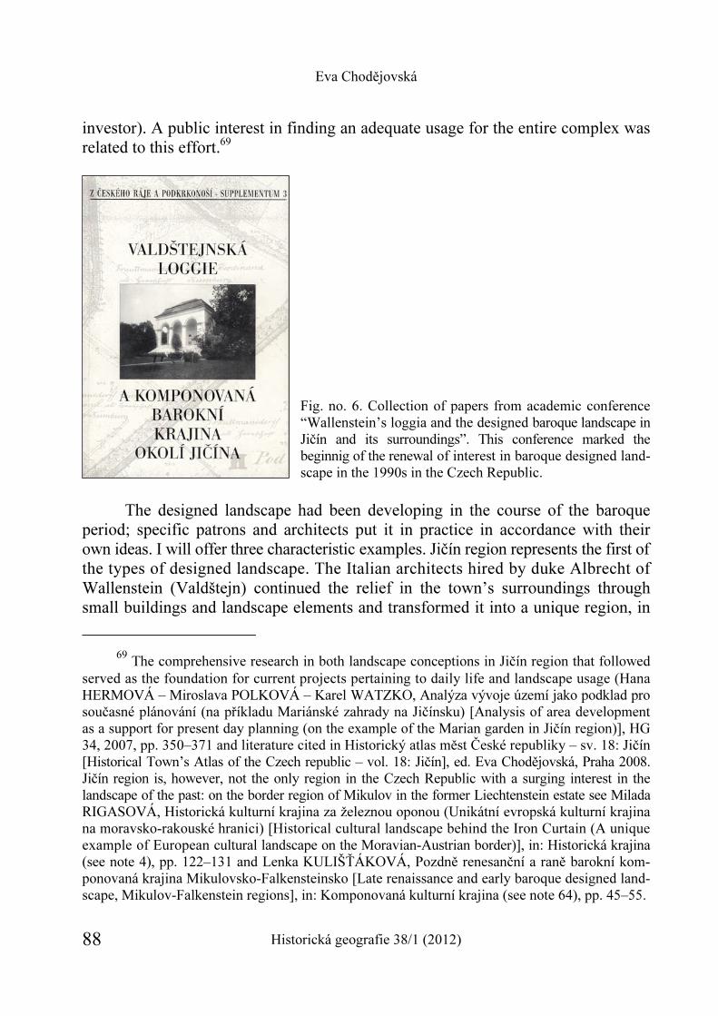
Eva Chodějovská
Historická geografie 38/1 (2012) 88
investor). A public interest in finding an adequate usage for the entire complex was related to this effort.69
Fig. no. 6. Collection of papers from academic conference “Wallenstein’s loggia and the designed baroque landscape in Jičín and its surroundings”. This conference marked the beginnig of the renewal of interest in baroque designed land-scape in the 1990s in the Czech Republic.
The designed landscape had been developing in the course of the baroque
period; specific patrons and architects put it in practice in accordance with their own ideas. I will offer three characteristic examples. Jičín region represents the first of the types of designed landscape. The Italian architects hired by duke Albrecht of Wallenstein (Valdštejn) continued the relief in the town’s surroundings through small buildings and landscape elements and transformed it into a unique region, in
69 The comprehensive research in both landscape conceptions in Jičín region that followed
served as the foundation for current projects pertaining to daily life and landscape usage (Hana HERMOVÁ – Miroslava POLKOVÁ – Karel WATZKO, Analýza vývoje území jako podklad pro současné plánování (na příkladu Mariánské zahrady na Jičínsku) [Analysis of area development as a support for present day planning (on the example of the Marian garden in Jičín region)], HG 34, 2007, pp. 350–371 and literature cited in Historický atlas měst České republiky – sv. 18: Jičín [Historical Town’s Atlas of the Czech republic – vol. 18: Jičín], ed. Eva Chodějovská, Praha 2008. Jičín region is, however, not the only region in the Czech Republic with a surging interest in the landscape of the past: on the border region of Mikulov in the former Liechtenstein estate see Milada RIGASOVÁ, Historická kulturní krajina za železnou oponou (Unikátní evropská kulturní krajina na moravsko-rakouské hranici) [Historical cultural landscape behind the Iron Curtain (A unique example of European cultural landscape on the Moravian-Austrian border)], in: Historická krajina (see note 4), pp. 122–131 and Lenka KULIŠŤÁKOVÁ, Pozdně renesanční a raně barokní kom-ponovaná krajina Mikulovsko-Falkensteinsko [Late renaissance and early baroque designed land-scape, Mikulov-Falkenstein regions], in: Komponovaná kulturní krajina (see note 64), pp. 45–55.
Studying the Early Modern Landscape in the Czech Republic
Historická geografie 38/1 (2012) 89
which the town was connected to its surrounding areas by exact geometrical relation-ships based on astronomical calculations. In doing so, they drew on their knowledge of towns in the Italian renaissance and in the early modern period.70 The landscape of Jičín’s surrounding areas from the 1630s was thus quite unique, ahead of its time compared to the rest of the Czech lands. However, the much needed care of the landscape composition declined with the death of its ideological creator.
Much later, not until the first third of the 18th century, Jičín was followed by other baroque landscape compositions in the Czech lands. The surrounding of Lysá nad Labem and the Kuks complex – the estate of František Antonín Špork – reveal an effort at dynastic self-representation infused with baroque spirituality and create a dignified space for the entertainment of the patron, who gave free range to the most illustrious artists of his time.71 The third type of designed landscape, the least forceful one, can be found also in the Jičín region – this time its southern part, which after 1637 belonged to the Schlik family. The designed landscape in the conception of František Josef Schlik and his wife offered a sensitive subtle finish to the land-scape, which enriched it not only on the aesthetic but also on the spiritual level (with
70 Besides the collection cited here and the study by Jan Hendrych and Michaela Líčeníková in the note 68 and by Pavel Hájek (see notes 58 and 67) see Academic atlas (see note 31) and Historical Town’s Atlas of the Czech republic – vol. 18: Jičín (see note 69); in the present day, an on-going research project Architektura, urbanismus a krajinotvorba frýdlantského panství Albrechta z Valdštejna (1621–1634) [Architecture, urbanism and landscape-management on the Frýdlant estate of Albrecht of Wallenstein (Valdštejn) (1621–1634)] under the leadership of Petr Uličný; it has produced first publications, published in journal Umění [Art] (see www.vevodstvi.cz/).
71 Recent studies of designed landscape in the vicinity of Lysá nad Labem and Kuks by Jan HENDRYCH, Krajina bývalého nadačního panství Choustníkovo Hradiště, její příběh, proměny a souvislosti; péče o historickou krajinu světového významu [The landscape of the former estate in Choustníkovo Hradiště, its tale, transformations and context], ZPP 68, 2008, pp. 302–308; Oldřich VAŇURA, Šporkův Kuks 1. poloviny 18. století [Špork’s Kuks of the first half of the 18th century], Sborník Národního památkového ústavu, územního odborného pracoviště v Pardubicích za rok 2007, 2008, pp. 54–58; monograph by J. KAŠE – P. KOTLÍK, Braunův Betlém (see note 58) and Eva SEMOTANOVÁ, Vogtova veduta Lysé nad Labem – „naučná stezka“ Šporkovou barokní krajinou [Vogt’s vedute of Lysá nad Labem – “nature path” through Špork’s baroque landscape], in: Od knížat ke králům. Sborník u příležitosti 60. narozenin Josefa Žemličky [From dukes to kings. A collection on the occasion of Josef Žemlička’s 60th birthday], edd. Eva Dole-žalová – Robert Šimůnek, Praha 2007, pp. 494–514 and EADEM, Česká barokní krajina [Bohemian baroque landscape], in: Academic atlas (see note 31). On the Špork personality and partonage activities see most recently Pavel PREISS, František Antonín Špork a barokní kultura v Čechách [František Antonín Špork and the baroque landscape in Bohemia], Praha – Litomyšl 22003 and the proceedings from the conference „Barokní úředník a jeho šlechtic. Tobiáš Antonín Seeman, František Antonín Špork a jeho dědicové v polovině 18. století“ [“A baroque official and his nobleman. Tobiáš Antonín Seeman, František Antonín Špork and their heirs in the mid-18th century”] that took place in Pardubice on May 26th – 28th 2011, forthcoming.
Eva Chodějovská
Historická geografie 38/1 (2012) 90
a full awareness of the need to make some economic use of the landscape as well, attested by the new construction of baroque granaries in Vokšice a Střevač); this is not an interference from the position of power nor is it a demonstration of one’s own power and standing, but an expression of devotion of the baroque man. By introducing small sacral architecture from the studio of Jean Baptist Mathey on selected hilltop of the rugged landscape, they underscored a landscape composition in the shape of a cross, whose shoulders intersected in the loretto chapel on the hillside of the same name on the Veliš ridge, and by its consecration expressed their devotion to the Blessed Virgin Mary.72 The phenomenon of transforming a landscape
72 Jaromír GOTTLIEB, Zahrada mariánská [Marian garden], in: Tvář naší země – krajina domova 3. Duchovní (see note 58), pp. 31–45; essays in the collection Valdštejnovo město Jičín. Minulost – budoucnost [Wallenstein’s town Jičín. History – future], Knihovnička Regionálního muzea galerie v Jičíně, sv. 1 = Sborník referátů z konference konané v Jičíně 10. 10. 2001 [A con-ference proceedings from October 10th 2001 in Jičín], Jičín 2006; and also Lucie RYCHNOVÁ, Filip Spannbrucker – ke vztahu stavitele a stavebníka v době vrcholného baroka [Filip Spannbrucker – on the relationship between an architect and a builder in the high baroque period], Z Českého ráje a Podkrkonoší 23, 2010, pp. 31–52 and literature cited in notes 66–70.
Studying the Early Modern Landscape in the Czech Republic
Historická geografie 38/1 (2012) 91
above and beyond the usual extent of a noble residence guided by esthetic and spiritual motivations continued in the Czech lands until the early 19th century.73
73 The designed landscape on the Buquoy estate Nové Hrady in southern Bohemia is currently studied by Martin Krummholz and Petra Trnková in the Institute of Art History, Academy of Sciences of the Czech Republic: project Obnova buquoyské kulturní krajiny. Záchrana movitého kulturního dědictví jako báze pro obnovu paměti místa a kulturní identity [A renewal of Buquoy’s cultural landscape. Preservation of material cultural heritage as the bases for renewal of place and of cultural identity] is scheduled for 2011–2015.
Eva Chodějovská
Historická geografie 38/1 (2012) 92
Designed landscape is one of the types of historical cultural landscape, which by law can become the object of protection in the Czech Republic, especially because it “documents the life in the country and its economy, the development from pre-history to the present, or is connected with life and economy of towns from the earliest periods through the development of manufacture and industry. Other [his-torical cultural landscapes] are connected with historical landscapes, memorials or their clusters”.74 With regard to “early modern landscapes” in the Czech Republic, the assessment of the role of pilgrimage areas in the historical landscape75 is still in its early stages; there is also some peripheral interest in the study of regions whose landscape had been majorly transformed in the course of the baroque period owing to the impact not of the secular but of the ecclesiastical hierarchy, where expressions
74 Jan HENDRYCH, Krajina kulturní a historická [Cultural and historical landscape], ZPP
58, 1998, pp. 73–75, here p. 74. On the subject of legislature see (selectively) Jan HENDRYCH, Historická kulturní krajina – současný stav a potřeba zákonné ochrany a péče [Historical cultural landscape – current situation and the need for legal protection and care], in: Tvář naší země – krajina domova 2. Krajina jako kulturní prostor [Face of our land – the face of home 2. Land-scape as a cultural space], Lomnice nad Popelkou 2002, pp. 17–21; Olga BAŠEOVÁ, Bu-doucnost krajinných památkových zón [The future of landscape preservation areas], in: Tvář naší země – krajina domova 6. Rehabilitace krajiny [Face of our land – the face of home 6. Rehabilitation of landscape], Lomnice nad Popelkou 2002, pp. 63–67; for essays devoted specifi-cally to this question see the conference proceedings from the 2nd conference that took place on October 8th – 11th 2002 at the Prague Castle and in Průhonice: Tvář naší země – krajina domova 5. Ochrana krajiny [The face of our land – the face of home 5. Protection of landscape], Lomnice nad Popelkou 2002. Also Věra KUČOVÁ – Karel KUČA, Ochrana kulturní krajiny v České republice a její perspektivy [The protection of the cultural landscape in the Czech Republic and its perspectives], Památková péče na Moravě 10, 2005, pp. 7–24; Věra KUČOVÁ, Kulturní krajina a krajinné památkové zóny v České republice v kontextu světového kulturního a pří-rodního dědictví [Cultural landscape and landscape protection zones in the Czech Republic in the context of the world’s cultural and natural heritage], ZPP 68, 2008, pp. 295–301 and Jiří KUPKA, Historická krajina a institut krajinného rázu. Možnosti ochrany dochovaných znaků historické krajiny formou ochrany krajinného rázu dle § 12 zákona 114/1992 Sb. o ochraně přírody a krajiny [Historical landscape and the landscape character. Possibilities of protection of the remaining landmarks of the historical landscape according to § 12 law 114/1992 Sb. about the protection of nature and landscape], HG 35, 2009, pp. 7–26; see other publications especially on the subject of landscape character by this author and his colleagues from the studio of Ivan Vorel.
75 For example, see the contributions in the collection edited by Pavla STUCHLÁ, 300 let poutního kostela Jména Panny Marie na Lomci. Sborník příspěvků z odborného semináře kona-ného dne 14. 9. 2004 v Městské galerii ve Vodňanech u příležitosti kulatého výročí vysvěcení chrámu [300 years of the pilgrimage church of the Blessed Virgin Mary in Lomec. A collection of contributions from an academic seminar that took place on September 14th 2004 in the City’s gallery in Vodňany on the occassion of the 300 anniversary of the church’s consecration], Vodňany 2005, the pilgrimage site Kájov has long been studied by Zdeňka Prokopová. See also note 84.
Studying the Early Modern Landscape in the Czech Republic
Historická geografie 38/1 (2012) 93
of self-representation and spiritual display mixed with the practical necessity to manage its own estate (Broumov region, Plasy).76
76 In addition to works by Irena Bukačová (see for example study cited in note 56), Petr
ROŽMBERSKÝ, Dvory plaských cisterciáků [Farms of the Cistercians in Plasy], Plzeň 1999 or the contributions in the collection of essays on the occasion of the 850th anniversary of the monastery in Plasy (1145–1995). A collection of contributions from a seminar Vývoj a význam plaského kláštera pro české dějiny [The development and significance of the monastery in Plasy for Czech history] that took place in Mariánská Týnice between May 31st and June 2nd 1995, ed. Jiří Fák, Mariánská Týnice 1995; also, for example Petr PETŘIVALSKÝ, Kapucínská krajina [Capuchin landscape], HG 36, 2010, pp. 147–149 and in Broumov region, which had been shaped by Benedictines from Břevnov, for information on the landscape, small memorials and baroque sacral architecture, see Broumovská skupina kostelů Kryštofa a Kiliána Ignáce Dientzenhofera [Broumov’s group of churches by Kryštof and Kilián Ignác Dientzenhofer], ed. Mojmír Poláček, Brno 2000, but also the database of memorials put together by the project entitled Zapadlými cestami minulosti [Through the remote paths of history] http://www.collegium.cz/index.php?menu=broumovsko/ zapcest&page=uvod and most recently Bohumír PROKOP – Jiří T. KOTALÍK – Pavel SŮVA, Brou-movská skupina kostelů. Průvodce školou českého baroka v kraji pískovcových skal [Broumov’s group of churches. A guidebook through the school of the Bohemian baroque in the sandstone rock region], Vernéřovice 2007.
Eva Chodějovská
Historická geografie 38/1 (2012) 94
In contrast, the question of castle parks77 has been newly discovered for re-search – the first phase in the form of lucid evidence – by academics in the field of garden architecture.78 The development of townscape in the early modern period has not been generally assessed.79 The interest of academics and of laymen alike has been focused especially on the landscape in the countryside, in regards to evidence, description of details and sometimes actual preservation of the so-called small memo-rials. The artistic value of these primarily high and late baroque (as well as more recent) chapels, statues, statuary, crosses, wayside shrines etc. is very diverse. How-ever, they have a crucial role in completing the character of the “Bohemian baroque landscape”, and they give evidence about the nature of the co-existence between man and his landscape.80 Marian and Holy Trinity columns have been listed – as a part of an effort to record such memorials – by the National Heritage Institute,81 and art historians have dedicated several crucial studies to statuaries in landscape.82 In
77 Markéta ŠANTRŮČKOVÁ – Věra VÁVROVÁ, Databáze historických zahrad, parků a kra-
jiny, její vznik a parametry [A database of historical gardens, parks and landscape, its origins and parameters] [online] 2008, accessible at : <http://knihovna.nkp.cz/knihovnaplus81/santruc. htm>.
78 See especially works by Jan HENDRYCH – Božena PACÁKOVÁ-HOŠŤÁLKOVÁ et al., Zahrady a parky v Čechách, na Moravě a ve Slezsku [Gardens and parks in Bohemia, Moravia and Silesia], Praha 2004; IIDEM et al., Pražské zahrady a parky [Prague’s gardens and parks], Praha 2000 and Sylva DOBALOVÁ, Zahrady Rudolfa II. Jejich vznik a vývoj [Gardens of Rudolph II. Their origin and development], Praha 2009.
79 For (an attempted) typology of towns in the early modern period in the Czech lands, see Petr VOREL, Rezidenční vrchnostenská města v Čechách a na Moravě v 15.–17. století [Residential noble towns in Bohemia and Moravia between the 15th and 17th century], Pardubice 2001; on one of the main types of towns newly-founded in the Czech lands in the baroque period, see works by V. Kupka, for example Vladimír KUPKA et al., Pevnosti a opevnění v Čechách, na Moravě a ve Slezsku [Walls and fortifications in Bohemia, Moravia and Silesia], Praha 22002. Additional up-to-date literature is listed in individual volumes of Hisctorical Town’s Atlas.
80 Irena BUKAČOVÁ – Tomáš HÁJEK, Příběh drobných památek. Od nezájmu až k fasci-naci [A tale of small memorials. From disinterest to fascination], Lomnice nad Popelkou 2001 and the series Paměť krajiny [Memory of the landscape] by Irena Bukačová and Jiří Fák, which lists small memorials in the Plzeň region (individual volumes have been published since 2006, with 7 published volumes so far).
81 Petr GLÁSER – Vratislav NEJEDLÝ, Soupisy mariánských, trojičních a dalších sloupů a pilířů v českých zemích [Lists of Marian, Trinitarian and other columns and pillars in the Czech lands], ZPP 70, 2010, 1, p. 59.
82 For example the estate Manětín-Rabštejn; on the Cítoliby estate of the Pachta dukes of Rájov, see: Martin EBEL – Pavel VLČEK, Zámecká zahrada v Cítolibech [The castle garden in Cítoliby], Průzkumy památek 2, 1995, no. 2, pp. 23–30; Bohumír ROEDL, Cítoliby [Cítoliby], Louny
Studying the Early Modern Landscape in the Czech Republic
Historická geografie 38/1 (2012) 95
addition to architectural objects and urban ensembles, attention is also given to individual landscape elements83 including roads; the systematic research of road construction undertaken by František Roubík had not been fully completed.84
Currently, there are several trends in the landscape research in the 17th and 18th centuries in the Czech lands; some of them intersect with each other or become
2003. In general terms, Pavel SUCHÁNEK, Barokní sochy v krajině a hledání jejich významu [Baroque statues in landscape and search for their meaning], SPFFBU – F 55, 2006, 50, pp. 81–96.
83 Igor KYSELKA, Význam drobných krajinných prvků, zkušenosti s jejich obnovou u nás i v zahraničí [The importance of smaller landscape elements, experience with their renewal here and abroad], in: Tvář naší země – krajina domova 2. Krajina (see note 74), pp. 29–34; also for example Miloslav VYSLOUŽIL, Historické aleje – cesty do historických zahrad [Historical tree avenues – paths into historical gardens], in: Historické zahrady Kroměříž 2006. Umění a společenská čin-nost v historických zahradách. Sborník vydaný u příležitosti konání odborného semináře ve dnech 8.–10. 6. 2006 v Kroměříži [Historical gardens Kroměříž 2006. Art and social activities in historical gardens. A collection published on the occasion of an academic seminar on June 8th – 10th 2006 in Kroměříž], Hrdějovice 2006, pp. 41–43; Historie a současnost alejí v krajině a urbanizovaném prostředí. Sborník přednášek z odborného semináře konaného v Olomouci ve dnech 17.–18. 9. 2007 [History and the present of tree alleys in the landscape and in urbanized environment. A collection published on the occasion of an academic seminar on September 17th – 18th 2007 in Olomouc], Olomouc 2007; Libuše SEDLÁČKOVÁ, Aleje a obory – významné krajinné útvary [Tree alleys and enclosures – important landscape elements], Památková péče na Moravě 10, 2005, pp. 75–84.
84 František ROUBÍK, Silnice v Čechách a jejich vývoj [Roads in Bohemia and their develop-ment], Praha 1938 and other unpublished manuscripts kept at the Postal museum and in the collection František Roubík in the Archive of the Academy of Sciences of the Czech Republic. Special attention is given to pilgrimage routes (Eva SEMOTANOVÁ – Jiří MIKULEC, Via sancta – poutní cesta z Prahy do Staré Boleslavi [Via sancta – the pilgrimage route from Prague to Stará Boleslav], in: Academic atlas (see note 31); on the same route with a French abstract: Marie-Elisabeth DUCREUX, Symbolický rozměr poutě do Staré Boleslavi [The symbolic dimension of the pilgrimate to Stará Boleslav], ČČH 95, 1997, pp. 585–620; Eva SEMOTANOVÁ, Poutní cesta do kladských Vam-beřic [The pilgrimage route to Vambeřice in Kladsko region], in: Academic atlas (see note 31); Jan ČERNOHLÁVEK, Poutní cesta Brno Královo Pole přes Soběšice a Útěchov na Vranov [The pilgrimage route Brno Královo Pole through Soběšice and Útěchov to Vranov], Staré stezky 12, 2008, pp. 25–52; Kateřina PAŘÍZKOVÁ, Barokní poutní cesta do Hájku u Prahy [Baroque pilgrimage route to Hájek near Prague], FHB 25, 2010, no. 2, pp. 113–153 and Eva CHO-DĚJOVSKÁ, Praha křižovatkou cest [Prague, the crossroads], in: Ottův atlas Prahy [Otto’s atlas of Prague], forthcoming.) The journal Staré stezky [Ancient paths] publishes studies on the road network, but most of the contributions address older periods. An exception, aside from the above mentioned, is Dušan ADAM, I. vojenské mapování. Informační zdroj pro výzkum starých cest [The 1st military survey as a source of information for research in old roads], Staré stezky 9, 2004, pp. 9–19, who published other contributions elsewhere, here for example papers cited in note 55. See also the study by I. BUKAČOVÁ, Cesta (see note 56).
Eva Chodějovská
Historická geografie 38/1 (2012) 96
Studying the Early Modern Landscape in the Czech Republic
Historická geografie 38/1 (2012) 97
combined, at other times their authors remain in opposition with each other. The majority of the works on early modern landscape in the Czech lands from the last twenty years is characterized by an effort for interdisciplinary cooperation among authors or at least for using sources and resources of more than one discipline at a given time. There are a number of seminars and conferences on the subject of his-torical landscape, described elsewhere in this volume, and they add to the mutual awareness and cooperation. In light of the above-mentioned level of academic interest in historical landscape of the Czech lands in the early modern period, several re-search approaches have emerged: of natural environment in history,85 of history and historical geography,86 of philosophy87 and culturology,88 of art history,89 of preserva-tion,90 of garden architecture,91 and of archeology.92 If academic interest in this long-
85 Rudolf Brázdil, Jan Munzar. 86 Eva Semotanová. 87 Václav Cílek, Miloš Šejn. 88 Pavel Hájek. 89 Mojmír Horyna. 90 Irena Bukačová, listing initiatives of the National Heritage Institute as well as of various
volunteer groups. 91 Jan Hendrych, Markéta Šantrůčková. 92 Individual analyses remain the result of the research thus far. The working group, under
the leadership of Václav Matoušek, one of the representatives of the early modern archeology, does not limit itself only to material sources, but uses especially iconographic material as well. (See note 49.) Most recent monograph by Václav MATOUŠEK, Třebel. Obraz krajiny s bitvou [Třebel. The image of landscape with a battle], Praha 2006. Modern archeological (non-destructive) methods, such as air archeology, have a lot to offer to research in early modern landscape. Among the pioneers in the Czech Republic is especially Martin Gojda (see Martin GOJDA, Archeologie kra-jiny [The archeology of landscape], Praha 2000 and Nedestruktivní archeologie [Non-destructive archeology], ed. Martin Kuna, Praha 2004, and especially Martin GOJDA, Vývojové trendy dálkového průzkumu v archeologii střední Evropy [Development trends of remote research in archeology of central Europe], in: Studie k dálkovému průzkumu v archeologii [Contributions to remote research in archeology], ed. Martin Gojda, Plzeň 2010, pp. 8–12 and also Ladislav ŠMEJDA, Mapování archeologického potenciálu pomocí leteckých snímků [Mapping archeological potential using airphotos], Plzeň 2009. Among other modern methods, there is application of multi-spectral and later hyper-spectral photography using so-called LIDARs (Light Detection and Ranging) etc.: Tomáš DOLANSKÝ, Lidary a letecké laserové skenování [LIDARs and air laser scanning] = AUP 99, 2004 (a monographic volume); Martin GOJDA, Lidar a jeho možnosti ve výzkumu historické krajiny [LIDAR and its potential in research in historical landscape], AR 57, 2005, pp. 806–809 and report about project Potenciál archeologického výzkumu krajiny v ČR prostřednictvím dálko-vého laserového 3-D snímkování (LIDAR) [Potential of archeological research of landscape in the
Eva Chodějovská
Historická geografie 38/1 (2012) 98
ignored subject continues, the moment is not far off when a synthetic work on the landscape of the early modern period in the Czech lands can be published.93
Eva Chodějovská Zkoumání krajiny raného novověku v České republice Studie podává přehled o výzkumu kulturní krajiny dnešní České republiky v období raného novověku (16.–18. století), který byl na území ČR, resp. Československa realizován od konce 19. století do současnosti. Jsou zde shrnuty nejvýznamnější knihy, studie, inter-netové zdroje z celého spektra humanitních, přírodovědných i technických disciplín. Po krátkém úvodu, kde jsou stručně popsány hlavní trendy vývoje krajiny Českých zemí ve sledovaném období, přináší první část studie přehled edic kartografických i ikonografic-kých pramenů pro poznání této krajiny a rekapituluje moderní – digitální možnosti zpří-stupnění těchto pramenů. Ve druhé části autorka sleduje vývoj vědeckého zájmu o raně novověkou krajinu českých zemí jako takovou. Moderní studium krajiny navazuje na historickou vlastivědu (pěstovanou zejména J. V. Šimákem a F. Roubíkem) a na umě-leckohistorický směr, kdy v centru pozornosti stála historická barokní (komponovaná) kra-jina (Z. Wirth). V rámci současného, většinou mezioborově pojatého studia krajiny v České republice můžeme vypozorovat několik badatelských směrů (směr studující přírodní prostředí v minulosti, směr historický či historicko-geografický, filozofický a kulturolo-gický, uměleckohistorický, památkářský, zahradně-architektonický a archeologický), u nichž autorka uvádí hlavní představitele. Impulzy tomuto vědeckému zájmu o krajinu dodávají také četné občanské iniciativy, ekologická hnutí či soukromé nadace, které mj. shromaž-ďují data a vydávají historicky zaměřené publikace.
Czech Republic using remote laser 3-D scanning (LIDAR)]: Martin GOJDA – Jan JOHN – Lenka STARKOVÁ, Dálkový archeologický průzkum a 3D mapování krajiny pomocí lidaru. Dosavadní průběh a výsledky prvního českého projektu [Remote archeological research and 3-D landscape mapping using LIDAR. Existing research and the results of the first Czech project], AR 63, 2011, pp. 680–698.
93 For the most lucid summary of the transformations of the Czech landscape in the baroque period and contemporary interest in it see, E. SEMOTANOVÁ, Historická geografie (see note 2). The main phenomena have been described and discussed from the point of view of a culturo-logist, climatologist, and botanist by the authors of Krajina a revoluce [Landscape and revolu-tion], which is dedicated to the transformations of the cultural landscape in the Czech lands from the prehistoric era to the present day. Jiří SÁDLO et al., Krajina a revoluce: významné přelomy ve vývoji kulturní krajiny Českých zemí [Landscape and revolution: important turning points in the development of the cultural landscape in the Czech Republic], Praha 32008 (for the early modern period, see pp. 177nn), critiqued, however, by Eduard MAUR, Revoluce ve výkladu his-torických proměn krajiny? [Revolution in the interpretation of the historical changes of land-scape?], ČČH 105, 2007, pp. 619–626.
HISTORICKÁ GEOGRAFIE 38/1 (2012)
http://www.hiu.cas.cz/cs/mapova-sbirka/historicka-geografie.ep/
99
Markéta Šantrůčková*
THE PRINCIPLES AND DEVELOPMENT OF LANDSCAPE PARKS IN THE CZECH REPUBLIC
AND THEIR STUDY FROM THE PERSPECTIVE OF HISTORICAL GEOGRAPHY
Keywords
Abstract
landscape park designed landscape historical geography Czech lands
This paper presents landscape parks as objects of re-search in historical geography, a main advantage of which is its synthetic approach to the study of land-scape parks as opposed to the more singular approaches of other sciences that also deal with parks (e.g. dendro-logy, garden architecture, art history, and biology). It focuses on landscape design and construction principles and their links to the natural and sociocultural environ-ment. It interprets the societal impulses and inspira-tional bases that led to the expansion of the land-scape park fashion, as well as the design basics that define their appearance. It also deals with the con-temporary significance of landscape parks and the possibilities for their preservation and restoration. It outlines methods for studying landscape parks.
* PhDr. Markéta Šantrůčková, Ph.D., Department of Physical Geography and Geoecology,
Faculty of Science, Charles University in Prague, Albertov 6, Praha 2, CZ – 128 43, and the Silva Tarouca Research Institute for Landscape and Ornamental Gardening, Květnové náměstí 391, Průhonice, CZ – 252 43. E-mail: [email protected] – This paper was written as part of research plan MZP0002707301 Research of non-producer plants and their utilization in the landscape and settlements in the future and Specific Tertiary Education Research project 2011 – 263202 and Grant Agency of the Czech Republic No. P410/12/G113 and project DF12P01OVV016 Evaluation and sustainable development of the garden art monuments.
Markéta Šantrůčková
Historická geografie 38/1 (2012) 100
Introduction
Landscape parks are a specific object of study. Garden and landscape architecture deal with them the most frequently, focusing of course on their vegetation and compositional components. Landscape parks, however, are also relevant objects for geographical research. They are an integral part of the landscape sphere, in which the influences of the natural environment and its anthropogenic changes inseparably intersect in a specific way. The natural environment contributes to the appearance of landscape parks significantly through various forms of relief. At the same time topography is not taken passively to be a base for establishing parks, but it is actively modified at great cost and effort. Other steps in the creation of parks were closely connected to land forming, such as the design and modification of water features, vegetation planting and modeling, and the compositional arrangement of the park. Landscaping in landscape parks is special because these changes, though distinctive, were supposed to remain hidden from the observer and were supposed to simulate natural lines and shapes.1
For geography, landscape parks are exceptional areas and bring forth inte-resting research questions. Whereas vegetation and dendrological composition and compositional arrangement are the domain of garden architecture, the role of geo-graphy is to evaluate the influence of the natural environment and the extent of its anthropogenic changes. Geographic research questions in landscape parks are focused on the extent of utilizing and transforming the natural topography and its influence on the appearance and creation of parks, i.e. on studying the mutual interaction of how the natural environment influences the appearance and impression of certain parks, and on the other hand how they were influenced. Another area of study is the relationship between landscape parks and their surroundings. Parks should be con-nected to the surrounding, predominantly agricultural or forest, landscape, and should naturally communicate with them, that is they often co-defined the functional arrange-ment of the landscape, just as they conform to it.2 The study of landscape parks can thus be included in the broad movement of “post-modern” historical geography and
1 S. LANG, The Genesis of the English Landscape Garden, in: The Picturesque Garden and
Its Influence outside the British Isles, ed. Nicolaus Pevsner, Washington 1974, pp. 1–29. 2 Markéta ŠANTRŮČKOVÁ – Věra VÁVROVÁ – Martin WEBER – Lenka STROB-
LOVÁ, Proměny vztahu města a krajiny na příkladu Nových Dvorů na Kutnohorsku [Changes in the Relation Between Town and the Landscape presented on the Example of Nové Dvory in the Kutná Hora region], HG 37, 2011, pp. 87–110.
The Principles and Development of Landscape Parks in the Czech Republic
Historická geografie 38/1 (2012) 101
research into the interaction of culture/society with landscape/environment.3 The aim of this paper is to present ideas, principles, and approaches to creating landscape parks that determine their appearance, and topographical and landscape connections. Further a brief overview of methods in which historical and geographical approaches narrowly intersect will be given.
Ideas and inspiration for the development and creation of landscape parks
The landscape style was developed on the British Isles in the 18th century, during the second half of which this style began to spread to continental Europe. Its perception in France and in the German-speaking lands was important for further development as European landscape parks were enriched with peculiar elements there. This free landscape style remained popular in Europe throughout the entire 19th century with certain changes, considering its long existence. What ideas and sources of inspiration led to the transformation of gardens from formal and architectonically complicated baroque gardens and parks to the freer landscape style? There was a concurrence of several influences that mutually intertwined and affected individual architects with various intensities in different time periods.4
Valuing nature in society has always been narrowly reflected in garden and park design. The path to recognizing natural beauty and nature as a whole was gradual. The concept of Paradise (via the Paradise garden) played an important role, mainly in the Middle Ages but also well into the modern era. Individual natural objects (such as flowers) were considered to be pretty, as well as beautiful places often in the form of gardens. The cultivated landscape was valued more and more, especially beginning in the Renaissance.5 The perception of the landscape as a whole and its aesthetic qualities became established in the 17th and 18th centuries.6 A. A.
3 Pavel CHROMÝ – Leoš JELEČEK, Tři alternativní koncepce historické geografie
v Česku [Three Alternative Conceptions of Czech Historical Geography], HG 33, 2005, pp. 327–345.
4 Norman NEWTON, Design of the Land. The Development of Landscape Architecture, Cambridge – London 1971.
5 Josef MACEK, Vnímání přírodních krás v českých zemích pozdního středověku [The Perception of Natural Beauty in the Late-Medieval Czech Lands], ČČH 95, 1997, pp. 289–314; Denis COSGROVE, Geography and Vision, London – New York 2008.
6 Karel K. STIBRAL, Proč je příroda krásná? Estetické vnímání přírody v novověku [Why is Nature Beautiful? The Aesthetic Perception of Nature], Praha 2005; Karel STIBRAL – Stanislav KOMÁREK, Význam přírodních věd pro estetické vnímání přírody [The Importance of
Markéta Šantrůčková
Historická geografie 38/1 (2012) 102
Cooper, the Earl of Shaftesbury, was one of the first to admire nature for its own sake and was at the beginning of attempts to artistically shape the landscape.7 The many English philosophers, poets, artists, and gardeners who followed Shaftesbury’s ideas, formed the principles of landscape parks. J. Addison accentuated the beauty of natural forms and conceived gardens as pictures in many of his writings. The poet A. Pope, not only further developed Shaftesbury’s and Addison’s ideas, but also put them into practice, as following them he began to construct a park that he composed as a scene – as a picture. Pope defined the basics of the landscape park, which included the contrast between individual features and a connection to the surrounding landscape.8 Besides English philosophers and artists the ideas of J. J. Rousseau, I. Kant, and C. C. L. Hirschfeld in particular influenced landscape perception on the continent as well as the appearance of European landscape parks. Rousseau’s rejection of society and civilization as flawed and bad and his glorification of nature were widely received. For Rousseau nature was good and beautiful; it was a refuge where a person could be all alone.9 This conception resonated with infant Romanti-cism and contributed to the further expansion of the landscape park fashion, which was supposed to embody ideal, uncorrupted nature.10 In German areas English and French influences were absorbed. In Kritik der Urteilskraft Kant rejects the earlier notion of equating beauty with geometric relationships and in contrast puts natural beauty on the highest level. In Theorie der Gartenkunst C. C. L. Hirschfeld systemati-cally summarizes current experience with creating landscape parks. He classified parks and parts of parks as being merry, melancholic, romantic, and sublime and for each type proposed various buildings and scenery. He emphasized that a gardener should be inspired by nature, but at the same time should hide or re-form less favor-
the Natural Sciences for the Modern Perception of Nature], Dějiny vědy a techniky 37, 2004, pp. 65–76.
7 K. STIBRAL, Proč je příroda krásná (see note 6), pp. 62–65; Karel STIBRAL, Darwin a estetika [Darwin and Aesthetics], Červený Kostelec 2006; Otakar KUČA, Zur Entwicklung der europäischen Park- und Gartenlandschaft. Ein Beitrag zur Theorie und Geschichte des Landschafts-baus, Berlin – Charlottenburg 1974.
8 Hanno Walter KRUFT, Dějiny teórie architektúry od antiky po súčasnosť [The History of Architectural Theory from Classical Times to Today] (Geschichte der Architekturtheorie: Von der Antike bis zur Gegenwart), Bratislava 1993; Pavel VLČEK, Ilustrovaná encyklopedie českých zámků [An Illustrated Encyclopedia of Czech Castles], Praha 1999; Ondřej ZATLOUKAL, Et in Arcadia Ego, Olomouc 2004; Bohumil KAVKA et al., Krajinářské sadovnictví [Landscape Manage-ment], Praha 1970; Marie Luise GOTHEIN, Geschichte der Gartenkunst, Jena 1926.
9 K. STIBRAL, Proč je příroda krásná (see note 6), pp. 74–79; O. ZATLOUKAL, Et in Arcadia Ego (see note 8), p. 74.
10 Frank CLARK, The English Landscape Garden, Gloucester 1980.
The Principles and Development of Landscape Parks in the Czech Republic
Historická geografie 38/1 (2012) 103
able features.11 Three aesthetic categories were discussed in particular in connection with early landscape parks – beauty, the sublime, and above all the picturesque. Thanks to the relatively close connections between landscaping and painting, the term picturesque was transferred to landscape and garden perception. The picturesque expressed the quality of the landscape; the overall effect and perception of landscape/ parks/gardens was emphasized. Individual components and objects were evaluated based on their working within the whole.12
Another important impulse for the development of landscape parks was 17th
and 18th century painting, which depicted free landscapes at a time when gardens were still ruled by geometric principles.13 Northern Italian and Dutch landscape painting in particular became an inspirational model. Whereas the Dutch portrayed realistic landscapes on their canvases, painters influenced by the Italian model pre-ferred the ideal landscape of mythical Arcadia.14 The landscape park itself was con-ceived as a painting; gardens were created as three-dimensional pictures, where mutual relationships between individual features played a critical role.15 Contemporary and classical literature was considered important for the appearance of landscape parks, as parks often referenced them.16 A walk through such a park was usually a thoughtfully conceived journey between various types of scenery, where a visitor
11 H. W. KRUFT, Dějiny (see note 8), pp. 293–295; P. VLČEK, Ilustrovaná encyklopedie
(see note 8), p. 151. 12 O. ZATLOUKAL, Et in Arcadia Ego (see note 8), p. 72; K. STIBRAL, Darwin (see note
7), pp. 93–94; John Dixon HUNT, “Ut Pictura Poesis”. The Garden and the Picturesque in England, in: The History of Garden Design, edd. Monique Mosser – Georges Teyssot, London 1991, pp. 231–241; Vlasta DVOŘÁKOVÁ, K sémantice sentimentálních zahrad [On the Semantics of Romantic Gardens], in: Člověk a příroda v novodobé české kultuře [Man and Nature in Modern-Era Czech Culture], ed. Milena Freimanová, Praha 1989, pp. 147–166.
13 Otakar KUČA, Malířství a genese krajinářské architektury [Painting and the Develop-ment of Landscaping], in: Kompozice zahrad v dějinách umění [Garden Composition in Art History], Tábor 1987, pp. 12–18.
14 O. ZATLOUKAL, Et in Arcadia Ego (see note 8), p. 66; K. STIBRAL, Proč je příroda krásná (see note 6), pp. 44–56.
15 V. DVOŘÁKOVÁ, K sémantice (see note 12), p. 158; B. KAVKA et al., Krajinářské sa-dovnictví (see note 8), p. 244–245; O. KUČA, Zur Entwicklung (see note 7), p. 55; Jaroslav HORKÝ, Vývoj vzájemných vztahů mezi sídlištními celky a krajinou [The Development of Inter-actions Between Settled Areas and the Landscape], in: Vědecké práce Výzkumného ústavu okras-ného zahradnictví v Průhonicích 4 [Scientific Works of the Research Insitutute for Ornamental Gardening in Průhonice], 1967, pp. 151–223.
16 O. KUČA, Zur Entwicklung (see note 7), p. 43.
Markéta Šantrůčková
Historická geografie 38/1 (2012) 104
had to actively discover the connection to literature and painting.17 Inspiration from Chinese gardens cannot be neglected.18 At that time the Chinese, as opposed to Europeans, valued the entire landscape and their gardens were composed of rocks, hills, ponds, and streams, in order to imitate the landscape.19 Chinese gardens were composed of self-contained wholes, which were supposed to induce certain moods. The symbolism of Chinese gardens however was completely different from European cultural and religious traditions.20
Two attitudes towards life markedly appeared in art – Classicism and Ro-manticism. These seemingly opposing movements coincided at the turn of the 19th century and naturally influenced each other, which was noticeable in garden art.21 Classicism was born in the mid-eighteenth century inspired by classical Greece and Rome. It was connected with the idea of heroism and was inspired by ancient heroes and virtues. It influenced parks on the one hand with the construction of buildings that reflected Classical and Palladian ideals, and on the other hand influenced the overall formation of parks. Harmonic relationships between materials, spaces and that which binds them were characteristic for Classicist park design. The park, not to say the entire landscape, was arranged with the help of centers and axes.22 Romanticism was on the rise at the turn of the 19th century. The Romantics returned to spiritual experience, to God, and to nature. Cultivated rural landscapes were also admired. With a return to spiritual values there was a related renewed interest in Christianity and the Gothic style, which was understood to be the most organic form of expressing desires and ideas. However, there was also interest in the traditions of pre-Christian Europe, and exotic lands were also discovered from which inspiration was taken,
17 S. LANG, The Genesis (see note 1), pp. 26–29. 18 O. KUČA, Zur Entwicklung (see note 7), p. 30. 19 Franz HALLBAUM, Der Landschaftsgarten. Sein Entstehen und seine Einführung in
Deutschland durch Friedrich Ludwig von Sckell 1750–1823, München 1927; K. STIBRAL, Proč je příroda krásná (see note 6), pp. 150–151.
20 O. KUČA, Zur Entwicklung (see note 7), pp. 33–34. 21 O. ZATLOUKAL, Et in Arcadia Ego (see note 8), p. 94; Jindřich VYBÍRAL, Století
dědiců a zakladatelů [A Century of Heirs and Founders], Praha 1999; F. E. CARL, Kleinarchitekturen in der Deutschen Gartenkunst, Berlin 1956.
22 B. KAVKA et al., Krajinářské sadovnictví (see note 8), p. 248; F. HALLBAUM, Der Landschaftsgarten (see note 19), p. 79; Markéta FLEKALOVÁ, Komponovaná krajina Novodvor-ska – rozporuplné kulturní dědictví [Landscape Park Nové Dvory – Kačina – Conflicts in Cultural Heritage], in: Krajinný ráz – jeho vnímání a hodnocení v evropském kontextu. Ekologie krajiny 1 [Landscape Character – Its Perception and Evaluation in the European Context. The Ecology of the Landscape], edd. Petr Maděra – Michal Friedl – Jaromíra Dreslerová, Brno 2005, pp. 51–54.
The Principles and Development of Landscape Parks in the Czech Republic
Historická geografie 38/1 (2012) 105
often without any deep understanding.23 Under the influence of Romanticism land-scape parks were modeled to be like “wild nature”. At the same time they were complexly composed of a series of images referring to the past, literature, and painting, and were intended to cultivate a romantic feeling to life.24
23 K. STIBRAL, Proč je příroda krásná (see note 6), pp. 97–102; Hana LIBROVÁ, Antro-pologická a sociální dimenze v percepci krajiny [Anthropological and Social Dimensions in Landscape Perception], in: Člověk a příroda v novodobé české kultuře, ed. Milena Freimanová, Praha 1989, pp. 30–36.
24 Yvonne JANKOVÁ, Uplatnění architektonických doplňků v parcích a zahradách [Follies in Parks and Gardens], in: Člověk a příroda v novodobé české kultuře, ed. Milena Freimanová, Praha 1989, pp. 45–50; Olga BAŠEOVÁ, Krajinářský park romantismu [The Landscape Park of Romanticism], in: Kamenná kniha [Stone Book], ed. Marie Mžyková, Sychrov 1997, pp. 257–260.
Markéta Šantrůčková
Historická geografie 38/1 (2012) 106
The concept of the ideal landscape park
The fact that landscape parks were conceived as ultimate and cumulative works of art was a basic fact of landscape design and its perception by contemporaries. Land-scape parks joined the categories of space, matter, and time and integrated other artistic disciplines. This arose from an admiration of nature that led to its deification. Landscape parks became “temples” to the cult of nature, where people could usually enter alone and where they could devote themselves to sublime thoughts and their own ennoblement.25 Based on this, paths around parks were thoughtfully composed, although this was to remain hidden,26 and were full of symbolic meaning.
Landscape parks started to be taken as idealized sections of local landscapes,27 with which they intensively communicated via mutual bonds and whose arrange-ment and topography they needed to conform to.28 There were three such types of landscapes – agricultural, pastoral, and hunting landscapes. Sheep grazing played an important role in the English economy and influenced the landscape forming pastures separated by hedges or walls and with isolated trees or groups of trees. This de-termined the appearance of early landscape parks.29 The appearance of the agri-cultural landscape was also indebted to long-term developments. During the Baroque period these landscapes were arranged geometrically, and were supplemented with Classicist modifications. This led to the creation of the ferme ornée, which was both practical and beautiful.30 Game preserves, being something in between wild
25 Jaroslav PETRŮ, Hans Sedlmayer. Krajinářský park [Hans Sedlmayer. Landscape Park],
Zahrada – park – krajina 5, 1996, pp. 8–11; IDEM, Fenomén krajinářského parku ve vývoji umění [The Landscape Park in the Development of Art], in: Kamenná kniha, ed. Marie Mžyková, Sychrov 1997, pp. 261–270; Hans SEDLMAYER, Verlust der Mitte, Berlin 1969; Jana BĚLO-HLÁVKOVÁ, Příspěvek k zahradnímu umění přelomu 18. a 19. století [About Garden Archi-tecture in the 18th and 19th Centuries], in: Člověk a příroda v novodobé české kultuře, ed. Milena Freimanová, Praha 1989, pp. 219–225; Michaela KALUSOK, Zahradní architektura [Garden Architecture], Brno 2004; F. HALLBAUM, Der Landschaftsgarten (see note 19), pp. 32, 39, 46; O. ZATLOUKAL, Et in Arcadia Ego (see note 8), p. 12.
26 N. NEWTON, Design (see note 4), p. 220. 27 V. DVOŘÁKOVÁ, K sémantice (see note 12), p. 150. 28 F. CLARK, The English Landscape Garden (see note 10), pp. 19, 34. 29 B. KAVKA et al., Krajinářské sadovnictví (see note 8), p. 147; O. KUČA, Zur
Entwicklung (see note 7), pp. 12, 20–21; S. LANG, The Genesis (see note 1), p. 15; Jiří LÖW – Igor MÍCHAL, Krajinný ráz [Landscape Character], Kostelec n. Č. l. 2003.
30 Ivan VOREL, Geometrické principy prostorové skladby některých historických krajinných úprav [Geometrical Principles and Space in Historical Landscaped Areas], Životní prostředí a ve-
The Principles and Development of Landscape Parks in the Czech Republic
Historická geografie 38/1 (2012) 107
nature and a designed landscape, also played an important role in the development of landscape design. They often included a system of clearings which made them accessible and at the same time created a landscape composition. Game preserves contributed mature vegetation to landscape parks as many were created by partially transforming game preserves or pheasantries.31
The basic elements of historic landscape composition are spaces, spatial axes, and dominant features. Defining spaces is a fundamental characteristic of com-positional arrangement. Spatial axes aid in this, and they can be physical in that they directly divide an area, they can be visual in that they help read the composition, or they can be symbolic in that they can help support landscape coherence. Dominant features are hubs of landscape composition.32 It is critical to note that natural features of landscape composition – vegetation, water, topography, and space – play the main role in landscape parks.33 Landscape parks, using natural, and less frequently, archi-tectural features, were built to be intentionally irregular. Hilly terrain was sought after as it allowed for a moment of surprise to be introduced and also gave parks vantage points. Water could not be missing from the park. Stands of vegetation and meadows were created to be irregular; kidney-shaped forms were favorites. Especially large meadows were made to stand out with solitary tress or bushes, or groups of trees. Much attention was focused on the lay-out of paths, since as artificial crea-tions they were not based on natural features. Paths were supposed to wrap around bends; circular paths leading visitors through the most important parts of the park were favorites.34 Landscape parks, which were supposed to represent ideal land-scapes, understandably worked with their surroundings. The seemingly natural curves of landscape parks and their individual features (such as topography, water, and paths) were often the result of marked hard work. Complicated land forming was the rule,
řejná zeleň ve městech a obcích 30, 2004, pp. 61–74; B. KAVKA et al., Krajinářské sadovnictví (see note 8), p. 252; O. KUČA, Zur Entwicklung (see note 7), p. 31.
31 Ivan VOREL, Historické krajinné kompozice [Historical Landscape Composition], in: Krajinný ráz – jeho vnímání a hodnocení v evropském kontextu. Ekologie krajiny 1, edd. Petr Maděra – Michal Friedl – Jaromíra Dreslerová, Brno 2005, pp. 201–204; B. KAVKA et al., Kra-jinářské sadovnictví (see note 8), p. 246; O. KUČA, Zur Entwicklung (see note 7), pp. 13, 18–19.
32 I. VOREL, Geometrické principy (see note 30), pp. 62–63. 33 Jan ŠTEFLÍČEK, Přírodní motivy v zahradní a krajinářské kompozici [Natural Motifs in
Garden and Landscape Composition], Životní prostředí a veřejná zeleň ve městech a obcích 30 [The Environment and Public Greenery in Towns], 2004, pp. 168–173; O. KUČA, Zur Entwicklung (see note 7), p. 7.
34 F. CLARK, The English Landscape Garden (see note 10), p. 30; Jan HENDRYCH, Tvorba krajiny a zahrad [Landscape and Garden Modeling], Praha 2005.
Markéta Šantrůčková
Historická geografie 38/1 (2012) 108
rather than the exception. As needed, valleys in parks were deepened and artificial hills were created. There were big changes in water features. Not only were ponds established for example, but stream channels were adjusted, or were dammed to create cascades, or new stream channels were dug. Work with vegetation, which formed park spaces and axes, were also very important. The dynamic features of vegetation were utilized and supported by planting various tree species, resulting in various foliage structures, textures, and colors.35
Follies were supposed to enhance views and contribute to creating certain desired moods of which they were symbols. They did not only have this theoretical significance, but they often had practical functions as well and served for example as look-out towers and rest stops, and there were often actual hunting lodges, farm-houses, sheds, etc.36 Based on the mood of the scenery, an appropriate architectural style was selected. Buildings were styled after classical temples as a result of admira-tion for classical civilization. In contrast Romantic escapes from reality were expres-sed by small buildings that recalled medieval or oriental designs, and ruins, grot-toes, and shanties were also particularly favored.37 In time parks gradually became overfilled with follies, which resulted in repulsion. At the same time during the 19th century the amount of exotic plants species brought to Europe increased. This was related to interest in botany and dendrology on the part of park owners and designers, and thus exotic tree species became increasingly popular and became new dominant features in park composition.38
35 J. PETRŮ, Fenomén (see note 25), p. 266; M. KALUSOK, Zahradní architektura (see
note 25), p. 102–103; F. HALLBAUM, Der Landschaftsgarten (see note 19), p. 16. 36 Jaroslav ŠUBR, Drobná architektura historických zahrad a parků, její funkce, obnova
a ochrana [Follies in Historical Gardens and Parks, Their Function, Renovation and Protection], in: Ochrana a obnova zeleně u historických objektů [Protection and Renovation of Greenery at Historic Sites], České Budějovice 1989, pp. 98–105; Monique MOSSER, Paradox in the Garden. A Brief Account of Fabriques, in: The History of Garden Design, edd. Monique Mosser – Georges Teyssot, London 1991, pp. 263–280; J. BĚLOHLÁVKOVÁ, Příspěvek (see note 25), pp. 220–221; Y. JANKOVÁ, Uplatnění (see note 24), p. 47; V. DVOŘÁKOVÁ, K sémantice (see note 12), p. 148; F. E. CARL, Kleinarchitekturen (see note 21), pp. 72–73; J. VYBÍRAL, Století (see note 21), p. 107.
37 Ingrid WEIBEZAHN, Geschichte und Funktion des Monopteros, Hildesheim 1975; Helmut Eberhard PAULUS, The monopteros and the temple of Antiquity, in: Prussian Gardens in Europe, ed. Michael Rohde, Leipzig 2007, pp. 16–19; H. SEDLMAYER, Verlust (see note 25), p. 50–51; O. BAŠEOVÁ, Krajinářský park (see note 24), p. 258.
38 Antonín SVOBODA, Botanická zahrada – park – arboretum a jejich genese [Botanical Garden – Park – Arboretum and Their Geneses], in: Kompozice zahrad v dějinách umění [Garden Composition in Art History], Tábor 1987, pp. 100–105; M. L. GOTHEIN, Geschichte (see note 8), p. 417.

The Principles and Development of Landscape Parks in the Czech Republic
Historická geografie 38/1 (2012) 109
There was not, nor could there have been, one unified concept of ideal land-scape parks during their long history. In general the following transformations can be observed. During the first phase, which was fully developed only in England, clean lines and expansive meadow, forest, and water areas were preferred. In later stages of development the idea of the picturesque was applied more in park design and complicatedly composed units were created which were joined together by smaller spaces. It was in this form that landscape parks spread throughout Europe. At the same time excessive artificiality resulted in revulsion and parks once again became simpler and clearer. In the latest stage, which was influenced by the expan-sion of exotic species, once again parks had complicated designs, but these exotic species became the main dominant features.39
The current significance of landscape parks and principles of maintenance and restoration
At the time of their creation landscape parks had great significance and served various functions. Some of these are no longer valid, and in many cases new uses are required of these parks. Parks were built by their owners for their personal use, and originally were used by the owner’s family and friends. Parks unquestionably had representative significance, from which other functions stemmed. Over the course of the 20th century this changed fundamentally. Finding appropriate and adequate uses for these parks is a question of to be or not to be.40 Several parks that were originally private have become public, which has significantly increased their visitorship, whereas others have wholly or partially become part of social or medical facilities located in palaces, and others have been left (almost) without care. For parks open to the public there is great emphasis on recreation, which can lead to in-appropriate interventions in the structure of parks.41 We also cannot forget that parks
39 F. HALLBAUM, Der Landschaftsgarten (see note 19), p. 58; Janusz BOGDANOWSKI, Polskie ogrody ozdobne. Historia i problemy rewaloryzacji [Polish Gardens. Their History and Reconstruction], Warszawa 2000.
40 Olga BAŠEOVÁ, Historické zahrady a jejich význam pro životní prostředí [Importance of Historical Gardens for the Environment], in: Historické zahrady a parky. Jejich místo v so-cialistické společnosti [Historical Gardens and Parks. Their Place in Socialist Society], Pardubice 1977, pp. 6–8.
41 Otakar KUČA, Kapitoly z vývoje krajinářské architektury [Chapters in the History of Landscape Architecture], Architektura ČSR 29, 1970, p. 109–117; Otakar KUČA Projektování obnov historických parků a zahrad v souvislosti s jejich novým využitím [How to Reconstruct and Use Historical Parks], in: Historické parky a zahrady. Současné a budoucí využití, edd. Alena Halamíčková – Jana Purkyňová, Ostrava 1989, pp. 60–66.
Markéta Šantrůčková
Historická geografie 38/1 (2012) 110
The Principles and Development of Landscape Parks in the Czech Republic
Historická geografie 38/1 (2012) 111
and gardens are works of art and that they are significantly affected by function and (dis)use.42 In today’s landscape changed by humans, one other important, although not necessarily intended, role has come into the spotlight. Parks were often designed to incorporate old game preserve vegetation, which thus avoided being transformed into managed forests and thanks to this, remnants of indigenous species and com-munities have been preserved. They are also refuges for many plant and animal species (including rare ones), which find appropriate living conditions and hiding places here that they cannot find in the intensively managed landscape.43 Upon examination of legal regulations44 it seems that parks are sufficiently protected. Be-sides the constitution, wherein it is written “ownership entails obligations”, laws about historical preservation and nature and landscape protection are applicable to parks and gardens. There is no lack of legal means for protecting parks and gardens, but there are problems with protection stemming from narrow academic approaches, public apathy, and disregard for the importance of old gardens and parks.45
Regular maintenance, which is very costly, is a basic precondition for keeping gardens and parks in good condition and for preserving their natural and cultural values. Gardens and parks are special because their basic building block is vegetation, which is essentially quite variable.46 Maintaining expansive parks was often difficult for the inheritors who received them from their founders, and thus park care suffered even more with various ownership changes in the 20th century. Neglected parks can
42 Otakar KUČA, K otázkám historických zahrad [About Historical Gardens], Památky a pří-
roda 38/33, 1978, pp. 182–185; Dušan RIEDL, Vztah historických zahrad k jiným památkám, problémy jejich obnovy a zachování [The Relationship of Historical Gardens to Other Monuments, Problems in Restoration and Preservation], in: Vztah historických parků a zahrad k jiným památ-kám, problémy jejich obnovy a zachování, ed. Marie Pavlátová, České Budějovice 1979, pp. 21–26; IDEM, Obnova historických zahrad v projektové dokumentaci a realizace [The Restoration of His-torical Gardens in Project Plans and Implementation], in: Historické zahrady v současnosti, Kro-měříž – Praha 1977, pp. 1–9.
43 Ivan SUCHARA, Ekologický význam historických parků [The Ecological Value of Old Parks], Zahradníctvo 10, 1985, pp. 181–182; Jaromír STREJČEK, Staré parky a sady jako přírodní refugia [Old Parks and Orchards as Refuges for Wild Species], Ochrana přírody 18, 1963, pp. 155–157.
44 Jan HENDRYCH, Historické zahrady, parky a krajina, současná stav a vize [The State and Perspectives of Historical Gardens, Parks, and Landscape], in: Strom a květina – součást života [Tree and Flower – Parts of Life], ed. Kamila Havlíčková, Průhonice 2007, pp. 41–44.
45 J. HENDRYCH, Historické zahrady (see note 44), p. 44; J. LÖW – I. MÍCHAL, Kra-jinný ráz (see note 29), p. 234; Zdeněk NOVÁK, Quo vadis, památková péče v zahradách? [Quo vadis, Protection of Gardens?], Informační a odborně-metodický BULLETIN 1991, pp. 25–33.
46 Brigitt SIGEL, Denkmalpflege im Garten, in: Naturschutz und Denkmalpflege, ed. Ingo Kowarik, Zürich 1998, pp. 141–156.
Markéta Šantrůčková
Historická geografie 38/1 (2012) 112
of course be restored; regular maintenance is essentially a constant restoration of the park. The question of the radical restoration of neglected parks has been and still is a matter of specialist debate, and when put into practice can call up very strong emotional reactions. The purpose of restoration should be to preserve the design con-cept of the park, as well as its species composition and uniqueness. The intentional compositional arrangement of biotic and abiotic features represents a park’s basic characteristic and contributes to its authenticity. At the same time the fact that in parks there may be important tree specimens and valuable stands of vegetation linked to rare animal species must be taken into consideration.47 If we allow for an analysis of the park as an object, we must always keep in mind that parks are constantly transforming, either “by themselves” through changes in vegetation, or by various human interventions. Today’s landscape parks are therefore the result of the intents of their designers in addition to subsequent nearly two hundred years of development.
Methods for studying landscape modifications
When studying landscape parks methodical approaches are chosen in accordance with research aims, with existing and analyzable phenomena, and with usable back-ground materials. The first essential step is to research the literature in detail. In particular land forming and its relations to utilizing the natural topography has not been focused on much in the existing literature.48 Literature study is followed by an analysis of maps and the study of period documents. Written documents and old maps are the most important sources for evaluating the creation, development, and current conditions of parks. Through a comparative analysis of maps from various time periods using GIS we can reconstruct the earlier appearance of a model area
47 Božena PACÁKOVÁ-HOŠŤÁLKOVÁ, Zahrada – majetek i oáza štěstí [The Garden –
Possession and Refuge], in: Historické zahrady Kroměříž [Historic Gardens of Kroměříž] 2006, ed. Jana Lepičová, Hrdějovice 2006, pp. 13–15; Sylvie MAREŠOVÁ – Tomáš HÁJEK, Obnova historických zahrad a parků v ČR [Reconstruction of Historical Gardens and Parks in the Czech Republic], ZPP 67, 2007, pp. 64–66; Pavel NAUMAN, Údržba a asanace zahrad a parků [Protection of Historical Gardens and Parks], in: Dendrologický sborník. Acta dendrologica Čechoslovaca, edd. Josef Duda – Zdeněk Kříž, Praha 1958, pp. 69–72; J. BOGDANOWSKI, Polskie ogrody (see note 39), p. 222; Pavol ŠIMKOVIČ, Obnova historických parkov s prihliadnutím na ich dendrologické hodnoty [Reconstruction of Historical Parks and Their Dendrological Value], Památky a příroda 38/33, 1978, pp. 158–162.
48 Findings from anthropological geomorphology can be related to landscaping in landscape parks. See for example József SZABÓ – Lóránt DÁVID – Dénes LÓCZY, Anthropogenic Geo-morphology, Dordrecht etc. 2010.
The Principles and Development of Landscape Parks in the Czech Republic
Historická geografie 38/1 (2012) 113
and interpret its development. This analysis can be applied to differing areas and areas of different size; the only prerequisite is the existence and appropriate choice of cartographic source.49 The usefulness of maps is related to their scale and thus also to their level of generalization and less so to the validity and accuracy of map contents. It is necessary to prepare maps for GIS analysis, i.e. they must be scanned well using an appropriate resolution and map drawings must be combined. Maps thus prepared can be analyzed using a GIS. Before analyzing and comparing them, the maps must be georeferenced, i.e. raster data must be applied to coordinate system location information.50
The analysis of archival materials (written, iconographic, and cartographic) is no less important. The first step is to do as complete heuristic research as possible, wherein as many as possible relevant sources should be collected. For landscape parks these may be sources of an institutional nature (accounting documents, instructions), as well as of a personal nature (diaries, letters) reflecting the development and appearance of parks. Reading the sources correctly is critical. This is followed by external and internal criticism evaluating their authenticity. External criticism is focused on the originality and authenticity of sources, and above all confirms for-malities. Internal criticism builds on and intersects with this as it is focused on con-veying content. Internal criticism thus establishes the authenticity of sources and to what extent they are relevant for further research.51 The interpretation of sources builds upon their criticism. This is a process of gaining information, wherein information
49 Lenka UHLÍŘOVÁ, Staré kartografické prameny. Zdroj poučení o podobě krajiny a parků
v minulosti [Old maps. Sources of Information About Landscapes and Parks in the Past], Životní prostředí a veřejná zeleň ve městech a obcích 30, 2004, pp. 134–150.
50 Stanislav NĚMEC – Kristina LANGAROVÁ, Příprava historických katastrálních map pro analýzy v GIS [The Preparation of Old Cadastral Maps for GIS Analysis], in: Ekologie krajiny a krajinné plánování. Sborník ekologie krajiny 2, edd. Jaromíra Dreslerová – Petra Packová, Brno 2006, pp. 112–119; Vladimír BRŮNA – Ivan BUCHTA – Lenka UHLÍŘOVÁ, Identifikace his-torické sítě prvků ekologické stability krajiny na mapách vojenských mapování [Identification of Historical Ecological Networks on Old Military Surveys]. Závěrečná zpráva projektu MŽP ČR VaV/640/2/01, Ústí nad Labem 2002; L. UHLÍŘOVÁ, Staré kartografické prameny (see note 49), pp. 145–146; Bohuslav VEVERKA, Georeferencování map historických vojenských mapování na území ČR [Georefrencing of Old Military Surveys on the Territory of the Czech Republic], in: GISy ve státní správě [GIS in State Administration], Pardubice 2004.
51 Miroslav HROCH et al., Úvod do studia dějepisu [An Introduction to Studying History], Praha 1985; Jaroslav VACULÍK – František ČAPKA, Úvod do studia dějepisu a historický pro-seminář [An Introduction to the Study of History], Brno 2004; Josef BARTOŠ, Úvod do meto-diky historického bádání a nauky o pramenech [Studying History Methodology], Olomouc 1999; Jeremy BLACK – Donald M. MACRAILD, Studying History, Basingstoke 2007.
Markéta Šantrůčková
Historická geografie 38/1 (2012) 114
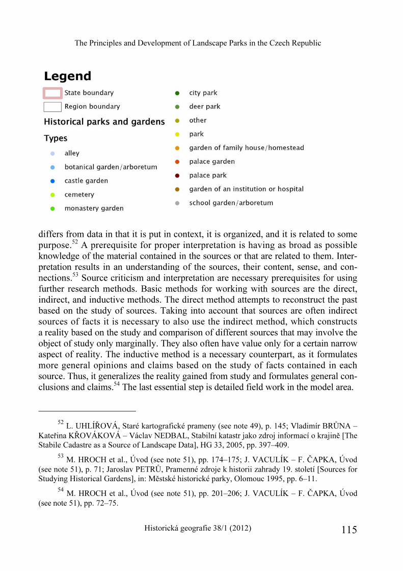
The Principles and Development of Landscape Parks in the Czech Republic
Historická geografie 38/1 (2012) 115
differs from data in that it is put in context, it is organized, and it is related to some purpose.52 A prerequisite for proper interpretation is having as broad as possible knowledge of the material contained in the sources or that are related to them. Inter-pretation results in an understanding of the sources, their content, sense, and con-nections.53 Source criticism and interpretation are necessary prerequisites for using further research methods. Basic methods for working with sources are the direct, indirect, and inductive methods. The direct method attempts to reconstruct the past based on the study of sources. Taking into account that sources are often indirect sources of facts it is necessary to also use the indirect method, which constructs a reality based on the study and comparison of different sources that may involve the object of study only marginally. They also often have value only for a certain narrow aspect of reality. The inductive method is a necessary counterpart, as it formulates more general opinions and claims based on the study of facts contained in each source. Thus, it generalizes the reality gained from study and formulates general con-clusions and claims.54 The last essential step is detailed field work in the model area.
52 L. UHLÍŘOVÁ, Staré kartografické prameny (see note 49), p. 145; Vladimír BRŮNA –
Kateřina KŘOVÁKOVÁ – Václav NEDBAL, Stabilní katastr jako zdroj informací o krajině [The Stabile Cadastre as a Source of Landscape Data], HG 33, 2005, pp. 397–409.
53 M. HROCH et al., Úvod (see note 51), pp. 174–175; J. VACULÍK – F. ČAPKA, Úvod (see note 51), p. 71; Jaroslav PETRŮ, Pramenné zdroje k historii zahrady 19. století [Sources for Studying Historical Gardens], in: Městské historické parky, Olomouc 1995, pp. 6–11.
54 M. HROCH et al., Úvod (see note 51), pp. 201–206; J. VACULÍK – F. ČAPKA, Úvod (see note 51), pp. 72–75.
Markéta Šantrůčková
Historická geografie 38/1 (2012) 116
Selected landscape parks in the Czech Republic
Today in the Czech Republic there are several hundred landscape parks of which several have significance on the European level. Park designers knew the work of their predecessors and contemporaries, with whom they were often in personal con-tact, and thus we can observe mutual inspiration between them, as well as inspiration from German, French, and English parks that were gleaned from travels throughout Europe. One of the first in the Czech lands was the park of Josef Vojtěch z Hodic in Slezské Rudoltice, which was established as early as the 1760s, but which after the death of its founder, quickly disappeared. The first preserved landscape parks date back to the 1770s and 1780s. The Romantic parks in Vlašim (belonging to the Auerspergs), in Červený Hrádek (belonging to the Rottenhams), in Krásný Dvůr (be-longing to the Černíns), and in Nové Hrady (belonging to the Buquoys) are among the most important from this period, and the concept of the picturesque was in-corporated into their design. The designers of these parks made ingenious use of the topography, which included stream valley slopes, protuberances, and gorges. Follies were added to parks, which enhanced the effects of their parts.
In contrast the following parks were based more on Classicist principles of the clear division of spaces using axes: the Jemčina game preserve (belonging to the Černíns), the expansive Lednicko-Valtický area (belonging to the Lichtensteins), and Kačina (belonging to the Choteks). These modifications were made at the turn of the 19th century most frequently in flat lowland and basin areas, where spaces could be designed with the help of expansive grassland, water, and forest areas. A beauti-fully preserved example of a ferme ornée is the park in Veltrusy (belonging to the Choteks), which is also on the flat land of the Vltava River basin and is marked by a clear central axis. Fields were included in the composition of this ferme ornée, referring to idealized notions of the bucolic lives of villagers. Changes were made in the actual land of these parks in lowland areas, as ponds and canals were deepened, water-logged areas were drained, and artificial hills were created. An early example of the significant use of exotic tree species is in Chudenice (belonging to the Čer-níns); a fully developed park of this type is that of Arnošt Emanuel Silva-Tarouca in Průhonice from the 1890s. These parks are artfully designed arboretums and have value as collections, as they are focused on including as many exotic or interesting tree species as possible.55
55 B. KAVKA et al., Krajinářské sadovnictví (see note 8), pp. 259–264; Zdeněk DOKOUPIL
– Pavel NAUMAN – Dušan RIEDL – Ivan VESELÝ, Historické zahrady v Čechách a na Moravě [Historical Gardens in Bohemia and Moravia], Praha 1957; J. HENDRYCH, Tvorba (see note 34), pp. 156–163; J. HORKÝ, Vývoj (see note 15), pp. 176–183.
The Principles and Development of Landscape Parks in the Czech Republic
Historická geografie 38/1 (2012) 117
Conclusion
The study of landscape parks and their landscape and topographical connections is not yet a common topic in historical geography. It is a fruitful topic and interesting conclusions can be made from it. The study of landscape modification and terrain changes is relatively difficult, as they require detailed study of literature, heuristic research of sources including subsequent criticism and interpretation, as well as de-tailed field research. The analysis of old maps using a GIS is an important part of this.
Landscape parks are specific areas, where the influences of natural conditions and intentional human intervention intersect closely. It is typical of such parks that they tried to fuse these human modifications with nature, and unknowing visitors often cannot even recognize this. This fact contributes to the pleasant impression given by landscape parks, but it also carries the risk of underestimating intentional terrain changes and the relationship of parks with their surroundings. In relation to this in the field of park protection there is greater emphasis on the protection of composition, of dendrologically valuable tree species specimens, and/or valuable botanical or zoological areas. The topography and configuration of the terrain are not usually mentioned in relation to features to be protected. At the same time the insensitive transformation of landscape parks for example into golf courses (as happened for example in the extremely valuable Kynžvart and Hrádek u Nechanic parks) can significantly degrade landscaping despite the fact that composition and valuable organisms have been preserved. In the same way changes in the delicate tissue of relationships between parks and their surroundings can clearly reflect society-wide transformations.
Markéta Šantrůčková Principy tvorby a vývoj krajinářských parků v České republice a jejich studium z hlediska historické geografie
Příspěvek představuje krajinářské parky jako objekty výzkumu historické geografie, jejíž významnou výhodou je syntetický přístup k jejich studiu oproti oborovému přístupu jiných věd, jejichž objektem studia také parky jsou (dendrologie, zahradní architektura, dějiny umění, biologie). Věnuje se principům tvorby a budování parků, jejich vazbám na přírodní i kulturně-společenské prostředí. Interpretuje společenské podněty a inspirační výcho-diska, které vedly k rozšíření módy krajinářských parků, a zásady při tvorbě těchto parků, které určují jejich vzhled. Krajinářský sloh se vyvinul na Britských ostrovech v 18. století (Shaftesbury, Addison, Pope) a od jeho druhé poloviny se začal šířit do kontinentální Evropy. Důležitá pro další vývoj byla jeho percepce ve Francii (Rousseau) a v německých zemích (Kant, Hirschfeld), které obohatily evropské krajinářské parky svébytnými prvky.
Markéta Šantrůčková
Historická geografie 38/1 (2012) 118
V souvislosti s ranými krajinářskými parky byly diskutovány zejména tři estetické kategorie – krása, vznešenost a především malebnost. Díky poměrně úzké spojitosti kra-jinářství a malířství byl pojem malebnosti přenesen i na vnímání krajiny a zahrady. Dva životní postoje se výrazně projevovaly v zahradním umění přelomu 18. a 19. století – kla-sicismus a romantismus. Zásadní skutečností pro tvorbu krajinářských parků a jejich vní-mání současníky bylo, že park byl pojímán jako vrcholné a souborné umělecké dílo. Krajinářský park v sobě spojoval kategorie prostoru, hmoty i času a integroval do sebe další umělecké disciplíny. Vyplývalo to z obdivu k přírodě, který vedl až k jejímu zbož-štění. Krajinářské parky začaly být nově chápány jako idealizované výseky domácí krajiny, zároveň ale byly složitě umělecky ztvárněny. Obliba volného krajinářského slohu se v Evropě udržela s obměnami danými jeho dlouhou existencí po celé 19. století.
Další diskutovanou otázkou je problém obnovy a s ním související současné funkce a využívání krajinářských parků v moderní společnosti. Příspěvek nastiňuje i metody studia krajinářských parků, které v sobě propojují historický (studium a interpretace pramenů) a geografický přístup (GIS analýza mapových podkladů, terénní průzkum a měření).
HISTORICKÁ GEOGRAFIE 38/1 (2012)
http://www.hiu.cas.cz/cs/mapova-sbirka/historicka-geografie.ep/
119
Aleš Vyskočil*
THE TALE OF THE LANDSCAPE IN THE CZECH LANDS IN THE 19TH CENTURY
Keywords
Abstract
19th century landscape transformation Czech lands industrialization urbanization railroad environment nature
The study describes the transformation of the Czech lands in the course of the 19th century. In an over-view, it introduces the process of transformation of a landscape shaped primarily by the baroque period into an industrial landscape. It notes individual processes, which significantly impacted landscape structures (such as industrialization, urbanization, development of transportation infrastructure etc.). It points to the transformation of the way in which land was used. It also notes the different kinds of environmental impact and the loss of landscape identity as well as reactions to these negative phenomena (nature preservation, tourism, public green areas).
* Mgr. Aleš Vyskočil, Ph.D., The Institute of History, Academy of Sciences of the Czech
Republic, v. v. i., Veveří 97, Brno, CZ – 602 00. E-mail: [email protected]. – This article is a result of the research project “Historical Geography Research Centre”, supported by The Grant Agency of the Czech Republic (No. 410/12/G113).
Aleš Vyskočil
Historická geografie 38/1 (2012) 120
Introduction
In the course of the so-called “long” 19th century,1 the Czech lands underwent a number of important changes, which resulted in a definitive transformation of the essentially traditional, late feudal society to a modern capitalistic society. This transi-tion was connected to a variety of complex changes in all areas of the civic life. We encounter the results of some of these changes to this day, as many of the trends and processes that had been started continue to the present day. What was created at this time was the fundamentals of the contemporary modern society and of its structures practically in all spheres – in the political, economic, social, cultural, spiritual and other areas, not only in the Czech lands, but in all developed countries in Europe.
Landscape was one of the spheres that were transformed in an unprecedented way in the course of the 19th century. It is at this time that the otherwise gradual process of landscape creation, with landscape as the complex and changing system that it is, becomes much more dynamic. Man becomes the deciding factor in the mutual interaction of natural and anthropogenic processes. Human activities thus transform the cultural landscape that had been up until that point relatively stable; human activities become the determining and in many ways dominant aspects of landscape creation. All in all, landscape is influenced by man like never before. Deep political, economic and social changes of the 19th century were reflected in the structure of landscape, its usage, in the structure of settlement etc. in an unusually significant ways. The original proto-industrial ventures, changes in the system of agriculture, in settlement structures and in the fundamentals of transport networks portended big, previously unimaginable changes. But it was especially the second half of the 19th century that indelibly affected the shape and geographic plasticity of the natural landscape. The process of industrialization, which had at this time been fully underway, not only influenced the most proximate neighborhoods of industrial ventures and factories, but was also connected to other phenomena such as urbaniza-tion, merging of settlements and re-structuralization of entire settlement networks, mass migrations of the population, development of transport infrastructure (intro-duction of rail transport and regulation of waterways), also innovations in agriculture, amelioration, directed renewal of forests, consolidation of land plots etc. Massive intro-ductions of anthropic elements into landscape and significant changes in the secondary micro- and macro-structure of landscape (that is landscape changed and exploited
1 In the European context, the “long 19th century” is seen to have started with the start of the
French Revolution and ended with the declaration of WWI (1789–1914). In the Czech context, the “long 19th century” is seen to have started with the reign of Joseph II (1780–1914).
The Tale of the Landscape in the Czech Lands in the 19th Century
Historická geografie 38/1 (2012) 121
by man) were especially typical for this period and occured in an extent that had previously been unimaginable.
All of the above-mentioned processes and phenomena influenced landscape in a formative way for long decades. As a result, the look of the landscape changed in a fundamental and irreversible way. There processes and phenomena imparted the appearance and elasticity, which lasted well into the 20th century and often even to this day. The 19th century thus found itself among centuries characterized by landscape revolutions, alongside neolithic agriculturalists, medieval colonization and baroque order and harmony. The cultural impact of the “long century” is and will be overlaid by subsequent milestones, in the same way that medieval colonization overlaid the cultural advance of the neolithic period and the baroque period modified high medieval cultural landscape. The legacy of this century is naturally much more legible on the face of the landscape than is the case for older landscape structures.2
The 18th century – baroque landscape and harbinger of momentous changes
In the Czech lands, the combination of elements of high medieval landscape (basic urban framework – settlement network and differentiated town and village space, three-field system of agriculture, deforestation, road network) enriched with early modern modifications, such as fishing and cereal production, and covered by baroque combined landscape (organized cultural landscape, transition from continual land-scape to mosaic landscape, ubiquitous elements of sacred and secular architecture) lasted well into the 19th century. This multilayered landscape structure was full of evidence of agricultural expansion and of forest exploitation. Landscape was inter-woven with networks of bigger and smaller settlements – towns and village areas and networks of agricultural areas. The central settlement by a river with adjacent gardens and orchards, with connected system of fields, followed by pastures, meadows
2 On the landscape and its transformation, see: Jiří LÖW – Igor MÍCHAL, Krajinný ráz [The
character of a landscape], Kostelec nad Černými lesy 2003; Eva SEMOTANOVÁ, Historická geo-grafie českých zemí [Historical geography of the Czech lands], Praha 22006; Eva SEMOTANOVÁ et al., Ottův historický atlas [Otto’s historical atlas], Praha 2007; Krajina v České republice [Land-scape in the Czech Republic], edd. Jan Němec – František Pojer, Praha 2007; Jiří SÁDLO – Petr POKORNÝ – Pavel HÁJEK – Dagmar DRESLEROVÁ – Václav CÍLEK, Krajina a revoluce. Významné přelomy ve vývoji kulturní krajiny českých zemí [The landscape and revolution. Im-portant turning points in the development of cultural landscape in the Czech lands], Praha 32008; Václav MATOUŠEK, Čechy krásné, Čechy mé. Proměna krajiny Čech v době industriální [My Bohemia, Bohemia the beautiful. Landscape transformations in Bohemia during the industrial period], Praha 2010; Historický atlas měst České republiky [Historical atlas of the towns of the Czech Republic], vol. 1–23, Praha 1995–2011 (www.hiu.cas.cz/cs/mapova-sbirka/historicky-atlas-mest-cr.ep/).
Aleš Vyskočil
Historická geografie 38/1 (2012) 122
and ending in forests is exemplary of this model. The percentage share of forests in this arrangement changes depending on the altitude and with that on the quality of accessible agricultural soil. This world was relatively stable, and for a long time sufficient to the needs of the society, which was not very mobile. The majority of the population lived in the country and was devoted to self-sufficient production of food-stuffs. Time-proven forms of agriculture, tilling of the soil and small-scale exploita-tion of natural resources (wood, water) froze the shape of Czech landscape for a long time. The character of the Czech landscape was determined especially by traditional, unchanging manner of soil exploitation – the three-field system of agriculture. From the turn of the 16th century, the noble manor started to assert itself as a specific autono-mous element. It continued to change the local character of the landscape, depending on the economic activities of the owners. The structure of the basic administrative and economic units (estate) was fundamentally changed in the baroque period, following the battle of the White Mountain, when the wave of confiscations created giant estates for the more successful nobility. With them came a new focus on the glass and metallurgical production. From the 17th century on, one can see a continuity in the effort to modify the course and network of rivers to suit industrial needs (local modification of rivers and the construction of the first navigable canals, intended for transport of wood from the mountain areas).
Even prior to the introduction of the revolutionary processes at the end of the 18th and in the 19th century, Czech landscape received its characteristic appearance in the course of the second half of the 17th and first half of the 18th century, occasionally in the second half of the 18th century. The baroque period gave Czech landscape new lineal elements (boundaries, avenues of trees, mill races, networks of paths and roads), meadows, pastures and small fields, towns with fortifications (Praha, Cheb, Brno, Olomouc, Hradec Králové but also Terezín and Josefov), castle precincts with gardens and parks, solitary commercial buildings and residential-eco-nomic aggregates, a number of sacred buildings from wayside shrines and village churches to monasteries and grandiose pilgrimage churches at hillsides as well as unique examples of combined landscape aggregates (Kuks and Lysá nad Laben, Jičín region). Towns and villages were taken over by baroque buildings demonstrating the victory of Catholicism and of the Habsburg counter-reformation and declaring the introduction of a new nobility after the battle of the White Mountain. With their small sacral elements, these buildings dominated also their surroundings. The baroque period was characterized by a wide-scale impact on the landscape (more so than any other period) and transformed the Czech landscape into a compact unit. By the end of the baroque period we can describe this realm as being charcaterized by a highly cultural, fully colonized landscape, with only a few remaining highland
The Tale of the Landscape in the Czech Lands in the 19th Century
Historická geografie 38/1 (2012) 123
areas, which retained their traditional character. After that, what is changing is the intensity of colonization (transformation of landscape).3
In the course of the 18th century, the supplies of wood noticeably decreased owing to the growing proto-industrial (manufacturing) production, especially glass and metallurgical as well as to increased construction activities. This shortage forced foresters to interfere significantly in the composition of forests. Given their interest in exploitation of available forests (for fuel and other uses), they turned to cultiva-tion of fast-growing kinds of wood, both coniferous and deciduous trees, namely pine, spruce, larch, poplars, maples, ashes, with the result that they gradually displaced firs, beeches, and oaks. In many areas, forests gained a new appearance and their borders were transformed as was the size of forested areas, which starting in the first half of the 19th century began again to increase. The 19th century was thus characterized by forests defined by spruce mono-culture that was quite different from the kind of forest that had originally been there.4
3 On the baroque landscape, see Jaroslava STAŇKOVÁ, Barokní krajinná tvorba [Baroque
landscape development], in: Zelené systémy a jejich význam v krajinném obraze [Green systems and their importance in the landscape framework], ed. Michal Hexner, Praha 1986, pp. 24–27; Václav VALTR, Krajinářské úpravy v 17. a 18. Století [Landscape alterations in the 17th and 18th
centuries], in: ibidem, pp. 34–42; Jan ROYT, Posvátná krajina Čech [The sacred landscap of Bohemia], in: Tvář naší země – krajina domova. Umělecká reflexe krajiny [Face of our land – landscape of home. Artistic reflections of landscape], edd. Kateřina Dejmalová – Jiří T. Kotalík, Lomnice nad Popelkou 2001, pp. 41–45; Jan HENDRYCH, Barokní zahrady a krajinné úpravy v Čechách [Baroque gardens and landscape development], in: ibidem, pp. 12–20; Pavel HÁJEK, Česká krajina a baroko. Urbanismus českého baroka na příkladu města Jičína a jeho okolí [Czech landscape and the baroque. Urbanity of the Czech baroque on the example of Jičín town], Praha 2003; Jiří SÁDLO – Pavel HÁJEK, Česká barokní krajina: co to vlastně je? [Czech baroque landscape: what is it actually?], Dějiny a současnost 26, 2004, vol. 3, pp. 29–33, vol. 4, pp. 45–49; Jiří KUPKA, Barokní poutní krajina [Baroque pilgrimage landscape], Zahrada – park – krajina 17, 2007, vol. 3–4, pp. 33–36; Eva SEMOTANOVÁ, Kladsko jako barokní komponovaná krajina [The county of Kladsko as a baroque designed landscape], HG 35, 2009, pp. 161–198; Jiří KUPKA, Krajiny kulturní a historické [Historical and cultural landscapes], Praha 2010; Lenka KULIŠŤÁ-KOVÁ, Pozdně renesanční a raně barokní komponovaná krajina Mikulovsko-Falkensteinsko [Late renaissance and early baroque designed landscape in the region Mikulovsko-Falkensteinsko], in: Komponovaná kulturní krajina a možnosti její obnovy a zachování [Designed cultural landscape and the possibilities of its renewal and its preservation], ed. Petr Kubeša, Olomouc 2010, pp. 45–55; Pozemkové úpravy v České republice [Land development in the Czech Republic], edd. Jan Váchal – Jan Němec – Jiří Hladík, Praha 2011.
4 On the development of forests, see Josef NOŽIČKA, Přehled vývoje našich lesů [Over-view of the development of our forests], Praha 1957; Leoš JELEČEK, Vývoj lesnatosti Čech ve 2. polovině 19. století [The development of forestation in the second half of the 19th century], HG 10, 1973, pp. 177–205; Zdeněk POLENO, Příměstské lesy [Suburban forests], Praha 1985; Hilde-
Aleš Vyskočil
Historická geografie 38/1 (2012) 124
The period since the second half of the 18th century was characterized by an intense desire for greater yields in agriculture, one in which the share of the land devoted to three-field system would be limited or entirely eliminated. More progres-sive large estates were among the first to eliminate the unprofitable three-field system; among them were especially the Schwarzenberg estates in southern Bohemia. Animal husbandry played an important role in the transformation of the systems of farming as it required high-quality fodder for stabled animals. Fallow fields thus started to be used for the production of fodder and potatoes, which, among others enriched the menu of poorer classes and solved the problem of self-sufficiency in less fertile agricultural areas. The final assertion of potatoes on a large-scale was related to famines in the 1870s, as a result of which potatoes were promoted to one of the basic foodstuffs. Increased demand for agricultural products especially owing to high demographic growth, economic revival and growing need to supply armies caused a number of new trends; among them, the trend of cultivation of fallow lands and transition to higher, mixed form of agriculture. The demand for textile crops, such as flax and hemp, which became pronounced especially after the territorial loss of Silesia (a leading textile-producing area). These innovations in agriculture ended the period in Czech landscape that was characterized by monotonous cereal fields: crop variety has also a visual dimension. The increased demand for arable land also led to the draining of lakes and eradication of pastures. The character of dominant village landscape continued to change.5
Increased building activity and the diffusion of settlements (after the de-popula-tion and agrarian depression of the 17th century) also testifies to the demographic and economic growth in this period. Important secular and sacred buildings appeared in this period, settlements began to differentiate (residential, defensive-fortifications, spa etc), towns were leaving their medieval urban structures behind (internal reconstruc-tions inside the fortifications imparted a specific baroque look practically to all towns); the settlement pattern in villages gradually changed as well. Cottagers settled expansive village greens and condensed development near peasant farms – this phenomenon was also typical for the duration of the 19th century.6 Wooden structures came to
garda VALEŠOVÁ, Lesy na území Prahy, jejich historie a současnost [Forests in Prague’s urban area, their history and the present], Staletá Praha 15, 1985, pp. 251–260.
5 On the development of agriculture, see Antonín KUBAČÁK, Dějiny zemědělství v čes-kých zemích. 1. díl (od 10. století do roku 1900) [A history of agriculture in the Czech lands, vol. 1 (from the 10th century until 1900)], Praha 1994; Magdalena BERANOVÁ – Antonín KUBAČÁK, Dějiny zemědělství v Čechách a na Moravě [A history of agriculture in Bohemia and Moravia], Praha 2010.
6 Josef PETRÁŇ et al., Dějiny hmotné kultury 2/1 [A history of material culture 2/1], Praha 1995, p. 403.
The Tale of the Landscape in the Czech Lands in the 19th Century
Historická geografie 38/1 (2012) 125
be replaced by stone buildings, which were much safer. Settlement structure under-went changes as well, with a new hierarchy of settlements emerging, one that reflected the new administrative and political realities (municipal and regional centers, royal towns as future district centers and local centers of estates in part as future seats of judicial authorities of local administration). In addition, noble and burgher enterprises (such as sawmills, mills, breweries, iron mills, glassworks, print-works and others) sprung up at the outskirts of towns and in village countryside (depending on natural resources and road accessibility). Those eventually became the first specialized manu-facturing enterprises. The presence of manufacture often provided new impulses for further population growth, and sometimes manufacturing enterprises led to urban development, such as the construction of workers’ quarters (worker colonies).
The state began to influence the shape of the landscape by its orders and other kinds of interference. It issued forest directives, which regulated forest economies and which were supposed to prevent the depredation of forests, and introduced artificial reclamation. In some places, the land was newly divided, especially on some large estates, previously monastic but now owned by the state; the land was subdivided, and in some places where arable land was freed up, new villages were founded. As a result of a land reform (“Raabschen system” in German), two hundred and forty five small villages with the typical regular street ground plan were added to the contemporary settlement network (of them, 128 in Bohemia and 117 in Moravia).7 Economic growth demanded transport arteries that would allow the transport of merchandise. Those, however, were greatly lacking. In fact, the poor state of roads and their scarcity crippled economic growth as the traditional road network ceased to be satisfactory. In the second half of the 18th century, Czech landscape thus saw the construction of the first kilometers of artificial surface roads of a more modern kind; the state was naturally very interested in their construction for military-strategic and economic reasons. It was at this time that a basic road network with stone base, which extended more or less in one, straight direction, came into being. By the end of the century, the so-called imperial roads were built, about 500 km in Bohemia and about 600 km in Moravia (in the following period the ratio would change in favor of Bohemia). Coach and postal transport grew more robust, but it did not save the state’s economy, and influenced the landscape only minimally. This was to change with the phenomenon called railroads.8
7 J. LÖW – I. MÍCHAL, Krajinný ráz (see note 2), p. 385. 8 For more information about the construction of road networks, see: František ROUBÍK,
Silnice v Čechách [Roads in Bohemia], Praha 1938; Josef HONS, Dejiny dopravy na území ČSSR [A history of transportation in Czechoslovakia], Bratislava 1975; Jiří F. MUSIL, Po stez-kách k dálnicím. Kapitoly z dějin silnic, silničních dopravních prostředků a silničního stavitelství [From footpaths to highways. Chapters from the history of roads, road vehicles and road con-
Aleš Vyskočil
Historická geografie 38/1 (2012) 126
19th century – the era of an intensive impact on landscape
The 19th century impacted the shape and character of landscape and changed the nature of its usage in a fundamental way, one which undermined the existing, funda-mentally sustainable, landscape use. Renewable sources of energy were replaced by fossil fuels, which forever changed the world. The impact on the landscape was enormous and did not have an equal in the history as for its intensity. The relationship between man and his landscape changes too, gaining a new dimension. Technical revolution allowed people almost unlimited construction possibilities regardless of natural conditions. Whereas earlier man’s activities in the landscape were connected to preceding cultural layers, the industrial period completely changed the nature of the landscape, covering, dislocating or entirely obliterating existing relationship between man and the landscape and disrupting the continuing tradition.9 All the
struction], Praha 1987; Milan HLAVAČKA Cestování v éře dostavníku. Všední den na středo-evropských cestách [Travelling in the era of the stage-coach], Praha 1996.
9 J. LÖW – I. MÍCHAL, Krajinný ráz (see note 1), p. 411.
The Tale of the Landscape in the Czech Lands in the 19th Century
Historická geografie 38/1 (2012) 127
processes of transformation that had set in motion the tradition feudal society were reflected in the face of the Czech landscape whether directly or indirectly. The land-scape is thus to this day a reflection of that tumultuous period. Whereas the first half of the century was characterized by isolated focal points of noble enterprises (both industrial and agricultural) and remained, therefore, under the influence of local and regional landscape-forming factors, the second half would transform the landscape in a complex and fundamental way. This was especially the result of the develop-ment of railroads, which allowed unlimited movement of people and merchandise. The reforms and laws from the first half of the 19th century were undoubtedly one of the pre-requisites to any such transformation. Any barriers to a free movement of people fell when the patrimonial administration and serfdom were both abolished. The law that abolished serfdom, that is the previously unbreakable bond with the land, thus began to free the workforce. This law allowed the ranks of specialized professions, needed for the development of industry, to grow, but it continued to keep the population within the prescribed area of the estate, especially in the manor or its surroundings.
The Napoleonic wars and the continental blockade were the main impulse for the development of entrepreneurship; they allowed significant increase especially in the production of textiles. From 1820s, the Czech lands were hit by the first wave of industrialization. Technical and technological innovations were being introduced into production, the construction of basic road network culminated, the first instances of economic migration to towns were discernable, worker colonies began to appear. All these were important markers suggesting that the Czech lands find themselves in the first phase of the industrial revolution.10 The invention of the steam engine, which required coal for its operation, led to large-scale production. Coal that was made into coke allowed the development of metallurgy and proved to be a turning point in the use of tools, equipment and machines. Noble dominions continued to be the main instigators of industrialization, towns and burghers joined them in the 1860s on. Aristocratic entrepreneurs often added mining activities (to support their
10 On the industrial revolution, see: Jaroslav PURŠ, Průmyslová revoluce v českých zemích
[The industrial revolution in the Czech lands], Praha 1960; Pavla HORSKÁ-VRBOVÁ, Český průmysl a tzv. druhá průmyslová revoluce [The Czech industry and the so-called second industrial revolution], Praha 1965; Václav PRŮCHA, Hospodářské dějiny Československa v 19. a 20. století [Economic history of Czechoslovakia in the 19th and 20th centuries], Praha 1974; Studie o technice v českých zemích 1800–1918 [Studies about technology in the Czech lands between 1800 and 1918], vol. 1–4, Praha 1983–1986; Ákoš PAULINYI, Průmyslová revoluce. O původu moderní techniky [Industrial revolution. On the origin of modern technology], Praha 2002; Ivan JAKUBEC – Zdeněk JINDRA, Dějiny hospodářství českých zemí od počátku industrializace do konce habs-burské monarchie [An economic history of the Czech lands from the rise of industrialization to the end of the Habsburg monarchy], Praha 2006.
Aleš Vyskočil
Historická geografie 38/1 (2012) 128
metallurgic, glass and textile factories) to the agricultural production on their estates; as a result, vassal towns began to emerge. The production of textiles (which was key economic activity) moved from valleys of mountainous areas to the interior, mostly larger towns thanks to the proliferation of the steam engine. Czech lands began to differentiate, specific economic conditions gave rise to specific regions and created the rudiments of future industrial zones. The rise of industrialization, which had been gradual up until this point, would be fundamentally influenced by the extensive rail network, constructed by the state and private sector respectively. A dense network of railroads would become the backbone of transport infrastructure. As early as in 1870s, the rail system in the Czech land was measured at 4623 kilometers (3455 km in Bohemia, 1168 in Moravia and Silesia).11 These were divided among important long-distance routes and shorter junctions that reflected regional needs (typically, they connected mining districts with domestic or international industrial centers). This basic network was significantly enriched by World War I, at which time local railroads were added, which meant that basically every Czech and Moravian town could be reached by rail.12
It is only a slight simplification to say that the shape of today’s landscape was determined primarily by railroad. In itself, the railroad’s direct impact on land-scape was only slightly larger than that of the road network. Rail systems were more complex than road systems, because they required a number of auxiliary structures (train stations, depots, bridges, tunnels, viaducts and so on); to those, one can also add the straightening of rivers, along which rails would often be traced out, de-forestation or interference with local construction, which were changes mostly of the local character. Like the road network, it was similarly arranged in the manner
11 Milan HLAVAČKA, Dějiny dopravy v českých zemích v období průmyslové revoluce
[A history of transportation in the Czech lands at the time of the industrial revolution], Praha 1990, p. 102.
12 On the development of the railroads, see Theodor ŽÁKAVEC, Lanna. Příspěvek k hos-podářským dějinám v Čechách a v Československu [Lanna. A contribution to the history of the economic development in Bohemia and in Czechoslovakia], Praha 1936; Josef HONS, Dejiny dopravy na území ČSSR [A history of transportation in Czechoslovakia], Bratislava 1975; Milan HLAVAČKA, Dějiny dopravy v českých zemích v období průmyslové revoluce [A history of transportation in the Czech lands at the time of the industrial revolution], Praha 1990; Josef HONS, Čtení o Severní dráze Ferdinandově [Reading about the Emperor Ferdinand’s Northern railway], Praha 1990; Stanislav PAVLÍČEK, Naše lokálky. Místní dráhy v Čechách, na Moravě a ve Slezsku [Our local trains. Local railroads in Bohemia, Moravia and Silesia], Praha 2002; Pavel SCHREIER, Zrození železnic v Čechách, na Moravě a ve Slezsku [The rise of the railroad in Bohemia, Moravia and Silesia], Praha 2004; Mojmír KREJČIŘÍK, Kleinové. Historie moravské podnikatelské rodiny [The Klein family. A history of a Moravian family of entrepreneurs], Brno 2009.
The Tale of the Landscape in the Czech Lands in the 19th Century
Historická geografie 38/1 (2012) 129
of spokes, radiating from the center out into the countryside. Vienna was the primary center, in the Czech lands it was Prague and, to a lesser extent, Brno; (in Bohemia, the road network resembled a spokes that met in Prague, its natural center, the Moravian network was more diffuse). The impact of the rail system was fundamental as it enabled large-scale social transformation, allowing the movement of cargo and of people to an extent that was previously unimaginable. It also connected natural re-sources with economic centers and transformed the settlement hierarchy, when tradi-tional centers that were lacking rail connections were surpassed by formerly secondary centers, which had been connected to the rail network (for example Choceň at the expense of Litomyšl and Vysoké Mýto, Pardubice at the extense of Chrudim and Hra-dec Králové, and Kouřim, which was primarily a town of craftsmen also experienced a decline). It also enabled a tumultuous development of coal mining, which it not only needed for its own operation but which it was able to transport in vast quantities, previously also unimaginable, over long distances. The process of industrialization was accelerated by railroad construction, new industrial facilities came into being, for mining, engineering, metallurgic, power production (regions of Kladno, Ostrava, Plzeň, Most and Teplice and others); new centers sprung up around road and rail crossings. The introduction of the rail-system unglued the existing static structure of settlement. From settlement networks around traditional patrimonies, a new dynamic pattern of settlement came into being; it followed transportation axes, whether rail or ancillary road.
When the barriers on travel to work fell (as a result of the abolition of serf-dom), the entire society boarded the train. Industrial development in the conditions of an unusually liberal economic policy, combined with the new possibilities of trans-portation, caused a chain reaction in the shape of an extensive migration of the population in pursuit of new work opportunities. All of this turned the existing demo-graphic models on their heads, jump-starting the process of urbanization.13 Intensifying
13 On the urbanization and demographic processes, see Ludmila KÁRNÍKOVÁ, Vývoj oby-
vatelstva v českých zemích 1754–1914 [The development of the population in the Czech lands, 1754–1914], Praha 1965; Jaroslav LÁNÍK, The development of Czech towns in the 1830’s to 1850’s, HD 15, 1986, pp. 377–410; IDEM, Otázky vývoje urbanizace v Čechách v druhé polovině 19. století [Questions of urban development in Bohemia in the second half of the 19th century], HD 16, 1989, pp. 145–181; Historický atlas měst České republiky [Historical atlas of the towns in the Czech Republic], vol. 1–23, Praha 1995–2011 (www.hiu.cas.cz/cs/mapova-sbirka/historicky-atlas-mest-cr.ep/); Karel KUČA, Města a městečka v Čechách, na Moravě a v Slezsku [Towns and small towns in Bohemia, Moravia and Silesia], vol. 1–8, Praha 1996–2011; Pavla HORSKÁ – Eduard MAUR – Jiří MUSIL, Zrod velkoměsta. Urbanizace českých zemí a Evropa [The rise of the metropolitan area. Urbanization in the Czech lands and Europe], Praha – Litomyšl 2002; Město a městská společnost v procesu modernizace 1740–1918 [The town and the urban society in the process of modernization], edd. Pavel Kladiwa – Aleš Zářický, Ostrava 2009.
Aleš Vyskočil
Historická geografie 38/1 (2012) 130
production required a constant presence of large numbers of workers, which could not commute to the factories on a permanent basis and had, therefore, to move nearer. Spacial expansion of urban development, caused by population growth, had the greatest impact in the genesis of urban industrial settlements, organic connections between isolated settlements, developing suburban areas and the like. A new type of landscape emerged: so-called urbanized landscape (Prague and surrounding areas, regions of Brno, Ostrava, Liberec). The drain of village populations in favor of towns also impacted traditional structure of landscape, and population migrations influenced the nature and intensity of landscape use. The urban sector continued to strengthen, its economic power and life-style soon began to determine the character of the countryside. New types of economic zones came into being: new industrializes areas were added to the traditional manufacturing areas. The new industrial areas were marked by incremental population growth and density of population. Also, new regions of intensive development of modern agricultural production with related food processing industries were added to stable and more or less stagnating agri-cultural areas. With regards to the landscape structure, the Czech realm can be de-scribed as a combination of urban-industrial, agrarian and natural zones.
In the newly industrialized areas, the direct impact on landscape was naturally most significant. This transformation can be best documented on examples of village areas, hit by waves of industrialization, where village landscape came to have an industrial and urban character. There were also clearly observable shifts not only in categories of landscape usage, but also in the number, composition and economic activity of its population, in the spread and distribution of anthropic elements and phenomena in the landscape and in the changes of its structure. Kladno is a typical example; it is a town that was until the mid-nineteenth century an unimportant vassal town in a sparsely populated agricultural countryside. The township was the seat of the manor, but as late as early 19th century it boasted only a little bit over 600 in-habitants. The discovery of rich deposits of coal in the vicinity of Kladno changed the town’s trajectory forever. The first shafts were dug in the 1840s. The region was shown to be rich also in iron ore, and the area became the center for mining and metallurgical production. The rail system, the so-called Bustěhradský network, connected the sources of raw material with their markets. The economic boom attracted thousands of paupers, whose little houses on the periphery documented the spontaneous growth of the town. Whereas in 1843, the town numbered a little under 1,400 inhabitants, the first Austrian census of the 1869 reported over 10,000 inhabi-tants. Workers’ colonies were being constructed, the town expanded, the Kladno agglomeration was being born. The economic miracle continued further, before the war there were 1500 houses with almost 20,000 people. Thus, the city grew tenfold in the span of half century, and from originally a smallish settlement turned into the
The Tale of the Landscape in the Czech Lands in the 19th Century
Historická geografie 38/1 (2012) 131
most important industrial center in Bohemia.14 Blansko is an example of a landscape change that had a more regional character; it represented an early form of noble enterprise (in contrast with Kladno area, where nobility, state and burger entrepre-neurs all had their interests at stake). The metalworks at Blansko were promoted by the Salm family to a company that had no competitor either in Moravia nor in Silesia. The industrial zone, formed by iron mills, machine works and ancilary operations, grew up here during the first phase of industrialization. Industrial activity thus in fundamental way influenced the landscape as early as in the first half of the 19th
century. As in the case of Kladno region, the village character of the landscape was disturbed by mining and other activities resulting in defaced landscape, quarries, shafts, industrial towers and the like. The area was intersected by a rail artery, which also caused the meandering river in Blansko region to be straightened. The presence of the rail system did not only cause a qualitative change in the transport systems, but it also fundamentally impacted urbanization. It brought villages on both sides of the river closer together, and caused them to orient their future developments in each other’s direction. The economic boom in the Blansko region affected the character of the development, and workers’ colonies appeared in the vicinity of this town also, near the industrial plants. The population of Blansko doubled in the course of a half century, mostly owing to the newly arrived workers.15
Both of these examples provide sufficient evidence about a fundamental change in the landscape character related to the industrial revolution. The agricultural sector, which came to take on a service function for urban industrial sector, underwent a similar transformation. The agricultural revolution of the 19th century could be characterized, if we omit the change in feudal, socio-legal relationships in the direction of free enterprise, as a transition from traditional three-field system of land cultiva-tion to a mixed land cultivation, suppression of free pasture of animals and transition
14 Zdeněk KUCHYŇKA, Historie a současnost podnikání na Kladensku a Slánsku [History
and the present of entrepreneurship in Kladno and Slánsko region], Žehušice 2005; Historický atlas měst České republiky [Historical atlas of towns in the Czech Republic], vol. 17 – Kladno, ed. Robert Šimůnek, Praha 2007; Irena VEVERKOVÁ, Kladno, Praha – Litomyšl 2008.
15 Aleš VYSKOČIL – Pavel KLAPKA – Stanislav MARTINÁT, Proměny krajiny rurálního prostoru v zázemí průmyslového centra během 2. poloviny 19. století [Changes of the rural spaces in the landscape near an industrial center in the course of the second half of the 19th century], in: Historická krajina a mapové bohatství Česka. Prameny, evidence, zpřístupňování, využívání [His-torical landscape and the cartographic riches of the Czech lands. Sources, evidence, accessibility and usage], ed. Robert Šimůnek, Praha 2006, pp. 137–162; Aleš VYSKOČIL – Pavel KLAPKA – Eva NOVÁKOVÁ, Rekonstrukce proměny krajiny, sídel a sídelní struktury na příkladu Blanenska [A reconstruction of transformations of landscape, settlement and settlement structure, example of Blanensko region], HG 34, 2007, pp. 296–306.
Aleš Vyskočil
Historická geografie 38/1 (2012) 132
The Tale of the Landscape in the Czech Lands in the 19th Century
Historická geografie 38/1 (2012) 133
to stabling and related cultivation of fodder and introduction of new agricultural crops. The increase in cultivation of arable land slowed down, and in the mid-nineteenth century came to a complete halt. Pastures and meadows disappeared, in contrast, gardens and forests became more prominent. Fields with cereal were supplemented by potatoes, corn and sugar beets. Agriculture continued to intensify, and a new arable land continued to be obtained through the draining of lakes and re-cultivation of blind side river channels and waterlogged banks of big rivers in Bohemia (Labe, Ohře) and in Moravia (Morava, Dyje etc). Amelioration gained traction as a new agri-cultural method. New production areas (whose beginning can be traced back to the 16th century) were formed, grain production (Labe region, lower Ohře, ravines of lower Morava and Dyje-Svratka), hop production (Žatec region, Rakovník region, Louny region), viticulture (southern Moravia, vicinity of Prague and Mělník), also, after mid-nineteenth century, cereal, potato and sugarbeet (region of Hradec Krá-lové, Pardubice, Kolín, Prague, Mělník, Litoměřice, as well as central and southern Moravia) and fodder production (foothills of border mountain regions), or mixed types. From the second half of the 19th century on, the share of industry in agri-culture also grew, processing agricultural products, such as sugar industry, brewing and distilling industries. Sugar beets became the typical crop of the agricultural revolu-tion, when it was discovered for the production of sugar. Sugar making as a specific branch of industry thus soon became the most important branch of the food proces-sing industry. It fundamentally influenced not only the development of agriculture, but also the spread of coal mining, as their sizeable customer, and also influenced the layout of the rail network. Sugar beets impacted the landscape itself directly as a crop, but also by a network of narrow rails, connecting individual sugar-making opera-tions.16
With regards to land-use in the course of the 19th century, lower-yielding areas of the Czech landscape would typically introduce forests in place of the arable land, in the lower and more fertile areas, on the other hand, agricultural production became more intensified. For the majority of areas in the Czech lands, the preference was for making the fields more fertile, especially in the southern half of Bohemia, in central Českomoravská vrchovina and in lower areas, in Jeseníky and Beskydy mountains and the White Carpathians. Regional differentiation in the specific kind of production was typical. In comparison with the types of changes in landscape use, more than half of the area of the Czech lands were characterized by increase in forested and other areas (water, development) and a decrease in arable land. This type of development of macro-structure could be found across the realm; there was no discernable regional
16 On the development of agriculture and of the changes in soil exploitation, see note 5 and
also Leoš JELEČEK, Zemědělství a půdní fond v Čechách ve 2. polovině 19. století [Agriculture and land resources in Bohemia in the second half of the 19th century], Praha 1985.
Aleš Vyskočil
Historická geografie 38/1 (2012) 134
concentration of either. Its high frequency corresponded to the society’s transition from traditional forms of land-usage based on local and micro-regional conditions to a more hierarchical arrangement with a different development of urban and village areas. The increase in arable lands and decrease of forested lands – especially in lower areas of Moravia and along the Labe river– was yet another trend. The area of Českomoravská vrchovina and of southern Moravia, in contrast, saw increased forestation at the expense of arable and other types of land.17
17 Land use (Databáze LUCC Czechia, Přírodovědecká fakulta UK Praha; Ivan Bičík, Pavel
Chromý, Leoš Jeleček, Lucie Kupková). In electronic form, the database is accessible at www.lucc. ic.cz.
The Tale of the Landscape in the Czech Lands in the 19th Century
Historická geografie 38/1 (2012) 135
Man also tried to make a greater use of rivers, by building mountain navigable canals (for example Schwarzenberg and Vchyticko-tetovský canal in Šumava mountains). More radical regulation of rivers soon followed, including the so-called canalification of Czech rivers. Meandering rivers were straightened, often as a part of rail con-struction, which further remodeled the landscape. Systematic building of river damns was the culminating interference by water management (at the turn of the 20th century), required by increased demand for water, energy, but also as a protection from big floods. The largest number of such constructions was undertaken in north Bohemia, especially in Krušné Hory and in Liberec region.18 The process of making Czech rivers navigable continued. Before mid-nineteenth century, the upper segments of the
18 See Vojtěch BROŽA, Přehrady Čech, Moravy a Slezska [Dams in Bohemia, Moravia and
Silesia], Liberec 2005.
Aleš Vyskočil
Historická geografie 38/1 (2012) 136
following rivers were made navigable: Lužnice, Nežárka, Blanice, Malše and Otava, and work was being done on Vltava, Labe, Odra and Morava.19 Various projects to connect different rivers were eventually left unfinished, but various relicts of them remained in the landscape, in the form of water reservoir and canals.
Towns experienced tremendous growth, especially those on the main rail arteries
and their crossroads (Prague, Brno, Plzeň, Přerov, Liberec, Ostrava, Ústí nad Labem, Kladno). Industrial production was concentrated especially in these towns, though adjacent smaller settlements also participated. Most of these rapidly developing cities quickly lost their baroque character though in some places baroque town centers were preserved (such as in Olomouc, České Budějovice). However, towns that stagnated continued to be cloaked in a baroque guise. The disappearance of castle zones, which
19 Miroslav HUBERT, Paroplavba v Čechách [Steam navigation in Bohemia], Praha 1993; IDEM, Dějiny plavby v Čechách [A history of navigation in Bohemia], vol. 1–2, Děčín 1996–1997; Jan ČÁKA, Zmizelá Vltava [The vanished Vltava], Praha 32002; Miroslav HUBERT – Vlastimil PAŽOUREK, Počátky paroplavby na Labi [The rise of steam navigation on Labe river], Děčín 2002; František VICHTA, Historie pražské paroplavby [A history of steam navigation in Prague], České Budějovice 2008.
The Tale of the Landscape in the Czech Lands in the 19th Century
Historická geografie 38/1 (2012) 137
had previously served a military function but now became non-functional relics, are also typical for the 19th century. The pressure of the local government forced the state to give up these towns as fortresses and to permit the removal of defensive elements (castle walls as the characteristic element of towns was replaced by another – factory chimney). As a result, whole tracts of land between town centers and town peripheries opened up, which in turn allowed extensive development. In some cases, periphery came to be organically fused to the town center via this new development (for example in Prague), elsewhere the same open land was used to build a kind of beltway with parks (as in Brno). The construction was for the most part somewhat helter-skelter, often without any kind of urban framework (Prague, as opposed to Brno or later Hradec Králové). Chaotic mixing of residential and industrial developments was an evidence of low-level of functional differentiation. New situation allowed the rise of agglomerations – cities expanded structurally, judicially (by merging with surrounding villages) and thanks to further developments in town public transportation. With the exception of traditional larger and populous towns and newly growing industrial zones (area of Kladno and Ostrava), which were connected to sources of coal and iron ore, production gradually moved to medium-large and medium-sized towns. A distinction that is recognizable to this day emerged: between an industrial town and agricultural hinterland. We have already mentioned the development of urban areas; the changing social structure of the village population was reflected also in the introduction of new building techniques, promotion of safer brick buildings and roofs from tiles replacing thatched roofs, which significantly changed the existing visual character of villages. It was in this period that regional differentiation of village characteristics was finally completed.
However, the completion of the industrial revolution in the Czech lands in the 1870s does not end the story of human interference in landscape. And although the gamut of anthropic elements in the landscape does not grow, they become more pronounced. A new dimension of human elements in landscape comes at the turn of the 20th century with the second industrial revolution, at which point electrification and automobile come to the fore.
The reverse side of landscape transformation and return to nature
Negative phenomena were always a part of landscape transformation. However, we see a qualitative shift when it comes to the rise of industrial landscape. The human contribution to the negative processes continued to rise, and yet, in spite of that, the effect of man’s activities remained marginal in comparison with natural causes (the precise definition of “negative phenomena” remains an open question, because the quality of landscape could seem differently to our ancestors than it does to us now). Anthropogenic interference had for a long time only a temporary or local character.
Aleš Vyskočil
Historická geografie 38/1 (2012) 138
The exploitation of forests was the first more tangible evidence of an extensive and irreversible damage to the landscape. However, this interference became more serious in the course of the 18th and especially in the 19th century.
Areas of industrial agglomerations around Kladno, Ostrava and in nothern Bohemia are typical example of a landscape that had lost its identity and memory due to a truly massive wave of urbanization and industrialization and that had created an environment without attempts at recultivation. The landscape in these areas also lost ecological stability. The most marked evidence of the negative impact of moderniza-tion on a society were heaps of mining debris, land depression resulting from mining activities, contamination of rivers, high concentration of harmful emissions in the air, devastation of forests. Other problems appeared or became more serious as a result of urbanization in these and other areas, for example hygiene problems in private and public areas, problems with sewage, and with municipal and corporate waste. The deterioration of the environment was reflected in the deteriorating health of the population (increased infant mortality, increased incidence of stillbirths, and of respiratory and infectious diseases etc.).20
The founding of cultural heritage management and new efforts to protect the environment and to preserve the traditional forms of landscape were a logical answer to the long practice of ignoring the landscape’s traditional shape, the legacy of the industrial development. For example, the rapid deforestation led to the establishment of first forest reservations. The history of environmental protection in our country started as early as 1838 on the estate of the family Buquoy in Nové Hrady. By ex-cluding some areas of ancient landscape from normal land use practices, they laid a foundation of two oldest natural reservations in central Europe and one of the oldest on the European continent – the virgin forest at Žofín and the virgin forest at Hojná Voda. There were seven private forest reservations in total before the founding of Czechoslovakia (all of them were founded at the instigation of noble owners), but without any kind of grounding in the legal system of the land. The situation was similar in case of other unique natural memorials (Barandovské skály – the oldest geological reservation in the area of Austrio-Hungarian empire or the private reservation Peklo near Česká Lípa designated for tourists). It was not until the 20th century, or rather in its second half, that the state took over the task of protecting the environment.21
20 The issue is illustrated on the example of Ostrava region in Milan MYŠKA, Průmyslová
revoluce a proměny životního prostředí v ostravské aglomeraci [The industrial revolution and the changes in the environment in the Ostrava agglomeration], Časopis Slezského muzea – B 38, 1989, pp. 241–261.
21 For more discussion, see Josef NOŽIČKA, Snahy o přirozenou obnovu lesa a vznik prvních lesních rezervací [Attempts in natural regeneration of forests], Lesnictví 5, 1959, pp. 249–252; Jaromír STREJČEK – Jiří KŘÍŽ, Chráníme naši přírodu [We protect our nature], Praha 1983;
The Tale of the Landscape in the Czech Lands in the 19th Century
Historická geografie 38/1 (2012) 139
Other unique attempts at managing the landscape are connected with activities of the nobility, namely various undertakings in the spirit of romantic historicism. The premises of Lednice-Valtice, built by the Lichtenstein family, represent a unique example of refined approach to nature. Both castle centers and adjacent gardens were connected by a modeled landscape with a number of solitary structural elements. The result was an artifice of culture and of landscape, characterized by stylistic purity and sensitive insertion into the natural environment of the flood-plain forest and forested sand dunes in the area between Lednice, Valtice and Břeclav. Schwarzemberk manors in Hluboká and Orlík or the Buquoy estates in Nové Hrady are other examples of combined cultural landscape. Other valuable landscape parks, built in the course of the 19th century, are ferme ornée in Veltrusy, Kinsky garden in Prague, castle park in Průhonice, Sychrov and Kroměříž etc.22
The rise of an industrial, technical society of the 19th century in the end prompted the ideal of return to nature. Especially town populations began to spend their free time taking trips and making expeditions to untouched corners of nature. Tourism, which started out as an individual pursuit, came to be organized, as this increased interest in touring natural beauty required the establishment of a primary and secondary infrastructure. Accommodation facilities sprang up across the landscape; it was in-
Chráněná území ČR [Protected areas of the Czech Republic], vol. 1–13, edd. Peter Mackovčin – Miroslav Sedláček, Brno – Praha 1999–2008; www.cittadella.cz/europarc/; www.ochranaprirody.cz/.
22 On the question of noble projects and their implementation, see Emil KORDIOVSKÝ, Lednicko-valtický areal [Lednice-Valtice complex], Břeclav 1998; Jiří KUTHAN, Aristokratická sídla období klasicismu [Aristocratic residences in the classicist period], Praha 1999; Božena PACÁKOVÁ-HOŠŤÁLKOVÁ, Pražské zahrady a parky [Prague’s parks and gardens], Praha 2000; Jiří KUTHAN, Aristokratická sídla období romantismu a historismu [Aristocratic residences in the periods of romanticism and historicism], Praha 2001; Otakar ŠPECINGER, Veltrusy. Perla dolního Povltaví [Veltrusy. The gem of Lower Labe], Praha 2003; Božena PACÁKOVÁ-HOŠŤÁLKOVÁ, Zahrady a parky v Čechách, na Moravě a ve Slezsku [Gardens and parks in Bohemia, Moravia and Silesia], Praha 22004; Miroslav VYSLOUŽIL, Struktura alejí v lednicko-valtickém areálu a její vývoj [The arrangement of tree avenues in the Lednice-Valtice complex and its development], in: Historie a současnost alejí v krajině a urbanizovaném prostředí [Tree avenues. Their history and the present time in the landscape and in urbanized areas], Olomouc 2007, pp. 74–82; Ivan VOREL, Orlicko a Čimelicko. Rozmanitost vývoje a sjednocující znaky ztvárnění krajiny [Orlicko and Či-melicko regions. The diversity of development and the uniting elements in the landscape], in: Schwarzenbergové v české a středoevropské kulturní historii [The Schwarzenberg family in the Czech and central European cultural history], ed. Martin Gaži, České Budějovice 2008, pp. 117–126; Marie PAVLÁTOVÁ – Marek EHRLICH, Park Tereziino údolí a krajina buquoyského pan-ství na Novohradsku [Therese’s Valley park and landscape on the estate of the Boquoy family], in: Komponovaná kulturní krajina a možnosti její obnovy a zachování [Designed cultural land-scape and possibilities for its renewal and protection], ed. Petr Kubeša, Olomouc 2010, pp. 5–16; J. KUPKA, Krajiny kulturní (see note 3), pp. 21–50.
Aleš Vyskočil
Historická geografie 38/1 (2012) 140
creasingly possible to admire the panoramas of hills and mountains from a growing number of observation towers, first marked paths appeared. Tourism thus, to some extent, became another agent of landscape transformation. However, the activities of tourist clubs were viewed positively, similarly to various beautifying initiatives, which took on the task of forestation, of caring for roads and tree lanes in prime woods, orchards or other tourist locations. Local beautifying clubs thus, among others, helped create a desired environment for extended summer stays of urban populations.
Towns underwent a significant transformation in the period of industrializa-tion. The populations were aware of the advantages of the urbanizing process, but at the same time perceived many of its related phenomena in a negative way. They especially voiced their objections against deteriorated natural environment and dis-appearance of natural landscape. These criticisms resulted in a number of new urban conceptions, which called for greater proportion of greenery (parks, orchards, prome-nades). First garden districts and suburbs appeared towards the end of the 19th century. Urban landscape thus gained a new, more positive face. The phenomenon of urban greenery and suburban, leisure area was introduced as a result of industrial satura-tion.23
23 For more discussion of urban landscape, see B. PACÁKOVÁ-HOŠŤÁLKOVÁ, Zahrady
a parky v Čechách (see note 22); Jiří KUPKA, Zeleň v historii města [Greenery in the city’s history], Praha 2006.
The Tale of the Landscape in the Czech Lands in the 19th Century
Historická geografie 38/1 (2012) 141
In place of the conclusion or Revolution as any other?
The 19th century is one of those historical periods that significantly transformed the charcater of landscape. The “century of steam” did not impact the landscape in as a large-scale and intensive way as the preceding baroque period, but its intensity and aggressiveness was greater in our modern perspective (but it is possible that con-temporary observers could perceive the introduction of baroque elements into the landscape and the panoramas of individual residences as similarly intense and aggres-sive). However, what these milestones have in common is the fact that they mirror the very processes that were moving and shaking the contemporary society. The 19th century was a century of rupture, a century that brought about a complete change of the social order. It does not matter which of the contemporary modernizing processes initiated these changes and which were in their effect more significant; what is important, and determining for the extent of their influence, is their mutual interconnectedness, integrity, deep impact and societal dimension. In this way, the 19th century was unique. The revolution of the society then naturally brought about also a revolution of landscape. Similarly as with other ruptures, the 19th century brought about a number of positive as well as negative landscape phenomena. It is possible to discuss their impact on ecological stability, the lack of regulation, the helter-skelter nature of human activities, the ignorance and arrogance towards nature, the missing esthetic and spiritual dimension of “industrial” landscape. In principle, however, the resulting picture of the landscape transformation reflected the possi-bilities, trends and values of the contemporaries, in the same way that preceding and subsequent generations would be reflected in their own landscapes. Aleš Vyskočil Příběh krajiny 19. století v českých zemích V našich zemích, i v celé vyspělé Evropě byl v 19. století položen fundament současné moderní společnosti a její struktury, a to prakticky ve všech sférách – v oblasti politické, ekonomické, sociální, kulturní, duchovní a dalších. Jednou ze sfér, kterou toto století ne-bývale proměnilo, byla krajina. Relativně pozvolný proces utváření krajiny jako složitého a měnícího se systému se v průběhu 19. století neobyčejně dynamizuje. Ve vzájemné inter-akci přírodních a antropogenních procesů se rozhodujícím formujícím faktorem v této etapě stává právě člověk. Jeho činnost proměňuje dosavadní relativně stabilní kulturní krajinu, lidské aktivity se stávají určujícím a v mnohém ohledu dominantním krajinotvorným čini-telem. Krajina je člověkem ovlivněna jako nikdy předtím. Hluboké politické, ekonomické a sociální změny 19. století se neobyčejně výrazným způsobem projevily ve struktuře kra-jiny, jejím využití, ve struktuře osídlení atd. Již původní protoindustriální podniky, změny
Aleš Vyskočil
Historická geografie 38/1 (2012) 142
v systému zemědělství i sídelní struktuře a budování základů dopravní sítě znamenaly před-zvěst velkých, do té doby nevídaných proměn. Byla to ale zejména druhá polovina 19. sto-letí, která se nesmazatelně podepsala na podobě a geografické tvářnosti přírodního prostředí. Naplno se rozběhnuvší proces industrializace nejen ovlivňoval nejbližší okolí průmyslových závodů a továren, ale byl spojen s takovými fenomény, jakými byly urbanizace, splývání osídlení a restrukturalizace celé sídelní sítě, masová migrace obyvatelstva, rozvoj dopravní infrastruktury (klíčová role železniční dopravy) apod. Právě masivní distribuce antropic-kých prvků do krajiny a výrazné změny v sekundární krajinné mikro- a makrostruktuře (tj. v člověkem přetvořené a využívané krajině) byly pro toto období typické a dosud ne-vídané. Všechny zmíněné procesy a jevy dlouhá desetiletí formujícím způsobem ovlivňovaly krajinu. Přispěly k tomu, že její podoba se zcela zásadním a často nevratným způsobem změnila. Vtiskly ji tak vzhled a tvářnost, přetrvávající minimálně hluboko do 20. století, nejednou však až dodnes. 19. století se ocitlo v množině krajinných revolucí po boku neoli-tických zemědělců, středověké kolonizace a barokního řádu a ladu. A stejně jako kulturní step neolitu převrstvilo středověké zabydlování krajiny a vrcholně středověkou kulturní krajinu modifikovalo baroko, také krajinný impakt „dlouhého století“ je a bude překrýván následujícími milníky. Dědictví tohoto století je však na tváři dnešní krajiny pochopitelně čitelnější, než jak je tomu v případě starších krajinných struktur.
HISTORICKÁ GEOGRAFIE 38/1 (2012)
http://www.hiu.cas.cz/cs/mapova-sbirka/historicka-geografie.ep/
143
Jiří Kupka*
URBAN LANDSCAPE IN THE PERIOD OF INDUSTRIALIZATION
Keywords
Abstract
urban landscape landscape of the city cultural landscape image of town historical green public park Prague
The period of industrialization brought with it im-portant changes in the life of our cities. A host of negative influences related to the growth of industries sparked a critique of urban development, which led, in turn, to a renewed interest in urban landscape, greenery and nature. In the course of the 19th century, public greenery of a modern type emerged as a re-action to the worsening of environmental conditions in the cities. In addition, the importance of high-quality suburban nature for life in the city came to be appreciated.
* Doc. Ing. arch. ThLic. Jiří Kupka, Ph.D., Czech Technical University in Prague, Faculty of
Civil Engineering, Department of Urbanism and Land-use Planning, Thákurova 7, Praha 6, CZ – 166 29; Czech University of Life Sciences, Faculty of Environmental Sciences, Department of Environmental Geosciences, Kamýcká 1176, Praha 6, CZ – 165 21. E-mail: [email protected].
Jiří Kupka
Historická geografie 38/1 (2012) 144
Introduction – urban landscape and city in landscape
Before we begin our historical analysis of the beginnings of industrialization in our towns, it is necessary to define the topic more precisely and to clarify the terms that we will use. One often hears about landscape of towns and also about urban land-scape, about the image of town and image of urban landscape; these terms are often used interchangeably but understood in various ways. This contribution will focus on the period of rising industrialization from the end of the 18th century to the begin-ning of the 20th century; the city of Prague will serve as a reference point and provide specific examples of the various phenomena under discussion. And although no city can be isolated from its relationship between nature (landscape) and human artifice, the capital Prague belongs in this respect among the most colorful. Its varied and abundant natural environment contributed significantly to its uniqueness at its very foundation and in the course of its long history.1
Czech legislation understands landscape to be any surface of the earth, that is to say, it does not differentiate between landscape and city. In this understanding,
1 Jiří HRŮZA, Město Praha [The City of Prague], Praha 1989, p. 10.
Urban Landscape in the Period of Industrialization
Historická geografie 38/1 (2012) 145
landscape is any part of the earth’s surface with a characteristic relief, comprised by a set of functionally interconnected ecosystems with civilizing elements.2 One can thus speak of urbanized landscape, urban landscape or even about landscape of the city, as well as about industrialized landscape, suburban landscape, post-industrial landscape and so on.3 Urban landscape is characterized by a distinctive peculiarity, which consists in the permeation of natural and urban structures and in visual unique-ness, characterized in the external expression of natural conditions and signs of cultural development of the landscape and urban environment. It is a combined work of nature and of man, which is, in turn, an evidence of the development of human society and of the settlement in the course of history;4 it is a “marriage” of nature and culture.5 In spite of that, most of us, if invited to imagine a landscape, conjure up an
2 §3 paragraph 1, letter m, law no. 114/1992, about protecting the environment and the
landscape; in addition, it contains a number of conceptions of the landscape, from the purely lay understanding to specific views of various specialized disciplines (Jiří KUPKA, Krajiny kulturní a historické [Cultural and historical landscapes], Praha 2010, p. 5). Sklenička notes the following approaches: legal, geo-morphological, geographical, ecological (landscape-ecological), architectural (functional-esthetic), historical, demographical, artistic, emotional and economic (Petr SKLENIČKA, Základy krajinného plánování [The fundamentals of landscape planning], Praha 2003, pp. 8–15). For other approaches to landscape and the development of its definition, see Lapka. Lapka insists that we all know what landscape is, and yet it is difficult to define it precisely. It is because the term contains a duality, because we must understand landscape as a natural as well as a cultural heritage (as a natural as well as a social system). That is why landscape is always in danger of being reduced to one of its parts, functions or aspects, which are then mistaken for the whole. Such an approach is too narrow, however. At the same time, any attempt to offer a comprehensive definition of landscape is, on the contrary, in danger of losing its intelligibility. Such an approach is too wide (Miloslav LAPKA, Úvod do sociologie krajiny [Introduction to sociology of landscape], Praha 2008, pp. 39–42. Stibral offers a good definition, one which views landscape as that part of the earth’s dry surface that can be perceived visually, that has a horizon and can, therefore, be seen from a distance (Karel STIBRAL – Ondřej DADEJÍK – Vlastimil ZUSKA, Česká estetika přírody ve středoevropském kontextu [The Czech esthetic of landscape in the Central European context], Praha 2009, p. 27).
3 Ivan VOREL – Roman BUKÁČEK – Petr MATĚJKA – Martin CULEK – Petr SKLE-NIČKA, Metodický postup. Posouzení vlivu navrhované stavby, činnosti nebo změny využití území na krajinný ráz [A methodical approach. An evaluation of the environmental impact of a proposed building, activity or change in landscape usage], Praha 2006, p. 9.
4 Report of the Expert Group on Cultural Landscapes, La Petite Pierre (France) 24.–26. October 1992.
5 Pavel KOVÁŘ, Přirozená obnova nepřirozených krajin [A natural restoration of unnatural landscapes], in: Téma pro 21. století. Kulturní krajina aneb proč ji chránit? [A topic for the 21st century. Cultural landscape and why should we protect it?], edd. Tomáš Hájek – Karel Jech, Praha 2000, pp. 134–141, here p. 134.
Jiří Kupka
Historická geografie 38/1 (2012) 146
image in which nature predominates – hills, valleys, forests, groups of trees, avenues of trees, baulks, meadows, fields, brooks, rivers, ponds, or lakes.6 For the character of urban landscape, the important elements and parts of the natural environment are those that are naturally understood by the inhabitants as symbols of the landscape, such as the terrain’s relief, the character of its waterways and other kinds of surface water, and vegetation. Urban landscape is thus primarily understood by its inhabitants in relation to its visually intelligible natural elements, that is natural attributes, which create such structures in the area of the city that contribute to the specific spatial arrangement; they differentiate the specific place in the landscape from other loca-tions and co-create specific characteristics of the visual impression.7 In this sense we shall talk about urban landscape, and primarily about incorporating natural attributes into the organism of the city in relation to the dynamic changes of its urban structure at the time of rising industrialization.
Geo-relief is the most prominent among natural attributes;8 it is the basic and the most striking structure of all other natural elements,9 as it creates the basic frame-work of the spatial arrangement (slope, ledge, crest, peak, precipice, rock formation and so on) and the basic features of the natural scene (demarcation of the spatial units with visual barriers, spatial dimensions, scale, dynamic of the landscape scene given the incline of the slopes and their elevation). The city’s location in the terrain formation most significantly influences its composition image,10 and it is something that can be hardly influenced by man’s interference. In the case of Prague, the relation-ship between the urban structure and the terrain is quite unique. In addition to the basic parameters of the Vltava basin, its distinctive elevations and terraces and valleys that have been cut into them, the area of Prague is divided into a series of other terrain
6 Ivan VOREL, Přírodní, kulturní, estetické hodnoty a struktura osídlení – konflikt nebo har-
monie (kulturní krajina z pohledu urbanisty) [Natural, cultural and esthetic values and structure of settlement – a conflict or harmony (cultural landscape from the point of view of an urbanist)], in: Téma pro 21. století. Kulturní krajina aneb proč ji chránit? [A topic for the 21st century. Cultural landscape and why should we protect it?] Praha 2000, p. 126.
7 I. VOREL, Přírodní, kulturní, estetické hodnoty (see note 6), p. 128. 8 Culek divides the natural conditions that form the character of the landscape into five
categories, topographical (geo-relief), petrological-pedological, hydrological, atmospheric (climate) and biotic. Martin CULEK, Přírodní podmínky území a jejich význam pro krajinný ráz [Natural conditions of a landscape and their importance for landscape character], in: Krajinný ráz a výcho-diska jeho hodnocení [Landscape characteristic and approaches to its evaluation], ed. Ivan Vorel, Praha 2006, pp. 47–68, here p. 48).
9 M. CULEK, Přírodní podmínky (see note 8), 48. 10 František FIALA, Stati z urbanismu [Essays from urbanism], Praha 1959, pp. 56–57.
Urban Landscape in the Period of Industrialization
Historická geografie 38/1 (2012) 147
undulations, variously steep slopes, small valleys and moguls, which further continue, complete and enrich the city’s basic geographic arrangement.11 In addition to various distinctive parts of the terrain, the fundamental characteristic of the city landscape are made up by various water elements that also form the city’s vascular system. These are noticeable in the scenery,12 and important for the character of any landscape and for its uniqueness. Whereas water appearing in the form of a briskly flowing brook or a waterfall gives landscape an active, dynamic character, the stagnant surface of lakes and ponds, mirroring, imbues the landscape with an ethereal character, which disturbs the landscape’s stable topographical structures. Banks of lakes and rivers create precise edges, which usually function as the primary elements that give land-scape its structure. Water also creates special kinds of spatial configurations such as islands, peninsulas, bays or fjords.13 In the case of Prague, the main “sculpting” activity was done by the river Vltava with the help of smaller tributaries on both sides, which created the typical diagonal valleys.14 Vegetation cover is another important characteristic of urban landscape, forested, non-forested and park greenery (which form a continuous growth covering the slopes, terrain ledges, and dominating features of the terrain), landscape vegetation in the form of grass surfaces and non-forest vegetation, urban forests, park vegetation and continuous street vegetation, supporting vegetation of rivers that emphasize the landscape corridors, vegetation of littoral zone and other elements and structures. Vegetation and its usage in the historical develop-ment of cities underwent a number of transformations, and the rise of public urban vegetation is more or less related to the period of industrialization. The combination of vegetation and the distinctiveness of the terrain and network of waterways plays the most fundamental role in forming the character of urban landscape, it participates in the visual attractiveness of the landscape scene (image of the city) and its habita-bility.15 The most effective use of vegetation in Prague consists in the units created
11 J. HRŮZA, Město (see note 1), p. 13. 12 M. CULEK, Přírodní podmínky (see note 8), p. 51, 53. 13 Christian NORBERG-SCHULZ, Genius loci. K fenomenologii architektury [Genius loci.
On the phenomenology of architecture], Praha 1994, p. 39. 14 J. HRŮZA, Město (see note 1), p. 11; „Velkolepá scenerie Prahy, na niž nasadily korunu
kulturní dějiny města, jest výtvarným dílem přírody, jež tu vytvářela půdu modelující činností Vltavy“ (“The magnificent scenery of Prague, which crowned the cultural history of the city, is the artistic product of nature, namely the river Vltava whose moulding activity shaped the soil.”) (Václav DĚDINA – Jan FILIP – Karel GUTH – Zdeněk WIRTH, Jak rostla Praha [How Prague developed], Praha 1940, p. 15).
15 Ladislav Žák expresses it in the following way: „Všechny vjemy a zážitky, jež poskytuje člověku příroda a krajina, lze shrnout pod společný, jednoduchý pojem krásy.“ [“All impressions
Jiří Kupka
Historická geografie 38/1 (2012) 148
by vegetation. Continuous green areas on steep slopes provide an effective contrast to large areas of continuous development and both are equally generous in scale.16
The first look, that is a look at urban landscape in the period of industrializa-tion, will concern primarily the application and expression of natural elements inside urban structures17 and their evolution at times of dramatic changes that were mirrored in the image of our cities. The second look, that is look at city in landscape, comes from the opposite angle, from the exterior.
Nature and the conditions, which it had created, have always had some influence on the fate of cities, their foundation, boom and possibly also stagnation and decline.18 The character of the landscape would often determine the choice of a town’s location, especially in cases of towns for whose origin or founding the conditions for defense proved important (inaccessibility, possibility of developing of defense systems), loca-tion on merchant paths or waterways (ford crossings), access to drinking water and conditions for construction and engineering (foundation conditions, incline, flood plains). The following were also important for the placement of agricultural settle-ments: sufficient areas for field systems, sufficient water for the village (often in the form of a brook that never dried up all year round), favorable soil as regards to its characteristics.19 Landscape framework influences and continues to influence
and experiences, which nature and landscape offer to man, can be summarized in one, simple term: beauty.”] (Ladislav ŽÁK, Obytná krajina [A residential landscape], Praha 1947, p. 54).
16 Josef Karel ŘÍHA – Oldřich STEFAN – Jiří VANČURA, Praha včerejška a zítřka [Prague of yesterday and of tomorrow], Praha 1956, p. 51.
17 He uses different terms to describe it. If we speak about the “image of the city” (term used by a classic work of urban theory by Kevin LYNCH, Obraz města. [The Image of the City], Praha 2004), it is merely an urban category. However, we cannot ignore the fact that the quality of the urban environment of cities is dependent not only on the urban-architectural quality of the buildings, spatial arrangement and their artistic conception, but also on a number of other expres-sive elements; the most important of them are natural elements (Miloslav KONVIČKA, Městská a příměstská krajina a ochrana krajinného rázu [Urban and suburban landscape and the protection of the landscape character], in: Ochrana krajinného rázu. Třináct let zkušeností, úspěchů i omylů… [Protection of the landscape’s character. Thirteen years of experiences, successes and errors….], edd. Ivan Vorel – Petr Sklenička, Praha 2006, pp. 153–159, here p. 153). In contrast, the “image of townscape” is a landscape term. It describes the emotional expression of the internal structure of landscape; urbanized or urban landscape is a landscape, in which urban elements and processes influence the dynamic of the landscape development and its external plasticity (Ivan VOREL, Krajinný ráz a jeho ochrana. 3. část – Obraz krajiny [Landscape character and its protection – volume 3. Image of landscape], Ochrana přírody 62, 2007, pp. 14–17).
18 J. HRŮZA, Město (see note 1), p. 9. 19 Jiří LÖW – Igor MÍCHAL, Krajinný ráz [The landscape character], Kostelec nad Čer-
nými lesy 2003, p. 319.
Urban Landscape in the Period of Industrialization
Historická geografie 38/1 (2012) 149
not only the location of the town itself but also the manner of its functional arrange-ment, it demarcates the directions of its growth and is reflected in the spatial arrange-ment of the city. The terrain is the main determining factor, influencing all of the construction activities of man. A landscape creates a different impression and is used differently depending whether it is inside towns on an isolated highland, on a promon-tory or cape, in a combined terrain position, with two elements, the city itself and natural formation of the highland; the relationship between town and landscape is different in settlements scattered in river basins, cities in valleys – in narrow mountain valleys or broad valleys, cities on plains or cities by large waterways and by any surface water or even cities on islands or peninsulas.20 This view privileges city location in landscape, its expansion into the surrounding areas as well as the influence of the surrounding landscape framework on the city itself.
Before the rise of industrialization
Prior to the rise of industrialization, many cities found themselves constricted by city walls, which clearly demarcated its circumference. For military reasons, a long undeveloped zone (glacis) would be left alongside the fortifications themselves, which separated the historical town from its suburban areas. Thus, the boundary between town and surrounding landscape was clearly demarcated. However, 18th century cities could not contain all the new demands inside the fortifications and accommodate them inside the old structure of city planning. What happened was that baroque settlements began to transcend the framework demarcated by their walls; this marked an enormous step in urban growth and development. In the same way, the boundaries between town and landscape began to be erased. Since the end of the 18th century, tree promenades were introduced on the site of fortifications and alongside them; tree avenues were planted on the sites of bastions and battle fields.21
20 F. FIALA, Stati (see note 10), pp. 56–63. Fiala’s typology of the town’s location in the
landscape is adopted, for example, by Michal HEXNER – Jaroslav NOVÁK, Urbanistická kompozice [Urbanistic composition], Praha 1996, pp. 107–108.
21 On the question of development of urban vegetation, see Jiří KUPKA, Zeleň v historii města [The vegetation in the history of town], Praha 2006 (with extensive bibliography); IDEM, Zeleň ve vývoji našich historických měst [Vegetation in the development of our historical towns], dissertation thesis, Czech Technical University in Prague, Faculty of Civil Engineering, Praha 2005; IDEM, Historický vývoj městských parků [The historical development of urban parks], in: Tvorba měst a péče o městkou zeleň [The creation of towns and the protection of urban vegetation], Praha 2007, pp. 14–17; on the development of Prague’s vegetation, see also Božena PACÁKOVÁ-HOŠŤÁLKOVÁ, Pražské zahrady a parky [Prague’s gardens and parks], Praha 2000; Olga BAŠEOVÁ, Pražské zahrady [Prague’s gardens], Praha 1991; Zdeněk WIRTH, Pražské zahrady
Jiří Kupka
Historická geografie 38/1 (2012) 150
Prague in the early 19th century was also surrounded by a system of fortifica-tions, and the development of the city was characterized for the entire century by this suffocating embrace.22 Prague’s urban landscape was much more abundant in natural environment than today’s center. The level of more diffuse settlement was
[Prague’s gardens], Praha 1943; Jaroslav HORKÝ, Studie o vývoji zeleně v Praze v létech 1800–1920 [A study on the development of green vegetation in Prague between 1800–1920], Praha 1975 [manuscript]; Božena PACÁKOVÁ-HOŠŤÁLKOVÁ – Jaroslav PETRŮ – Dušan RIEDL – Antonín Marián SVOBODA, Zahrady a parky v Čechách, na Moravě a ve Slezsku [Gardens and parks in Bohemia, Moravia and Silesia], Praha 2004 and a number of others.
22 Bohumil HÜBSCHMANN – Pavel JANÁK – Zdeněk WIRTH, Jak rostla Praha II [How Prague developed II], Praha 1940, p. 29.
Urban Landscape in the Period of Industrialization
Historická geografie 38/1 (2012) 151
lower in the 18th century, so that historical gardens, now primarily seen as solitaires separated by modern barriers, as well as undeveloped slopes of surrounding hills, embankments and islands, were perceived as much more dominant. Prague’s historical gardens, enclaves at Petřín, Kampa, Letná or the southeastern tip of New Town could thus be seen as one continuous green unit inside a town demarcated by town walls.23 Natural areas were connected to waterways.24 Development often did not, however, reach all the way to the river, because the area of banks, often flooded, was seen as unattractive. At the end of the 18th century, the sandy banks of Prague’s river Vltava were rimmed by enclosures full of driftwood, fishermen’s huts, boat’s anchorages, spas, mills, bleacheries, saltpeter factories, small gardens and dense vegetation. The town seemingly “turned its back” on its river. By the 18th century, larger or smaller parks appeared on some of Prague’s islands (the idea was to turn Vltava’s islands into floating gardens), later avenues of trees were planted on Vltava’s embankments, creating promenades. The river began to be understood as an important visual com-ponent, as a part of the composition and of the town’s image. The technical function was thus joined with the esthetic function.25 Its natural character was also imparted by barren hillsides, which until that time often served as functional areas (vineyards, garden nurseries, orchards, meadows) or were barren.
The gradual condensing of the development inside Prague’s city walls turned, at the end of the 18th century, the attention of the inhabitants to the areas outside of the city walls.26 The surrounding areas of the city, originally agricultural in nature, as well as the town’s position in the landscape began to change. Favorite leisure gardens (Lustgarten), summer houses and residences increasingly began to appear in the empty areas behind the city walls. In the vicinity of large cities, new noble residences (villegiaturas) with gardens (fruit or partially decorative) emerged also outside of the walls, in place of former vineyard farmhouses and estates. They could no longer be considered vineyard or garden houses; they were courts, summer palaces or castles, imitations of Italian country residences. Baroque Prague from mid-eighteenth century was surrounded by an abundant wreath of gardens, vineyards, fields, groves, fields of ecclesiastical and noble estates, interspersed with meadows and small forests, with increasingly abundant country residences of burghers and nobility, newly founded
23 Jiří Tomáš KOTALÍK, Syntéza barokního umění. Poznámky k charakteristice barokních
zahrad [A synthesis of baroque art. Notes on the characteristic of baroque gardens], in: Kompozice zahrad v dějinách umění [The composition of gardens in the history of art], Tábor 1987, pp. 55–56.
24 Jiří KUPKA, Historicko-krajinný rámec v kompozici města [A historical-landscape framework in a town composition], HG 36, 2010, pp. 51–72, here 56–58; J. KUPKA, Krajiny (see note 2), pp. 102–103.
25 M. HEXNER – J. NOVÁK, Urbanistická kompozice (see note 20), p. 104. 26 Jaroslav HORKÝ, Historie vinohradnictví [A history of viticulture], Noviny Prahy 2, 10/2002.
Jiří Kupka
Historická geografie 38/1 (2012) 152
gardens and parks of monasteries and castles.27 Forests had by this time been re-legated to areas unsuitable for agricultural production or limited to areas safeguarded by specific interests of the owner (for example deer parks).28 The area of Viniční Mountain, Libeň, vicinity of Trója, Bubeneč, Dejvice, Liboc, Smíchov, Košíře, Krč, Nusle and Vršovice were covered by tens of estates,29 courts with summer palaces as well as smaller houses with gardens.30 Vineyards were slowly turned into garden nurseries, gardens, hop gardens, meadows and fields, vineyard estates become baroque granges or garden residences, which had already lost their economic function, but also various tourist and roadside inns, often also with gardens, or with building for various entrepreneurial or production activities.31 By early 18th century, the number of vineyards continued to decline and was about one fourth compared to the number prior to the battle of the White Mountain.32 As early as the early 17th century, the vicinity of Prague thus began to transform into extensive gardens, barren hillsides into orchards and vineyards.33 Numerous summer palaces were scattered across this cultivated landscape. Orchards and vegetable production became increasingly promi-nent. This transformed the character of the landscape in Prague’s surrounding areas, fields were interspersed with meadows, orchards with gardens, new paths and roads (including avenues of trees) were added. Although a great portion of this abundant vegetation was destroyed in the wars and sieges of Prague in the first half of the 18th century, Prague’s surroundings retained this character until the turn of the 19th century, when it was enriched with buildings built in rococo and empire style. Prague surroundings retained its gardenlike appearance especially in those areas, with fertile arable soil (in basins, valleys, on gentle slopes). The western and northern parts of the Prague basin were not suitable, which is why here the area adjacent to the walls had long been devastated.34
27 B. PACÁKOVÁ-HOŠŤÁLKOVÁ, Pražské zahrady (see note 21), pp. 26–27. 28 Hildegarda VALEŠOVÁ, Lesy na území Prahy. Jejich historie a současnost [Forests on
Prague’s territory], Staletá Praha 15, 1985, pp. 251–260, here p. 251. 29 Horký mentions more than 300 attested estates adjacent to Prague’s walls in the first half
of the 19th century (J. HORKÝ, Historie – see note 26). 30 Barbora LAŠŤOVKOVÁ – Jiří KOŤÁTKO, Pražské usedlosti [Prague’s estates], Praha
2001, p. 14. 31 Zdeněk POLENO, Příměstské lesy [Suburban forests], Praha 1985, p. 58. 32 B. LAŠŤOVKOVÁ – J. KOŤÁTKO, Pražské usedlosti (see note 29), p. 10. 33 O. BAŠEOVÁ, Pražské zahrady (see note 21), p. 54. 34 J. K. ŘÍHA – O. STEFAN – J. VANČURA, Praha včerejška (see note 16), p. 46.
Urban Landscape in the Period of Industrialization
Historická geografie 38/1 (2012) 153
The end of the 18th century was thus the golden age for Prague’s natural environment. It was at this time, that Prague was permeated and surrounded by abundant system of gardens both decorative and utilitarian, fruit orchards, vineyards, pastures and deciduous groves.35 Prague thus entered a new era with regard to its urban vegetation and natural hinterland with several valuable points of departure: high proportion of vegetation directly amidst urban development, valuable suburban landscape that reached all the way to the city walls, numerous important noble parks and gardens inside the city, of which many were made accessible to the population on special occasions or on a permanent basis.36
Industrialization and urban landscape
The early 19th century saw a rapid transformation of the structure of our cities, a trans-formation that was characterized by the joining of the city with its suburban areas (physical and administrative), sanitation in the city centers, transformation in urban spaces and public areas, urbanization and other area growth.37 The dynamic develop-ment of industry, coal mining, transportation (rail roads,38 river transport – canals and new bridges) and building construction (cast iron, steel, iron cement) led to a rapid population growth. New industrial centers, emerging especially in the vicinity of sources of raw materials and transportation centers, especially in connection with the main rail network39 and eventually also to the network of navigable rivers, canals, took up several times the area of the metropolis by the mid-nineteenth century.
Among other factors, it was the gradual removal of city walls that allowed for this growth. The occupation by French soldiers (in many towns in central Europe) also played its role; town walls were either forcibly destroyed or, later, when their ineffectiveness had been demonstrated, they were voluntarily dismantled. The entry of the railways, the need for rail stations near the city center also interfered with the
35 O. BAŠEOVÁ, Pražské zahrady (see note 21), p. 76. 36 J. HORKÝ, Studie (see note 21), p. 2. 37 Jan KOUTNÝ, Moderní urbanistické koncepce (vývoj urbanistických koncepcí) [Modern
urban conceptions (the development of urban conceptions)], Brno 2004, p. 5. 38 Jaroslav HORKÝ, Krajina, zeleň a voda v práci architekta [Landscape, green vegetation
and water in the work of an architect], Praha 1984, p. 45. 39 Jana MACHAČOVÁ – Jiří MATĚJČEK, Město a městská společnost v českých zemích
v 19. století [Town and town society in the Czech lands in the 19th century], in: Město a městská společnost v procesu modernizace 1740–1918 [Town and town society in the process of moderniza-tion between 1740 and 1918], edd. Pavel Kladiwa – Aleš Zářický, Ostrava 2009, pp. 20–42, here p. 35; J. LÖW – I. MÍCHAL, Krajinný ráz (see note 19), p. 424.
Jiří Kupka
Historická geografie 38/1 (2012) 154
city walls. The war between Austria and Prussia in 1866 is seen as a milestone for the removal of fortified towns in our lands.40
The growth of factories brought a rapid influx of workers. Incremental popula-tion growth put pressure on further construction, which was hard-pressed as it was and could not meet all of the needs even by building-up additional stories or adding wings to buildings’ courtyards.41 What happened was that the first empty places to be developed were those inside the city walls42 or occasionally older buildings were torn down to make room for apartment building; open areas outside of the walls of feudal residences, in suburban areas and inside residential areas followed next. His-torical centers became exceedingly overcrowded; this held true for certain zones that emerged as a result of industrial growth.43 New factories grew very rapidly and with the entry of railroad, they would be situated further away from the original historical towns. Industry then influenced subsequent construction of settlements outside of the city walls. The following situation was typical: an industrial plant that was originally founded at the edge of a town, but during the period of the town’s explosive growth eventually became surrounded by residential areas, often of a very low quality, which, in turn, reflected the social composition of the population.44 If a factory was built outside of town, its residential areas soon started to impinge on it, especially owing to various speculative ventures in real estate.45 The town would quickly grow in that direction and would swallow industrial zones, thus creating uninterrupted zones of development.
This big wave of urbanization hit historical suburbs and, in some places, ab-sorbed the oldest factories, mills, adjacent villages, courtyards and estates. In a similar way, industrial plants entered the scattered, formerly agricultural villages in areas of industrial agglomeration, which then became crystallizing centers of a new residen-tial development, where the workers from those very factories would settle down on cheap land. Areas from the so-called Gründerjahre, a period of intense industrializa-tion and intense entrepreneurship, but later also industrial plants then found themselves
40 Otakar NOVÝ, Konec velkoměsta [The end of the metropolis], Praha 1964, pp. 174–176. 41 Jiří KOHOUT – Jiří VANČURA, Praha 19. a 20. století. Technické proměny [Prague in
the 19th and 20th centuries. Technical transformations], Praha 1986, p. 32. 42 It applies also to locations for residential construction on unsuitable, northers slopes or
on floodplains, which had up until that point remained undeveloped. 43 Athenian charter CIAM (1933), point 9 (according to Jiří HRŮZA, Charty moderního
urbanismu [Charters of modern urbanism], Praha 2002, p. 42). 44 Jan KRÁSNÝ, Základy urbanismu [The fundamentals of urbanism], Praha 1962, p. 95. 45 J. KRÁSNÝ, Základy (see note 44), p. 95.
Urban Landscape in the Period of Industrialization
Historická geografie 38/1 (2012) 155
inside a zone of interrupted development inside the city. The result was factories in close proximity to residential areas and poor workers’ colonies, overcrowded city quarters comprised of tenements and factories and rail stations, that is the least healthy areas, also industrial plants and a tangle of various functional areas, made worse by variously complicated transport situation.
The industrial wave found the urban society of the 19th century to be unpre-pared, unprepared as regards legislation, administration or infrastructure, both in theory and in practice. The lack of systematic planning46 and the irregularity with which the periphery was developed could be compared to arbitrariness and anarchy, where the dissolution of the construction forms of town and its erosion via various land and development speculations are both amply evident.47
Disastrous consequences for urban landscape soon became apparent. Open areas and courtyards disappeared from cities, development became more dense and buildings became taller, historical gardens were turned into bits of real estate, hill-sides and embankments were being developed, natural (landscape) elements began to disappear. Historical parts of cities gradually changed into “stone deserts”.48 A growing city effectively consumed the natural environment that surrounded it and used it for its own needs.49 Such a dramatic area expansion of a city, which no longer had firm boundaries vis-a-vis the surrounding landscape disrupted the connection with said landscape. Living inside the “sea of stone” of densely concentrated blocks of flats meant sacrificing one’s relationship to surrounding landscape. The relation-ship between city and landscape – physical, visual and emotional – was thus dis-rupted.50 A typical periphery sprouted in the surrounding areas of a city, unpaved, full of gravel and dust on all roads, urban mishmash and confusion,51 jumble of streets, roads and paths, unfinished blocks, enclosures, workshops, little factories, makeshift structures, buildings, empty lots, fields, small forests, dumps and waste disposal, which evoke desolation of landscape devastated by man.52
46 [Team of Authors], Město a upravovací plán [Town and its management plan], Praha
1932, p. 20. 47 Emanuel HRUŠKA, Vývoj urbanizmu a územného plánovania [The development of urba-
nism and of land management]. Bratislava 1955, p. 289. 48 J. HORKÝ, Studie (see note 21), p. 4. 49 Athenian charter CIAM (1933), point 11 (according to Jiří HRŮZA, Charty (see note 43), p. 42). 50 Emanuel HRUŠKA, Urbanistická forma [The form of urbanism], Praha 1945, p. 6;
F. FIALA, Stati (see note 10), p. 9. 51 J. KOHOUT – J. VANČURA, Praha (see note 41), pp. 75, 128, 159. 52 J. K. ŘÍHA – O. STEFAN – J. VANČURA, Praha včerejška (see note 16), p. 100.
Jiří Kupka
Historická geografie 38/1 (2012) 156
This unprecedented growth created a number of problems and significantly influenced the natural environment (urban landscape) both of the city itself and of its surroundings.
Critique and search for remedies/solutions
The dismal environment inside cities naturally evoked a reaction. There were various proposals for new urban conceptions that promoted decentralization, ruralization of the city and introduction of new vegetation. Saint-Simon appreciated the salubrious effect of a healthy landscape and its necessity for healthy development of mankind. At the same time, he called attention to the detrimental nature of pollution. Fourier drew attention to the unwelcome impact of industry on human health and of cities that grew endlessly and became ever more condensed. He wished to preserve healthy and beautiful nature for subsequent generations.53
The enlightenment, along with the development of medicine and higher hygienic demands on the environment, changed the understanding of the importance of green vegetation inside cities. In 1848, England passed the first law about public health,54 which also addressed the problem of cities and their living environments.55 The favorable influence of parks on city environment began to be understood. Since the 19th century, it was not possible to interpret urban history without understanding the natural relationships that determined the nature of any newly formed city agglomera-tion.56 As a reaction to swift urbanization, the deterioration of the environment inside cities and enlightenment and the physiocratic ideas from the end of the 18th century, urban parks received the shape that they have now. The process of emancipation of the bourgeoisie and the ideals of the French revolution brought with it the demand for public green spaces, accessible to all.57 The new era thus slowly changed the
53 Jaroslav HORKÝ, Vývoj vědomého formování krajiny [The development of conscious moulding of landscape], in: Zelené systémy a jejich význam v krajinném obraze [Green systems and their importance for the image of landscape], Praha 1986, pp. 7–13, here pp. 10–11.
54 Public Health Act 1848 (11 & 12 Vict. c. 63). 55 Jiří HRŮZA, Urbanismus světových velkoměst I. Praha [Urbanism of world’s metropolises
I. Prague], Praha 2003, p. 98. 56 Jiří DVORSKÝ, Příroda a město 19. století [Nature and the city in the 19th century], in:
Člověk a příroda v novodobé české kultuře [Man and nature in the Czech culture in the early modern period], Praha 1989, pp. 37–38, here p. 38.
57 Jiří KUPKA, XIX. století, století okrašlovacích spolků (strakonický Spolek Renner) [The 19th century, a century of associations that beautified (the Renner Association in Strakonice)], in: Město a městská společnost v procesu modernizace 1740–1918 [Town and town society in the
Urban Landscape in the Period of Industrialization
Historická geografie 38/1 (2012) 157
views of public parks, which was by now the property of all, offering joy and refresh-ment to everyone.58
The 19th century brought an avid interest in urban landscape,59 urban vegetation, which was now included into the urban organism intentionally and consciously (in its connection to terrain, water and existing green spaces). At first, it took the shape of caring for forgotten corners of nature, unused spaces in city squares, places after abolished cemeteries, of planting flowers, bushes and trees as decorative elements of building exteriors, and on terraces and roofs of residential houses, in courtyards, front gardens, winter gardens, but also in the foyers of restaurants, and banks and courtyards of factories. The public park, promenade, orchard and garden,60 and later larger areas, and eventually entire landscape units in the city’s surrounding areas, gradually became the new creative elements in the planned urban development.
Development of urban landscape
The opening of imperial, royal and noble gardens and parks from mid-eighteenth century on was the first step on the road to a public park.61 Another way to “found”
process of modernization between 1740 and 1918], edd. Pavel Kladiwa – Aleš Zářický, Ostrava 2009, pp. 179–186, here pp. 179–180; Jiří KUPKA, „Za města krásnější“. Angažmá měšťanské společnosti v okrašlování měst [“For more beautiful towns”. The involvement of bourgeoise society in the beautification of towns], in: Královéhradecko. Historický sborník pro poučenou ve-řejnost 7, 2010, pp. 67–69.
58 Miroslav VOLEK, Pražské sady a zahrady období 1860–1960 a jejich ochránci [Prague orchards and garden from the period between 1860 and 1960 and their protectors], in: Staletá Praha 7, 1975, pp. 200–204, here p. 200.
59 The predilection for natural beauty led, in this period, also to efforts at its conscious protection. In 1838, duke J. F. A. Buquoy founded the first two natural reservations in Novohrad-ské mountains, the Žofínský a Hojnovodský forests. In the course of the 19th century, a number of beautifying, tourist, mountain and cultural associations, unions and committees were founded as well (Václav MATOUŠEK, Čechy krásné, Čechy mé. Proměny krajiny Čech v době industriální [My Bohemia, Bohemia the beautiful. The transformations of the landscape in Bohemia in the industrial period], Praha 2010, pp. 186–187).
60 Yvonne JANKOVÁ, Veřejný pražský park v 19. století [Prague’s public park in the 19th century], in: Kompozice zahrad v dějinách umění [The composition of gardens in the history of art], Tábor 1987, pp. 119–127, here p. 119.
61 A number of imperial gardens in Vienna was first made accessible to the general public, for relaxation and entertainment – first the Prater (in 1766), then Augarten (in 1775), Belveder (in 1779) and lastly also the garden adjacent to the summer imperial residence in Schönbrunn. In Berlin, it was the Tiergarten, in Kastel it was Karlsaue, in London two royal parks, the Regent’s
Jiří Kupka
Historická geografie 38/1 (2012) 158
a public park was to purchase private gardens and parks and turn them over to the public, or to open a public park on the spot of former gardens of abolished or con-fiscated institutions (for example monasteries). Yet another step towards founding a urban public park could involve the decision to make existing gardens and parks accessible or, since the end of the 18th century, the foundation of private gardens and parks directly intended also (or especially) for the public. The rules were clear; recrea-tion was an important function, but under the influence of rationalism and enlighten-ment the cultural and educational functions proved equally or more important. After all, the 18th century wanted to see itself as the century of reason, it wanted to be “the enlightened century”, the era of reason.62 And the economic function was last but not the least; parks housed restaurants and dance hall.63 Purely public gardens were another logical step in the direction of public urban parks, first founded from private sources (collection, gifts, endowments) and subsequently from public (municipal) funds. These were parks, which the cities were free to manage as they saw fit and to which all inhabitants had free access. Such parks did not emerge in greater numbers until the second half of the 19th century. Promenades, lanes of trees, were also very popular, and they often formed a kind of harbinger of future parks. Multiple avenues of trees were effectively a simpler alternative to a public park. They were built around fortifications and alongside city walls. Avenues of trees connected the city with adjacent surroundings (forest promenades in vicinity of larger cities), or they fulfilled the function similar to parks along with the intermediate areas.
An analysis of various historical cities can determine typical localities for the emergence of public urban parks in the 19th century. It was not possible to demolish large developed areas, with the exception of various catastrophes, for the sake of a park. Besides above-mentioned decisions to make existing gardens and parks acces-sible to a wider public, there was only a small number of typical available localities. Inside the historical town, it was primarily streets and town squares. Medieval town squares, often very extensive, served commerce (specialized markets), and there was therefore no space for vegetation. But when the manner of commerce changed in the course of the 19th century, town squares at last turned into parks. Important streets (boulevards) also received vegetation. The newly developing suburban areas offered
Park a St. James Park. In Prague, the Royal Deer Park was made accessible, with the emperor’s approval, in 1804.
62 Oldřich ŠEVČÍK, Architektura – historie – umění [Architecture – history – art], Praha 2002, p. 239.
63 The most famous Prague examples are Růžodol (Rosenthal) founded on the Špitálské pole behind Poříčská Gate, well-known Kanálka (Kanalská zahrada) in Vinohrady or Wimmer‘s gardens, an extensive landscape regulation of territory in the romatic-classicist style, located to the east of the walls of the New Town.
Urban Landscape in the Period of Industrialization
Historická geografie 38/1 (2012) 159
application of new policies for creation of public green; by design, they contained open areas for park squares or extensive parks inside the residential development. Joseph’s mandate regarding burial also proved important for urban vegetation. Hygienic reasons forbad cemeteries inside cities, and cemeteries, near parish or monastic churches, were abolished. Even though these areas could not be immediately developed, they eventually succumbed to the pressures of development and were developed sooner or later. But in spite of that, there are to this day parks in many historic cities in place of former cemeteries. Another decision of Joseph II was systematically to abolish monasteries. And even though gardens of abolished monas-teries would most often be divided up into lots and developed, there was still a number of public parks in places of former monastic gardens.
The zones around walls and fortifications presented another great opportunity for the creation of new green areas. Military reasons would dictate the existence of an undeveloped zone (glacis) alongside the fortifications, a zone that separated the historic town and the suburbs. Expensive areas were left open on the ramparts of baroque fortifications and on the bastions. Their potential was soon grasped, and starting at the end of the 18th century the walls and areas around them were turned into promenades. But it was not until the walls themselves were demolished that the true potential of these spaces was properly unlocked. From the perspective of urban greenery, it was a happy coincidence that the removal fortifications coincided with the growing park movement. New urban parks, and other promenade and represen-tative lines of trees with coffee houses, dance halls and tourist restaurants emerged on the sites of old town walls (and in adjacent open zones) and in place of old gates. It was usually not possible to devote the entire circumference of the fortifications to public green, in palaces it was taken up by regular urban development or became the site of small private gardens and the like. The conversion of the castle zone to park space often made it into the largest green area inside the historic town, con-necting it with the outside but also separating the historical center from the suburban area. These parks in the castle perimeter now had an especially great urban im-portance. They protected the historical core from the destructive influence of traffic, diverted to the beltway. They also created a contrast between the new and old part of town and usually formed the basic element of the system of urban vegetation as a leisure area for the inhabitants of the historic core, which was usually the most densely populated part of town.
Areas previously barren, such as barren hillsides and mountaintops, which often served as utilitarian areas (vineyard, garden nursery, orchards, meadows) or were deserted, were now re-forested. The presence of green in these visually ex-posed slopes and horizons thus played a fundamental role for the character of the urban landscape. The same held true for islands, embankments and locations con-nected to water elements, which had until then served mostly in their utilitarian
Jiří Kupka
Historická geografie 38/1 (2012) 160
function (gardens, anchorage, warehouses, saltpeter factories). Parks, gardens or promenades emerged of course also in other places – in former noble gardens, pheasantry, deer parks, adjacent areas in the city and its immediate vicinity, in places of commercial areas or areas used in a different way (for example military training, shooting ranges) or destroyed (waste dumps, storage sites).
The system of parks and other park-like areas was born in the 19th century, and in central Prague it remains to this day with only slight changes. It is extremely rare to encounter a new foundation of parks and gardens in the 20th century, and if so they are usually very small plots. The vast majority of all parks that have any importance for the appearance of central Prague were founded by the end of the 19th century. Vegetation formed in that time period according to the assumptions of the preceding century had a fundamental importance for the unique appearance of its urban land-scape. Simply stated, without the vegetation of the 19th century, Prague would not be the same. The extensive green areas on the slopes of the left bank are especially charac-teristic, unique and un-reproducible. The extensive greenbelt leading from Smíchov through Kinského zahrada, Jelení příkop and castle gardens through Chotkovy sady and garden of Kramářova vila all the way to Letná provide an effective contrast to the development of large continuous areas – it gives the city a robust and dramatic air, which it would not have had the green areas been scattered into smaller areas and interspersed with developed areas. This system is connected through a residential area (villas) abundant in green, the Royal deer park in Bubeneč, the monumental park inside the city, and in the east through individual green areas to all the way to the gardens of Břevnov monastery and deer park Hvězda. The right bank then from the point of view of urban composition offsets the green massif of Vítkov and the smaller over-grown slopes of Vyšehrad as a kind of balance to the green hills on the left bank. The motif of Vyšehrad, though on a reduced scale, appears in Zlíchov, where a smaller hill with a church, overgrown with trees, encloses the opposite side of the valley.
Besides its large blocks, Prague’s greenery is also organized in horizontals – green areas below the castle, the horizon of Letná, several horizontals of the side on the Lesser Town of Prague. The view of the city are then completed by islands in Vltava, forming giant green units, floating gardens, in the middle of water’s surface.64
City in landscape
Starting in mid-nineteenth century, the attention shifted to the city’s surroundings. It was an attempt to create or preserve large green enclaves, which represent that recreation potential of a large city. In Prague, Czech forestry association was founded
64 J. K. ŘÍHA – O. STEFAN – J. VANČURA, Praha (see note 16), pp. 51–52.
Urban Landscape in the Period of Industrialization
Historická geografie 38/1 (2012) 161
in August 1848, followed by an Association for tree planting in Prague ten years later. Deforestation was brought to a halt and, in contrast, some deforested areas began to be forested. In 1897, a vast effort to introduce forest to barren plains and fallow areas in the Prague surrounding, which was undertaken by the Czech Association of the Agricultural Council, whose mission is to increase the beauty of Prague’s surroundings and to make population’s nature visits trips more pleasant.65
In addition, the standard for creation of a true urban system of greenery was formulated. It deliberately included accessible greenery in suburban areas. The tradi-tion for such a system originated in the United States, where in 1892 Charles Eliot
65 H. VALEŠOVÁ, Lesy (see note 28), p. 254.
Jiří Kupka
Historická geografie 38/1 (2012) 162
founded the park system of greater Boston, which became a model for many other cities.66 It involved the creation of an exterior and interior park systems, whose combined area was larger than that of any other park of its time;67 it was a system of open, undeveloped areas, which radically permeate to the heart of the city. Walk-ways, which span the most beautiful natural elements, connected larger park areas with extensive meadows, serving for sports and play.
66 Jan HENDRYCH, Tvorba krajiny a zahrad III. Historické zahrady, parky a krajina, jejich
proměny, kulturně historické hodnoty, význam a ochrana [Creating landscapes and gardens III. Historical gardens, parks and landscape, their transformations, cultural-historical evaluation, im-portance and protection], Praha 2000, pp. 136–138.
67 Hugo KOCH, Gartenkunst im Städtebau, Berlin 1914, p. 235.
Urban Landscape in the Period of Industrialization
Historická geografie 38/1 (2012) 163
Extensive park systems, which have become the inspiration for solving the relationship between cities and adjacent landscape, have been created in other cities as well. One of the pamphlets about the realization of the large boulevard in Phila-delphia from 1920 features 44 park systems in various cities of the United States.68 These principles were then taken up also by cities in Europe. First theories of systems of urban green were developed, such as Henard’s theory of rings (loops), Eberstadt’s, Mohring’s and Petersons theory of wedges (radial) or Wolf’s theory which synthe-sized both – ring and wedge systems (radial loop).69 The grandiose plan for the forest and meadow zone (Wald- und Wiesengürtel) around Vienna is a famous example of a way to connect the urban and suburban landscape.70 As early as in 1905, the city council issued an ordinance to create a wide, undeveloped green belt around Vienna as a place for recreation, environmental protection and local climate. This intention was then ratified by laws, especially forest law. This belt exists to this then and takes up over 10,000 hectares in area.
Conclusion
The proportion of greenery became in the course of the 19th century a variable that allowed the evaluation of quality of urban landscape and the cost of living in the city. The end of the 19th century brought a conception of garden cities as an alternative to urban living in healthy environment, new garden districts emerged, as did suburbs and towns, in which greenery constituted a fully-fledged element in urban planning. The 20th century oscillated between centralizing and de-centralizing conceptions, but the value of greenery was not doubted, even if actual practice did not always reflect that.
The importance of public urban parks was most felt especially in the 19th century, which was related to the mobility of the population. For as long as a cheap means of transport was lacking and daily long working hours allowed for Sunday to be the only day for relaxation, it was a matter of course that publicly accessible parks would be very important and that they would be established near residential areas. In the recent years, however, the population’s view of the greenery changed again. The streets are crowded, and weekend houses in the country are becoming more expensive. As a result, the interest in spending free time in the city increases. The quality of the environment, of the urban landscape and the amount of green vegeta-
68 H. KOCH, Gartenkunst (see note 67), p. 238. 69 J. HORKÝ, Krajina (see note. 38), p. 49; IDEM, Vývoj (see note 53), p. 11. 70 Kurt MOLLIK – Hermann REINING – Rudolf WURZER, Planung und Verwirklichung
der Wiener Ringstrassenzone, Wiesbaden 1980, pp. 374–379.
Jiří Kupka
Historická geografie 38/1 (2012) 164
tion again serves as an indicator of the quality of living and is an important factor in gauging the relative attractiveness of a given locality. Jiří Kupka Městská krajina v éře industrializace Historicko-geografickým rámcem tohoto příspěvku je období nastupující industrializace od konce 18. do první poloviny 20. století, referenčním územím, které poskytuje konkrétní příklady sledovaných jevů, Praha. Městská krajina je chápána ve spojitosti s vizuálně se projevujícími a čitelnými přírodními složkami, tj. přírodními atributy, mezi kterými vy-nikají zejména georeliéf, vodní prvky a vegetační kryt. Jestliže terén a síť vodotečí jsou z velké části více či méně stabilními atributy městské krajiny, zeleň a její uplatnění v his-torickém vývoji měst prošla řadou proměn a vznik veřejné městské zeleně se přímo váže k období industrializace. Článek nejprve popisuje situaci města v éře před nástupem in-dustrializace. Následně přechází do období počátků industrializace, kdy se jako reakce na rychlou urbanizaci, zhoršení životního prostředí uvnitř měst i osvícenské a fyziokratické myšlenky konce 18. století formuje koncept veřejného městského parku v podobě, jak ho známe dnes, probouzí se živý zájem o krajinu města a o městskou zeleň.
Příspěvek dále popisuje postupný vývoj městské zeleně, cestu k veřejně přístupnému parku a nachází lokality, které jsou pro jeho vznik typické. Kromě toho se zabývá i pří-městskou krajinou, kam se od druhé poloviny 19. století přesouvá zájem obyvatel, v mnoha městech je zformulována zásada budování městských systémů zeleně, kde se s dostupnou příměstskou zelení záměrně počítá. Konec 19. století pak přináší koncepci zahradních měst jako alternativy městského života ve zdravém prostředí, vznikají nové zahradní čtvrti, předměstí a města. Na závěr lze říci, že se ačkoli ve 20. století se střídají různé urbanis-tické koncepce, hodnota zeleně a městské krajiny, poznaná a všeobecně přijatá v 19. století, již nikdy nebývá zpochybňována.
HISTORICKÁ GEOGRAFIE 38/1 (2012)
http://www.hiu.cas.cz/cs/mapova-sbirka/historicka-geografie.ep/
165
Zdeněk Kučera – Silvie Kučerová*
HISTORICAL GEOGRAPHY OF PERSISTENCE, DESTRUCTION AND CREATION: THE CASE
OF RURAL LANDSCAPE TRANSFORMATIONS IN CZECHIA’S RESETTLED BORDERLAND
Keywords
Abstract
Czech borderland transfer of the Czech
Germans landscape changes historical geography Czechia
This paper is focused on the discussion of the transformations of the rural landscape in the Czech borderland in the second half of the 20th century. The borderland is presented as a certain entity in this paper. The main processes influencing the functioning of the landscape during the mentioned time period are characterized. Landscape changes on the local level are detailed using the model area of the Žlutice micro-region as an example.
* RNDr. Zdeněk Kučera, Ph.D., Charles University in Prague, Faculty of Science, Depart-
ment of Social Geography and Regional Development, Albertov 6, Praha 2, CZ – 128 43. E-mail: [email protected]. – RNDr. Silvie Kučerová, Ph.D., Charles University in Prague, Faculty of Science, Department of Social Geography and Regional Development, Albertov 6, Praha 2, CZ – 128 43. E-mail: [email protected]. – The paper is based on the results of research projects supported by the Czech Ministry of Education, Joint Research Scheme MSM 0021620831, by the Grant Agency of Charles University in Prague, grant project No. 165110, and by the Grant Agency of the Czech Republic, grant project No. P410/12/G113. The authors thank these sources for the support given.
Zdeněk Kučera – Silvie Kučerová
Historická geografie 38/1 (2012) 166
Introduction
The research goals of contemporary historical geography still stem from the two following assumptions in particular. Being aware of the fact that the geographic organization of the surrounding world and conceptions of it are the result of past developments, in order to understand them it is necessary to study the organization of geographic environment and the geographic ideas of earlier times. Historical geography is therefore the geography of the past1 particularly in the sense that it studies this past in order to understand the present and therefore strives also for the practical application of its findings.2 It is the lived-in landscape containing various relicts from the past that is often one of the main objects of such study.3 In this paper we focus on the discussion of the transformations of the rural landscape in the Czech borderland in the second half of the 20th century. This territory underwent changes in the above-mentioned period that were influenced by specific as well as general processes. The study of these transformations thus enables us to better under-stand the relationships between different types of driving forces involved in the development of local landscapes.
The borderland is presented as a certain whole in this paper. The most important processes influencing the functioning of its landscapes are not only characterized, but their consequences are also described using the example of the selected case study area of the Žlutice micro-region (see fig. no. 1). This region may be characterized as inner periphery, i.e. it is a type of area that is being often overlooked in the studies focused on the borderland. Findings about its transformations can therefore be further compared with already collected data on the development of other parts of the border-land. The borderland is not an area that has not been researched. Its transformations have been the subject of various studies, which we would like to build upon. These studies are the result of the work of experts in diverse fields. Thus last, but not least, the aim of this paper is to discuss the possibilities and significance of connecting differing directions in borderland research within the regionally-focused study of landscape changes.
1 Robin A. BUTLIN, Historical Geography. Through the Gates of Space and Time, New York 1993.
2 Compare with the approach of landscape biography, for example Jan KOLEN – Mathijs WITTE, A biographical approach to regions, and its value for spatial planning, in: Multiple Land-scape. Merging Past and Present, edd. Wim van der Knaap – Arnold van der Valk, Wageningen 2006, pp. 125–145.
3 See for example Alan R. H. BAKER, Geography and History. Bridging the Divide, Cambridge 2003; R. A. BUTLIN, Historical Geography (see note 1); Eva SEMOTANOVÁ, His-torická geografie Českých zemí [Historical Geography of the Czech Lands], Praha 2002.
Historical Geography of Persistence, Destruction and Creation
Historická geografie 38/1 (2012) 167
Diversity of the research on the borderland
The borderland is one of many manifestations of the territoriality of human practice. As a rule we define borderland as a transition and contact zone located between two different neighbouring regions. The borderland is not invariable and homogenous territory.4 In relation to internal and external conditions it is constantly developing and changing. On the basis of many criteria various borderlands may be delimited in one region.5 For the purposes of this paper the borderland means an area con-tinuously adjacent to the borders of Czechia in which in 1930 the population claiming German nationality predominated (see fig. no. 1). This is approximately an area that was after the end of World War II affected by the population exchange in relation
4 Martin HAMPL, Pohraniční regiony České republiky: současné tendence rozvojové dife-
renciace [Border regions in the Czech Republic: contemporary tendencies of development differentia-tion], Geografie 105, 2000, pp. 241–254.
5 For example Pavel CHROMÝ, Historickogeografické aspekty vymezování pohraničí jako součást geografické analýzy [Historical-geographical aspects of delimitation of the borderland and of its geographical analysis], Geografie 105, 2000, pp. 63–76.
Zdeněk Kučera – Silvie Kučerová
Historická geografie 38/1 (2012) 168
to the transfer of the Czech Germans.6 Therefore whenever the term “borderland” is used in this paper, it does not refer to all areas located near the borders of Czechia, but just to a large, specific part of it. The relict historical Czech-German ethnic boun-dary does still manifest itself in the geographical organization of the Czech society.7
Research on the above defined borderland and its development in the second half of the 20th century can be divided up into several streams focused in particular on the following topics: the history of the transfer and resettlement; changes in settle-ment and landscape; the transformations of local communities; culture and identity in the context of contemporary development of borderland regions; the history of specific phenomena, places, and regions.8 A certain measure for the importance of changes in the borderland after World War II is not only the attention actually given to the processes of transfer and resettlement,9 but also to the significance and con-sequences of related transformations of the cultural landscape,10 and to their societal and political,11 human context.12 The reflection of past events is still needed in order to understand the contemporary borderland landscape. However, there has been
6 This is however not a unique occurrence. Other areas in Central Europe were affected by
similar post-war population transfers, see Leszek A. KOSIŃSKI, Changes in the ethnic structure in East-Central Europe, 1930–1960, Geographical Review 59, 1969, pp. 388–402.
7 Pavel CHROMÝ – Silvie KUČEROVÁ – Zdeněk KUČERA, Regional identity, con-temporary and historical regions and the issue of relict borders – the case of Czechia, in: His-torical Regions Divided By the Borders: Cultural Heritage and Multicultural Cities. Regions and Regionalism, No. 9, Vol. 2, ed. Krystian Heffner, Opole 2009, pp. 9–19.
8 The following list of studies should be understood as a list of examples. This paper’s goal is not to present borderland research in its entirety, but instead to indicate the topical range of studies.
9 For example František ČAPKA – Lubomír SLEZÁK – Jaroslav VACULÍK, Nové osídlení pohraničí českých zemí po druhé světové válce [New Settlement of the Borderland of the Czech Lands after the Second World War], Brno 2005.
10 Robin RAŠÍN – Pavel CHROMÝ, Land use and land cover development along the Czech-Austrian boundary, in: Land Use/Cover Change in Selected Regions in the World. Vol. V, Part VII, edd. Ivan Bičík – Yukio Himiyama – Ján Feranec, Asahikawa, 2010, pp. 57–65; Proměny sudetské krajiny [Changes of the Sudetan Landscape], ed. Matěj Spurný, Domažlice 2006.
11 For example Eva HAHNOVÁ – Hans H. HAHN, Sudetoněmecká vzpomínání a zapomí-nání [Sudetan-German Remembrances and Forgetting], Praha 2002; Rozumět dějinám. Vývoj česko-německých vztahů na našem území v letech 1848–1948 [To Understand History. The Develop-ment of Czech-German Relations on Our Territory Between 1848–1948], edd. Zdeněk Beneš – Václav Kural, Praha 2002.
12 For example Michaela PEROUTKOVÁ, Vyhnání. Jeho obraz v české a německé literatuře a ve vzpomínkách [Expulsion. Its Reflection in Czech and German Literature and Memories], Praha 2008.
Historical Geography of Persistence, Destruction and Creation
Historická geografie 38/1 (2012) 169
a shift in the focus of studies on the borderland in the sense that this area can no longer be approached exclusively as a landscape of transfer and resettlement, but in the interpretations of its development also later changes must be taken into con-sideration. Similar focus and reasons for having been developed do, with the above-mentioned studies, which they often refer to, have also the publications on changes in the settlement system13 and land use changes in the Czech landscape.14
The study of the culture and identity of local communities in the context of the issue of contemporary development of the borderland regions is a separate re-search chapter. In connection to this it is necessary to mention ethnographic research that has been conducted here since the 1950s. The aim of this research has been to understand in particular:15 the process of resettling of the borderland itself; the relationships of the settlers to the environment into which they moved and to the material culture of the transferred German population; the processes of reconstruction and adaptation of cultures and ways of life of newcomers in the new environment, their separating and integrative tendencies in the process of forming local com-munities; the differences between communities in the borderland and in the inland. Recently the focus of ethnographic research has shifted from the analysis of the process of settler adaptation in for them new environment to the search for answers to questions concerning the nature of culture created in the borderland during the second half of the 20th century and its viability – that is to say to an issue, which is partially dealt with in related researches on regional identity,16 and on mutual rela-
13 Settlement desertion and related changes in the settlement system have been given special attention. See for example Zdeněk KUČERA, Zanikání sídel v pohraničí Čech po roce 1945 – zá-kladní analýza [Settlement desertion in the Bohemian borderland after 1945 – a preliminary analysis], HG 34, 2007, pp. 317–334; Jiří ANDĚL – Václav POŠTOLKA, Zaniklá sídla, vývoj a specifika [Deserted settlements, development and specifics], in: Vývoj sídelní struktury a oby-vatelstva pohraničních okresů Ústeckého kraje, edd. Jiří Anděl – Milan Jeřábek – Tomáš Oršulák, Ústí nad Labem 2004 (= AUP 88, Studia Geographica IV), pp. 85–108.
14 Current findings indicate that selected parts of the borderland can be considered as areas where there the landscape has been transformed the most in Czechia during the second half of the 20th century, compare for example Ivan BIČÍK – Leoš JELEČEK – Vít ŠTĚPÁNEK, Land-use changes and their social driving forces in Czechia in the 19th and 20th centuries, Land Use Policy 18, 2001, pp. 65–73.
15 According to Naďa VALÁŠKOVÁ – Zdeněk UHEREK, Novoosídlenecké pohraničí [New settlers’ borderland], in: Kultura – společnost – tradice II. Soubor statí z etnologie, folkloristiky a sociokulturní antropologie [Culture – Society – Tradition II. A collection of works in ethnology, folklore studies and sociocultural anthropology], ed. Zdeněk Uherek, Praha 2006, pp. 53–108.
16 For example Pavel CHROMÝ – Helena JANŮ, Regional identity, activation of territorial communities and the potential of the development of peripheral regions, AUC – Geographica 38, 2003, pp. 105–117.
Zdeněk Kučera – Silvie Kučerová
Historická geografie 38/1 (2012) 170
tionships and perceptions of communities living on both sides of the Czech state border.17 The history of specific phenomena, places, and regions form a special category among the studies on the borderland.18
The borderland, its development, and the transformations of its landscape and local communities have become the object of many researches. Each of the described fields of research contributes in its own way to the knowledge about and understanding of the borderland’s past as well as its current state, and thus also helps to form the ideas about its future. However, is it the theme of landscape and its transformations what really connects these diverse research approaches?
The five faces of landscape
Today the topic of landscape is usually considered to be an interdisciplinary field of research with integration potential on the boundaries of the social and natural sciences. We are not going to discuss the details of the integrated landscape research. We will limit ourselves only to a discussion of selected landscape characteristics and of related research on which we need to focus.
Although there are diverse approaches to the study of landscape, using the findings of other authors it is possible to come up with certain summarising state-ments. Landscape researches and the related ideas about the meaning of the term landscape can be divided into different groups, which do not mutually negate each other, but are rather complementary.19 A certain shift from determining landscape types, and analyzing their functioning and transformations towards attempts to understand and interpret the causes of changes and values of studied landscapes, in-cluding their protection and planning, may be observed. All of these goals are still a part of landscape research and its definition.20 The fact that they mutually supple-ment each other also enables a formulation of comprehensive statements about land-
17 František ZICH, Národnostní a etnické vztahy v českém pohraničí. Obraz Čecha, Němce,
Rakušana a Róma ve vědomí obyvatel [National and Ethnic Relationships in the Czech Borderland. Image of the Czech, German, Austrian and Roma in the Consciousness of Inhabitants], Praha 1996.
18 For example Alena JÍLKOVÁ – Tomáš JÍLEK et al., Železná opona. Československá státní hranice od Jáchymova po Bratislavu 1948–1989 [The Iron Curtain. The Czechoslovak State Border from Jáchymov to Bratislava 1948–1989], Praha 2006.
19 Michael JONES, The elusive reality of landscape. Concepts and approaches in landscape research, Norsk Geografisk Tiddskrift 45, 1991, pp. 229–244.
20 Compare The European Landscape Convention, Florence 2000 (accessible at: http://www. coe.int/t/dg4/cultureheritage/heritage/Landscape/default_en.asp).
Historical Geography of Persistence, Destruction and Creation
Historická geografie 38/1 (2012) 171
scape’s qualities. Landscape is holistic, dynamic, and perceived.21 It has territorial, material as well as societal dimensions22 and has open relationships.23 Landscape has also certain inertia and memory. It is not just a collection of variously-aged objects,24 but has an associative function, supporting the preservation of memories and the forming of ideas, which at the same time contribute to its transformations.25 Land-scapes have many meanings and values and their interconnectedness with human cultures results in the need to understand and protect them as a part of our heritage.26
Several papers have already focused on the possibilities for integrated research of various landscape characteristics within one research model.27 With the use of their findings we can come to the following conclusions. The cultural landscape is
21 Marc ANTROP, Background concepts for integrated landscape analysis, Agriculture, Eco-systems and Environment 77, 2000, pp. 17–28.
22 Compare Zdeněk KUČERA, Krajina jako dědictví [Landscape as heritage], in: Eva HEŘMA-NOVÁ – Pavel CHROMÝ et al., Kulturní regiony a geografie kultury [Cultural Regions and the Geography of Culture], Praha 2009, pp. 156–180.
23 Compare Don MITCHELL, New axioms for reading the landscape. Paying attention to political economy and social justice, in: Political Economies of Landscape Change. Places of Integra-tive Power. The GeoJournal Library 89, 2008, pp. 29–50; Globalisation and Agricultural Land-scapes: Change Patterns and Policy Trends in Developed Countries, edd. Jørgen Primdahl – Simon Swaffield, Cambridge 2010.
24 Martin GOJDA, Archeologie krajiny. Vývoj archetypů kulturní krajiny [The Archaeology of Landscape. The Development of Cultural Landscape Archetypes], Praha 2000.
25 David LOWENTHAL, The Past Is a Foreign Country, Cambridge 1985; Simon SCHAMA, Landscape and Memory, New York 1995.
26 See for example European Culture Expressed in Agricultural Landscapes. Perspectives From the Eucaland Project, edd. Gloria Pungetti – Alexandra Kruse, Rome 2010; Malcolm ANDREWS, Landscape and Western Art, Oxford 1999; however, the relationship between landscape and culture is not limited to the European culture.
27 The following claims come mainly from the following publications: Alois HYNEK, Ná-zorová diverzita v chápání krajiny – souvztažnost prostorovosti krajiny [Diversity of attitudes towards landscape – correlation of landscape spatiality], in: Jaromír KOLEJKA et al., Krajina Česka a Slovenska v současném výzkumu, Brno 2011, pp. 12–46; Michael JONES, Land-tenure and landscape change in fishing communities on the outer coast of central Norway, c. 1880 to the present. Methodological approaches and modes of explanation, Geografiska Annaler 70 B, 1998, pp. 197–204; Tarja KEISTERI, The study of changes in cultural landscapes, Fennia 168, 1990, pp. 31–115; J. KOLEN – M. WITTE, A biographical approach (see note 2); Richard S. SCHEIN, A methodological framework for interpreting ordinary landscapes: Lexington, Kentucky’s Court-house Square, Geographical Review 99, 2009, pp. 377–402; Nico ROYMANS – Fokke GERRITSEN – Cor VAN DER HEIJDEN – Koos BOSMA – Jan KOLEN, Landscape biography as research strategy. The case of the South Netherlands project, Landscape Research 34, 2009, pp. 337–359.
Zdeněk Kučera – Silvie Kučerová
Historická geografie 38/1 (2012) 172
the result of interactions between natural conditions and human needs and ideas ex-pressed through practice and between natural and cultural processes taking place on various scales. Every culture in a given time and place creates to a certain degree its own landscape, wherein during this process it is influenced by natural conditions as well as by material creations already present in the landscape and by own way of life, customs, norms and traditions. Landscape transformations have an almost non-linear character and always include complex interactions between physical structures on the one hand and changes in cultural values and mentalities on the other. When studying these transformations it is therefore necessary to give attention to material components of the landscape, some of which survive, some of which disappear, whereas others are newly created, as well as to non-material, abstract and invisible influences which take part in the transformations of material landscape structures, and in their (re)presentation and (re)interpretation. We ask not only about how the organization of the landscape and the objects contained therein have changed. We also investigate who, how and why has changed the landscape and in which cultural, social, economic and political context this has happened, what the landscape means for the identity of in its development interested communities, how do through the (re)construction of its symbolic parts social relationships, practices and values get reproduced and normalized, and how the landscape becomes an instrument for the changes of those practices and values. In other words, attention is given to (a) forms, (b) functions, (c) processes causing landscape changes, (d) the context in which forms and functions do exist and changes take place,28 (e) meanings and values related to the above listed points. These five characteristics interconnect the various approaches to landscape research. Thus, they also form the outline of the following parts of this paper.
Processes and historical context
Landscapes change naturally;29 what is left to people for discussion are causes, the course and the results of these changes. Table 1 shows the main processes that have influenced the development of the Czech cultural landscape since the mid-twentieth century. Some of these processes are still continuing, while others came to an end. In the table the processes are divided into groups based on their relationships
28 Mats WIDGREN, Can landscapes be read?, in: European Rural Landscapes. Persistence
and Change in a Globalising Environment, edd. Hannes Palang – Helen Sooväli – Marc Antrop – Gunhild Setten, London 2004, pp. 455–465.
29 Marc ANTROP, Landscape change. Plan or chaos?, Landscape and Urban Planning 41, 1998, pp. 155–161; Jaromír KOLEJKA – Pavel TRNKA, Assessment of landscape changes. Theoretical starting points for study and the research reality, Moravian Geographical Reports 16, 2008, pp. 2–15.
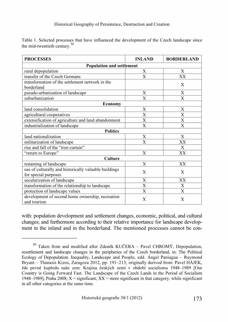
Historical Geography of Persistence, Destruction and Creation
Historická geografie 38/1 (2012) 173
Table 1. Selected processes that have influenced the development of the Czech landscape since the mid-twentieth century.30
PROCESSES INLAND BORDERLAND
Population and settlement
rural depopulation X X transfer of the Czech Germans X XX transformation of the settlement network in the borderland
X
pseudo-urbanization of landscape X X suburbanization X X
Economy
land consolidation X X agricultural cooperatives X X extensification of agriculture and land abandonment X X industrialization of landscape X X
Politics
land nationalization X X militarization of landscape X XX rise and fall of the “iron curtain” X “return to Europe” X XX
Culture
renaming of landscape X XX use of culturally and historically valuable buildings for special purposes
X X
secularization of landscape X XX transformation of the relationship to landscape X X protection of landscape values X X development of second home ownership, recreation and tourism
X X
with: population development and settlement changes, economic, political, and cultural changes; and furthermore according to their relative importance for landscape develop-ment in the inland and in the borderland. The mentioned processes cannot be con-
30 Taken from and modified after Zdeněk KUČERA – Pavel CHROMÝ, Depopulation,
resettlement and landscape changes in the peripheries of the Czech borderland, in: The Political Ecology of Depopulation. Inequality, Landscape and People, edd. Ángel Paniagua – Raymond Bryant – Thanasis Kizos, Zaragoza 2012, pp. 191–213; originally derived from: Pavel HÁJEK, Jde pevně kupředu naše zem. Krajina českých zemí v období socialismu 1948–1989 [Our Country is Going Forward Fast. The Landscape of the Czech Lands in the Period of Socialism 1948–1989], Praha 2008; X = significant; XX = more significant in that category, while significant in all other categories at the same time.
Zdeněk Kučera – Silvie Kučerová
Historická geografie 38/1 (2012) 174
sidered to be strictly distinct. Several of them took place concurrently or were followed by one another. Only a small number of the mentioned processes were also specific to the borderland. Despite this, we shall focus especially on their relationship to this territory in the following discussion.
As was indicated above, one of the most significant events that influenced the development of the borderland in the second half of the 20th century was the transfer of the Czech Germans. Similarly like other events in the past,31 this transfer has brought up questions about the significance of one event for the future directions of long-term transformations of certain landscapes. The processes of the transfer and subsequent resettlement of the borderland after World War II resulted in an almost total population exchange and meant a radical intervention into the society as well as tangible and intangible cultures of the borderland. As a result there was a loss of approximately 3 million permanent inhabitants,32 and large parts of mountain areas and of areas less favourable for agriculture were depopulated. Several hundred settlements were completely abandoned and deserted.33 Many empty buildings were preserved only due to the fact that they were transformed into second housing.34 Along with the original residents, the memory of the local landscape was also transferred. Those who resettled the borderland had to create new relationships to the environment into which they came. Although the transfer cannot be considered the direct cause of many of the later population, economic, social, and cultural changes, it had through the sudden interruption of the long-term continuity of settlement and of established ways of life contributed to these changes. New communities were, for example, created by settlers of various ethnicities and nationalities who were used to mutually different social and cultural norms and customs. This fact still in-fluences events in borderland regions, where there conflicts between different com-munities may arise. The transfer of the Czech Germans was the beginning of complex changes in landscape and in ways of life, which have resulted in differences between
31 Václav MATOUŠEK, Třebel. Obraz krajiny s bitvou [Třebel. The Image of Landscape
with Battle], Praha 2006. 32 Vladimír SRB, 1000 let obyvatelstva českých zemí [1000 Years of the Population of the
Czech Lands], Praha 2004. 33 David KOVAŘÍK, Proměny českého pohraničí v letech 1958–1960. Demoliční akce v čes-
kém pohraničí se zřetelem k vývoji od roku 1945 [Changes of the Czech Borderland Between 1958–1960. Demolition Actions in the Czech Borderland with Emphasis on Development after 1945], Brno 2006; compare Z. KUČERA, Zanikání sídel (see note 13).
34 Jiří VÁGNER – Dieter K. MÜLLER – Dana FIALOVÁ, Second home tourism in light of the historical-political and socio-geographical development of Czechia and Sweden, Geografie 116, 2011, pp. 191–210.
Historical Geography of Persistence, Destruction and Creation
Historická geografie 38/1 (2012) 175
the borderland and inland regions still visible in the organization of the landscape,35 population and cultural characteristics,36 and human and social capital.37
Other more general changes were caused by the coming of the Communists to power in 1948. Property ownership structure and agricultural production methods were transformed: agriculture was collectivized, private businesses were liquidated, land was consolidated, and agriculture was industrialized. In borderland areas at higher altitudes, signs of the extensification of agriculture started to appear in a still greater extent – a decrease of the area of arable land which has been substituted by forests and permanent grasslands. This is a trend that has continued even after 1990.38 The landscape was also influenced by continuing industrialization, growth in energy consumption, and resulting environmental stress.39 Due to Czechia’s position within Europe, landscape was militarized as well. In the 1950s along the western and southern state borders a closed-off zone was delimited in order to prevent crossing of the state border outside of the selected strictly guarded places. This area later became known as the “Iron curtain”.40
The landscape of the borderland continues to change after the start of democra-tization of the Czech society in 1989. Some of the hitherto closed and inaccessible areas were once again opened to the public, and interest in local heritage and land-scape was restored. Selected former military training areas were closed and their future use became a subject of debates.41 Tourism has developed in mountainous areas in particular due to their environmental potential.42 Activities of municipalities
35 R. RAŠÍN – P. CHROMÝ, Land use (see note 10). 36 Zdeněk KUČERA – Silvie KUČEROVÁ-KULDOVÁ, Designated landscape values versus
local attachment – A Preliminary survey, in: Venkov je náš svět / Countryside – Our World, ed. Věra Majerová, Praha 2008, pp. 108–120.
37 Vít JANČÁK – Tomáš HAVLÍČEK – Pavel CHROMÝ – Miroslav MARADA, Regional differentiation of selected conditions for the development of human and social capital in Czechia, Geografie 113, 2008, pp. 269–284.
38 Ivan BIČÍK – Leoš JELEČEK, Land use and landscape changes in Czechia during the period of transition 1990–2007, Geografie 114, 2009, pp. 263–281.
39 Jiří ANDĚL, Regions of environmental burden in the Czech republic – Methods of defini-tion, AUC – Geographica 29, 1994, pp. 111–125.
40 A. JÍLKOVÁ – T. JÍLEK et al., Železná opona (see note 18). 41 Tomáš SEIDL – Pavel CHROMÝ, Environmental conservation in military training areas
– source of spatial conflicts?, Europa XXI 21, 2010, pp. 103–115. 42 More than 40 % of the area of the resettled borderland is now included in some type of
protected area; Zdeněk KUČERA – Silvie KUČEROVÁ-KULDOVÁ – Pavel CHROMÝ, Land-
Zdeněk Kučera – Silvie Kučerová
Historická geografie 38/1 (2012) 176
and civic associations have gradually become focused on the restoration of local monuments. Occasionally, monuments are even being restored in cooperation with the former residents of German nationality. Despite this, many monuments, for example churches, have remained abandoned and in unfavourable conditions. There is no one to take care of them. In the areas where they are located live a lot less people than in the times when they were built. Moreover, the situation is not helped by the fact that the borderland is now one of the regions with the lowest share of religious inhabitants in Czechia.43 The sad paradox of the existence of some of these monuments is also the fact that while they have survived the com-munist period before 1989 in a relatively good shape, they were later damaged by vandals and thieves. The cultural landscape of the borderland and its memory are still changing.
Forms, functions, meanings and values
Every landscape not only develops under the influence of various processes. It is also made up of forms with which certain functions, meanings and values are associated. The landscape of the Czech borderland underwent many changes in the second half of the 20th century. Several forms, functions and values related with this landscape have remained preserved, and others have been replaced with new ones. In this part of the paper we shall focus on the discussion of some of them using the Žlutice micro-region as an example.
Based on the data contained in the database of land use in Czechia44 we can characterize the contemporary landscape of the Žlutice micro-region as being cultivated extensively. However, as the graph no. 1 indicates, in the first half of the 20th century the landscape of the micro-region was more open, with arable land and permanent grasslands dominating. During the 20th century the share of arable land decreased by nearly half, and the extent of forest and other areas grew. From fig. no. 245 it is clear
scape heritage between areal preservation and areal development – the case of Czechia, Geographia Polonica 81, 2008, pp. 5–23.
43 Tomáš HAVLÍČEK – Martina HUPKOVÁ, Religious landscape in Czechia. New structures and trends, Geografie 113, 2008, pp. 302–319.
44 Available at http://lucc.ic.cz/; compare Ivan BIČÍK – Lucie KUPKOVÁ, Dlouhodobé změny využití krajiny Česka: metody, výsledky, problémy výzkumu [Long-term land use changes in Czechia: methods, results, problems of research], HG 33, 2005, pp. 346–366.
45 The land use change index was calculated using data available at http://lucc.ic.cz/. The change index expresses on what percentage of a given territorial unit changes in land use occurred. For details see I. BIČÍK – L. KUPKOVÁ, Dlouhodobé změny (see note 44). For information about

Historical Geography of Persistence, Destruction and Creation
Historická geografie 38/1 (2012) 177
0%
10%
20%
30%
40%
50%
60%
70%
80%
90%
100%
1845 1948 1990 2000
remaining areas
built-up areas
water
forest
permanent grasslands
permanent cultures
arable land
Graph no. 1. Development of the land-use structure in the Žlutice micro-region between 1845 and 2000.46
that the transformation of the landscape of the Žlutice micro-region was not even. The largest changes can be noticed particularly in the northern and central parts of the area. This means in the parts from which the first was affected by the establishment of the military training ground in 1953 and the second by the con-struction of the water reservoir in 1968. In those parts fundamental landscape and settlement changes, which were accompanied with the disappearance of many settle-ments, took place. Despite this, even the total scope of post-war transformation of the micro-region cannot be underestimated. The extent of the changes is indicated for example by the fact that whereas in 1930 there were 27,000 residents present with an average population density of 55 people/km2, in 2001 the average population density was only 20 people/km2 and only 10,000 people resided here permanently.47
the localization of the deserted settlements see Z. KUČERA, Zanikání sídel (see note 13) and http://www.zanikleobce.cz.
46 Authors’ analysis based on the data available at http://lucc.ic.cz/. 47 The presented information about population changes comes from the analysis of data
from the following publications: Statistický lexikon obcí v zemi České, úřední seznam míst podle zákona ze dne 14. dubna 1920, čís. 266 sb. zák. a nař. Vydán ministerstvem vnitra a Státním úřadem statistickým na základě výsledků sčítání lidu z 1. prosince 1930 [Statistical Lexicon of Municipalities in the Bohemian Land, The Official List of Places According to the Act from April 14, 1920, No. 266 of Collection of Acts and Provisions. Issued by the Ministry of the Interior and State Statistical Office on the Basis of December 1, 1930 Census Results], Praha 1934; Seznam obcí v zemi České podle stavu z prosince 1945 [The List of Municipalities in the Bohemian Land as of December 1, 1945], Zprávy Státního úřadu statistického republiky Československé XXVII,
Zdeněk Kučera – Silvie Kučerová
Historická geografie 38/1 (2012) 178
The greatest population decline occurred between 1945 and 1946, when the popula-tion decreased by approximately 16,000. Rural towns, i.e. main centers of the region, and settlements located on the most important transportation lines were the most successfully resettled. Settlement structure has changed completely. Whereas in 1930 there were very few settlements with less than 25 inhabitants, in 2001 this type of settlements prevailed. Population changes thus became along with other social, eco-nomic, and political events one of the most important driving forces of the landscape changes in the Žlutice micro-region.
Cultural changes however were also an significant part of the transforma-tions of the area. These manifested themselves not only in the modification and dis-appearance of structures considered to be important by the former German population, but also in their renovation and in attempts to (re)interpret and to come to terms with past events through the creation of new structures (see fig. no. 3, 4). Commemorative sites in particular, such as for example memorials and cemeteries, and sacral structures have become a part of the debates concerning the transformations of values and meanings associated with the cultural landscape of the borderland.48 Using the Skoky pilgrimage site as an example, changes in the physical condition, functions, and meanings of such structures are described in the following text. In order to fulfill this goal, findings collected from various sources, knowledge based on interviews conducted in spring 2011 and on field observations will be used.
The Skoky pilgrimage site is located in the central part of the Žlutice micro-region, i.e. in the part whose character was significantly changed by the construction of the water reservoir in the 1960s (see fig. no. 2). This two-tower pilgrimage church built on the site of an original chapel in 1736–1738,49 is located on an elevated point in the middle of the deserted village (see fig. no. 5). Together with the remains of another
Řada D, číslo 1–16, [Reports of the Czechoslovak State Statisical Office XXVII, Series D, nos. 1–16] Praha 1946; Seznam obcí v republice Československé. Díl I. Seznam obcí v zemi České podle stavu z konce roku 1946 [The List of Municipalities in the Czechoslovak Republic. Part I. The List of Municipalities in the Bohemian Land as by the End of the Year 1946], Praha 1947; Statistický lexikon obcí České republiky 2003. Podle územního členění státu k 1. 1. 2003 a výsledků sčítání lidu, domů a bytů 2001 [Statistical Lexicon of Municipalities of the Czech Republic 2003. Based on the Territorial Division of the State as of January 1, 2003 and on the Results of the 2001 Census], Praha 2004; Jiřina RŮŽKOVÁ – Josef ŠKRABAL et al., Historický lexikon obcí České republiky 1869–2005. I. díl [Historical Lexicon of Municipalities of the Czech Republic 1869–2005, Part I], Praha 2006.
48 This is similar to other parts of Central Europe affected by the transfer of the German population, see for example Dagmara CHYLIŃSKA, Trudne dziedzictwo – cmentarze poniemieckie w krajobrazie kulturowym Dolnego Śląska [Dissonant heritage – Former German cemeteries in the Lower Silesia cultural landscape], ArchK 2007, pp. 31–39.
49 Zdeněk BOHÁČ, Poutní místa v Čechách [Pilgrimage Sites in Bohemia], Praha 1995.
Historical Geography of Persistence, Destruction and Creation
Historická geografie 38/1 (2012) 179
building, a former inn, it serves as a reminder of the past glories of the pilgrimage site. It used to be known throughout all of Bohemia and the local pilgrimage tradition was, in combination with a special technological solution of the movement of the holy picture during pilgrimage masses leading to its unintended jumping while moving, responsible for the creation of the famous saying: “Panenko Skákavá!” (Jumping Virgin! – this is directly associated with the Czech name of the site, Ma-riánské Skoky, which may be loosely translated in English as Marian Jumps and was derived from the former German name of the village, Mariastock). Hardly anyone
Zdeněk Kučera – Silvie Kučerová
Historická geografie 38/1 (2012) 180
though now directly links this saying to the pilgrimage site in Skoky. Today, the access to the pilgrimage site is more difficult than it used to be in the times when the village was inhabited permanently. The only road that led there was flooded by the water reservoir. The site is accessible only along field paths from nearby villages. However, in spite of its location in an isolated spot, it has not been completely abandoned. It lives on in the memories of those who used to make the pilgrimage here, and its present plight is being publicized and dealt with by a civic association from a nearby small town.50 Not only are pilgrimage masses held here regularly, but also other social and cultural events take place in Skoky, mainly during the summer tourist season. There is no lack of visitors during these events. Despite the remoteness of the site, the “unattractiveness” of an empty, altar-less church looted during the 1990s, and the fact that it is difficult to get here. For example on the day of the main religious pilgrimage in the spring of 2011, about 300 people came. Czechs and Germans of various age groups met here. Everyone who came took part in the religious celebra-tions, even though they were not primarily searching for faith. On the day of the pilgrimage there was a bus for pilgrims that, starting at the monastery in Teplá, drove around the region and brought people without their own transportation as close as possible to the pilgrimage site. The route of this special bus symbolically followed the pilgrimage route connecting the church in Skoky with its administrative headquarters. This pilgrimage route was created as a part of the project organized by the civic association, the goal of which is to support tourism and regional awareness.
The example of the Skoky pilgrimage site shows that the transformation of symbolic places in the borderland has not always led to their total destruction and abandonment. However, preservation of such places is often accompanied by their reinterpretation and by at least partial transformation of their symbolic content and function. This is reflected in the activities and statements of those who take care of such places. In the case of Skoky it was necessary for the civic association to start a discussion about why the church was in serious disrepair and what were the pos-sibilities for its future use. Thus perhaps the administrator of the church, the monastery in Teplá, sees a need to non-violently address people who have no direct relation-ship with the church and who are not religious, but who may care about cultural heritage. A representative from the monastery stated during an interview: “Overall I try to be realistic. Pilgrimages, the way that they used to be (…) today are some-where completely different. Here by us the Skoky, its glory (…) is gone, and won’t be restored. It is more of a place where people can meet with God through Mary. There’s a centuries-old tradition there (…), so it’s more of a conception (…), that various activities that are there are not just spiritual, and actually it is cultural activities that dominate, like concerts and performances (...). I view this here in the borderland
50 See http://www.skoky.eu.
Historical Geography of Persistence, Destruction and Creation
Historická geografie 38/1 (2012) 181
region as the content of the pilgrimages, (…) that it gives people here a lot more, or it addresses them. (...) Religious non-believers, lots of people more or less like monu-ments and want to help that site, not out of some religious conviction, but I’d say that the people that do there something, that most of them are not involved in the church, but the fate of the site is not indifferent to them. They know that it is an in-credible building. They respect it and want to preserve its value for future generations. Therefore, there is a noble idea behind it all. (...) I think this is where the path is leading. I mean here in our regions where traditions have been severed, interrupted.”
Borderland landscape as palimpsest and multihistoric heritage
The landscape of the Czech borderland underwent many changes in the second half of the 20th century. Like every landscape, the contents of this one too refers to past events and times. In this sense it is a palimpsest51 and a multihistoric heritage,52 which is constantly undergoing development and (re)interpretation. Changes in the landscape of the borderland were caused by general processes, taking place on the entire territory of Czechia, as well as by events specific for the borderland. With the transfer of the Czech Germans after World War II not only the continuity of its cultivation and interpretation was broken. The overall number of its inhabitants also decreased. Especially poorly accessible areas with less favourable conditions for agriculture remained unsettled. As a result of post-war changes many settlements in the borderland disappeared. With the change of the political regime at the start of the 1950s many areas directly on the border were completely closed to the public. Along with the population transfer there was a significant cultural change. The new residents, the settlers, who brought with them their own ways of life, customs, traditions and values, had to conform to living in a new environment as well as they have in many ways adapted the landscape that was new to them according to their needs. The political and social changes associated with the democratization of the Czech society after 1989 represented a certain break in borderland landscape develop-ment. Dynamic changes took place particularly in border mountain regions, where there new possibilities for the development of tourism and cross-border contacts opened up.53 In addition, there has been gradual growth in the interest of local com-
51 M. GOJDA, Archeologie (see note 24). 52 Karoline DAUGSTAD – Eir GRYTLI, How to study and manage a multihistoric land-
scape, Norsk Geografisk Tiddskrift 53, 1999, pp. 85–92. 53 Compare Milan JEŘÁBEK – Jaroslav DOKOUPIL – Tomáš HAVLÍČEK et al., České po-
hraničí – bariéra nebo prostor zprostředkování? [Czech Borderland – Space of Barrier or Mediation?], Praha 2004.
Zdeněk Kučera – Silvie Kučerová
Historická geografie 38/1 (2012) 182
Historical Geography of Persistence, Destruction and Creation
Historická geografie 38/1 (2012) 183
munities to understand the transformations of their regions in the entire borderland. The aim of these activities however is not to return the landscape its original character, but to create a relationship with certain historical and intergenerational continuity to the lived-in landscape. The landscape of the borderland changed irreversibly during the second half of the 20th century. In some parts of the borderland landscape character changed fundamentally. Although some old elements disappeared, the landscape was enriched with new structures, values and ideas. Despite the post-war population ex-change, the landscape of the borderland still remains inhabited. This is a point which mutually connects not only its residents, but also many studies on the borderland.
Zdeněk Kučera – Silvie Kučerová Historická geografie přetrvávání, zkázy a obnovy: případ proměn venkovské krajiny dosídleného pohraničí Česka
Příspěvek se zaměřuje na diskuzi proměn venkovské krajiny pohraničí v období druhé poloviny 20. století. Pohraničím se zde rozumí území souvisle přiléhající k hranici Česka, na němž v roce 1930 převažovalo obyvatelstvo hlásící se k německé národnosti. Jedná se přibližně o oblast, jež byla po skončení druhé světové války postižena výměnou obyvatel-stva v souvislosti s odsunem českých Němců. Nejvýznamnější procesy ovlivňující fungování zdejší krajiny jsou v příspěvku nejen charakterizovány, ale jejich důsledky jsou též přiblí-ženy s využitím příkladu modelového území Žluticka. Pozornost se věnuje (a) formám, (b) funkcím, (c) procesům způsobujícím změnu zdejší krajiny, (d) kontextu, v němž se změny odehrávají, (e) krajinným významům a hodnotám a jejich proměnám.
Krajina pohraničí svým obsahem odkazuje na minulé události a období a je v tom-to smyslu palimpsestem či multihistorickým dědictvím, jež podléhá neustálému vývoji a (re)interpretaci. Její změny byly způsobeny jak obecnými procesy, uplatňujícími se na celém území Česka, tak událostmi pro pohraničí specifickými. S odsunem českých Němců došlo k přerušení kontinuity v její kultivaci a interpretaci. Zejména hůře přístupné oblasti s méně příznivými podmínkami pro zemědělství zůstaly nedosídlené. V důsledku pová-lečných změn mnoho sídel v pohraničí zaniklo. Se změnou politického režimu na počátku 50. let 20. století byly některé příhraniční oblasti veřejnosti zcela uzavřeny. S výměnou obyvatel pohraničí je spojená i významná kulturní změna. Dosídlenci se museli přizpůsobit životu v novém prostředí a také si v mnohém pro ně novou krajinu přizpůsobili. Určitý zlom ve vývoji krajiny pohraničí znamenaly politické a společenské změny po roce 1989. Postupně se rozvíjí zájem místních společenství o poznání proměn svých regionů. Cílem těchto aktivit ovšem není vrátit obývané krajině její původní ráz, ale vytvořit si k ní určitý vztah s historickou a mezigenerační kontinuitou. Krajina pohraničí se nenávratně změnila. Zůstává však krajinou obývanou. Něčím, co vzájemně spojuje nejen své obyvatele, ale též mnoho studií na téma pohraničí.
Zdeněk Kučera – Silvie Kučerová
Historická geografie 38/1 (2012) 184
HISTORICKÁ GEOGRAFIE 38/1 (2012)
http://www.hiu.cas.cz/cs/mapova-sbirka/historicka-geografie.ep/
185
Aleš Nováček*
HISTORICAL-GEOGRAPHICAL ASPECTS OF DUALITY IN EUROPE
Keywords
Abstract
Europe West East duality historical-geographical
aspects development
The article is based on the hypothesis that Europe has been historically and permanently “divided” into two parts. Four historical-geographical aspects of this duality are distinguished: cultural, economic-social, political, and ethnic. To examine and define duality, specific indicators are used. Duality is under-stood as a complex and dynamic phenomenon that changes over the time. Conclusions summarize briefly the historical synthesis.
* PhDr. et RNDr. Aleš Nováček, Ph.D., University of South Bohemia – Pedagogical faculty,
Department of Geography, Jeronýmova 10, České Budějovice, CZ – 371 15. E-mail: anovacek@ pf.jcu.cz. – This paper is based on the results of research projects supported by the Grant Agency of the Czech Republic No. P410/12/G113.
Aleš Nováček
Historická geografie 38/1 (2012) 186
Introduction
World War I, World War II, bipolar world, disintegration of the Eastern Bloc, advancing institutional integration of Western Europe – these are the most im-portant recent events and processes that are considered to have shaped the present-day Europe. However, there are also much older “fundaments” that have been affecting geographical and spatial organization of Europe since centuries ago. The author’s broader research has been focused on these fundaments.1 Especially his-torical-geographical aspects of duality in Europe have been examined and analyzed, using the basic hypothesis of historical division of Europe into two parts.
The division of Europe into two subregions has been until recently understood in contradictory terms: free-market and democratic West versus socialistic and totali-tarian East. Such a dualist perception of Europe became prevalent after World War II, in geopolitical concepts and scientific literature, but also in common use. Though the European bipolarity began to loose its strict, clear contours after 1989, the con-cept as such did not cease to exist (alternative approaches naturally developed, too). Among the reasons for this are recent historical experiences as well as the fact that a sort of duality in Europe can be traced since many centuries ago, possibly since antiquity. From the historical perspective, the present era may be characterized by a lot of dynamism which includes the transformation of Central Europe and its gradual move towards the West. In other words, duality in Europe is a highly current topic and there are good reasons to understand reasons and processes that shaped it.
Most scholars examining the European duality and its historical-geographical aspects have so far focused mostly on the 20th century,2 alternatively on the position of Central Europe – whether it is historically closer to the East or to the West or
1 Aleš NOVÁČEK, Dualita Evropy. Historickogeografická analýza [Duality in Europe. His-
torical-geographical analysis], Praha 2012; Aleš NOVÁČEK, Dualita Evropy. Historickogeogra-fická analýza vývoje a její vymezení [Duality in Europe. Historical-geographical analysis of the development and its delimitation], dissertation, PřF UK, Praha 2010.
2 Among the examples are works where the division Eastern versus Western Europe is part of regional division of the world: John COLE, Geography of the World’s Regions, New York 1996; Martin HAMPL, Globální systém. Stav, současné tendence a možné perspektivy distribuce mo-cenského potenciálu [Global System. Situation, Current Trends and Possible Prospects for the Distribution of Power Potential], Geografie 114, 2009, No. 1, pp. 1–20; Samuel HUNTINGTON, The Clash of Civilisation and the Remaking of the World Order, New York 1996; Bruce RUSSETT, International Regions and the International System. A Study in Political Ecology, Chicago 1967. Another group consists of studies that examine the duality in Europe on the base of selected aspects, for instance: Derek ALDCROFT – Steven MOREWOOD, Economic Chase in Eastern Europe since 1918, Aldershot 1995; Terry JORDAN, The European Culture Area, New York 1996.
Historical-geographical Aspects of Duality in Europe
Historická geografie 38/1 (2012) 187
whether it rather creates a self-contained region.3 Only very few scientific studies look at longer periods of time and these usually examine just one aspect of duality (for instance culture or religion). Consequently, such a single aspect is used as a base on which historical-geographical division of Europe is constructed.4 Static and cross-section approaches are mostly used with little or no attention to long-term trends and complex changes of geographical organization. Thus, the dynamic approach towards duality concept is usually absent.5
3 Includes, among others, the historic German concept of Mitteleuropa advocated in the work
of Friedrich NAUMANN, Mitteleuropa, Berlin 1915. Other works: Otto FORST de BATTAGLIA, Zwischeneuropa, Geographisches Rundschau 12, 1960, pp. 305–317; István BIBÓ, Bída malých národů východní Evropy [The Distress of the East European States], Brno – Bratislava 1997; Norman DAVIES, Europa miedzy wschodem a zachodem [Europe East and West], Kraków 2007; Oskar HALECKI, Historia Europy – jej granice i podzialy [The Limits and Divisions of European History], Lublin 2000; Hans LEMBERG, Porozumění. Češi – Němci – východní Evropa 1848–1949 [Com-prehension. Czechs – Germans – Eastern Europe 1848–1949], Praha 2000; Jenö SZÜCS, Tri historické regióny Európy [Three historical Regions of Europe], Bratislava 2001; Piotr WANDYCZ, Střední Evropa v dějinách od středověku do současnosti: cena svobody [The price of freedom. A history of East Central Europe from the Middle Ages to the Present], Praha 2004. Czech (Czech/ French) authors that examined this topic include: Milan KUNDERA, Únos západu aneb Tragédie střední Evropy [The Stolen West or The Tragedy of Central Europe], Proměny 23, 1986, No. 1, pp. 134–147; Oskar KREJČÍ, Geopolitika středoevropského prostoru. Pohled z Prahy a Bratislavy [Geopolitics of the Central European Region. The view from Prague and Bratislava], Praha 2010; Jan KŘEN, Dvě století střední Evropy [Two Centuries of Central Europe], Praha 2005; Jacques RUPNIK, Jiná Evropa [Other Europe], Praha 1992; Jiří STEHLÍK, Zařazení České republiky v evropském prostoru [Place-ment of the Czech Republic in the European area], Mezinárodní vztahy 2, 1996, No. 2, pp. 95–106.
4 Cultural and religious aspects as main determinants of European duality should be mentioned in connection with Weber’s work: Max WEBER, Die protestantische Ethik und der Geist des Kapitalismus, Tübingen 1934. Europe is divided by religious, languague and race lines in the above mentioned work by T. JORDAN (see note 2); religion is seen as a crucial aspect by S. HUN-TINGTON (see note 2). When it comes to practical politics, the Curzon Line (demarcation line between Poland and Russia, drafted by the Allies after World War I and de facto adopted after World War II), was based on cultural, ethnic and religious differences. Other autors consider economic inequalities to be crucial for the division of Europe, among others: Daniel CHIROT, The Origins of Backwardness in Eastern Europe. Economics and Politics from the Middle Ages until the Early Twentieth Century, Los Angeles – Oxford 1991; Jaroslav PURŠ, Průmyslová revoluce. Vývoj pojmu a koncepce [Industrial Revolution. The Development of the Term and Conception], Praha 1973; Immanuel WALLERSTEIN, The Modern World-System, Vol. I. Capital Agriculture and the Origins of European World-Economy in the Sixteenth Century, New York – London 1974. A very special historical concept of duality presents the so called Hajnal Line which puts a dividing line between two generalized European family forms called north-western and south-eastern (see note 14).
5 Among the exceptions that incorporate the changing character of reality into the duality con-cept belong among others: Geoffrey BARRACLOUGH, Eastern and Western Europe in the Middle
Aleš Nováček
Historická geografie 38/1 (2012) 188
The author has focused his research on European duality on several sub-fields; recently he has finished publication on this topic which is based on dissertation6 defended at Faculty of Science, Charles University, Prague. The main goal has been to reveal, define and delimit the duality in Europe based on long-term historical-geographical analysis. First, the concept of European duality has been formulated; duality is approached as a complex and spatially dynamic phenomenon. Second, individual historical-geographical aspects of duality were structured and given hierarchy. Third, an appropriate method suitable for analysing the duality in histori-cal regions in different years has been applied. On this base the main duality border was constructed and fourteen overview historical maps were created. Fourth, attention is given to synthesis, generalization, and explanation of long-term processes and trends in the duality in Europe including key causal processes. Thus, it has been attempted to reveal roots of the present state and development. The European duality was exami-ned in its entire time span, i.e. possibly since around 500 BC till present.7 Given the long time scope and large space involved, the research was based on interdisciplinary historical-geographical approach – the one that integrates methods and discoveries from the fields of geography, history, and other branches of social sciences.
Using the above mentioned methods, various historical-geographical aspects and indexes are briefly shown in order to define and examine the duality in Europe in the past and present. Their systematization, structuring, and hierarchization were parts of the conceptual definition of duality and also the base for time analysis. Results of this analysis which combined quantifications with “soft” approach served as a base for delimitation of European duality.
Defining the aspects of duality
Various sources dealing with East-West duality in Europe generally agree on the fact that both parts differ from each other in economic standards and also in the degree of democracy. This state of affairs is often related with membership (or non-membership) in international organizations like EU or NATO. As stated above, scholars most often seek for reasons that caused this situation in the second half of 20th century, namely during the 40 years division of Europe. These explanations are often cited in works that lack deeper historical investigations and also in media.
Ages, London 1970; Werner CAHNMAN, Frontiers between East and West in Europe, Geo-graphical Review 39, 1949, pp. 605–624; of Czech authors for example: Oskar KREJČÍ, Meziná-rodní politika [International Politics], Praha 1997.
6 See note 1. 7 In the analysis the whole time scope has been divided into 14 cross-sections.
Historical-geographical Aspects of Duality in Europe
Historická geografie 38/1 (2012) 189
Authors who adopt a sound historical approach usually refer to the split of Roman Empire and to the rise of Byzantine and Frankish Empires and Holy Roman Empire as to main causes of the current East-West duality. Schism within the Church is often mentioned, too, as is the exposure of Eastern Europe towards Asian influences and the clashes between Germanic and Slavic peoples in Central Europe. Economic and social matters that may have influenced the increasing differences between East and West include: different status of serfs, importance of cities, gradual shift of European core area towards the Atlantic coast as a result of the Age of Discovery, consolidation of the global core-periphery system, and Industrial Revolution. Some authors also mention the North-South duality and refer to the heritage of ancient civilizations connected with Romanic languages and Romanic culture, to the contrasts between Catholic and Protestant religions, and also to different philosophical back-ground and working habits. Geographical determinism is sometimes cited as a phe-nomenon that contributed to both versions of duality, too.8
These are just a few examples from a more complex ensemble that consists of mutually connected and dependent causes, aspects, and determinants that con-tributed to the duality. The whole can be divided into several groups: cultural, eco-nomic-social, political, and ethnic aspects of duality. These groups represent parts of reality where duality in Europe can be examined and defined. Each realm features concrete aspects that can be studied using selected indicators (duality indicators).9
The influence of each factor and the validity of indicators with regard to dua-lity in Europe have changed over the time. Indicators and factors were examined thoroughly in order to define their importance for European duality in different years – in such a way they form a compact system reflecting continuity. The four aggre-gated aspects of duality were evaluated and hierarchized in the same manner. Factors and indicators as parts of duality aspects and their significance in each time cross-section are shown in Tables 1 and 2. In the following text the four aggregated aspects of duality are examined in more detail.
8 Different climatic patterns are important in the case of east-west orientation (maritime vs. continental climate). On the north-south axis, different climatic zones can be observed (temperate vs. subtropical zones). These natural differences influenced greatly economic activities and well-being of European societies especially in early periods. The north-south duality can be observed also when physical features are taken into account: mostly mountainous south differs from largely flat north.
9 The cultural aspect, for instance, includes religion. The duality of religion is clear when the share of different denominations is examined. The selection of factors and indicators discussed in the following text reflects the analytic demands. The importance of each factor (indicator) with regard to European duality was thoroughly examined. Data availability was an important criterion, of course, as was the possibility to compare data from different time cross-sections. Only part of the data has a quantitative character, i.e. is based on statistical records or estimates. Other informa-tion has been derived from historic facts, maps, and atlases.
Aleš Nováček
Historická geografie 38/1 (2012) 190
Cultural aspect As “culture” has had a changing character over the time, the cultural aspect can be understood in different ways. In antiquity, cultural and civilization differences reflected the north-south duality. In the Middle Ages and Early Modern Era “culture” was perceived in cultural and religious terms; during the secular 19th and 20th centuries one can already talk about “pure culture”. The cultural aspect had played a key role in defining of European duality in antiquity and in the Middle Ages; later, however, its importance declined. At the present time the cultural aspect plays only a minor role because cultural unification in Europe is as high as never before.
Different parts of Europe have shown striking cultural differences (cultural standards) over long periods of time. These differences rather reflect the so-called secondary duality defined as differences between more and less developed regions.10 In this case it is the duality between the highly developed, “creative” core on one side and backward, more passive periphery that rather accepts cultural trends coming from the core on the other side. In practice the general cultural level can be examined by the existence of material (written) documents or artistic artefacts. In the Industrial Age the contradiction between “modern” and “traditional” comes on the scene.
The degree of cultural influence typical for different parts of Europe can be understood as a complementary indicator that helps to define the European duality. This is the so-called primary duality that can be seen as a relation between two self-contained, homogeneous and equally important regions with own core areas.11 Such relations existed between the Western and Eastern cultural realms in the Middle Ages, to a certain extent also in Early Modern Era. In antiquity as well as during the Industrial Age the Western (Classical) culture and mentality were dominant and superior.
On similar grounds the cultural duality can also be examined from the degree of Oriental influence.12 Originally non-European (Eastern, Asian) ideas and in-fluences became integral parts of East European culture especially during Late Middle Ages and Early Modern Era. This period is characterized by intensive merging of Western and Asian elements with domestic East European traditions.
There is no doubt that religion (or rites) played a decisive role in the process of forming European duality. Many authors see the schism within the Church as the most important event that predetermined the future differences between East and West. Religion typically created the primary duality and also multiplied the identity
10 This article deals with two duality types, primary and secondary. Details are discussed in
the final section. 11 See previous note. 12 Ideas and aspects typical for Orient (Asia) that include the spread of Islam and despotic
rule as well as appearance of artistic styles and monuments common in Oriental countries.
Historical-geographical Aspects of Duality in Europe
Historická geografie 38/1 (2012) 191
having direct influence on culture, mentality, language, national psyche, and state organization. Unlike with other cultural aspects, empirical data on religion (percentage/ number of believers) is often available. The religious division of Europe had had a determining influence on European duality especially in the Middle Ages; later the importance of religion slowly declined.13
Some more cultural aspects, less often cited and examined, should be men-tioned here. Among these are two prevailing traditional family forms as defined by John Hajnal, British demographer and historian with Czech ancestry. He studied different family sizes and marriage patterns and generalized two European traditional family forms called north-western and south-eastern. Differences between the two had been clear in between the 16th and early 20th centuries; later the distinction blurred due to ongoing cultural unification.14
Economic and social aspects Unlike the cultural aspects, economic and social aspects rather evoke secondary duality, i.e. differences among advanced and backward regions. The influence of economic and social aspects on European duality tends to increase over the time; during the Modern Era these aspects seem to be the decisive ones. Economic and social indicators can be measured (quantified) in a relatively precise way; statistical data and qualified estimates are often used. The selection of indicators largely depends on availability of appropriate databases.
As far as the pre-industrial period is concerned, the selection of duality indicators is naturally connected with the core-periphery system. Population density is an example. It has been assumed that higher population concentrations were closely related to higher economic activity, power centres, and also to more progressive social organization. Urbanization level serves as a similar type of indicator. The existence of cities and towns automatically brought more non-agricultural activities and such settlements consequently became symbols of economic, social and political progress. Since the 19th century urbanization is also seen as an indirect indicator of modern lifestyle – urbanized society.
13 The aspect of religion, seen from the present-day perspective, also includes different
religiosity in different parts of Europe. At the present time religiosity seems to be linked to the North-South duality. It is difficult, however, to trace religiosity in the past and hence historic comparison is statistically nearly impossible.
14 John HAJNAL, Two kinds of pre-industrial household formation system, in: Family forms in historic Europe, edd. Richard Wall – Peter Laslett – Jean Robin et al., Cambridge 1983, pp. 65–104. The dividing line between the two models (so-called Hajnal’s Line) was drawn between Saint Petersburg and Trieste, with certain exceptions: Ireland, Finland and parts of Mediterranean were closer to the south-eastern type of multi-generation family.
Aleš Nováček
Historická geografie 38/1 (2012) 192
When it comes to the Industrial Age, the share of labour force (SLF) outside the primary sector seems to be an appropriate indicator. Such data is readily avail-able; moreover, due to more advanced agricultural methods the rural communities became less and less agrarian. Thus, SLF outside the primary sector helps to draw the dividing line between industrial and agrarian parts of Europe. The share of labour force in tertiary and quarternary sector reflects the differences among economic systems since the early 20th century and marks the transition towards the post in-dustrial society. The latter indicator, however, should be used with care especially for the period 1945–1989.
Gross domestic product (GDP) per capita is another suitable indicator, closely connected to standard of living and economic prosperity. It helps when the core-periphery relations are studied as well as when the “advanced-backward” duality comes into question.15 When the above mentioned economic and social indicators are summarized and interpreted, general economic levels can be compared and the position of different regions within the core-periphery system can be assessed – for instance the role in long-distance trade or in labour specialization.
As cultural aspects became less important during the 19th century, the Euro-pean duality has taken the shape of “advanced vs. backward” form. Most of the above mentioned factors and indicators that help to define the European duality can be used across the time. On the contrary, some other indicators like spread of western-type towns or expansion of universities and printing apply to selected periods only – from High Middle Ages till Early Modern Era, i.e. before such institu-tions and skills became common. Of course, the latter examples are of western origin and their gradual diffusion reflects unequal level of contacts among Central and Western European regions.
Social and economic relations are also important when economic and social aspects of duality are studied. For instance, different types of feudalism existed in Europe in the Middle Ages and Early Modern Era; also the social status of serfs varied as did the prevailing type of landownership. Many of such phenomena showed a pronounced north-west vs. south-east polarity.
Level of industrialization reflects well the social and economic relations during the Industrial Age (between early 19th and mid-twentieth century). In the course of this period Europe was clearly divided into advanced (industrial) and backward (mostly agrarian) parts. Three indicators can be used here: index of industrial production per capita, share of labour force in the secondary sector, and existence of railways. Statistical records from this relatively recent period provide also other indicators, not necessarily purely economic ones: illiteracy rate or life expectancy. Both tell a lot about the social development. Since World War II a composite statistic
15 Estimates are available since about early 16th century.
Historical-geographical Aspects of Duality in Europe
Historická geografie 38/1 (2012) 193
called Human Development Index16 came to use. Many other “modern” indicators are readily available, of course, for instance the car ownership (number of motor vehicles per 1,000 people). The latter reflects well-being and indirectly also lifestyle – both are factors that help to detect the duality in Europe.
Political aspects The third basic aspect of duality is the political one. It shows more features of pri-mary duality and can be examined mostly using the “soft” data and comparative studies. Compared to cultural and social-economic aspects, politics had long seemed to play a minor role in defining the European duality, at least seen from the his-torical perspective. This situation, however, has changed profoundly after World War II – in the following years, on the contrary, politics took the decisive role as regards duality aspects and it partly retains its importance at the present time, too.
Degree of political organization of the society,17 the first one of selected political factors, is a sort of an exception as it rather shows the secondary type of duality. Historically, it was important especially in antiquity and Early Middle Ages when first states and state-like regions were formed: in that time a clear North-South division existed. Political status is another aspect to be considered and can be traced during the long period from antiquity till the present time. “Status” involves relations towards a superior power representing political core within the given region.18 Such superior European powers included: in the South the Roman Empire; in the West the Frankish Empire, the Holy Roman Empire and modern Western European powers (Great Britain, France, German Empire); in the East the Byzantine Empire, the Ottoman Empire, and Russia. The factor of political status is complemented by power relations and prevailing political (strategic, economic) orientation. After World War II membership in supranational organizations (politi-cal, economic) became highly important. Thus, Western countries were typically NATO and EU members, with strong relations with the USA. On the contrary Eastern countries were Soviet-dominated, members of Warsaw Pact and Comecon. The dividing line between the above political and economic organizations was the most important boundary in the post-war Europe.
16 Human development index (HDI) has been widely used in geography and economics when
quality of life is to be assessed. It is a comparative measure of life expectancy, illiteracy and GDP per capita.
17 It roughly reflects the following hierarchy: family system – tribal system – tribal union – city state/realm with no strict internal organization – centralized and well organized state.
18 Political status can include the following: part of sovereign state – dependent territory – independent region.
Aleš Nováček
Historická geografie 38/1 (2012) 194
A whole bunch of factors can be used when European duality is examined in the Modern Era. These include system of government (political regime), degree of political freedom, and individual human rights. Many other indicators and principles are often used in this context: concentration of political power and power sharing, constitutional system, stability of political system, minority policies, existence of democratic institutions, economic freedom, corruption index, etc. When these factors are taken into consideration, in most cases the European duality shows east-west (more precisely northwest-southeast) orientation. In other words: in the course of 20th century Europe was more or less divided into democratic and free West vs. autocratic and less free East.
Studies of European duality should also include the influence of non-Euro-pean powers (Tatars, Turks) in certain parts of Europe. These invasions occurred especially in the Middle Ages and Early Modern Era, were usually limited in terms of time and resulted in “lower civilization level” in the European East. Ideology is another factor to be considered as it influences political and economic character of state. Ideology was especially important in the period 1945–1989, i.e. in the period when political aspects of duality prevailed.
Ethnic aspect The ethnic aspect – when related to duality in Europe – is the only purely supple-mentary one. Along with cultural and political aspects it corresponds to primary duality and it always reflects the territorial share of ethnic groups that were identified as crucial for the identity of various parts of Europe. These groups include: Hellenistic and romanized peoples (antiquity; South); Latin (Romance) and Germanic ethnic groups (up to the Industrial Age; West); and Greek and Slavic peoples (up to the Industrial Age; East).19 With the emergence of modern nations a more complex categorization of ethnic groups using more attributes is needed.20
19 The ethnic aspect was quite often cited by scholars who studied the East-West duality
especially before 1945. In the 19th century Central Europe ethnicity and nationalism were seen as key aspects of national history – this approach was adopted among others by Leopold von Ranke or František Palacký. Also some post-war scholars argued that Slavic peoples formed one of the cornerstones of European East (together with Orthodox Church). Some other, usually less populous Eastern European nations (Lithuanians, Latvians, Estonians, Hungarians, or Romanians) were often perceived as being part of “Slavic history”, i.e. part of European East – though most of these nations had historically strong cultural and religious relations with the West (Romanians excluded).
20 For more details regarding categories and differences among ethnic groups in relation to duality in Europe see A. NOVÁČEK, Dualita Evropy (see note 1).
Historical-geographical Aspects of Duality in Europe
Historická geografie 38/1 (2012) 195
Conclusions
The above mentioned factors and indicators constitute detection and conceptual framework of duality. They have been structured into four historical-geographical aspects in order to study the duality in more detail, to analyze and delimit it. Among the number of results brought by this research the long-term development of duality in Europe can be summarized in two syntheses.
First, two types of duality have been examined. These were described as primary and secondary dualities – in praxis, though, they were always closely inter-twined. The primary duality indicates relations between two self-contained and more or less equal regions, each with its own core. On the contrary, unequal relations between two regions are typical for the secondary duality: one region, featuring own core area, is more developed than the other one which is weaker or dependent. As stated above, cultural, political, and ethnic aspects rather tend to create primary dua-lities, while economic and social aspects often imply secondary dualities. Over the course of time the European duality more often showed elements of secondary dua-lity. In antiquity and Early Middle Ages the North-South (secondary) duality pre-vailed, sometimes in an extreme form. The East-West polarization became to emerge during Early Middle Ages and was much influenced by political and religious rivalry between the Frankish Empire (later Holy Roman Empire, pope) on one side and the Byzantine Empire on the other side. East and West gradually formed two equally strong European regions featuring at first mostly primary type of duality. Roughly around the end of 13th century the ratio between primary and secondary dualities had become balanced and later secondary dualities began to dominate. Among the reasons was better economic performance of the West accompanied by stagnation in the East.21 Later, the long-time dominance of secondary duality was twice dis-rupted. In both cases this disruption occurred when Russia became (though disputed) the core area of European East. This happened first at the turn of 18th and 19th centuries – in that time the ratio between primary and secondary dualities was roughly balanced. Second, Russia was the dominant power in the East in between 1945 and 1989. During the latter period a specific form of primary duality prevailed.
The other synthesis aims to define the basic evolutionary stages of European duality. Gradual conceptual changes of duality are described with help of the four
21 It is reasonable to assume that one of the key reasons why the East began to lag behind the
West was the loss of the former Eastern core area (seizure of Constantinople by Crusaders in 1204); moreover the East remained vulnerable to attacks from Asia. The advance of Asian nations (Turks, Tatars) turned the Eastern Europe into chaos and isolation and unstable circumstances prevailed, especially at the Balkan Peninsula, until the 19th century. Slow social and economic progress, adoption of “oriental” manners, general passivity and despotic rule were among the consequences.
Aleš Nováček
Historická geografie 38/1 (2012) 196
basic aspects and can be understood as a gradual shift from the antiquity (when cultural aspects dominated) towards the Modern Era (when economic and social aspects prevail).22 This periodization, however, also takes into account other facets. The periods differ from each other in orientation, prevailing type of duality, posi-tion of the core as well as in other features.23 Thus, at first the whole European history since antiquity can be divided into two long phases that differ in prevailing orienta-tion of duality.
The first phase is dominated by North-South duality that lasted from about 500 BC till the Early Middle Ages (symbolically till 800 AD24). It was a specific type of secondary duality based mainly on different cultural aspects. To put it in a simple way, Europe was divided into “more civilized” South and “barbarian” North. Natural conditions, especially more favourable climate in the Mediterranean, played an important role in this division. Only the South had its own core area and thus could be understood as a compact region. In this respect, no major changes occurred during the whole period.
On the contrary, the East-West duality was typical for the second phase which can be further divided into four or five shorter periods. The first period lasted from the symbolic year 800 until mid-thirteenth century. During this time the European space (under the rule of Christian powers) was divided into two subregions that differed from each other in cultural aspects, especially in religion. Both subregions were approximately equally strong, equally developed, with own core areas – i.e. mutual relations corresponded to primary type of duality. The second period lasted since the 13th century until the 17th century and both cultural and social-economic aspects contributed to the duality; the latter became eventually dominant. The East lacked a core area, lagged behind the West and became more and more vulnerable to alien (Asian) influences. Thus, Europe was divided into more advanced West and backward East – a sort of secondary duality. The third period was a relatively short one and covered the 18th century plus the first half of the 19th century. The differences between West and East did not increase any more; Russia became a strong empire and created a partial counterbalance to Western powers.25 The last, fourth
22 See Table 2. 23 See Table 3. 24 Charlemagne’s imperial coronation in 800 is widely considered to mark the establishing
of European West. 25 “Counterbalance” in the power and cultural sense rather than in economic sense. In this
period a new identity emerged in the East that consisted of imported Western ideas and patterns; these patterns were incorporated into Eastern traditions, often influenced from Asia. Social and economic conditions remained poor, however.
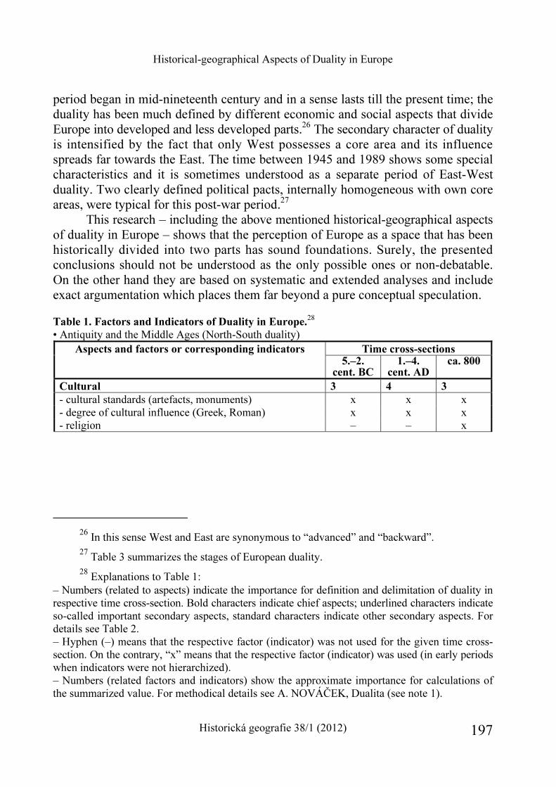
Historical-geographical Aspects of Duality in Europe
Historická geografie 38/1 (2012) 197
period began in mid-nineteenth century and in a sense lasts till the present time; the duality has been much defined by different economic and social aspects that divide Europe into developed and less developed parts.26 The secondary character of duality is intensified by the fact that only West possesses a core area and its influence spreads far towards the East. The time between 1945 and 1989 shows some special characteristics and it is sometimes understood as a separate period of East-West duality. Two clearly defined political pacts, internally homogeneous with own core areas, were typical for this post-war period.27
This research – including the above mentioned historical-geographical aspects of duality in Europe – shows that the perception of Europe as a space that has been historically divided into two parts has sound foundations. Surely, the presented conclusions should not be understood as the only possible ones or non-debatable. On the other hand they are based on systematic and extended analyses and include exact argumentation which places them far beyond a pure conceptual speculation.
Table 1. Factors and Indicators of Duality in Europe.
28 • Antiquity and the Middle Ages (North-South duality)
Aspects and factors or corresponding indicators Time cross-sections
5.–2. cent. BC
1.–4. cent. AD
ca. 800
Cultural 3 4 3
- cultural standards (artefacts, monuments) x x x - degree of cultural influence (Greek, Roman) x x x - religion – – x
26 In this sense West and East are synonymous to “advanced” and “backward”. 27 Table 3 summarizes the stages of European duality. 28 Explanations to Table 1:
– Numbers (related to aspects) indicate the importance for definition and delimitation of duality in respective time cross-section. Bold characters indicate chief aspects; underlined characters indicate so-called important secondary aspects, standard characters indicate other secondary aspects. For details see Table 2. – Hyphen (–) means that the respective factor (indicator) was not used for the given time cross-section. On the contrary, “x” means that the respective factor (indicator) was used (in early periods when indicators were not hierarchized). – Numbers (related factors and indicators) show the approximate importance for calculations of the summarized value. For methodical details see A. NOVÁČEK, Dualita (see note 1).
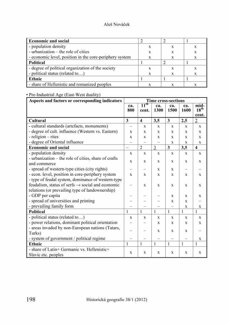
Aleš Nováček
Historická geografie 38/1 (2012) 198
Economic and social 2 2 1 - population density x x x - urbanization – the role of cities x x x - economic level, position in the core-periphery system x x x Political 1 2 1 - degree of political organization of the society x x x - political status (related to…) x x x Ethnic 1 1 1 - share of Hellenistic and romanized peoples x x x
• Pre-Industrial Age (East-West duality) Aspects and factors or corresponding indicators Time cross-sections
ca. 800
11th
cent.
ca. 1300
ca. 1500
ca. 1600
mid-18
th
cent.
Cultural 3 4 3,5 3 2,5 2 - cultural standards (artefacts, monuments) – x x x x x - degree of cult. influence (Western vs. Eastern) x x x x x x - religion – rites x x x x x x - degree of Oriental influence – – – x x x Economic and social – 2 3 3 3,5 4
- population density x x x x x x - urbanization – the role of cities, share of crafts and commerce
x x x x x x
- spread of western-type cities (city rights) – – x x – – - econ. level, position in core-periphery system x x x x x x - type of feudal system, dominance of western-type feudalism, status of serfs → social and economic relations (or prevailing type of landownership)
– x x x x x
- GDP per capita – – – x x x - spread of universities and printing – – – x x – - prevailing family form – – – – x x Political 1 1 1 1 1 1 - political status (related to…) x x x x x x - power relations, dominant political orientation – – x x x x - areas invaded by non-European nations (Tatars, Turks)
– – x x x –
- system of government / political regime – – – – – x Ethnic 1 1 1 1 1 1 - share of Latin+ Germanic vs. Hellenistic+ Slavic etc. peoples
x x x x x x
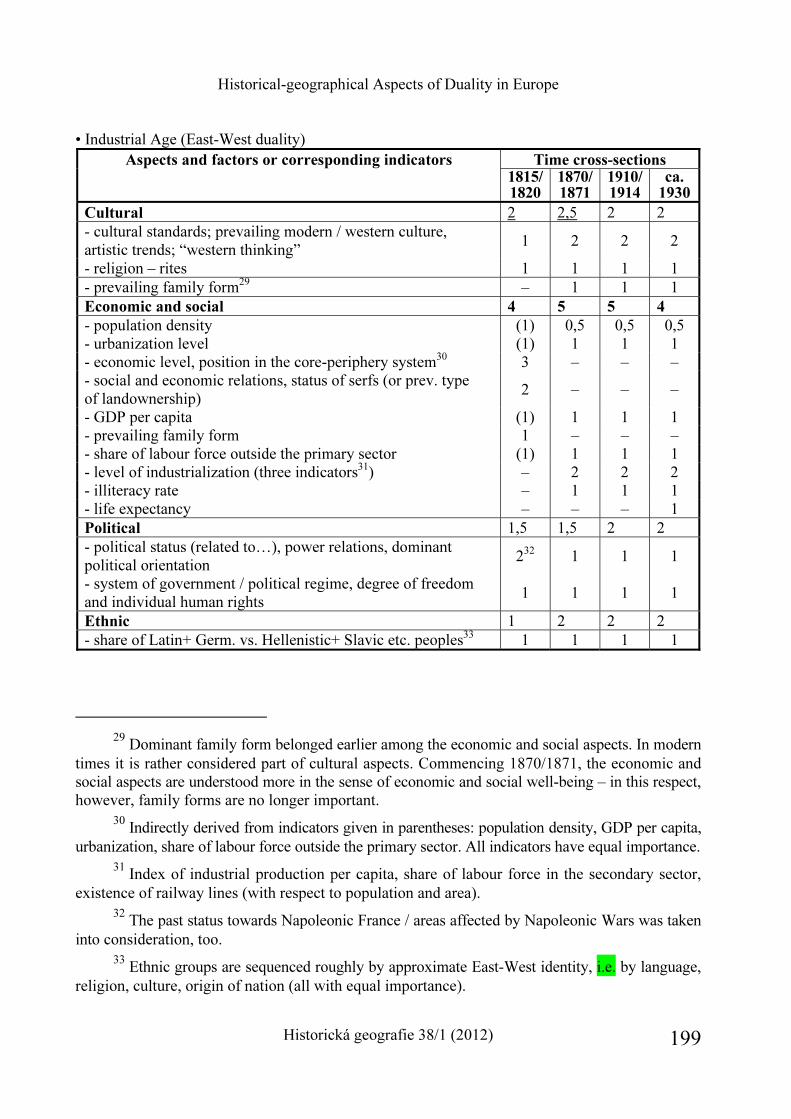
Historical-geographical Aspects of Duality in Europe
Historická geografie 38/1 (2012) 199
• Industrial Age (East-West duality) Aspects and factors or corresponding indicators Time cross-sections
1815/1820
1870/ 1871
1910/ 1914
ca. 1930
Cultural 2 2,5 2 2 - cultural standards; prevailing modern / western culture, artistic trends; “western thinking”
1 2 2 2
- religion – rites 1 1 1 1 - prevailing family form29 – 1 1 1 Economic and social 4 5 5 4
- population density (1) 0,5 0,5 0,5 - urbanization level (1) 1 1 1 - economic level, position in the core-periphery system30 3 – – – - social and economic relations, status of serfs (or prev. type of landownership)
2 – – –
- GDP per capita (1) 1 1 1 - prevailing family form 1 – – – - share of labour force outside the primary sector (1) 1 1 1 - level of industrialization (three indicators31) – 2 2 2 - illiteracy rate – 1 1 1 - life expectancy – – – 1 Political 1,5 1,5 2 2 - political status (related to…), power relations, dominant political orientation
232 1 1 1
- system of government / political regime, degree of freedom and individual human rights
1 1 1 1
Ethnic 1 2 2 2 - share of Latin+ Germ. vs. Hellenistic+ Slavic etc. peoples33 1 1 1 1
29 Dominant family form belonged earlier among the economic and social aspects. In modern
times it is rather considered part of cultural aspects. Commencing 1870/1871, the economic and social aspects are understood more in the sense of economic and social well-being – in this respect, however, family forms are no longer important.
30 Indirectly derived from indicators given in parentheses: population density, GDP per capita, urbanization, share of labour force outside the primary sector. All indicators have equal importance.
31 Index of industrial production per capita, share of labour force in the secondary sector, existence of railway lines (with respect to population and area).
32 The past status towards Napoleonic France / areas affected by Napoleonic Wars was taken into consideration, too.
33 Ethnic groups are sequenced roughly by approximate East-West identity, i.e. by language, religion, culture, origin of nation (all with equal importance).
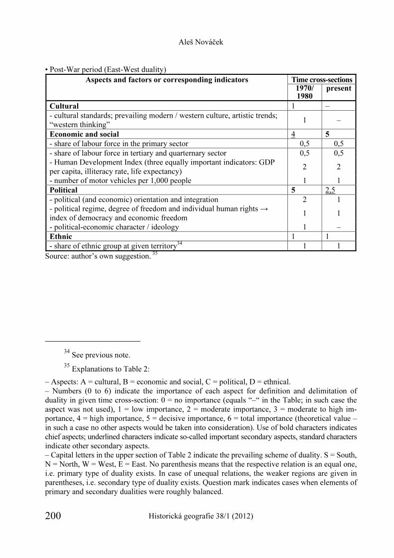
Aleš Nováček
Historická geografie 38/1 (2012) 200
• Post-War period (East-West duality) Aspects and factors or corresponding indicators Time cross-sections
1970/ 1980
present
Cultural 1 – - cultural standards; prevailing modern / western culture, artistic trends; “western thinking”
1 –
Economic and social 4 5
- share of labour force in the primary sector 0,5 0,5 - share of labour force in tertiary and quarternary sector 0,5 0,5 - Human Development Index (three equally important indicators: GDP per capita, illiteracy rate, life expectancy)
2 2
- number of motor vehicles per 1,000 people 1 1 Political 5 2,5 - political (and economic) orientation and integration 2 1 - political regime, degree of freedom and individual human rights → index of democracy and economic freedom
1 1
- political-economic character / ideology 1 – Ethnic 1 1 - share of ethnic group at given territory34 1 1
Source: author’s own suggestion. 35
34 See previous note. 35 Explanations to Table 2:
– Aspects: A = cultural, B = economic and social, C = political, D = ethnical. – Numbers (0 to 6) indicate the importance of each aspect for definition and delimitation of duality in given time cross-section: 0 = no importance (equals “–“ in the Table; in such case the aspect was not used), 1 = low importance, 2 = moderate importance, 3 = moderate to high im-portance, 4 = high importance, 5 = decisive importance, 6 = total importance (theoretical value – in such a case no other aspects would be taken into consideration). Use of bold characters indicates chief aspects; underlined characters indicate so-called important secondary aspects, standard characters indicate other secondary aspects. – Capital letters in the upper section of Table 2 indicate the prevailing scheme of duality. S = South, N = North, W = West, E = East. No parenthesis means that the respective relation is an equal one, i.e. primary type of duality exists. In case of unequal relations, the weaker regions are given in parentheses, i.e. secondary type of duality exists. Question mark indicates cases when elements of primary and secondary dualities were roughly balanced.
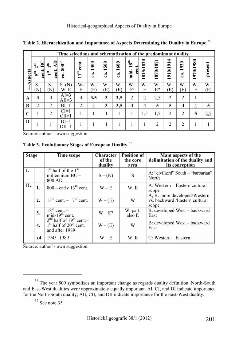
Historical-geographical Aspects of Duality in Europe
Historická geografie 38/1 (2012) 201
Table 2. Hierarchization and Importance of Aspects Determining the Duality in Europe.35
Time selections and schematization of the predominant duality
5th
–2
nd
cen
t. B
C
1st –
4th
cen
t. A
D
ca. 80036
11
th ce
nt.
ca. 1300
ca. 1500
ca. 1600
mid
- 18
th
cen
t.
1815/1
820
1870/1
871
1910/1
914
ca. 1930
1970/1
980
pre
sen
t
←A
spec
ts
S–(N)
S–(N)
S–(N) W–E
W-E
W–(E)
W–(E)
W–(E)
W–E?
W–E
W–E?
W–(E)
W–(E)
W–E
W–(E)
A 3 4 AI=3 AII=3
4 3,5 3 2,5 2 2 2,5 2 2 1 –
B 2 2 BI=1 2 3 3 3,5 4 4 5 5 4 4 5
C 1 2 CI=1 CII=1 1 1 1 1 1 1,5 1,5 2 2 5 2,5
D
1 1 DI=1
DII=1 1 1 1 1 1 1 2 2 2 1 1
Source: author’s own suggestion. Table 3. Evolutionary Stages of European Duality.
37
Stage Time scope Character of the
duality
Position of the core
area
Main aspects of the delimitation of the duality and
its conception
I.
1st half of the 1st millennium BC – 800 AD
S – (N) S A: “civilized” South – “barbarian” North
1. 800 – early 13th cent. W – E W, E A: Western – Eastern cultural scope
2. 13th cent. – 17th cent. W – (E) W A, B: more developed/Western vs. backward /Eastern cultural scope
3. 18th cent. – mid-19th cent. W – E? W, part.
also E B: developed West – backward East
4. 2nd half of 19th cent.– 1st half of 20th cent. and after 1989
W – (E) W B: developed West – backward East
II.
x4 1945–1989 W – E W, E C: Western – Eastern
Source: author’s own suggestion.
36 The year 800 symbolizes an important change as regards duality definition. North-South
and East-West dualities were approximately equally important. AI, CI, and DI indicate importance for the North-South duality; AII, CII, and DII indicate importance for the East-West duality.
37 See note 35.
Aleš Nováček
Historická geografie 38/1 (2012) 202
Historical-geographical Aspects of Duality in Europe
Historická geografie 38/1 (2012) 203
Aleš Nováček Historickogeografické aspekty duality Evropy Příspěvek předkládá osobitý pohled na prostorovou diferenciaci Evropy, přičemž vychází z hlavní hypotézy jejího trvalého a dějinného „rozdělení“ na dvě části. Takové pojetí Evropy se stalo zcela dominantním po 2. světové válce. Minimálně až do roku 1989 byla tato dualita odbornou literaturou i samotnou veřejností viděna jednoznačně: kapitalistický a demokra-tický Západ na jedné a socialistický a totalitární Východ na straně druhé. Ani po roce 1989 však nedošlo k rozpadu duálního vnímání Evropy. Kořeny duality sahají totiž daleko hlouběji do minulosti a lze ji kontinuálně pozorovat na širší škále jevů a aspektů. V jejich rámci je možné rozlišit čtyři historickogeografické aspekty duality: kulturní, ekonomicko-sociální, politický a etnický. Článek se jimi blíže zabývá z pohledu konkrétních faktorů a ukazatelů, které se nabízí k sledování a vymezování duality. Ta je zde chápána jako jev komplexní, dynamický a v minulosti proměnlivý. V průběhu dějin se proto váha uvedených čtyř aspektů při definování a vymezování duality měnila. To platí i pro působnost jednotli-vých faktorů a tím i vypovídací schopnost zvolených ukazatelů. Výsledný návrh jejich volby pro dané časové průřezy prezentují tabulky č. 1 a 2.
Závěr je věnován krátké syntéze tohoto vývoje, přičemž se zabývá obdobím od zformování duality kolem poloviny 1. tisíciletí př. n. l. až do současnosti. Rozlišuje dva typy duality. Tzv. primární typ, který označuje vztah dvou svébytných a relativně rovnocenných evropských regionů s vlastními jádry. A tzv. sekundární typ, který je cha-rakteristický nerovnocenným vztahem dvou oblastí, z nichž první představuje vyspělejší celek s vlastním jádrem a druhá zaostalejší nebo závislé území bez vlastního jádra. Dále se věnuje souborné periodizaci vývoje duality. Ten rozděluje do dvou fází, z nichž druhou ještě podrobněji člení na 4 až 5 etap (viz tabulka č. 3).
Příspěvek vychází z širšího autorova výzkumu, jehož hlavní výsledky byly nedávno publikovány v monografii nazvané „Dualita Evropy: historickogeografická analýza“.


REPORTS

HISTORICKÁ GEOGRAFIE 38/1 (2012)
http://www.hiu.cas.cz/cs/mapova-sbirka/historicka-geografie.ep/
207
The Landscape Atlas of the Czech Republic
Compiled map works have been a “visiting card” of the period of origin already for ages. They are as summary of topical information about the world or its parts (regions, states, and the like) as evidence of the level of scientific disciplines, representatives of which participate in creating of these map works (usually cartographers and geo-graphers in particular). On non-material level a series of them can be in a sense con-sidered art works.
The Czech geography and historical geography in contemporary atlas production continue in traditions from the Czechoslovak period, primarily from the 1960s (the Atlas of the Czechoslovak History from 1965, the Atlas of the CSSR from 1966) and the beginning of the 1990s (the Atlas of the Environment and Health of the Popula-tion of the CSFR). As opposed to Slovakia, where the Landscape Atlas of the Slovak Republic was released in 2002 and followed by the Population Atlas of Slovakia (2006), Czechia had to wait for an extensive atlas work till 2009.1 Until then Czechia missed current map work about landscape that could be used for purposes of long-term sustainable land use, landscape planning and assessment of man’s activities in the landscape. That is why the Ministry of the Environment of the Czech Republic announced the project of the “Landscape Atlas of the Czech Republic”, which goal was to process a map, graphical and pictorial document substantiating the current state of cognition of history and today’s state of the landscape and significant land-scape units or formations in the territory of Czechia in a visual way. Map and graphi-cal syntheses should be used as a strategic base for the requirements of sustainable long-term landscape use and landscape planning.
1 Atlas československých dějin [Atlas of the Czechoslovak History], ed. Jaroslav Purš,
Praha 1965; Atlas Československé socialistické republiky [Atlas of the Czechoslovak Socialist Republic], Praha 1966; Atlas životního prostředí a zdraví obyvatelstva ČSFR [Atlas of the Environ-ment and Health of the Population of the ČSFR], Brno 1992; László MIKLÓS et al., Atlas kra-jiny Slovenskej republiky [Landscape Atlas of the Slovak Republic], Bratislava 2002; Atlas oby-vateľstva Slovenska [Population Atlas of Slovakia], Bratislava 2006; Tatiana HRNČIAROVÁ – Peter MACKOVČIN – Ivan ZVARA et al., Atlas krajiny České republiky [Landscape Atlas of the Czech Republic], Průhonice 2009; Peter MACKOVČIN – Petr SLAVÍK, Atlas krajiny České re-publiky [Landscape Atlas of the Czech Republic], Geografické rozhledy 20, 2011, no. 2, pp. 6–7.
Reports
Historická geografie 38/1 (2012) 208
Three proposals submitted in reaction to the call of the Ministry of the Environ-ment of the Czech Republic were considered. The project supported by eight institu-tions with leadership of the Research Institute for Landscape and Dendrology in Průhonice was the winning one. Other participating institutions were Charles Uni-versity in Prague, Masaryk University in Brno, Palacký University in Olomouc, Institute of Geology AS CR and T. G. Masaryk State Hydrological Institute.
Basic goal of the Landscape Atlas elaboration was to provide as detailed picture as possible of the current state, past development and landscape prospects, its components and structures as for the whole territory of Czechia as for selected case areas. The landscape became one of the key themes not only in geographical research but also in a series of other disciplines in the past 25 years. Cartographic visualisation through GIS applications, based primarily on ArcGIS 9.x and ArcView GIS 3.x software products, was used for thematic content of individual layers and maps. The Slovak firm ESPRIT was the processor of the definitive cartographic form of the maps and pre-print configurations of the individual Atlas sections. The GIS Applications and the Landscape Ecology Departments of the Research Institute for Landscape and Dendrology in Průhonice (workplace in Brno) was deputed to edit the Atlas.
The structure of the Atlas has much in common with national atlases; neverthe-less it slightly differs from a usual concept, although the criteria for national atlases by the International Cartographic Union are roughly met. Above all it is the extent and extent particularity of a series of economic and social themes, for those that do not influence directly landscape structures, did not match with the atlas (economic relations in the territory, the structure of tertiary and quartiary activities and their spatial localisation, supplier-customer relations, etc.). Some themes suitable for na-tional atlas did not have the required data for relevant spatial structure (e.g. current data on labour or service commute, population move data). Contrary to a series of national atlases the Atlas comprises much higher number of very detailed maps and cartograms presenting territorial differentiation of many elements and components of the environment, while some introduce methodologically interesting originals not used so far (or differently processed) in similar works (e.g. subsection 4.1. Energy).
The total number of used map sources in this work reached the number of 906 originals and further 767 graphic elements. The Landscape Atlas has 332 pages in total and includes 1,137 numbered items. The Atlas is divided into 8 basic sections, which structure shows Table 1.
Section 1 entitled Landscape – the object of study, is thematically probably the most interesting section for historical geographers and historians, mainly then its subsection 1.2. Historical and Current Landscape Documents. In this subsection you can find map segments picturing the territory of Czechia in various periods of development (from Klaudyán Map of Bohemia from 1518 up to Digital Cadastre Map from 2009). In the second section entitled Geographical position the attention is paid
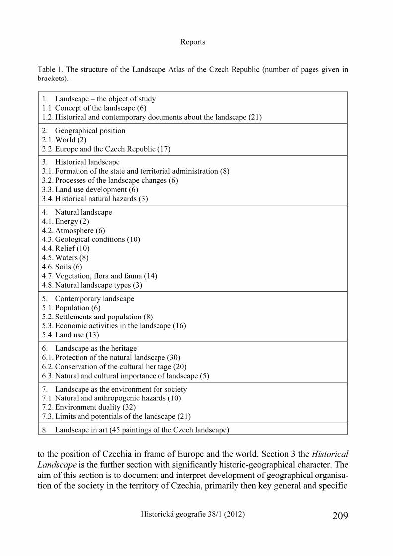
Reports
Historická geografie 38/1 (2012) 209
Table 1. The structure of the Landscape Atlas of the Czech Republic (number of pages given in brackets).
1. Landscape – the object of study 1.1. Concept of the landscape (6) 1.2. Historical and contemporary documents about the landscape (21)
2. Geographical position 2.1. World (2) 2.2. Europe and the Czech Republic (17)
3. Historical landscape 3.1. Formation of the state and territorial administration (8) 3.2. Processes of the landscape changes (6) 3.3. Land use development (6) 3.4. Historical natural hazards (3)
4. Natural landscape 4.1. Energy (2) 4.2. Atmosphere (6) 4.3. Geological conditions (10) 4.4. Relief (10) 4.5. Waters (8) 4.6. Soils (6) 4.7. Vegetation, flora and fauna (14) 4.8. Natural landscape types (3)
5. Contemporary landscape 5.1. Population (6) 5.2. Settlements and population (8) 5.3. Economic activities in the landscape (16) 5.4. Land use (13)
6. Landscape as the heritage 6.1. Protection of the natural landscape (30) 6.2. Conservation of the cultural heritage (20) 6.3. Natural and cultural importance of landscape (5)
7. Landscape as the environment for society 7.1. Natural and anthropogenic hazards (10) 7.2. Environment duality (32) 7.3. Limits and potentials of the landscape (21)
8. Landscape in art (45 paintings of the Czech landscape)
to the position of Czechia in frame of Europe and the world. Section 3 the Historical Landscape is the further section with significantly historic-geographical character. The aim of this section is to document and interpret development of geographical organisa-tion of the society in the territory of Czechia, primarily then key general and specific
Reports
Historická geografie 38/1 (2012) 210
Reports
Historická geografie 38/1 (2012) 211
Reports
Historická geografie 38/1 (2012) 212
processes that took part in changes of the environment, i.e. in forming and changes of the cultural landscape. The section as a whole not only describes and analyses changes in spatial distribution of phenomena and processes in time, but it performs also a contribution to the assessment of long-term development of geographical and environ-mental systems, to searching of factors behind and developmental mechanisms (societal and natural driving forces) of changes in society – nature and man – land-scape interactions in the Czech Lands from the Middle Ages to present.
The outcomes included in section 3 try to answer questions sort of: what was the reason of landscape changes or whether do causal relations among investigated phenomena and processes, that in the landscape, i.e. on various scale levels of regions, happened or happen, exist. At last but not least the section is thus a contribution to the research of determination of current problems of geographical or environmental systems that have their roots in the past. The section is divided into 4 thematically integral subsections (see Table 1). Thematic maps, graphic outcomes (photography, graphs) and annotations document development and changes as natural (physic-geo-graphical) conditions and risks in Czechia as social circumstances (socio-economic and socio-cultural conditions mainly of institutional, economic, political and cultural characters). Stress is laid primarily on presentation of the processes that contributed significantly to changes of the landscape and landscape character on various regional scales with prevailing assessments on state and local levels. Maps document e.g. general processes of concentration of population and social activities, industrialisa-tion, urbanisation, as well as the impact of specific developmental processes (e.g. impact of the post-war transfer of the Czech Germans, establishing of the Iron Curtain, insufficient resettlement of borderland).
Subsection Formation of the state and territorial administration documents as development of the state territory from the Early Middle Ages (the 9th century) to the origin of the Czech Republic in 1993, as changes of administration in the Czech territory from the first half of the 19th century up to present. The map collection enables to perceive the landscape changes in Czechia as in broader – prevailingly the Central European – context, as (in case of territorial administration) in context of administra-tion changes (state administration and self-government) and the affiliation of individual parts of the Czech territory to changing administrative units and their centres. The subsection comprises also the maps documenting the process of colonisation of the state territory, medieval and contemporary settlement abandonment, utilisation of modern GIS methods for reconstruction of old maps of the pre-industrial landscape, as well as examples of the historical landscape (baroque, romantic; the landscape of exploitation; the medieval and modern urban landscapes). The maps documenting changes of national structure of the population in Czechia in the course of the 20th century and the impact of changes of geopolitical position of Czechia in the second
Reports
Historická geografie 38/1 (2012) 213
half of the 20th century (case micro-regional study in the Czech-Austrian borderland) on the landscape structure and land use changes are the integral part of the subsection.
In subsection Processes of landscape changes we can find development of the landscape “loading” with economic activities of the society and changes of dominant functions of individual parts of the state territory. Primarily the maps of development of transport networks and series of maps of changes of territorial differentiation of employment in key economic sectors (industry, agriculture) among the years 1930, 1950, 1988 and 2001 are comprised in the subsection.
Subsection Land use development aims to document the landscape changes in the period from the Industrial Revolution to present, and that in key phases of our modern history: in the period from the half of the 19th century to the beginning of the communist regime in 1948, during the communist period (1945–1990) and in the first decade of the post-communistic transition of the Czech society and industry i.e. in the period of integration of Czechia into the European structures (1990–2000). Evaluation of the landscape changes as well as their interpretation is based on the research of Prague-Albertov LUCC School and is documented with cartograms as analytical as synthesising characters. Changes in the areas of fundamental macro-structures (e.g. agricultural land fund, forest areas) as well as of individual categories (e.g. changes of the area of arable land, permanent grassland, built-up and other areas) are presented here. Primarily typology of land use changes in individual periods of modern history as well as in the whole observed period can be considered innovative.
Examples of large-scale maps illustrating the land use, i.e. the landscape and landscape structure, changes on local level are included. Land use of a cadastre in the first half of the 19th century (based on the maps of “stable” cadastre) and at the turn of the 20th century (based on field mapping) are presented always in pairs. The set consists of eight case cadastres located in areas with various conditions as from physic-geographical as from socio-geographical (e.g. geo-economic, geo-historical, geo-political) points of view. The set of model areas documents not only changes in the landscape utilisation and its structure but also functional changes of areas in today’s core, semi-peripheral and peripheral areas (e.g. in the hinterland of Prague metropolitan area, in intensive agriculturally used areas, in borderlands).
Main part of subsection Historical natural hazards is a collection with inner interconnection of cartographic, graphic and text outcomes of the Brno school of his-torical climatology. It presents sources base for the research of climate changes in the territory of Czechia from the Middle Ages to present, the way of reconstruction of key data rows for evaluation of climate changes and also shows the examples of climatic and hydrological extremes.
Landscape as the Heritage (Section 6) consists of three subsections (see Table 1). It deals with significant parts of the landscape, natural resources and cultural values preserved from previous periods. The maps of natural and landscape conservation,
Reports
Historická geografie 38/1 (2012) 214
Reports
Historická geografie 38/1 (2012) 215
the maps of natural resources and monuments (especially protected areas, the Euro-pean localities of the Natura 2000, protected and non-protected sights) are integra-ted here.
The Landscape Atlas of the Czech Republic represents an extent and in many aspects original piece of work, in which creation participated more than three hundred of specialists from several tens of institutions. The Atlas presents not only extremely plentiful information base concerning state and development of the land-scape, its components and elements in Czechia but also reports rather well about the state and development of scientific research of the landscape at the turn of the 20th century. It represents an exceptional cultural act as well, for it provides this in-formation on high cartographical and aesthetic levels. And so the Atlas was perhaps worthily awarded as the best cartographic work at the ICA Congress in Paris in August 2010.
Ivan Bičík – Pavel Chromý – Vít Jančák
The Historical Town’s Atlas of the Czech Republic – as a part of the European project of historical atlases for comparative history of towns
The project “The Historical Town’s Atlas of the Czech Republic”, implemented by the The Institute of History, Academy of Sciences of the Czech Republic (http://www. hiu.cas.cz/cs/mapova-sbirka/historicky-atlas-mest-cr.ep/), was begun as a part of the European project of historical atlases for comparative history of towns, prepared under the auspices of the Commission internationale pour l’histoire des villes.
An important feature of the Historical Town’s Atlas of the Czech Republic is its trans-disciplinary character. The atlas summarizes and presents history of towns in their historical, urban, economic, regional, demographic, political and cultural context through reproductions of old maps and plans, reconstruction maps, iconographic ma-terial and text. It draws on the results of archaeology, history of settlement, historical geography, study of ecclesiastical dedications and other disciplines and approaches, using cartographic sources as well as reconstruction maps and digital cartography. By doing so, they open up new, non-traditional views on the life of medieval, early modern and modern towns and their development. The individual volumes of the atlas also support the development of regional and homeland research, connecting basic research with applied research. The project Historical Town’s Atlas of the Czech Republic has already received a number of important accolades: the prize of the Ministry of Education for 2004 (awarded on 8th November 2004) and the award of the Cartographic society of the Czech Republic in the category Atlases, collections and editions of maps, “Map of the year 2004” (awarded on 6th May 2005).
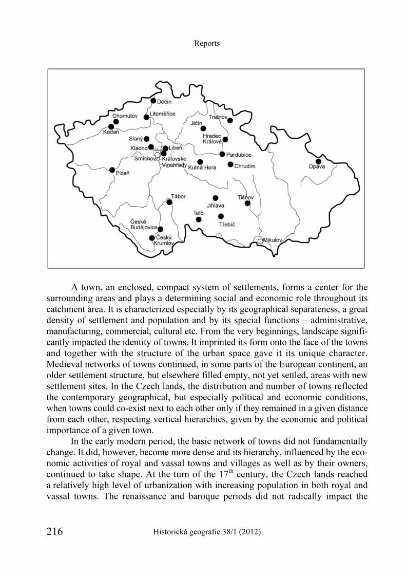
Reports
Historická geografie 38/1 (2012) 216
A town, an enclosed, compact system of settlements, forms a center for the surrounding areas and plays a determining social and economic role throughout its catchment area. It is characterized especially by its geographical separateness, a great density of settlement and population and by its special functions – administrative, manufacturing, commercial, cultural etc. From the very beginnings, landscape signifi-cantly impacted the identity of towns. It imprinted its form onto the face of the towns and together with the structure of the urban space gave it its unique character. Medieval networks of towns continued, in some parts of the European continent, an older settlement structure, but elsewhere filled empty, not yet settled, areas with new settlement sites. In the Czech lands, the distribution and number of towns reflected the contemporary geographical, but especially political and economic conditions, when towns could co-exist next to each other only if they remained in a given distance from each other, respecting vertical hierarchies, given by the economic and political importance of a given town.
In the early modern period, the basic network of towns did not fundamentally change. It did, however, become more dense and its hierarchy, influenced by the eco-nomic activities of royal and vassal towns and villages as well as by their owners, continued to take shape. At the turn of the 17th century, the Czech lands reached a relatively high level of urbanization with increasing population in both royal and vassal towns. The renaissance and baroque periods did not radically impact the
Reports
Historická geografie 38/1 (2012) 217
towns’ section plans, in the sense of dictating the demarcation of the urban space, but they influenced the transformations of internal urban spaces and shaped new dominants as well as ordinary street development. The wars of the 17th and 18th centuries also re-vitalized fortification activities.
The development of towns in the industrial period and the process of early modern urbanization, which has continued in several phases until the present day, established a vision of the world as a primarily urban civilization. In the 20th and the early 21st centuries, urban forms of settlement increased significantly across the whole world, the influx of population into towns continued and strengthened, towns developed and created extensive urbanized areas. Suburban areas with numerous agri-cultural estates and artisan and commercial centers gradually turned into industrial or administrative suburban areas. Urbanized landscape came to be interconnected via the railroad and new roads. Urbanization was characterized not only by a dense concentration of people in cities and by a rapid transformation of its social composi-tion and perceptions, but also by transformations of the internal space inside the towns, its most immediate surrounding areas and eventually of all of the settlement structures.
The world-wide trend points towards the rise of metropolises as extensive urban agglomerations with many millions of people. World cities are characterized by high density of population, large concentration of decision functions, high quality production bases, advanced services, financial markets and main crossroads of trans-port and information infrastructure. In internal zones of an urbanized agglomera-tion, a new kind of urban landscape arises, with extensive satellite settlements, and with separate zones for warehouses, industry and commerce. Urban greenery is re-constructed inside the revitalized city centers, many internal urban peripheries even-tually turn into commercial, residential or leisure complexes. Industrial heritage of the past is being mapped, a current trend which the Historical atlas underscores in its perception and reconstruction of the memory of the industrial urban landscape as an integral part of the overall transformation of the society, influenced at first primarily by the rise and development of industry, agriculture and transport, and eventually, especially in the latter half of the 20th century, globalizing trends in the society. The Czech lands have encountered this trend after 1800 and it continues into the present day in discrete phases that are chronologically, quantitatively and qualitatively demarcated.
The publication of the Historical Town’s Atlas of the Czech Republic is enormously important for the study of the process of urbanization in the Czech lands and of the history of urban settlements. It allows the application of comparative approaches in the context of domestic and European regions using a number of diverse variables, not only from the point of view of historical demography, as had been the case previously, but also in relation to the changes and mutual interactions
Reports
Historická geografie 38/1 (2012) 218
of urban settlements and landscape. Given its breadth, the project allows com-parative research on the process of urbanization in the Czech lands and in central Europe from the Middle Ages to the present day. It forms a collection of towns of different sizes, backgrounds and topography with rich histories and colorful fates of their inhabitants. Prague, and other towns (such as Kutná Hora) that have been placed on the list of protected sites by UNESCO have received special attention.
The research that precedes the preparation of each volume of the Historical
atlas allows for some of the traditional errors to be corrected and for known facts to be interpreted in new contexts – the symbiosis, competition and conflicts between towns and monasteries emerge as one of the current research topics, the same holds true for the relationship between towns and nobility (most recent research in selected localities suggest that noble holdings formed an appreciable portion in the majority of towns, which suggests a number of inevitable contacts in daily life); the question of visualization and representation through architecture and its expressive elements, studied intensively both in the Czech Republic and abroad, suggests that a similar spectrum of questions can be posed also in the case of our towns and representative buildings – whether financed by towns themselves or by ambitious individuals – which in turn offers an interpretative enrichment by new contexts. Re-searchers continue to look for other non-traditional approaches and new inspirations in the meaning of urban landscape on model case studies.
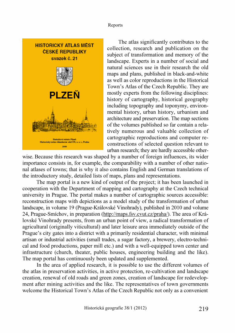
Reports
Historická geografie 38/1 (2012) 219
The atlas significantly contributes to the collection, research and publication on the subject of transformation and memory of the landscape. Experts in a number of social and natural sciences use in their research the old maps and plans, published in black-and-white as well as color reproductions in the Historical Town’s Atlas of the Czech Republic. They are mostly experts from the following disciplines: history of cartography, historical geography including topography and toponymy, environ-mental history, urban history, urbanism and architecture and preservation. The map sections of the volumes published so far contain a rela-tively numerous and valuable collection of cartographic reproductions and computer re-constructions of selected question relevant to urban research; they are hardly accessible other-
wise. Because this research was shaped by a number of foreign influences, its wider importance consists in, for example, the comparability with a number of other natio-nal atlases of towns; that is why it also contains English and German translations of the introductory study, detailed lists of maps, plans and representations.
The map portal is a new kind of output of the project; it has been launched in cooperation with the Department of mapping and cartography at the Czech technical university in Prague. The portal makes a number of cartographic sources accessible: reconstruction maps with depictions as a model study of the transformation of urban landscape, in volume 19 (Prague-Královské Vinohrady), published in 2010 and volume 24, Prague-Smíchov, in preparation (http://maps.fsv.cvut.cz/praha/). The area of Krá-lovské Vinohrady presents, from an urban point of view, a radical transformation of agricultural (originally viticultural) and later leisure area immediately outside of the Prague’s city gates into a district with a primarily residential character, with minimal artisan or industrial activities (small trades, a sugar factory, a brewery, electro-techni-cal and food productions, paper mill etc.) and with a well-equipped town center and infrastructure (church, theater, public houses, engineering building and the like). The map portal has continuously been updated and supplemented.
In the area of applied research, it is possible to use the different volumes of the atlas in preservation activities, in active protection, re-cultivation and landscape creation, renewal of old roads and green zones, creation of landscape for redevelop-ment after mining activities and the like. The representatives of town governments welcome the Historical Town’s Atlas of the Czech Republic not only as a convenient
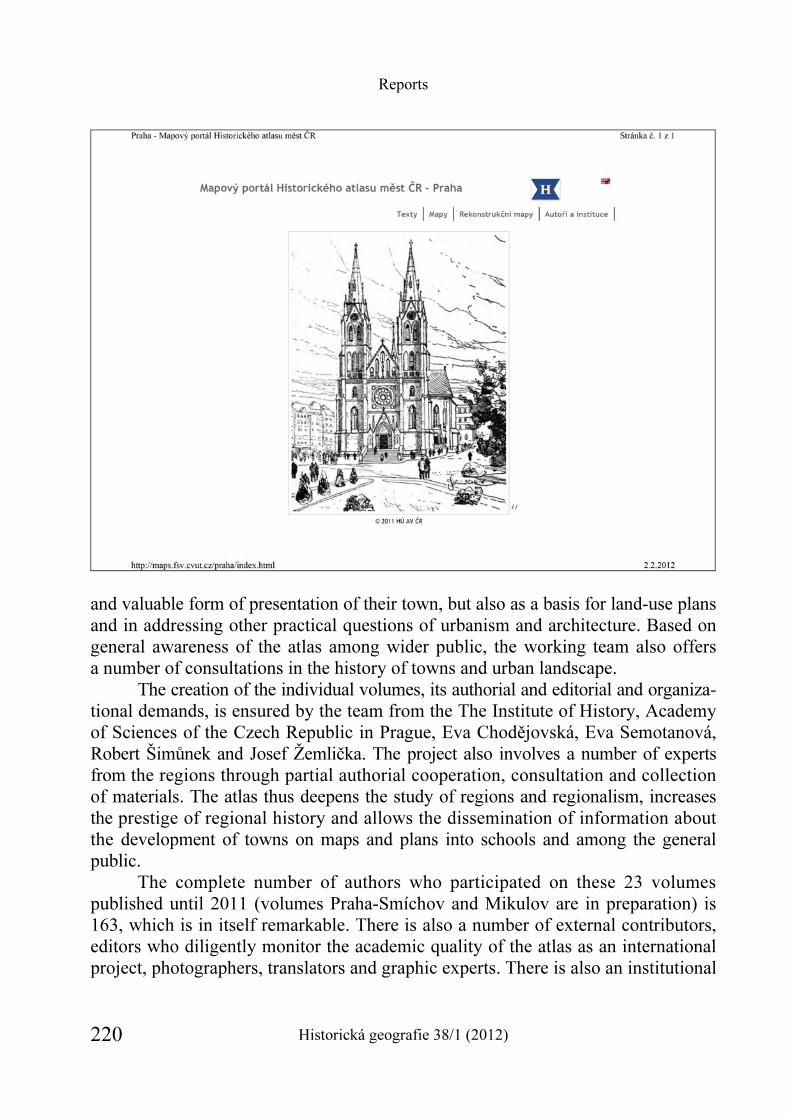
Reports
Historická geografie 38/1 (2012) 220
and valuable form of presentation of their town, but also as a basis for land-use plans and in addressing other practical questions of urbanism and architecture. Based on general awareness of the atlas among wider public, the working team also offers a number of consultations in the history of towns and urban landscape.
The creation of the individual volumes, its authorial and editorial and organiza-tional demands, is ensured by the team from the The Institute of History, Academy of Sciences of the Czech Republic in Prague, Eva Chodějovská, Eva Semotanová, Robert Šimůnek and Josef Žemlička. The project also involves a number of experts from the regions through partial authorial cooperation, consultation and collection of materials. The atlas thus deepens the study of regions and regionalism, increases the prestige of regional history and allows the dissemination of information about the development of towns on maps and plans into schools and among the general public.
The complete number of authors who participated on these 23 volumes published until 2011 (volumes Praha-Smíchov and Mikulov are in preparation) is 163, which is in itself remarkable. There is also a number of external contributors, editors who diligently monitor the academic quality of the atlas as an international project, photographers, translators and graphic experts. There is also an institutional
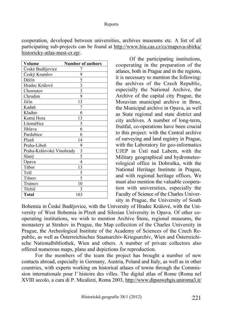
Reports
Historická geografie 38/1 (2012) 221
cooperation, developed between universities, archives museums etc. A list of all participating sub-projects can be found at http://www.hiu.cas.cz/cs/mapova-sbirka/ historicky-atlas-mest-cr.ep/.
Of the participating institutions, cooperating in the preparation of the atlases, both in Prague and in the regions, it is necessary to mention the following: the archives of the Czech Republic, especially the National Archive, the Archive of the capital city Prague, the Moravian municipal archive in Brno, the Municipal archive in Opava, as well as State regional and state district and city archives. A number of long-term, fruitful, co-operations have been crucial to this project: with the Central archive of surveying and land registry in Prague, with the Laboratory for geo-informatics UJEP in Ústí nad Labem, with the Military geographical and hydrometeo-rological office in Dobruška, with the National Heritage Institute in Prague, and with regional heritage offices. We must also mention the valuable coopera-tion with universities, especially the Faculty of Science of the Charles Univer-sity in Prague, the University of South
Bohemia in České Budějovice, with the University of Hradec Králové, with the Uni-versity of West Bohemia in Plzeň and Silesian University in Opava. Of other co-operating institutions, we wish to mention Archive Štenc, regional museums, the monastery at Strahov in Prague, the Map collection of the Charles University in Prague, the Archeological Institute of the Academy of Sciences of the Czech Re-public, as well as Österreichisches Staatsarchiv-Kriegsarchiv, Wien and Österreichi-sche Nationalbibliothek, Wien and others. A number of private collectors also offered numerous maps, plans and depictions for reproduction.
For the members of the team the project has brought a number of new contacts abroad, especially in Germany, Austria, Poland and Italy, as well as in other countries, with experts working on historical atlases of towns through the Commis-sion internationale pour l’ histoire des villes. The digital atlas of Rome (Roma nel XVIII secolo, a cura di P. Micalizzi, Roma 2003, http://www.dipsuwebgis.uniroma3.it/
Volume Number of authors
České Budějovice 7 Český Krumlov 9 Děčín 5 Hradec Králové 3 Chomutov 3 Chrudim 9 Jičín 13 Kadaň 7 Kladno 6 Kutná Hora 13 Litoměřice 5 Jihlava 6 Pardubice 6 Plzeň 14 Praha-Libeň 9 Praha-Královské Vinohrady 3 Slaný 5 Opava 4 Tábor 13 Telč 5 Tišnov 5 Trutnov 10 Třebíč 3 Total 163
Reports
Historická geografie 38/1 (2012) 222
gregoriano/), as one of the outputs of the project, led by prof. Paolo Micalizzi, proved to be a great inspiration. The project of the Historical Town’s Atlas of the Czech Republic is not only a work of historical geography, but also the result of application of trans-disciplinary approaches in historical work.
Eva Semotanová
Conferences in historical geography – traditional interdisciplinary meetings Since 2005, the Institute of History, Academy of Sciences of the Czech Republic in cooperation with the Department of social geography and regional development of the Faculty of Science of the Charles University in Prague organizes regular conferences on important topics in historical geography. Under the auspices of the Committee for historical geography, the conferences offer a meeting place for domestic and foreign academics in many related fields, with expertise pertaining to the relationship of man and nature and their mutual influence in the past and in the present. A number of contributions have been presented and discussed by historians, geographers, archeologists, archivists, architects and urbanists, cartographers, experts in geo-informatics or preservationists. The conference topics include not only theoreti-cal and methodological questions as well as source-based questions, but also results of on-going research in historical landscape of the Czech lands. Selected conference contributions have continuously been published in the journal Historická geografie [Historical geography] and in its supplements.
The first, inaugural, conference, entitled “Paths of historical geography – centers, trends, projects and perspectives”, took place on January 26th 2005 in the Institute of History, Academy of Sciences of the Czech Republic. Those present addressed the tradition of historical-geographical research in the Czech Republic as well as on-going theoretical and methodological questions in historical geography. They evaluated the state of contemporary research in historical geography in the Czech Republic and in Slovakia and addressed the most recent international trends and methodical approaches. They presented their own projects, exchanged informa-tion about new approaches and reflected on the contributions of their fields to the basic and applied research as well as to the preservation of the memory of the land-scape and to environmental education among the general public. Land-use was among the leading subjects, as was the Atlas of the landscape in the Czech Republic, the Historical Town’s Atlas of the Czech Republic and the Academic atlas of Czech history. There were also lectures that pertained to the source base of historical geo-graphy, addressing the collection of early modern forestry maps, the stability of the
Reports
Historická geografie 38/1 (2012) 223
land register in the 19th century, the written sources about the Jewish town of Třebíč etc. Considerable attention was devoted to contributions dealing with the teaching historical geography at universities (for example at University of South Bohemia in České Budějovice and at the University in Hradec Králové). Experts from the Czech Technical University in Prague, Faculty of Civil Engineering, presented applications of historical geography in urban practice, using two projects of reconstruction of a town and village space.
The first conference in 2005 started a tradition of meeting of those interested in historical geography; this was made evident in the second meeting in the series, entitled “Historical landscapes and cartographic riches in the Czech lands – sources, evidence, usage and accessibility”. The conference took place on January 25th 2006, again at the Institute of History, Academy of Sciences of the Czech Republic, and proved quite popular among academics. The first part of the meeting was devoted to old maps in the archives and map collections – their evidence and the question of making them accessible. Even though the cartographic material is the most basic and irreplaceable source of information for landscape research in the past, it is not at this point possible, unfortunately, to make use of it. In the majority of cases, the tools necessary for basic orientation in the material are lacking. Computer techno-logy allows not only a high-quality way of cataloguing the cartographic material, but it also allows for old maps to be made accessible via digitalization. An introduced digital map archive of the Czech geological service was not only well-functioning and well-executed, but also spoke about the inadequate digitalization of various map collections in the Czech republic. Those present agreed that making map collections accessible was sorely needed, as was the dissemination of information among academic public about cartographic materials in the Czech Republic. A map that has been digitalized makes the work of researchers easier in their basic study, but also protects the document itself. The second part of the conference consisted of a colorful mosaic of contributions, which analyzed the historical landscape on old maps using diverse methods and approaches.
The third meeting in the field of Historical geography, entitled “Society and landscape in the past, on reconstruction maps”, was devoted to the phenomenon of the reconstruction map and its research. The conference took place on January 24th 2007 in the Institute of History, Academy of Sciences of the Czech Republic. On that occasion, a number of historical maps and atlases from the map collection, themati-cally arranged, were put on display in the reading room of the Institute of History. The presenters devoted themselves to the questions of academic terminology and defined the terms used in contemporary historical geography (including the term “reconstruction map” itself). They briefly introduced the history of reconstruction maps and atlases in their relation to the history of cartography and offered an over-view of reconstruction maps, contained in the Historical Town’s Atlas of the Czech
Reports
Historická geografie 38/1 (2012) 224
Republic. The various sections of the atlas contain especially reconstruction maps of urban settlements, systems of town fortifications or development of administration. Because reconstruction maps are, in addition to atlases, scattered in many academic studies and publications as well, the conference attendees also disused the need for one catalogue of reconstruction maps. The catalogue should provided an annotated selective list of thematic historical maps, in accordance with the set criteria. Assembling such a catalogue would, however, be very time consuming. The presenters also introduced specific topics for historical-geographical research that would use re-construction maps.
The fourth conference in Historical geography, entitled “Regions – intersections of time and space?” took place on January 23rd 2008, in the villa Lanna, an academic conference center in Prague. The topic of the conference was region as a home (land, region, town and village and their surroundings), the paraphrase of a well-known postulate by a leading expert in environmental history of the USA, Donald Worster, served as the conference motto. Donald Worster, inspired by the conclusions of the conference of the United Nations on the environment in Stockholm in 1971 stated the following: “If each of us now has two countries to care about, we also have two histories to write, that of our own country and that of Planet Earth”.2 The motto of the conference “Regions – intersections of time and space?” flowed from this pronouncement: “If each of us now has three countries to care about, then we also have three histories to write, that of Planet Earth, that of our own country and that of our own region – regional history”. The attendees discussed the question which is now at the center of attention by domestic and foreign experts – regions, their creation, formation and transformation in the relationship to historical and con-temporary society and to landscape and regional identity. The focus was the creation, existence and disappearance of large and small territorial units in historical cir-cumstances, the relationship of man to his landscape, the place where he lives or lived, where man (society) defines and demarcates himself (itself). The discussions addressed questions such as the difficulty in demarcating regions in the past, their reconstruction and classification. The participants of the conference – historians, geographers, cartographers, architects, experts in geo-informatics, sociologists and many others attended a number of presentations on the regional problematic across the centuries; posters addressing the same questions were also on display. New topics came up in the course of discussions, topics which would instigate further research.
2 Donald WORSTER, The Vulnerable Earth: Toward a Planetary History, in: The Ends of the
Earth. Perspectives on Modern Environmental History, ed. Donald Worster, Cambridge – New York 1991, p. 6.
Reports
Historická geografie 38/1 (2012) 225
The fifth conference in Historical geography, entitled “The perception of landscape in the past – historical landscape in the present”, took place on January 21st 2009, again in the villa Lanna in Prague. The conference was dedicated to the transformations of historical landscape in the Czech Republic through the eyes of experts in various fields, using at times non-traditional methods and studying diverse spectrum of historical sources – written, pictorial, cartographic and material. The participants attended presentations on historical landscape in the medieval, early modern and modern periods, introduced with theoretical commentaries by a carto-grapher, an architect and an historian, all dealing with the question of geography and the transformation of landscape perceptions, of historical landscape and the institute of landscape character and reconstruction of the vanished and existing spaces via iGoogle. Individual studies followed, addressing questions of historical landscape of the Czech lands and in central European landscape in the medieval and early modern period (in the relationship to the baroque landscape as a phenomenon of the Czech lands), on the study of iconographic sources or sources of a personal nature (memories). An archeologist and a botanist from the institutes of the Aca-demy of Sciences of the Czech Republic offered an exemplary application of the interdisciplinary approach to the study of historical landscape, and did so in an engaging and non-traditional way. Ample discussion has become a full-fledged component of the conference proceedings, as it has continually presented opinions and methods of a number of natural and social sciences on the research in historical landscape. The thought of conference participant Martin Gojda from University of West Bohemia surfaced in a number of discussions: the Czech historical landscape is characterized by practicality, esthetics and spirituality.
The sixth conference in historical geography, entitled “Landscape of the town – town in the landscape”, took place on January 20th 2010; it was an interdiscipli-nary gathering of experts from historical, geographical and many other disciplines. The conference took place at the Faculty of Science of the Charles University in Prague. The participants celebrated the publication of the twentieth volume of the Historical Town’s Atlas of the Czech Republic. The contributions then analyzed the relationship between town and landscape, two seemingly contradictory phenomena, from different points of view. The town, a traditional settlement form of the central European region, whose origins on the territory of the Czech republic go back to the Middle Ages, to the early 13th century, can be understood as the result of human activities. Nevertheless, natural conditions influenced not only the origin of towns, tested its viability in the early years and determined its further development, but they have significantly influenced it to this day. The chronological spectrum of the contributions was quite wide – from the origins of town networks and specific studies of development in individual locations in the Middle Ages to urban conceptions in recent years. The meeting illustrated the breadth of usable sources as well as the
Reports
Historická geografie 38/1 (2012) 226
methodological pitfalls in their exploitation: cartographic and iconographic sources emerged as the basic kind of sources, but literary sources (for example travelogues) also seem to have a great evidentiary value. The importance of maps and plans for the study of development (and extinction) of settlement structures in (large) urban agglomerations was not neglected, and neither was the perspective of city planning. The conference once again confirmed the success of interdisciplinary discussions.
The seventh conference in historical geography, entitled “Industrial landscape as a cultural heritage”, took place on January 19th 2011 again at the Faculty of Science of the Charles University in Prague. Though the history of industry is a sub-ject that has been studied from different points of view for decades, here the parti-cipants addressed selected aspects of the study of industrial landscape, focusing especially on the impact of the industrializing processes in the 19th and 20th century on the contemporary landscape in the Czech Republic. The participants sought answers to the following questions: what is industrial landscape, what transformations has the Czech landscape undergone in the last century given the development and atte-nuation of industry in the traditional sense of the word and, especially, what traces have these processes left on contemporary landscape? The presenters introduced a number of examples of landscape, impacted and variously marked by the mining of raw materials, especially hard and brown coal, but also of landscape with agricultural industry and buildings of technical and economic nature (horse cars, artificial water-ways). In addition to lectures, the attendees viewed a collection of posters on the question of rise and transformation of industrial regions in the Czech Republic and the preservation of industrial complexes and buildings as a cultural heritage (industrial). The creation of databases of buildings with industrial past, whether protected or not, was at the center of attention as well.
The eighth, most recent, conference in historical geography, entitled “Land-scape and society in the geographical terminology”, took place on January 25th 2012, again at the Faculty of Science of the Charles University in Prague. The goal of the conference was to introduce local and place terminology as a research topic not only in historical geography but also in linguistics and in social sciences. The first module, entitled “Geographical terminology in dictionaries and databases”, introduced the basic projects involving record-making in relation to toponymy – the inter-national database GEONAMES and LUCC (Land Use and Land Cover Change), databases of place names in the Czech lands as well as a dictionary called the “Index of Czech Exonyms” (the related question of historical exonyms as sources for cultural history was discussed here as well). The module entitled “Geographical terminology as a historical source” focused on toponymes and their evidentiary value from the medieval to the modern periods – regional names and their connection to old paths, terminology of old maps, and, from the modern period, changes in the naming of public spaces and related toponymic creations of space in the Czech milieu in the
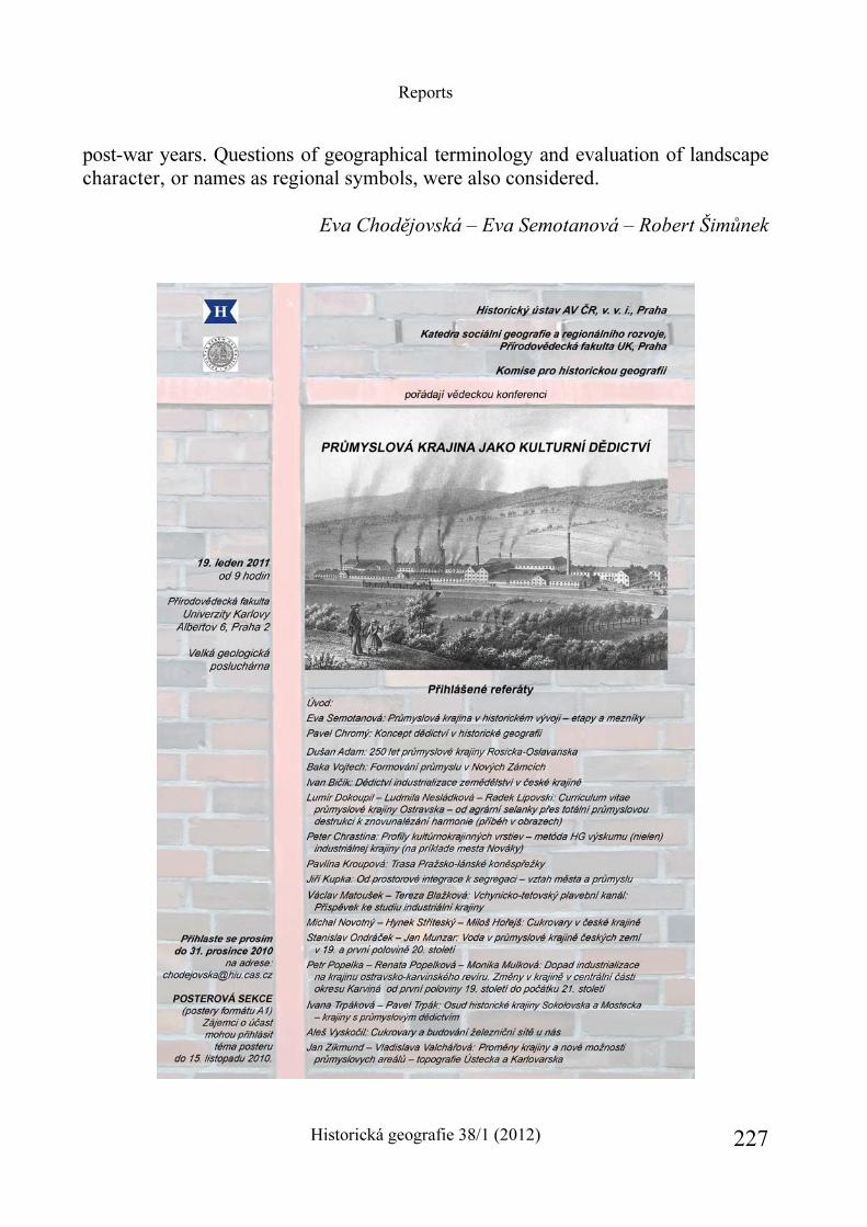
Reports
Historická geografie 38/1 (2012) 227
post-war years. Questions of geographical terminology and evaluation of landscape character, or names as regional symbols, were also considered.
Eva Chodějovská – Eva Semotanová – Robert Šimůnek

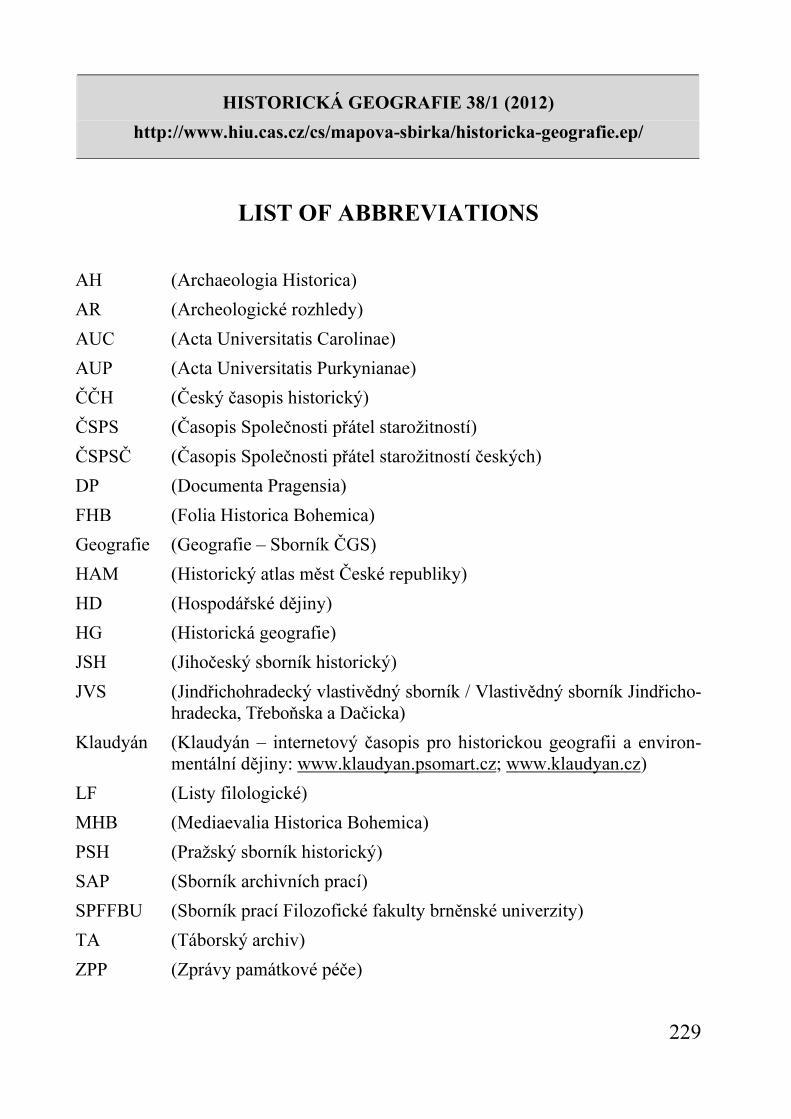
HISTORICKÁ GEOGRAFIE 38/1 (2012)
http://www.hiu.cas.cz/cs/mapova-sbirka/historicka-geografie.ep/
229
LIST OF ABBREVIATIONS AH (Archaeologia Historica)
AR (Archeologické rozhledy)
AUC (Acta Universitatis Carolinae)
AUP (Acta Universitatis Purkynianae)
ČČH (Český časopis historický)
ČSPS (Časopis Společnosti přátel starožitností)
ČSPSČ (Časopis Společnosti přátel starožitností českých)
DP (Documenta Pragensia)
FHB (Folia Historica Bohemica)
Geografie (Geografie – Sborník ČGS)
HAM (Historický atlas měst České republiky)
HD (Hospodářské dějiny)
HG (Historická geografie)
JSH (Jihočeský sborník historický)
JVS (Jindřichohradecký vlastivědný sborník / Vlastivědný sborník Jindřicho-hradecka, Třeboňska a Dačicka)
Klaudyán (Klaudyán – internetový časopis pro historickou geografii a environ-mentální dějiny: www.klaudyan.psomart.cz; www.klaudyan.cz)
LF (Listy filologické)
MHB (Mediaevalia Historica Bohemica)
PSH (Pražský sborník historický)
SAP (Sborník archivních prací)
SPFFBU (Sborník prací Filozofické fakulty brněnské univerzity)
TA (Táborský archiv)
ZPP (Zprávy památkové péče)

HISTORICKÁ GEOGRAFIE 38/1 (2012)
http://www.hiu.cas.cz/cs/mapova-sbirka/historicka-geografie.ep/
231
CONTENTS
Preface ..................................................................................................................... 5 ARTICLES Eva SEMOTANOVÁ – Pavel CHROMÝ Development and Current Trends of the Czech Historical Geography ................... 9 Vývoj a současné trendy v české historické geografii Robert ŠIMŮNEK The Landscape of the Czech Middle Ages in the Perspective of Modern Science .................................................................................................................... 35 Krajina českého středověku v pohledu moderní vědy Eva CHODĚJOVSKÁ Studying the Early Modern Landscape in the Czech Republic ............................ 63 Zkoumání krajiny raného novověku v České republice Markéta ŠANTRŮČKOVÁ The Principles and Development of Landscape Parks in the Czech Republic and Their Study from the Perspective of Historical Geography ............................ 99 Principy tvorby a vývoj krajinářských parků v České republice a jejich studium z hlediska historické geografie Aleš VYSKOČIL The Tale of the Landscape in the Czech Lands in the 19th Century .................... 119 Příběh krajiny 19. století v českých zemích Jiří KUPKA Urban Landscape in the Period of Industrialization ........................................... 143 Městská krajina v éře industrializace
Contents
Historická geografie 38/1 (2012) 232
Zdeněk KUČERA – Silvie KUČEROVÁ Historical Geography of Persistence, Destruction and Creation: The Case of Rural Landscape Transformations in Czechia’s Resettled Borderland ........... 165 Historická geografie přetrvávání, zkázy a obnovy: případ proměn venkov-ské krajiny dosídleného pohraničí Česka Aleš NOVÁČEK Historical-geographical Aspects of Duality in Europe ....................................... 185 Historickogeografické aspekty duality Evropy
REPORTS The Landscape Atlas of the Czech Republic ....................................................... 207 Ivan Bičík – Pavel Chromý – Vít Jančák The Historical Town’s Atlas of the Czech Republic – as a part of the European project of historical atlases for comparative history of towns ..............215 Eva Semotanová Conferences in historical geography – traditional interdisciplinary meetings ........222 Eva Chodějovská – Eva Semotanová – Robert Šimůnek
List of abbreviations .......................................................................................... 229
POKYNY PRO AUTORY
Otištěním svého příspěvku (studie, recenze, zprávy, diskusního příspěvku) v časopisu Historická geografie dává autor souhlas rovněž k jeho elektronické publikaci.
Metadata a texty budou zpřístupněny
a) na internetových stránkách projektu Digitální knihovny AV ČR (http://www. lib.cas.cz/cs/digitalni-knihovna-av-cr). Digitalizované plnotextové dokumenty, pod-léhající ochranné lhůtě autorského zákona, jsou dostupné pouze v Knihovně Akademie věd ČR
b) na internetové stránce Historického ústavu AV ČR v ikoně Nakladatelství ve formátu pdf, a to od ročníku 2012 vždy po uplynutí 1,5 roku od vydání příslušného čísla
c) recenze a anotace budou od ročníku 2012 zasílány v elektronické podobě na internetový portál recensio.net http://www.recensio.net/front-page
Žádáme autory, kteří v rámci svých studií počítají s obrazovými přílohami, aby redakci zaslali rovněž prohlášení o vlastnictví reprodukčních práv k jejich tištěné i elektronické publikaci. • Žádáme autory, aby dodržovali následující pravidla citačního úzu:
• Citace monografií podle vzoru: Adolf KUBEŠ, Dějepis města Třebíče, Třebíč 1874; v případě dvou a více autorů podle vzoru: Rudolf FIŠER – Libor TEPLÝ – Emanuel RANNÝ, Třebíč. Město a čas, Třebíč 1996. Titul a podtitul(y) je vhodné oddělovat tečkou.
• Citace časopiseckých článků podle vzoru: Pavel ŠTĚPÁN, K výskytu označení barev v místních a pomístních jménech v Čechách, Acta onomastica 43, 2002, s. 101–115.
• Citace článků ve sbornících podle vzoru: Jiří DVOŘÁK, K metodologii sociální historiografie v díle doc. dr. Milana Krýdla (1941–1991), in: Studie k sociálním dějinám 8, red. Jana Machačová – Jiří Matějček, Opava 2001, s. 92–100 (analogicky i v případě cizojazyčných sborníků – po názvu článku následuje „in:“, poté název sborníku, jeho editoři (hg./ed.), místo a rok vydání, a stránky citované studie).
• V souladu s běžným – a pro čtenáře užitečným – zvykem zahraničním byl pro opakované citace zaveden tento systém: první citace titulu v plném znění (např. Adolf KUBEŠ, Dějepis města Třebíče, Třebíč 1874), druhá a další zkráceně podle vzoru: A. KUBEŠ, Dějepis (jako pozn. ...) – tj. odkaz na poznámku s plnou citací.
• Periodika a sborníky s ustálenými zkratkami (např. ČČH, ČMM, ČSPS, HG, MHB, PHS, VVM ad.) je vhodné citovat těmito zkratkami; v případech, kdy
Contents
neexistuje ustálená a v odborné literatuře jednotně užívaná zkratka (např. HT i HusT pro Husitský Tábor, ad.), a přirozeně v případě časopisů méně známých (zvláště regionálních) je vhodné citovat titul časopisu/sborníku v plném znění (tj. včetně podtitulu). Analogicky i v případě cizojazyčné produkce.
• Žádáme současně autory, aby ke svému příspěvku připojili:
• Resumé (v rozsahu 1 normostrana) • Abstrakt (v rozsahu 5 – 8 řádků) • Klíčová slova (4 – 8)
• Studie nabídnuté k otištění v Historické geografii je možno zasílat na adresu redakce

Historická geografie 38/1. Výkonný redaktor Robert Šimůnek. – Praha: Historický ústav, 2012. – 232 s. (Historická geografie, ISSN 0323–0988). Technická redakce: Miroslava Paulová. Grafická úprava obrazových a mapových příloh: Blanka Šube-cová. Překlady textů: RNDr. Helena Janů, Miroslav Košek, Mgr. Nicholas Orsillo, Marcela K. Perett, PhD, RNDr. Vít Štěpánek. Hlavní distributor Kosmas.cz, Lublaňská 34, 120 00 Praha 2 (www.kosmas.cz). Jednotlivá čísla lze zakoupit rovněž v internetovém obchodě vydavatele: http:// obchod.hiu.cas.cz nebo v prodejnách Knihkupectví Academia (Václavské náměstí 34, Na Florenci 3, Národní 7, vše 110 00 Praha 1; www.academia.cz; www. academiabooks.com). Distribution rights in all remaining areas: Kubon and Sagner, Postfach 340108, D-80328 München, Germany, fax: 089/54218218. HG vychází dvakrát ročně / HG is published twice a year.
Articles appearing in this journal are abstracted and indexed in HISTORICAL AB-STRACTS, AMERICA: HISTORY AND LIFE and http://www.recensio.net/front-page


