All marine Automatic Identification System (AIS) units utilize a satellite based system such as the Global Positioning Satellite (GPS) network or the Global Navigation Satellite System (GLONASS) network to determine position. The accuracy of these networks is variable and is affected by factors such as the antenna positioning, how many satellites are used to determine a position and how long satellite information has been re-ceived for. It is desirable wherever possible therefore to verify both your vessels AIS derived position data and other vessels AIS derived position data with visual or radar based observations.
The easyTRX2 software is intended for use as an installation and confi-guration tool. The application is not a navigation tool and should not be used as such.
LICENSING
IMPORTANT: In most countries the operation of an AIS unit is included under the vessels marine VHF license provisions. The vessel on to which the AIS unit is to installed must therefore possess a current VHF radi-otelephone license which lists the AIS system and the vessel Call Sign and MMSI number. Please contact the relevant authority in your country for more information. In accordance with a policy of continual devel-opment and product improvement the easyTRX2 hardware and software may be upgraded from time to time and future versions of the easyTRX2 may therefore not correspond exactly with this manual. When necessary upgrades to the product will be accompanied by updates or addenda to this manual. Please take time to read this manual carefully and to un-derstand its contents fully so that you can install and operate your AIS system correctly.
Information contained in this manual is liable to change without notice. Weatherdock AG disclaims any liability for consequences arising from omissions or inaccuracies in this manual and any other documentation provided with this product.
Quick Instruction, Version 2.1 Page 3 of 40 pages
Weatherdock AG Sigmundstraße 180 90431 Nürnberg
Tel.:+49 911 37663835 www.weatherdock.de
DISCLAIMER
THIS SOFTWARE IS PROVIDED BY THE COPYRIGHT HOLDERS AND CON-TRIBUTORS "AS IS" AND ANY EXPRESS OR IMPLIED WARRANTIES, IN-CLUDING, BUT NOT LIMITED TO, THE IMPLIED WARRANTIES OF MER-CHANTABILITY AND FITNESS FOR A PARTICULAR PURPOSE ARE DIS-CLAIMED. IN NO EVENT SHALL THE COPYRIGHT OWNER OR CONTRIBU-TORS BE LIABLE FOR ANY DIRECT, INDIRECT, INCIDENTAL, SPECIAL, EX-EMPLARY, OR CONSEQUENTIAL DAMAGES (INCLUDING, BUT NOT LI-MITED TO, PROCUREMENT OF SUBSTITUTE GOODS OR SERVICES; LOSS OF USE, DATA, OR PROFITS; OR BUSINESS INTERRUPTION) HOWEVER CAUSED AND ON ANY THEORY OF LIABILITY, WHETHER IN CONTRACT, STRICT LIABILITY, OR TORT (INCLUDING NEGLIGENCE OR OTHERWISE) ARISING IN ANY WAY OUT OF THE USE OF THIS SOFTWARE, EVEN IF ADVISED OF THE POSSIBILITY OF SUCH DAMAGE.
WARNINGS AND PRECAUTIONS
IF YOU CHOOSE TO USE THE EASYTRX2 OR THE EASYSPLIT OR BOTH IN A
BOAT; IT IS THE SOLE RESPONSIBILITY OF THE OWNER/OPERATOR OF THE
EASYTRX2 (AND OR THE EASYSPLIT) TO SECURE THE BOAT SO THAT IT
WILL NOT CAUSE ANY DAMAGE OR PERSONAL INJURY IN THE EVENT OF
AN ACCIDENT.
SOME VESSELS DO NOT CARRY AIS.
IT IS IMPORTANT AT ALL TIME TO KEEP A PROPER LOOKOUT.
NEITHER THE “easyTRX2 (-IS)” NOR (AND OR) easySPLIT ARE NOT A SUBSTITUTE FOR GOOD SEAMANSHHIP.
This software uses components and source code developed by other companies or groups.
Copying of this document, and giving it to others and the use or com-munication of the contents thereof, is forbidden without express au-thority. Offenders are liable to the payment of damages.
Sin nuestra expresa autorización, queda terminantemente prohibida la reproducción total o parcial de este documento, así como su uso inde-bido y/o su exhibición o comunicación a terceros. De los infractores se exigirá el correspondiente resarcimiento de daños y perjuicios.
Pos Date New version
Author Description of change
1 19. Dec 2009
1.0 Kotouczek Base informa-tion
2 08. Feb 2011 2.0 Zimmermann Base informa-tion
3 07. March 2.2 Todua GPS Antenna
4
Quick Instruction, Version 2.1 Page 5 of 40 pages
Weatherdock AG Sigmundstraße 180 90431 Nürnberg
Tel.:+49 911 37663835 www.weatherdock.de
TABLE OF CONTENTS
PREREQUISITES 6
1. GENERAL INFORMATION TO AIS 7
1.1 What is AIS 7
1.2 What AIS classes do exist? 9
1.2.1 Class A 9
1.2.2 Class B 11
2. SCOPE OF DELIVERY 13
3. MOUNTING AND INSTALLATION 13
3.1 Programming Procedure 13
3.2 Diagnostics 15
3.3 AIS transmitting data 17
3.4 AIS receiving data 18
3.5 SD Card Recorder 19
3.6 CPA Alert 20
3.7 Mechanic and electric installation 22
3.7.1 Splitter Function 23
3.7.2 Mounting 26
3.7.3 VHF Antenna 27
3.7.4 GPS Antenna 27
3.7.5 Connection to a plotter 28
3.7.6 External switches/buttons 28
3.7.6.1 SRM button 28
3.7.6.2 Silent mode switch 28
3.7.7 External Devices (additional) 29
4. FOR USE OF THE EASYTRX2 (-IS) 29
Quick Instruction, Version 2.1 Page 6 of 40 pages
Weatherdock AG Sigmundstraße 180 90431 Nürnberg
Tel.:+49 911 37663835 www.weatherdock.de
4.1 Turn ON 29
4.2 LED Indication and functions 29
6. TROUBLESHOOTING 31
7. MAINTENANCE 31
8. STANDARDS 32
9. SPEC / TECHNICAL DATA 33
10. CONTACT AND SUPPORT INFORMATION 36
11. LICENSEE AGREEMENT 37
12. WARRANTY 37
13. INDEX 39
Congratulations!
Thanks to purchase a unit from the Weatherdock AG. This testifies your high technical competence, because you purchased the best available product on the market. Thank you.
PREREQUISITES
The easyTRX2 programming application is designed to operate with Microsoft Windows® 2000 (SP 3), XP (SP 2) and above. Recommended minimum system requirements are:
Microsoft Windows® 2000 SP3 or Microsoft Windows® XP SP2
Display resolution of at least 1024 x 768
One USB port
A pointing device (mouse or equivalent)
Quick Instruction, Version 2.1 Page 7 of 40 pages
Weatherdock AG Sigmundstraße 180 90431 Nürnberg
Tel.:+49 911 37663835 www.weatherdock.de
1. General Information to AIS
1.1 What is AIS
AIS stands for Automatic Identification System. AIS increases naviga-tional safety and collision avoidance by transmitting vessel identifica-tion, helping to reduce the difficulty of identifying ships when not in sight (e.g. at night, in radar blind arcs or shadows or at distance) by broadcasting navigational intentions to other vessels by providing ID, position, course, speed and other ship data with all other nearby ships and land based stations.
According to IALA regulations, AIS is defined as follows:
AIS is a broadcast Transponder system, operating in the VHF maritime mobile band. It is capable of sending ship information such as identifica-tion, position, course, speed and more, to other ships and to shore. It can handle multiple reports at rapid update rates and uses Carrier Sense Time Division Multiple Access (CSTDMA) technology to meet these high broadcast rates and ensure reliable and robust ship to ship operation.
The IMO defines the performance standards as follows:
Ship to ship working, ship to shore working, including long range appli-cation, automatic and continuous operation, provision of information messaging via PC and utilization of maritime VHF channels
The Modules:
GPS system, AIS Transponder, VHF Antenna, and the Data Power Cable and the appropriate application software.
AIS are required to function flawlessly in a variety of modes.
The relevant regulations requirements:
The system shall be capable of
An "autonomous and continuous" mode for operation in all areas. This mode shall be capable of being switched to/from one of the fol-lowing alternate modes by a competent authority;
Quick Instruction, Version 2.1 Page 8 of 40 pages
Weatherdock AG Sigmundstraße 180 90431 Nürnberg
Tel.:+49 911 37663835 www.weatherdock.de
An "assigned" mode for operation in an area subject to a compe-tent authority responsible for traffic monitoring such that the data transmission interval and/or time slots may be set remotely by that authority;
A "polling or controlled" mode, where the data transfer occurs in response to interrogation from a ship or competent authority.
This illustration depicts a typical AIS System, where two or more AIS equipped vessels (and shore based systems) are automatically communi-cating with each other.
The following sketch shows a typical easyTRX2 installation in a common environment. The easyTRX2 is connected to the vessels power supply, and in connection with the VHF, and GPS-Antennas, the minimal re-quirements for Transponder operation are fulfilled.
Both vessels in this illustration are equipped with an AIS transceiver.
Due to “Time – Synchronization” they use the same organization of free and allocated windows (Slots) in the shared VHF Data Link (this method is called “Carrier Sense Time Division Multiple Access”) to send and re-ceive messages. Without the necessity of any operating interaction, both
Quick Instruction, Version 2.1 Page 9 of 40 pages
Weatherdock AG Sigmundstraße 180 90431 Nürnberg
Tel.:+49 911 37663835 www.weatherdock.de
vessels know exactly who or what is cruising nearby and where the indi-vidual object is heading.
1.2 What AIS classes do exist?
The scenario below shows a full AIS coverage area (including all applica-tions and complete shore infrastructure).
There are two classes of AIS units fitted to vessels, Class A and Class B. In addition AIS base stations may be employed by the Coastguard, port authorities and other authorized bodies. AIS units acting as Aids to Navigation (A to N) can also be fitted to fixed and floating navigation markers such as channel markers and buoys.
1.2.1 Class A
Class A units are a mandatory fit under the safety of life at sea (SOLAS) convention to vessels above 300 gross tons or which carry more than 11 passengers in International waters. Many other commercial vessels and some leisure craft also may be fitted Class A units.
The Class A operation consists of three different types of messages:
Quick Instruction, Version 2.1 Page 10 of 40 pages
Weatherdock AG Sigmundstraße 180 90431 Nürnberg
Tel.:+49 911 37663835 www.weatherdock.de
Dynamic information:
MMSI number
position of the ship (derived from GPS)
time, when the position was measured in UTC
course over ground (COG)
speed over ground (SOG)
heading (HOG)
ship status
rotational speed/turn rate
Static information:
call sign and name of the vessel
length and width of the vessel
IMO-number of the vessel, if existent
type of vehicle
position of the GPS sensor onboard
Journey-related information:
draught of the vessel
type of cargo
port of destination and estimated time of arrival (ETA)
route plan, optional
The block of dynamic information is the most important block looking for threatening collisions. Therefore this block of information is trans-mitted in a compulsory way, depending on the vessels movement. The
Quick Instruction, Version 2.1 Page 11 of 40 pages
Weatherdock AG Sigmundstraße 180 90431 Nürnberg
Tel.:+49 911 37663835 www.weatherdock.de
following table shows the mandatory repetition rate of Class A transmis-sions linked to the ship’s movement:
anchored vessels 3 minutes
vessels at 0 – 14 kn 10 seconds
vessels at 0 – 14 kn, fast maneuver 3.3 seconds
vessels at 14 – 23 kn 6 seconds
vessels at 14 – 23 kn, fast maneuver 2 seconds
vessels at > 23kn 2 seconds
vessels at > 23 kn, fast maneuver 2 seconds
Static information as well as information belonging to the journey is dispersed every 6 minutes.
The reporting intervals correspond to both radio channels (161.975 MHz, 162.025 MHz) together.
1.2.2 Class B
Class B: EN62287, 2005: class B operation is described in the standard EN62287, published in 2005.This document is obligatory for class B. Pag-es 15 and 38 describe the operation:
Class B units are designed for fitting in vessels which do not fall into the mandatory Class A fit category.
The easyTRX2 (-IS) is a Class B AIS unit
Reporting intervals are:
dynamic ship data:
boats at < 2 kn: 3 minutes
Quick Instruction, Version 2.1 Page 12 of 40 pages
Weatherdock AG Sigmundstraße 180 90431 Nürnberg
Tel.:+49 911 37663835 www.weatherdock.de
boats at > 2 kn: 30 seconds
static ship data (similar to class A): 6 minutes
These intervals are the standard operation modes.
Competent authorities, like base stations, can have influence on the reporting intervals (as they do with class A as well). Interval timing can be reduced down to 5 seconds in exceptional cases. There is no automat-ism to change the 30sec/3min dynamic intervals by the ship itself.
Think about
The comparison is done only for dynamic data transmission, because these datasets contain the relevant information to calculate a future collision point in time and distance, as well as allow the threatened ships to communicate (MMSI number is stringent part of dynamic data infor-mation) by VHF. Additionally, 2 more facts concerning class B operation need to be mentioned:
Unlike the class A service, which is using the SOTDMA method (self or-ganized time division multiple access) with predefined timeslots (the ship listens to the traffic and the information containing in all other telegrams and defines its own raster of transmission timing, which is then distributed to all other participants within the radio range) the class B service is using a “listen-before-talk-method”. This means, that before transmitting, a ship has to observe the radio channel, whether to be allowed to transmit, if the channel is not occupied, or whether to wait for a free time slot.
To avoid disturbance of the professional class A service in crowded areas, higher-ranking authorities can switch off all class B transponder activities, which will probably never happen, but it should be men-tioned.
Above given information is not complete and should give only an over-view about the AIS topic. For more details please have a look to the following links:
US Coast Guard – http://www.navcen.uscg.gov/enav/ais/default.htm
Quick Instruction, Version 2.1 Page 13 of 40 pages
Weatherdock AG Sigmundstraße 180 90431 Nürnberg
Tel.:+49 911 37663835 www.weatherdock.de
IMO – www.imo.com
http://www.aislive.com
2. SCOPE OF DELIVERY
In the carton there is contained:
The easyTRX2 (-IS)
The cable for the easyTRX2 (-IS) incl. separate USB cable
This manual for the operation of the easyTRX2 (-IS)
The installation CD for the configuration software
3. MOUNTING AND INSTALLATION
3.1 Programming Procedure
Installation of the PC software for programming boat specific data
o Connection of the easyTRX2 (-IS) by means of the supplied ca-ble to the USB port of the PC
o THEN, connect the easyTRX2 (-IS) to the power, not before!
To use this program for configuring your easyTRX2 (-IS) , the “easyTRX2 Programming tool” must be installed to your PC.
Insert the installation CD.
When the installation does not start automatically, locate the file “setup.exe” on the CD-ROM drive and double click on this file to start the installation process.
Follow the screen prompts
Start the easyTRX2 (-IS) programming software to configure ship data (enter the MMSI carefully). It’s the only time you’ll need the programming software.
Quick Instruction, Version 2.1 Page 14 of 40 pages
Weatherdock AG Sigmundstraße 180 90431 Nürnberg
Tel.:+49 911 37663835 www.weatherdock.de
As vessel type you should select type 37 for a pleasure boat.
Enter the vessel’s information in the appropriate fields:
MMSI number: enter the vessel's Maritime Mobile Service Identity number (9 digits) This is an official number like a license plate at a car. Misuse will be punished very hard in different countries. Please be aware of that.
If the MMSI is not entered, the easyTRX2 won´t send any telegram. When connecting the easyTRX 2 for the first time, the MMSI is not defined (i.e. "000000000").
CAUTION:
For security reasons the MMSI of the vessel cannot be changed once it has been programmed. Do not program the MMSI unless you are certain you have the correct information. Please check the entered number carefully. If the programmed MMSI is incorrect the AIS trans-ponder will need to be returned to the supplier for factory reset.
Quick Instruction, Version 2.1 Page 15 of 40 pages
Weatherdock AG Sigmundstraße 180 90431 Nürnberg
Tel.:+49 911 37663835 www.weatherdock.de
Ship's name: enter the name of the vessel (20 characters maxi-mum)
Call Sign: enter the vessel's radio call sign (7 characters maximum)
Select the most appropriate vessel type from the drop-down list. For a pleasure craft (sailing and/or engine) it is 37.
Enter the vessel’s dimensions by defining the position of the GPS antenna (see the sketch above, all dimensions are in meter):
o Dimension A: distance from the GPS antenna location to the bow
o Dimension B: distance from the GPS antenna location to the stern
o Dimension C: distance from the GPS antenna location to the port side
o Dimension D: distance from the GPS antenna location to the starboard side
Select the appropriate baud rate for your PC or chart plotter de-vice (by default it is set to 38400 baud).
CAUTION:
If the easyTRX2 is set to 4800 Baud transfer rate, in high traffic areas it might be the possibility of missing some AIS position reports of other vessels.
The reason for that is the slower data throughput because of the data rate.
Weatherdock does not take any responsibility for a full and reliable re-ception of all AIS data around, if the RS422 baud rate is set to 4800 baud.
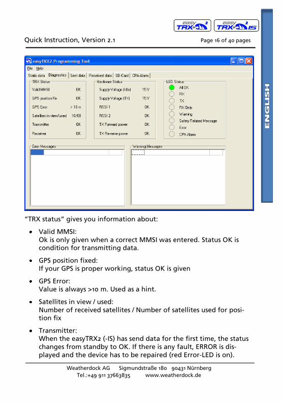
3.2 Diagnostics
If you select the tab “Diagnostics” you’ll get lot of information concern-ing the status quo of the easyTRX2 (-IS).
Quick Instruction, Version 2.1 Page 16 of 40 pages
Weatherdock AG Sigmundstraße 180 90431 Nürnberg
Tel.:+49 911 37663835 www.weatherdock.de
“TRX status” gives you information about:
Valid MMSI: Ok is only given when a correct MMSI was entered. Status OK is condition for transmitting data.
GPS position fixed: If your GPS is proper working, status OK is given
GPS Error: Value is always >10 m. Used as a hint.
Satellites in view / used: Number of received satellites / Number of satellites used for posi-tion fix
Transmitter: When the easyTRX2 (-IS) has send data for the first time, the status changes from standby to OK. If there is any fault, ERROR is dis-played and the device has to be repaired (red Error-LED is on).
Quick Instruction, Version 2.1 Page 17 of 40 pages
Weatherdock AG Sigmundstraße 180 90431 Nürnberg
Tel.:+49 911 37663835 www.weatherdock.de
Receiver: When the easyTRX2 (-IS) has received AIS data for the first time, the status changes from standby to OK. If there is any fault, ERROR is signaled and the device has to be repaired (Error-LED is on).
Hardware status displays the power situation of the device. Important is “Supply Voltage TX” which means the voltage level during transmission. Here the easyTRX2 (-IS) is drawing 2A. If cables are too thin and very long, the voltage may drop down below the “Idle-level”. If the drop down is more than 1V, you may use cables with larger copper diameter.
Value RSSI1 and RSSI2 give information, if there are any interferer on the AIS frequencies, which may be caused by a faulty electrical device. If there is none, the status will be OK.
TX Forward Power and TX Reverse Power are OK if the connected VHF antenna is proper working. If not, ERROR is displayed and the red LED is on.
If the self diagnostic of the easyTRX2 (-IS) noticed any fault, a sort notice will be given in the tables. The easyTRX2 (-IS) executes a self test every 30 sec. So each fault or warning report has got a countdown of 1 min. This means the report disappears from the table, when the fault is no longer valid after 1 min.
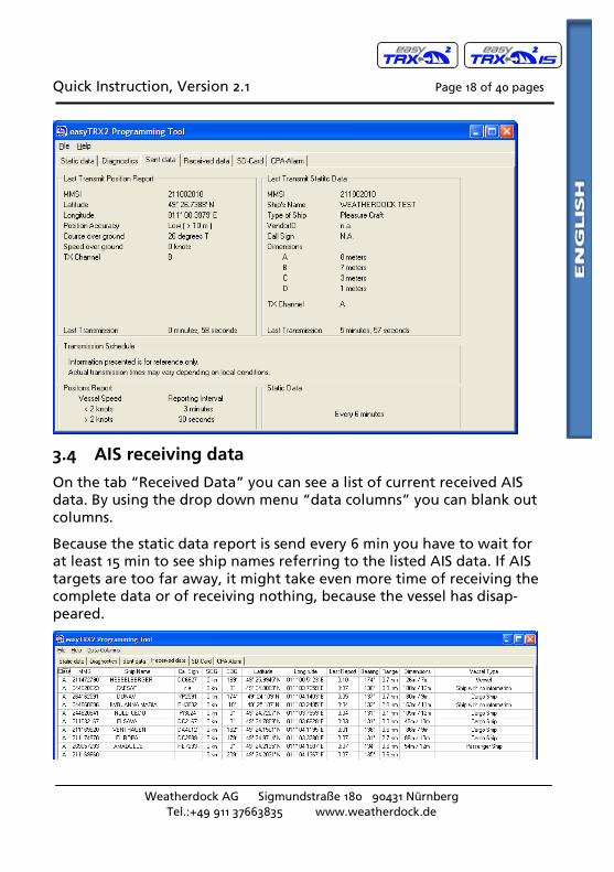
3.3 AIS transmitting data
The tab “Send Data” gives information about the latest send AIS data of the own vessel. There is on one hand the “position report” (AIS message No. 18), which transmits MMSI, position, speed and bearing. It is also shown how much time elapsed since latest transmission depending to your speed: 1min if speed is <2kn or 30 sec is speed is faster than 2 kn. On the other hand there is the “static data report” (AIS message No. 24) which includes MMSI, Ships name, call sign, ships dimensions and vessel type. This message will be send every 6 min.
Quick Instruction, Version 2.1 Page 18 of 40 pages
Weatherdock AG Sigmundstraße 180 90431 Nürnberg
Tel.:+49 911 37663835 www.weatherdock.de
3.4 AIS receiving data
On the tab “Received Data” you can see a list of current received AIS data. By using the drop down menu “data columns” you can blank out columns.
Because the static data report is send every 6 min you have to wait for at least 15 min to see ship names referring to the listed AIS data. If AIS targets are too far away, it might take even more time of receiving the complete data or of receiving nothing, because the vessel has disap-peared.
Quick Instruction, Version 2.1 Page 19 of 40 pages
Weatherdock AG Sigmundstraße 180 90431 Nürnberg
Tel.:+49 911 37663835 www.weatherdock.de
3.5 SD Card Recorder
The tab “SD Card” shows the status quo of the SD recording. “Ready for logging” is given if a well formatted SD Card is inserted.
The easyTRX2 (-IS) is using the FAT format. If the SD Card has got anoth-er format, you have to format it again with the easyTRX2 (-IS). It’s be-cause the device is storing a special set of files, which enable real time storing of AIS and GPS data.
If the status is “broken” or invalid format” you have to format the SD Card once again with the easyTRX2 (-IS). All stored data on it will be erased.
Being formatted with the easyTRX2 (-IS) you can remove the SD Card at any time without losing any data. In case of power loss the latest re-ceived data will be kept on the SD Card.
With your easyTRX2 you get the possibility of recording data to the SD-Card. All Data from the NMEA0183 and the USB will be recorded.
Quick Instruction, Version 2.1 Page 20 of 40 pages
Weatherdock AG Sigmundstraße 180 90431 Nürnberg
Tel.:+49 911 37663835 www.weatherdock.de
That means that all AIS-Messages (received and transmitted) together with the GPS-Information will be saved.
You can analyze this data with special software. So you can see your ship and all other vessels around.
Please use SD-Card with a capacity from 1 to 2 GB. Higher capacity is not supported. We recommend SD-Cards from "SanDisk " for best compatibility. (SD-Cards without SPI-Mode cannot be used with easyTRX2).
With a 2GB SD-Card you will be able to save 100 days of AIS-Data. ( e. g. Rotterdam, in areas with less traffic you can save more information.)
The only thing you have to do is insert the SD-Card into your TRX2. The device will start logging data automatically.
3.6 CPA Alert
“CPA Alert” tab gives the possibility to configure parameters, which trigger the alarm. CPA means “Closest Point of Approach” to a ship transmitting AIS data.
The easyTRX2 (-IS) has a built in feature which calculates the CPA with every received AIS target.
You’re able to set a safety radius around your ship. If a ship enters this radius within the given time limit, the CPA alarm occurs. You can change the parameters "CPA radius" and "CPA time limit" and configure the easyTRX2 by pressing the button “Program”. By pressing “Read” you can see the current settings. After power cycle these settings will remain.
The CPA alarm can be disabled and enabled by pressing the button "CPA-Alarm ON/OFF" and then "Program". When the button is high-lighted and shows the text "CPA-Alarm ON", then the CPA Alarm func-tion is active.
Caution:
Only vessels, which do have a proper working AIS aboard, are able to trigger the CPA alert. Please do not rely on this CPA alert without watching out for other vessels within your sight.
Quick Instruction, Version 2.1 Page 21 of 40 pages
Weatherdock AG Sigmundstraße 180 90431 Nürnberg
Tel.:+49 911 37663835 www.weatherdock.de
When a CPA-Alarm occurs, two actions are starting:
LED “CPA alert” is flashing for a few seconds
The cable with the marking "CPA" (white and brown wires) are getting the supply voltage (12V or 24V). So you can directly connect a buzzer for acoustic alarm.
This means you have got a standalone CPA alert even with disconnected plotter.
The CPA wires and CPA-LED will also indicate an alarm, when an AIS-SART signal is received. This function cannot be disabled by the user.
Quick Instruction, Version 2.1 Page 22 of 40 pages
Weatherdock AG Sigmundstraße 180 90431 Nürnberg
Tel.:+49 911 37663835 www.weatherdock.de
3.7 Mechanic and electric installation
The schematics of the mounting please take out of the following sketches:
Schematics for the easyTRX22 connection
GPS (BNC)
12 V DC
External switch (Function to be defined, no
contained in package
USB for PC
RS 422 NMEA(diffferential NMEA)
To Chartplotter
VHF Antenna
GPS Antenna
VHF Radio (SO 239)
CPA and RESCUE
Signal box
Quick Instruction, Version 2.1 Page 23 of 40 pages
Weatherdock AG Sigmundstraße 180 90431 Nürnberg
Tel.:+49 911 37663835 www.weatherdock.de
(VHF Radio only with "easyTRX2-IS" available!)
3.7.1 Splitter Function
The easyTRX2-IS has an integrated antenna splitter. By means of this splitter with built in RF signal amplifier, physical losses are eliminated. The splitter is checking whether there is transmit power from the VHF radio or the Class B AIS transceiver to the antenna. In case of this, the splitter disconnects very fast the other connected units (<1ms). In the standard reception mode the units are all connected to the same anten-na. A very fast disconnection is necessary because the easyTRX2-IS does transmit its signal with 2W power in a very short time. Therefore the used splitter has to disconnect the other units even faster than the de-vice starts transmitting its message.
Quick Instruction, Version 2.1 Page 24 of 40 pages
Weatherdock AG Sigmundstraße 180 90431 Nürnberg
Tel.:+49 911 37663835 www.weatherdock.de
Cable Colors: and Cable Order
The easyTRX2 is connected to the PC by means of an USB plug. The USB cable is enclosed in the box.
If you want to connect the easyTRX2 to a chart plotter please use the 6-pole cable, marked with NMEA. You need two cables. The white one has to be connected to the NMEA data input of the chart plotter, the green one to the NMEA ground of the input. For the cable connection sche-matics please look at following table:
Pos Cable group
Qu
an
tity
of
cab
les
Fin
al w
ire
colo
ur
Functionality
Pin
at
Su
b D
15
1 NMEA 6 Green NMEA out 38400, (-) 9
2 NMEA White NMEA out 38400, (+) 1
3 NMEA Pink NMEA in 38400, (-) 10
4 NMEA Grey NMEA in 38400, (+) 2
5 NMEA Brown NMEA in 4800, (-) 11
6 NMEA Yellow NMEA in 4800, (+) 3
7 External switches 4 Green SRM switch (-) 13
8 External switches White SRM switch (+) 5
9 External switches Brown Silent switch (-) 12
10 External switches Yellow Silent switch (+) 4
11 CPA & RESCUE ALARM 2 Brown CPA Alarm (-) 14
12 CPA & RESCUE ALARM White CPA Alarm (+) 6
13 Power 2 Black Power 9.6-31.2 VDC (-) ./.
14 Power Red Power 9.6-31.2 VDC (+) ./.
Quick Instruction, Version 2.1 Page 25 of 40 pages
Weatherdock AG Sigmundstraße 180 90431 Nürnberg
Tel.:+49 911 37663835 www.weatherdock.de
Quick Instruction, Version 2.1 Page 26 of 40 pages
Weatherdock AG Sigmundstraße 180 90431 Nürnberg
Tel.:+49 911 37663835 www.weatherdock.de
The brown and the yellow cable of the six pole cable do have a special function.
With that two cables further NMEA source data can be passed through to the easyTRX2 to the plotter or the PC.
The easyTRX2 has got an internal multiplexer who is able to upgrade incoming NMEA data of 4800 Baud transmission speed to 38400 Baud. These data are then passed through with the higher speed to the output.
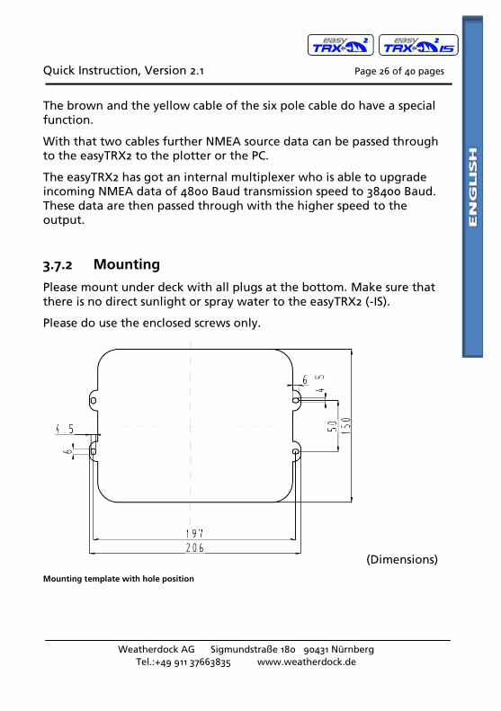
3.7.2 Mounting
Please mount under deck with all plugs at the bottom. Make sure that there is no direct sunlight or spray water to the easyTRX2 (-IS).
Please do use the enclosed screws only.
(Dimensions)
Mounting template with hole position
Quick Instruction, Version 2.1 Page 27 of 40 pages
Weatherdock AG Sigmundstraße 180 90431 Nürnberg
Tel.:+49 911 37663835 www.weatherdock.de
3.7.3 VHF Antenna
Your regular VHF antenna which you’re using for VHF radio will be connected to the easyTRX2 (-IS)
3.7.4 GPS Antenna
For the GPS antenna there is a TNC female bulkhead connector used, that mounts to the back of the case. This port provides the 5V DC feed for the active GPS antenna required by the easyTRX2 unit.
The GPS antenna used must be of the active type (i.e. it should incorpo-rate an LNA) and must be suitable for marine shipboard applications (index of protection, ruggedness, means of mounting, etc.). An antenna should be selected with a gain (in dB) depending on the length of cable between the antenna and the AIS unit; after subtraction of cable and connector losses a minimum total gain of 20 dB should be available at the easyTRX2 unit GPS antenna connector. The GPS antenna to be used for AIS use must be a dedicated antenna, i.e. not shared with any other GPS receiver. Installation of the GPS antenna is critical for the perfor-mance of the built in GPS receiver which is used for timing of the trans-mitted time slots and for the supply of navigational information should the main navigational GPS fail.
We strongly recommend that:
The GPS antenna is mounted in an elevated position and free of shadow effect from the ship’s superstructure.
The GPS antenna has a free view through 360 degrees with a vertical angle of 5 to 90 degrees above the horizon.
As the received GPS signal is very sensitive to noise and interference generated by other onboard transmitters, ensure that the GNSS antenna is placed as far away as possible from radar, Inmarsat and Iridium transmitters and ensure the GPS antenna is free from direct view of the radar and the Inmarsat beam.
It is also important that the MF/HF and other VHF transmitter antennas are kept as far away as possible from the GNSS antenna. It is good practice never to install a GNSS antenna within a radius of 2 meters from these antennas.
Quick Instruction, Version 2.1 Page 28 of 40 pages
Weatherdock AG Sigmundstraße 180 90431 Nürnberg
Tel.:+49 911 37663835 www.weatherdock.de
The easyTRX2 is approved with the GPS antenna from Weatherdock, article number: A029. The diameter of the antenna is 60mm, rest of the dimensions below
3.7.5 Connection to a plotter
The easyTRX2 is connected to the PC by means of a USB plug. The USB cable is enclosed in the box.
If you want to connect the easyTRX2 to a chart plotter please use the 6-pole cable, marked with NMEA. You need two cables. The white one has to be connected to the NMEA data input of the chart plotter, the green one to the NMEA ground of the input. For the cable connection schematics please look at above table (Pos.1 and Pos.2)
If the plotter interface is configured to 38400 baud and the plotter is ready for AIS data, received data will be shown immediately.
3.7.6 External switches/buttons
There is the possibility to connect external switches / buttons to the easyTRX2 (-IS).
3.7.6.1 SRM button
According to the cable colors under 3.7.1 (Pos.7 and Pos.8 in the spread-sheet) the green and the white cable of the 4 wires cable are foreseen for that functionality. If these 2 wires are connected to a BUTTON, not a SWITCH and if this button is pressed, then a SRM (Safety related mes-sage) is transmitted by the easyTRX2.
The sent default message is: “PAN PAN PAN”.
The message is sent and the SRM LED is blinking for one minute. After that you could send another SRM.
3.7.6.2 Silent mode switch
According to the cable colors under 3.7.1 (Pos. 9 and Pos. 10 in the spreadsheet) the brown and the yellow cable of the 4 wires cable are foreseen for that functionality. If these 2 wires are connected to a
Quick Instruction, Version 2.1 Page 29 of 40 pages
Weatherdock AG Sigmundstraße 180 90431 Nürnberg
Tel.:+49 911 37663835 www.weatherdock.de
SWITCH, not a BUTTON and if this switch is activated, then the easyTRX2 will not transmit any own position anymore. It will work in the pure reception mode, as long as the switch is activated.
3.7.7 External Devices (additional)
Referring to cable order under 3.7.1 (Pos.11 and Pos.12) it is possible to connect external devices with the brown and white cable, e.g. an exter-nal CPA Alarm signal source.
The easyCPA-Alarm is such an external signal source. If the easyTRX2 (-IS) forwards a CPA signal the CPA Alarm gives a loudly noise, even there is an AIS S.A.R.T. emergency message within range.
4. FOR USE OF THE EASYTRX2 (-IS)
4.1 Turn ON
After the easyTRX2 is connected according point 3.1 and the 12V supply is switched on, all eight visible LED on the top of the unit will illuminate once for a period of one second. Then each second LED in the row will be illuminated for one second and the other LED will be illuminated for one second.
4.2 LED Indication and functions
CPA Alarm: This LED will illuminate, if a ship is inside the defined and activated CPA Alarm radius (activated for default)
Error: This LED will be illuminated, if there is no GPS positions fix for 30 min, the supply voltage is low, the VSWR value is bad (means bad antenna cable or connection)
Safety message: This LED will be illuminated, if there was a safety message transmitted.
Warning: This LED will be illuminated, if easyTRX2 was not able to send own position, no valid GPS fix, not all static data are pro-grammed (e.g. MMSI)
RX only: This LED will be illuminated, if the external silent-switch
Quick Instruction, Version 2.1 Page 30 of 40 pages
Weatherdock AG Sigmundstraße 180 90431 Nürnberg
Tel.:+49 911 37663835 www.weatherdock.de
(wires green and white of the 4 wire cable) is connected. Then the easyTRX2 is in receive only mode.
AIS TX: This LED will be illuminated each time when the TRX2 is transmitting an AIS message
AIS RX: This LED will be illuminated each time when an AIS message is received.
Quick Instruction, Version 2.1 Page 31 of 40 pages
Weatherdock AG Sigmundstraße 180 90431 Nürnberg
Tel.:+49 911 37663835 www.weatherdock.de
6. TROUBLESHOOTING
Problem Cause Solution
Unable to con-nect to the easyTRX2 (-IS)
Incorrect con-nection data
Verify data COM-Port, etc. or USB port
Com port must be configured correct in the PC (Please see un-der configuration in the software manual)
Check connection
Not connected to network or cable
Check if your computer and the EasyTRX2 have connection to the network (IP-connection) or the same serial cable (serial connection)
Changes made to config form not accepted
Entries not valid
Correct the entries and transmit again
7. MAINTENANCE
Unauthorized opening of the easyTRX2 system will invalidate the war-ranty.
Avoid using chemical solvents to clean the easyTRX2 as some solvents can damage the case material. To clean, wipe down with a damp cloth.
The easyTRX2 contains no user serviceable parts.
Contact your Service Agent for repair or for replacing.
Quick Instruction, Version 2.1 Page 32 of 40 pages
Weatherdock AG Sigmundstraße 180 90431 Nürnberg
Tel.:+49 911 37663835 www.weatherdock.de
8. STANDARDS
This product complies with all the necessary standards under the European R&TTE directive for Article 3.1(a), 3.1(b), 3.2 and 3.3(e). The following standards have been followed in pursuance of this:
IEC62287-1: 2006-03 Maritime navigation and radio communication equipment and systems – Class B ship borne equipment of the automatic identification system (AIS) – Part 1: Carrier-sense time division multiple access (CSTDMA) techniques
IEC60945: 2002-08 Maritime navigation and radio communication equipment and systems – General requirements – Methods of testing and required test results
IEC61162-1: Maritime navigation and radio communication equipment and systems – Digital interfaces – Part 1: Single talker and multiple listeners
IEC61108-1: GLOBAL NAVIGATION SATELLITE SYSTEMS (GNSS) – Part 1: Global positioning system (GPS) -Receiver equipment - Performance standards, methods of testing and required test results
EN 301 843-1 v2.1: Electromagnetic compatibility and Radio spectrum Matters (ERM); Electromagnetic Compatibility (EMC) standard for marine radio equipment and services; Part 1: Common technical requirements
EN 50383: 2002 Basic standard for calculation and measurement of electromagnetic field strength and SAR related to human exposure from radio base stations and fixed terminal stations for wireless telecommunications system (110MHz – 40GHz)
EN60950-1:2006 Information technology equipment – Safety – Part 1: General requirements
Quick Instruction, Version 2.1 Page 33 of 40 pages
Quick Instruction, Version 2.1 Page 35 of 40 pages
Weatherdock AG Sigmundstraße 180 90431 Nürnberg
Tel.:+49 911 37663835 www.weatherdock.de
Parameter Value
Operator Controls
Optional pre-set safety related message (SRM) transmit button
or
Silent Mode -No Transmit switch.
Supported AIS -
Reporting Messages
for transmission only
Msg. 18:
The Class B position report is sent:
Every 30 seconds if SOG is > 2 kn;
Every 3 Minutes if SOG is < 2 kn
Provided that the transmission time periods are available. A command received by Message 23 shall override the reporting interval.
Msg.19:
The extended position report is sent only by request from an AIS base station.
Msg.24:
Static Data sub messages 24A / 24B will be transmitted every 6 minutes in addition to and independent of the position report. (MMSI, ship type, cargo type, call sign, ship dimensions).
Msg.14:
The safety related messages contain a short text, which is predefined: e.g. "PAN PAN". It is sent on manual activation only.
INFORMATION: It is not possible to initiate AIS messages by using the data interfaces. Therefore no AIS messages lasting longer than one time slot can be sent by the user interaction.
Quick Instruction, Version 2.1 Page 36 of 40 pages
Weatherdock AG Sigmundstraße 180 90431 Nürnberg
Tel.:+49 911 37663835 www.weatherdock.de
Parameter Value
AIS-Software version: 1.1.x
Compass safe distance to standard magnetic compass
0,80m
10. CONTACT AND SUPPORT INFORMATION
Although WEATHERDOCK strives for accuracy in all its publications; this material may contain errors or omissions, and is subject to change with-out prior notice. WEATHERDOCK shall not be made liable for any specif-ic, indirect, incidental or consequential damages as a result of its use. WEATHERDOCK components may only be used in safety of life devices or systems, with the express written approval of WEATHERDOCK, as the failure of such components could cause the failure of the WEATHER-DOCK device or system. If these fail, it is reasonable to assume that the safety of the user or other persons may be endangered.
Contact your local dealer for WEATHERDOCK AIS support.
Please see also our WEATHERDOCK Website: www.easyAIS.com
Quick Instruction, Version 2.1 Page 37 of 40 pages
Weatherdock AG Sigmundstraße 180 90431 Nürnberg
Tel.:+49 911 37663835 www.weatherdock.de
11. LICENSEE AGREEMENT
By using the easyTRX2 (-IS) you agree to be bound by the terms and conditions of the following warranty. PLEASE READ THIS AGREEMENT CAREFULLY.
Weatherdock grants you a limited license to use the software embedded in this device (the “Software”) in binary executable form in the normal operation of the product. Title, ownership rights, and intellectual prop-erty rights in and to the Software remain in Weatherdock AG. You ac-knowledge that the Software is the property of Weatherdock and is protected under the German copyright Laws and international copyright treaties. You further acknowledge that the structure, organization and code of the software are valuable trade secrets of Weatherdock and that the Software in source code remains a valuable trade secret of Weatherdock AG. You agree not to decompile, modify, reverse assem-ble, reverse engineer or reduce to human readable form the Software or any part thereof or create any derivate works based on the software. You agree not to export or re/export the software to any country.
12. WARRANTY
This Weatherdock product is warranted to be free from defects in mate-rials or workmanship for 24month from the date of purchase. Within this period, Weatherdock will at its sole option repair or replace any components that fail in normal use. Such repairs or replacement will be made at no charge to the customer for parts or labor, provided that the customer shall be responsible for any transportation cost. This warranty does not cover failures due to abuse, misuse, accident or unauthorized alteration or repairs.
THE WARRANTIES AND REMEDIES CONTAINED HEREIN ARE EXCLUSIVE AND IN LIEU OF ALL OTHER WARRANTIES EXPRESS OR IMPLIED OR STA-TUTORY, INCLUDING ANY LIABILITY ARISING UNDER ANY WARRANTY OF MERCHANTABILITY OR FITNESS FOR A PARTICULAR PURPOSE, STA-TUTORY OR OTHERWISE.
Quick Instruction, Version 2.1 Page 38 of 40 pages
Weatherdock AG Sigmundstraße 180 90431 Nürnberg
Tel.:+49 911 37663835 www.weatherdock.de
IN NO EVENT SHALL WEATHERDOCK BE LIABLE FOR ANY INCIDENTAL, SPECIAL, INDIRECT OR CONSEQUENTIAL DAMAGES, WHETHER RESULT-ING FROM THE USE, MISUSE, OR INABILITY TO USE THIS PRODUCT OR FROM DEFECTS IN THE PRODUCT.
Weatherdock retains the exclusive right to repair or replace the unit or software or offer a full refund of the purchase price at its sole discre-tion. Such remedy shall be your sole and exclusive remedy for any breach of warranty.
If you choose to use the EasyTRX2 and/or/or easySPLIT or both in a boat, it is the sole responsibility of the owner/operator of the EasyTRX2 to secure the easyTRX2 so that it will not cause damage or personal injury in the event of an accident. It is the sole responsibility of the operator of the boat to operate the boat in a safe manner, maintain full surveillance of all boating conditions at all times, and never become distracted by the EasyTRX2 to the exclusion of safe operating practices.
SOME VESSELS DO NOT CARRY AIS.
IT IS IMPORTANT AT ALL TIME TO KEEP A PROPER LOOKOUT.
THE “easyTRX2 (-IS)” ARE NOT A SUBSTITUTE FOR GOOD SEAMANSHIP
Quick Instruction, Version 2.1 Page 39 of 40 pages
Cable Colours · 24 Cable Order · 24 Call Sign · 15 CAUTION · 14, 15 Class A · 9 Class B · 9, 11, 32 COG · 10 Compass safe distance · 36 Connection to a plotter · 28 Contact · 36 CPA Alarm · 24, 29
D
default message · 28 designed to operate with · 6 Diagnostics · 15 Dimension A · 15 Dimension B · 15 Dimension C · 15 Dimension D · 15 dynamic information · 10


![CR AG 2020 - AAEEDELLYSaaeedellys.fr/textepdf/Var2020-02.pdf · 6h vrqw h[fxvpv 0du\ ± ± 'hopdwwr ± %delq ± ± 0dv ± ± 5rppr ± ± *dxglqr ± ± 5xl] ± ± &rpsdq ± ± 6ruldqr](https://static.dokumenty.site/doc/80x56/5fa1343e6dec5f0732122cd4/cr-ag-2020-6h-vrqw-hfxvpv-0du-hopdwwr-delq-0dv-5rppr.jpg)


