
#
KK
K
K
K
K
K
3
3
3
3
3
3
3
3
3
3
3
3
3
3
3
3
3
3
33
3
3
3
3
3
33
3
3
3
3
3
3
3
3
3
3
3
33
3
3
3
3
3
3
3
!!! !
!
!
!
!
!
!!
!!!
!
!
!
!!
!
!
!
!
!!!
!!
!
!
!
!
!!!
!
!
!
!
!!
!
!
! ! !
!
!
!!
!
!
!
!
!
!
!
!!
!
!
!
!
!!
!
!
!
!
!!
!
!
!!
!
!!
! !
!
!
!
!
!!
!
!
!
!
!
!
!
!
!
!
!
!!
!
!
!!!
!
!
!
!
!
!
!
!
!
!!
!
!
!
!
!!
!
!
!
!
!
!
!
!
!
!
!!
!
!
!
!!
!
!
!
!
!
!
!
!
!
!
!
!
!!
!
8
8
8
8
8
8
8
8
8
8
8
8
8
8
8
8
8
8
9
Health Center
Health Center
Bogak Health Center
Valencia Health Center
Maribohok Health Center
Lingig Rural Health Unit
Lingig Community Hospital
Lingig
KKK Elem. School
Zion Elem. School
Mahabo Elem. School
Bongan Elem. School
Taw-aga Elem. School
Sunrise Elem. School
Campo Primary School
Mahogany Elem. School
Hinipaan Elem. School
Tagbobo Primary School
Mahayahay Elem. School
Barcelona Elem. School
Tagpupuran Elem. SchoolNew Canaan Elem. School
Handamayan Elem. School
Union Elementary School
Tamsihan Primary School
Valencia Daycare Center
Lingig Nat'l High School
Salvacion Primary School
Guitamondok Elem. School
Hamindang Primary School
Mandus Elementary School
Bogak Elementary School
Mendezona Primary School
Haguimitan Primary School
Napanpanan Primary School
Sta. Maria Primary schoolSta. Maria Primary School
Rajah National High School
New Canaan Day Care Center
Barcelona Nat'l High School
Anibongan Integrated School
Tomas Sim Elementary School
Palo-alto Elementary School
Mansailao Elementary School
Pagtilaan Elementary school
San Roque Elementary school
Valencia Elementary School
Pinanapatan Elementary School
Proposed Elementary School Site
Rajah Cabungsuan Daycare Center
Antonio A. Oruzco Primary School
Pedro Redondo Elementary School
Rajah Cabungsuan Elementary School
Margarita K. Yusingco National High Scho
Surigao Sur Colleges (Laboratory High Sc
Union
Bogak
Bongan
Sabang
Mandus
Valencia
Salvacion
Poblacion
Mahayahay
Barcelona
Anibongan
Palo-Alto
Mansailao
Pagtilaan
San Roque
Tagpupuran
Handamayan
Rajah Cabungsuan
3
2 1
6
5
43
7
6
4
2
4
3 1
2 1
5
4
2
5
4
3
6
P2P1
P1
P4
P1
P3P2P1
P4
P3
P2P1
P3
P1
P4P3
P2P1
P7
P6P5
P4
P2
P7
P5
P4
P3P2P1
P4
P2
P1
P3 P2P1
P7
P6
P3
P5C
P5BP5A
P3C
P3A
P2C
P2AP1B
P4B
P5BP5AP4B
Obon
Kupot
Dumog
KayawanUgpason
Tagbobo
P7 Zion
Kayawan
Tamsihan
Bentigan
Bentigan
Tigbawan
Mahogany
P10 IpilP7 Campo
San Juan
Tigbawan
Bentigan
Tamsihan
Katipunan
P9 Hebron P2 Mahabo
P11 Tulay
Mahayahay
Malinawon
P5 Guwaan
P3 Nag-as
Mendezona
Sta. Maria
Napanpanan
San Isidro
P2 Taw-aga
P8 Road 51
P8 Sunrise
P6 Lokatan
P5 Bakulin
P5 Landing
Sta. Maria
Napanpanan
New Bayugan
P7A Maubgob
Pinanapatan
P3 Kauswagan
P6 Manganese
North Micaope
P6B Kasunugan
P6A Hinipaan
P6 New Canaan
P4 Pagbakatan
P13 Sto. Niño
P4 Taghonasan
P6 Haguimitan
North Micaope
P9 San Antonio
P5 New Paradise
P14 San Vicente
P12Bagong Silang
Maribojoc Island
Bongan Proposed Evacuation Center
0
Simulan Rive
r
Liboy Creek
Sum
u law
Riv
er
Bislig River
Lingig River
Taon River
Lind
a san
Cre
e k
Seg a
n Ri
ver
Tang
mar Riv
er
Mandug River
Lung
sad C
reek
Dacongbonwa River
Lumot Creek
Macar
oga R
iver
Sim
ulao
Ri ve
r
0
0
126°30'0"E
126°30'0"E
126°27'30"E
126°27'30"E
126°25'0"E
126°25'0"E
126°22'30"E
126°22'30"E
126°20'0"E
126°20'0"E
126°17'30"E
126°17'30"E
126°15'0"E
126°15'0"E
126°12'30"E
126°12'30"E
126°10'0"E
126°10'0"E8°
15'0
"N
8°15
'0"N
8°12
'30"
N
8°12
'30"
N
8°10
'0"N
8°10
'0"N
8°7'
30"N
8°7'
30"N
8°5'
0"N
8°5'
0"N
8°2'
30"N
8°2'
30"N
8°0'
0"N
8°0'
0"N
7°57
'30"
N
7°57
'30"
N
7°55
'0"N
7°55
'0"N
!
!
!
!!
!
!
!
!
!
!
!
!
!
!
!
!
!
!
Tago
Lingig
Bislig
Barobo
Lianga
Tandag
CortesLanuzaCarmen
Madrid
Tagbina
CagwaitBayabas
Hinatuan
Cantilan
Marihatag
Carrascal
San Miguel
San Agustin
Province of Surigao del Sur Index Map Caraga Region Index Map
O
Agusan del Norte
Agusan del Sur
Surigao del Sur
Surigao del Norte
Dinagat Province
GCS - Luzon 19111:50,000
0 650 1,300 1,950 2,600325Meters
Department of Environment and Natural Resources
MINES AND GEOSCIENCES BUREAUCaraga Regional Office No. XIII
Tel. No. (086) 826-5256http://www.mgbr13.ph [email protected]
MUNICIPALITY OF LINGIGProvince of Surigao del Sur
(10k Baseline Data)
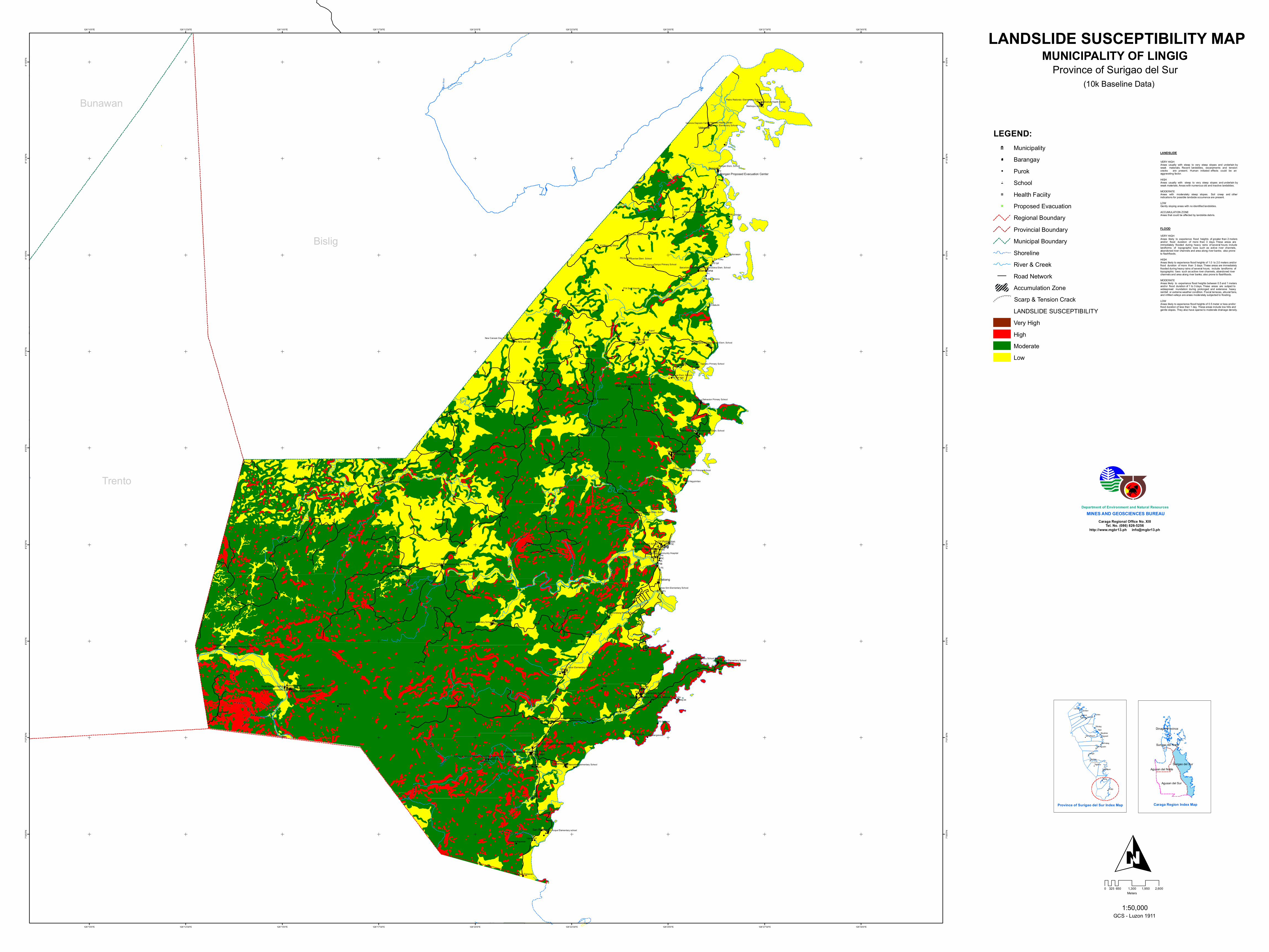
VERY HIGHAreas usually with steep to very steep slopes and underlain byweak materials. Recent landslides, escarpments and tensioncracks are present. Human initiated effects could be anaggravating factor.
HIGHAreas usually with steep to very steep slopes and underlain by weak materials. Areas with numerous old and inactive landslides.
MODERATEAreas with moderately steep slopes. Soil creep and otherindications for possible landside occurrence are present.
LOWGently sloping areas with no identified landslides.
ACCUMULATION ZONEAreas that could be affected by landslide debris.
VERY HIGHAreas likely to experience flood heights of greater than 2 meters and/or flood duration of more than 3 days. These areas areimmediately flooded during heavy rains of several hours; includelandforms of topographic lows such as active river channels,abandoned river channels and area along river banks; also proneto flashfloods. HIGHAreas likely to experience flood heights of 1.0 to 2.0 meters and/orflood duration of more than 3 days. These areas are immediatelyflooded during heavy rains of several hours; include landforms oftopographic lows such as active river channels, abandoned riverchannels and area along river banks; also prone to flashfloods.
MODERATEAreas likely to experience flood heights between 0.5 and 1 metersand/or flood duration of 1 to 3 days. These areas are subject towidespread inundation during prolonged and extensive heavyrainfall or extreme weather condition. Fluvial terraces, alluvial fans,and infilled valleys are areas moderately subjected to flooding.
LOWAreas likely to experience flood heights of 0.5 meter or less and/orflood duration of less than 1 day. These areas include low hills andgentle slopes. They also have sparse to moderate drainage density.
FLOOD
LANDSLIDE
LEGEND:9 Municipality
8 Barangay! Purok3 School
K Health Faciity
# Proposed Evacuation
Regional Boundary
Provincial Boundary
Municipal Boundary
Shoreline
River & Creek
Road Network
Accumulation Zone
Scarp & Tension Crack
LANDSLIDE SUSCEPTIBILITY
Very High
High
Moderate
Low
LANDSLIDE SUSCEPTIBILITY MAP
Trento
Bislig
Bunawan


![3 Ë/2+$ , 628+51 Ò'$- # 2 3 Ë35$9.8 · (psolflwl pj suiãhn sur nrqfhqwuiw sur lqix]qt ur]wrn (psolflwl pj suiãhn sur nrqfhqwuiw sur lqix]qt ur]wrn .9$/,7$7,91Ë $ .9$17,7$7,91Ë](https://static.dokumenty.site/doc/80x56/5e2cff2d01680d522e7c5090/3-2-62851-2-3-3598-psolflwl-pj-suihn-sur-nrqfhqwuiw-sur-lqixqt.jpg)


