ASSESSMENT OF AQUIFER SUSCEPTIBILITY DUE TO EXCESSIVE GROUNDWATER ABSTRACTION; A CASE STUDY OF YOGYAKARTA-SLEMAN GROUNDWATER BASIN Doni Prakasa Eka Putra 1 and I Gde Budi Indrawan 1 1 Department of Geological Engineering, Faculty of Engineering, Universitas Gadjah Mada, Yogyakarta, Indonesia e-mail: [email protected]Received Date: December 7, 2012 Abstract Yogyakarta-Sleman groundwater basin is one of productive groundwater basins in Indonesia. The groundwater basin is built by unconfined sand-aquifer system. Since the early 1980’s many schools, universities and hotels have been developed in this area to support education and tourism activities, and since the beginning of 2000’s the number of buildings has increased significantly. The development has resulted in a rapid rate of land use and population changes with the consequence of increasing groundwater pumping. Measurement results show that the rate of groundwater table degradation exceeds 0.5 m/year at some districts underlain by the groundwater basin. Because of this condition, it is necessary to assess the susceptibility of the aquifer to negative impacts due to the excessive groundwater pumping. The assessment was conducted by overlying factors such as aquifer response characteristics, aquifer storage characteristics, thickness of the aquifer, depth to groundwater table and distance from the sea. The assessment results show that the excessive groundwater abstraction to the aquifer has caused moderate to high susceptibility. It means that the groundwater pumping activities on this groundwater basin should be managed and controlled. Keywords: Aquifer susceptibility, Groundwater exploitation, Negative impacts of overexploitation, Yogyakarta-Sleman groundwater basin Introduction Yogyakarta-Sleman basin is located in the central-part of Java Island, and known as one of productive groundwater basins in Indonesia (Figure 1). In the last two decades, urbanization has transformed the area underlain by the groundwater basin. In 1930s, the population of this area was approximately only 60.000 [3], while nowadays it reaches almost 2,500,000. Since 1980s, the settlement pattern has shifted to many directions, defined by main road networks and service centres. New business, education, and tourism centres have grown with new settlements, made changes in the structure of the space organization, and increased pressure on water resources [11]. About less than 5% of the population in the Yogyakarta-Sleman groundwater basin is served by sewers system and less than 30% of urban population has access to clean water which is supplied by the local public water-work. Most of the population and activities depend on groundwater. As a result, the groundwater pumping increases, and impact of the groundwater exploitation is the groundwater table degradation which exceeds 0.3 m/year at some districts [10]). The groundwater abstraction on the groundwater basin is predicted to be up to 150 million m 3 /year in 2015 and 300 million m 3 /year in 2025 following the increase in number of population and economic development (tourism, commercial, industries, etc) [10]. Due to the increase in groundwater abstraction, the groundwater level in the study area is expected to continue to decline toward an ASEAN Engineering Journal Part C, Vol 3 No 2 (2014), ISSN 2286-8151 p.105
Transcript
ASSESSMENT OF AQUIFER SUSCEPTIBILITY DUE
TO EXCESSIVE GROUNDWATER ABSTRACTION;
A CASE STUDY OF YOGYAKARTA-SLEMAN
GROUNDWATER BASIN
Doni Prakasa Eka Putra1 and I Gde Budi Indrawan
1
1 Department of Geological Engineering, Faculty of Engineering,
Universitas Gadjah Mada, Yogyakarta, Indonesia e-mail: [email protected]
Received Date: December 7, 2012
Abstract
Yogyakarta-Sleman groundwater basin is one of productive groundwater basins in Indonesia. The
groundwater basin is built by unconfined sand-aquifer system. Since the early 1980’s many schools,
universities and hotels have been developed in this area to support education and tourism activities,
and since the beginning of 2000’s the number of buildings has increased significantly. The
development has resulted in a rapid rate of land use and population changes with the consequence of
increasing groundwater pumping. Measurement results show that the rate of groundwater table
degradation exceeds 0.5 m/year at some districts underlain by the groundwater basin. Because of this
condition, it is necessary to assess the susceptibility of the aquifer to negative impacts due to the
excessive groundwater pumping. The assessment was conducted by overlying factors such as aquifer
response characteristics, aquifer storage characteristics, thickness of the aquifer, depth to groundwater
table and distance from the sea. The assessment results show that the excessive groundwater
abstraction to the aquifer has caused moderate to high susceptibility. It means that the groundwater
pumping activities on this groundwater basin should be managed and controlled.
“unacceptable” situation indicated by severe negative environmental impacts, such as
reduction of river flows and missing of spring flows.
The concept of aquifer susceptibility from the negative impacts of excessive groundwater
abstraction were introduced by Foster [6] and also proposed by Adams & MacDonald [1].
The concept of susceptibility from negative impact of groundwater over exploitation is
developed in the same manner, and be as useful as that of vulnerability to pollution.
The term of susceptibility is used to avoid confusion with the term vulnerability which is
generally related to the susceptibility of aquifer from contamination [1]. If the potential
impacts of excessive exploitation can be identified before they occur, or at least before
they become significant, management measures can be taken to avoid or mitigate undesirable
effects [1].
This paper presents an assessment of aquifer susceptibility due to groundwater
overexploitation in Yogyakarta-Sleman. The method is essentially a modified method
initially proposed by Foster [6] with some modifications. The assessment will be useful
to define the management strategies on this groundwater basin [1], mainly by provides a tool
to planners responsible for regional development to enable them to assess the long term
inter-relationship between development (spatial land use planning) and their effects to the
regional groundwater resources.
Literature Review
Hydrogeology of the Study Area
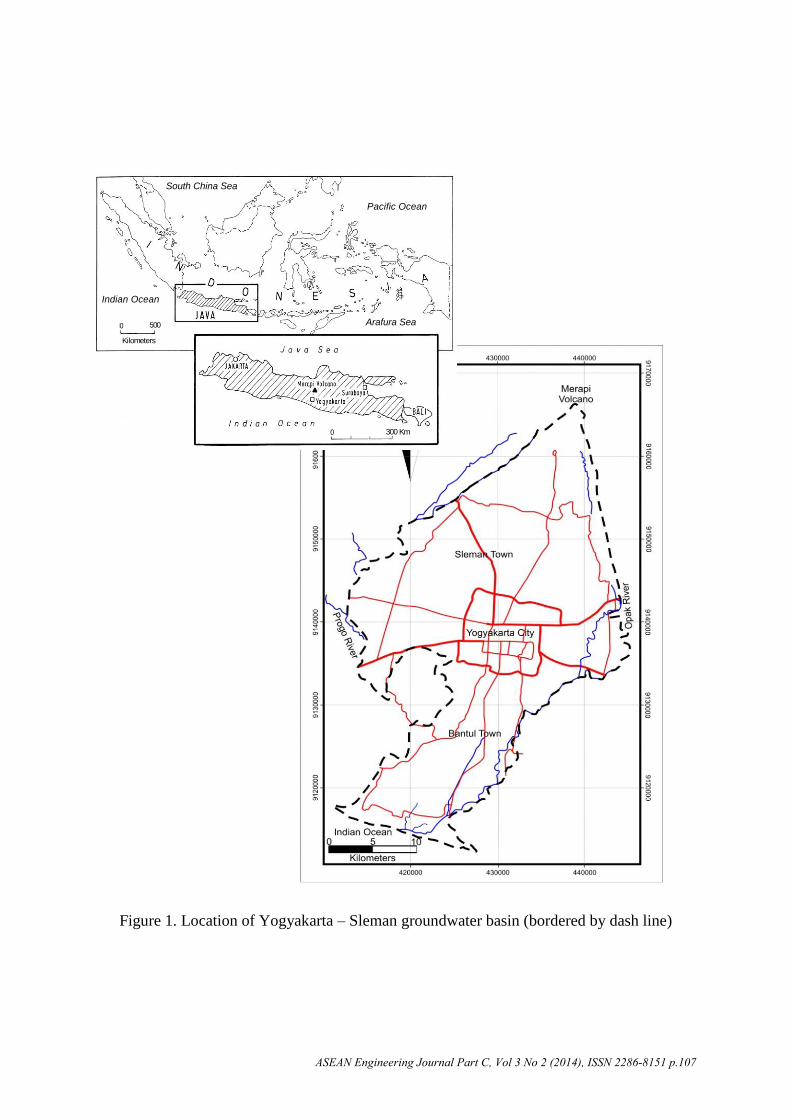
The groundwater basin is located at the south of Merapi volcano slope, bordered by two main rivers in
the east and west (Opak river and Progo river, respectively), and ended in the south by Indian Ocean
[5,8]. Morphologically, the groundwater basin is also bordered by Kulonprogo and
Baturagung hills (Figure 1). Geologically, the groundwater basin is bordered by two main
faults, i.e., a fault along Opak river at east side and a fault along Progo river at west side. In
addition, normal faults in the groundwater basin formed Bantul and Yogyakarta grabens
[5,8]. The groundwater basin consists of Yogyakarta Formation underlain by Sleman
Formation. Both rock formations are volcanic materials of Merapi Volcano and very potential
aquifer layers [8].
The aquifer in the groundwater basin can be classfied into two main aquifers: upper and
lower aquifers [8] (see Figure 2). Both aquifers are composed of an inter-bedded middle to
coarse sands, gravels, silts, clays and lenses of breccia. In the upper aquifer, sand and gravels
are to be more prevalent in the top 10 to 25 m [8]. The lower aquifer consists of generally
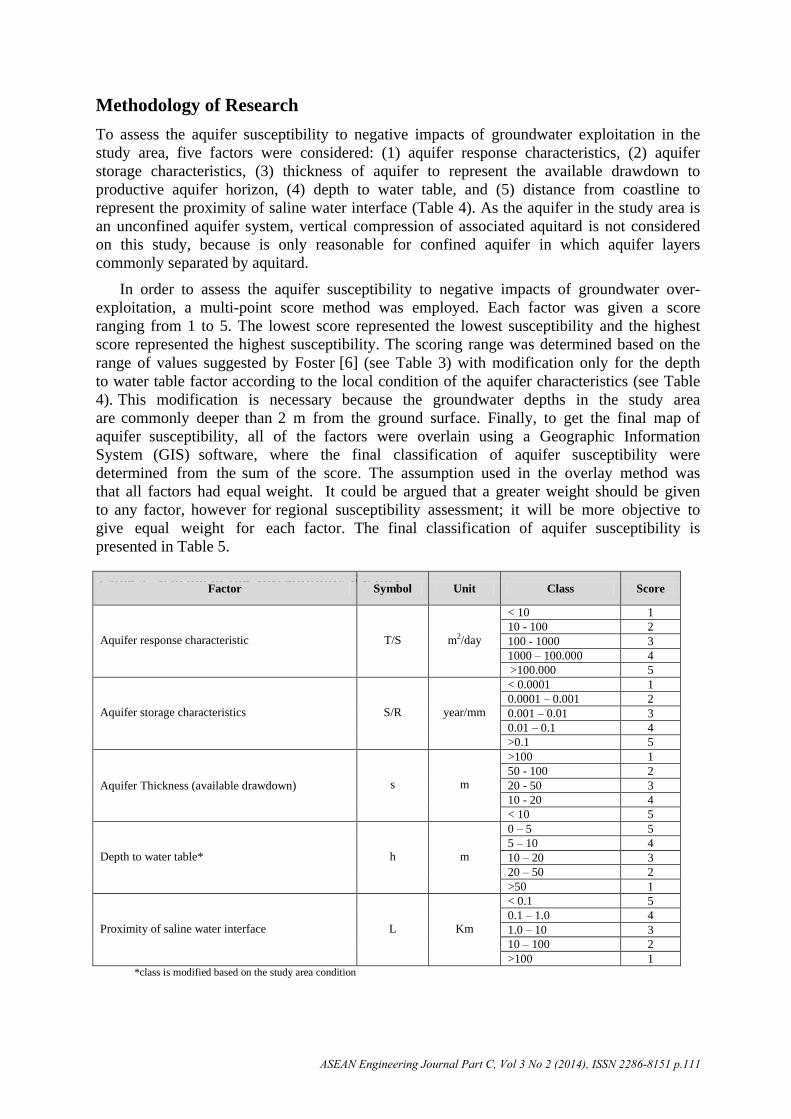
coarser deposits than the upper aquifer [7]. The thickness of the aquifer ranges from 20 to
120 m, but is very variable. The thickness of the aquifer is larger in the central part of the
basin and decreases to the direction of the basin boundaries [11]. The average hydraulic
conductivity of the aquifer system is about 8.64 m/d [7], while the average effective porosity
of the aquifer is about 20 % [2]. The hydraulic characteristics of the aquifers are listed in
Table 1. The regional groundwater flow in the study area is from north to south, where the
groundwater gradient varies from 1/50 in the north and 1/250 in the south [8].
ASEAN Engineering Journal Part C, Vol 3 No 2 (2014), ISSN 2286-8151 p.106
Figure 1. Location of Yogyakarta – Sleman groundwater basin (bordered by dash line)
South China Sea
Pacific Ocean
Arafura Sea
Indian Ocean
Kilometers
5000
300 Km0
ASEAN Engineering Journal Part C, Vol 3 No 2 (2014), ISSN 2286-8151 p.107
P R E C I P I T A T I O N
E V A P O T R A N S P I R A T I O N
Young Merapi Volcanic
Old Merapi Volcanic
Tertiary Sedimentary RocksSentolo Formation
Wates FormationSand Dunes
Sea
Interface
Springs
Groundwater surface
Sleman Formation
Yogyakarta FormationSaline Water Fresh
Water
NORTHSOUTH
Figure 2. South-North cross section of hydrogeological concept of aquifer in the Yogyakarta-
Sleman groundwater basin [8]
Table 1. Hydraulic Characteristics of Aquifer in the Yogyakarta-Sleman Groundwater
Basin
No. Aquifer Characteristics Unit Range of value
1 Transmissivity m2/day 10 – 3000
2 Hydraulic Conductivity m/day 3 – 700
3 Specific Capacity l/s/m 0.1 – 35
4 Specific Yield (upper aquifer layer) - 0.1 – 0.3
5 Storativity (lower aquifer layer) - 0.06 – 0.1
The specific yield and storativity indicate that the upper and lower aquifer layers can be
classified as unconfined aquifer type (Storativity ≈ 0.1). Both aquifers are therefore likely
hydraulically connected and groundwater exploitation on the lower aquifer will likely affect
the upper aquifer. This may lead to susceptibility due to pumping activities to the aquifers.
Negative Impacts of Groundwater Overexploitation
The groundwater over-exploitation is a concept that is still poorly defined. The term over-
exploitation tends to depend on a concept of “undesirable results” or “negative side-
effects” [1]. There are a number of well known consequences of groundwater exploitation
that may not be desirable, which are [9]:
Declining Groundwater Level and Decreasing Discharges of Spring, River Baseflow,
and Wetland Area
It is common for over-exploitation to be defined as the condition which exists when total
groundwater abstraction exceeds the recharge, giving rise to significant groundwater-level
decline [1]. However, most aquifers show a water level decline as part of a natural cycle,
even when they are not exploited, at least in some areas for part of the time. The water level
decline may be seasonal, during a normal dry season, or it may be a longer term in response
to a prolonged drought. During these periods, river and spring flows and discharge to
wetlands are provided by release of water from aquifer storage causing water levels in the
ASEAN Engineering Journal Part C, Vol 3 No 2 (2014), ISSN 2286-8151 p.108
aquifer to decline. Subsequent periods of recharge permit water levels to rise again as water is
brought back into aquifer storage. In case of overexploitation, water levels will not rise again
because no water is brought back into the aquifer storage [9].
Land Subsidence
A sedimentary formation is initially formed as a soft sand, silt or mud. As the sediment builds
up and subsequent layers are deposited, the increasing weight of the overburden compresses
the lower beds, but the system keeps in equilibrium because the intergranular stress in the
skeleton of the formation balances the weight of the overburden. Pressure of the water within
the pores between the individual sediment particles also helps to support some of this weight.
Groundwater pumping or dewatering of any sedimentary strata causes a decrease in the pore
water pressure and, subsequently, an increase in the effective stress of the overlying strata of
the aquifer. When the increase in effective stress is greater than a critical value, known as the
preconsolidation stress, the sediment compaction becomes irrecoverable or inelastic [9]. In
the multilayered aquifer system, cumulative compaction of the aquitard layers can result in
significant subsidence of the ground surface [1].
Deterioration in Groundwater Quality
The abstraction of significant amounts of groundwater can lead deterioration of water quality
by such means as induction of contaminant flow as a result of a new hydraulic head
distribution, saline intrusion, and geochemical evolution of groundwater [1]. Saline intrusion
is an important consideration for aquifers adjacent to the coast or other saline bodies. The
mobility of such saline waters depends upon the hydraulic gradients, which are locally
disturbed by groundwater abstraction, the permeability of the aquifer, and the presence or
absence of hydraulic barriers. A consideration of the time period involved in displacement of
a saline front is important to an assessment of over-exploitation. A displacement time of a
few years would be a matter of concern, indicating a high probability of ‘overexploitation’,
but hundreds or thousands of years could well be acceptable in the context of long-term
management strategies [9]. There is example of specific assessment method for sea water
intrusion on the coastal aquifer such as GALDIT Method [4].
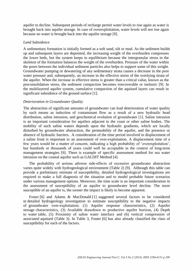
The probability of serious adverse side-effects of excessive groundwater abstraction
varies quite widely with hydrogeological environment (Table 2) [9]. Although this table can
provide a preliminary estimate of susceptibility, detailed hydrogeological investigations are
required to make a full diagnosis of the situation and to model probable future scenarios
under various management options. Moreover, the time scale is an important consideration in
the assessment of susceptibility of an aquifer to groundwater level decline. The more
susceptible of an aquifer is, the sooner the impact is likely to become apparent.
Foster [6] and Adams & MacDonald [1] suggested several factors to be considered
in detailed hydrogeology investigation to estimate susceptibility to the negative impacts of groundwater over-exploitation: (1) Aquifer response characteristics, (2) Aquifer storage characteristics, (3) Available drawdown to productive aquifer horizon, (4) Depth to water table, (5) Proximity of saline water interface and (6) vertical compression of
associated aquitard (Table 3). In Table 3, Foster [6] has also already classified the class of
susceptibility for each of the factors.
ASEAN Engineering Journal Part C, Vol 3 No 2 (2014), ISSN 2286-8151 p.109
Table 2. Susceptibility of Different Hydrogeological Settings to Adverse Side-Effects
during Excessive Abstraction [9]
Hydrogeological Setting
Type of Side-Effect
Saline
intrusion or
up-coning
Land
subsidence
Induced
pollution
Major alluvial and
coastal
coastal ++ ++ ++
Plain Sediments inland + + ++
Intermontane valley-
fill
With lacustrine deposits ++ ++ +
Without lacustrine deposits + + ++
With permeable
lavas/breccias
+ - ++
Without permeable
lavas/breccias
+ - +
Glacial deposits + + ++
Loessic plateau deposits + + -
Consolidated sedimentary aquifers ++ +* +
Recent coastal calcareous formations ++ - ++
Extensive volcanic terrains ++ - +
Weathered basement complex - - ++ ++ major effect + occurrences known - non applicable or rare
* can occur where associated with overlying aquitards
Table 3. Factors Affecting the Susceptibility of Aquifers to Adverse Side-Effects from
Excessive Abstraction [6]
Hydrogeology Factor Symbol Unit Susceptibility to adverse side-effects
T transmissivity m2/day, S storativity (dimensionless), R average recharge rate (mm/year)
The approach suggested by Foster [6] is to have a single measure of susceptibility which is related to groundwater level decline, saline/sea water intrusion and subsidence. The approach may not be pragmatic but it can show a general susceptibility map of potential impacts of groundwater over-exploitation.
ASEAN Engineering Journal Part C, Vol 3 No 2 (2014), ISSN 2286-8151 p.110
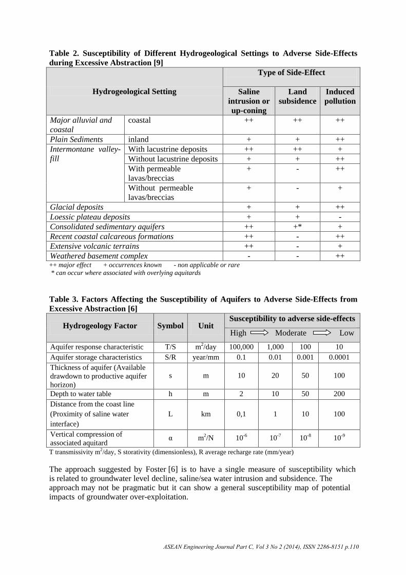
Methodology of Research
To assess the aquifer susceptibility to negative impacts of groundwater exploitation in the
study area, five factors were considered: (1) aquifer response characteristics, (2) aquifer
storage characteristics, (3) thickness of aquifer to represent the available drawdown to
productive aquifer horizon, (4) depth to water table, and (5) distance from coastline to
represent the proximity of saline water interface (Table 4). As the aquifer in the study area is
an unconfined aquifer system, vertical compression of associated aquitard is not considered
on this study, because is only reasonable for confined aquifer in which aquifer layers
commonly separated by aquitard.
In order to assess the aquifer susceptibility to negative impacts of groundwater over-
exploitation, a multi-point score method was employed. Each factor was given a score
ranging from 1 to 5. The lowest score represented the lowest susceptibility and the highest
score represented the highest susceptibility. The scoring range was determined based on the
range of values suggested by Foster [6] (see Table 3) with modification only for the depth
to water table factor according to the local condition of the aquifer characteristics (see Table
4). This modification is necessary because the groundwater depths in the study area
are commonly deeper than 2 m from the ground surface. Finally, to get the final map of
aquifer susceptibility, all of the factors were overlain using a Geographic Information
System (GIS) software, where the final classification of aquifer susceptibility were
determined from the sum of the score. The assumption used in the overlay method was
that all factors had equal weight. It could be argued that a greater weight should be given
to any factor, however for regional susceptibility assessment; it will be more objective to
give equal weight for each factor. The final classification of aquifer susceptibility is
presented in Table 5.
Table 4. Scoring of the Susceptibility Factors Factor Symbol Unit Class Score
Aquifer response characteristic T/S m2/day
< 10 1
10 - 100 2
100 - 1000 3
1000 – 100.000 4
>100.000 5
Aquifer storage characteristics S/R year/mm
< 0.0001 1
0.0001 – 0.001 2
0.001 – 0.01 3
0.01 – 0.1 4
>0.1 5
Aquifer Thickness (available drawdown) s m
>100 1
50 - 100 2
20 - 50 3
10 - 20 4
< 10 5
Depth to water table* h m
0 – 5 5
5 – 10 4
10 – 20 3
20 – 50 2
>50 1
Proximity of saline water interface L Km
< 0.1 5
0.1 – 1.0 4
1.0 – 10 3
10 – 100 2
>100 1 *class is modified based on the study area condition
ASEAN Engineering Journal Part C, Vol 3 No 2 (2014), ISSN 2286-8151 p.111
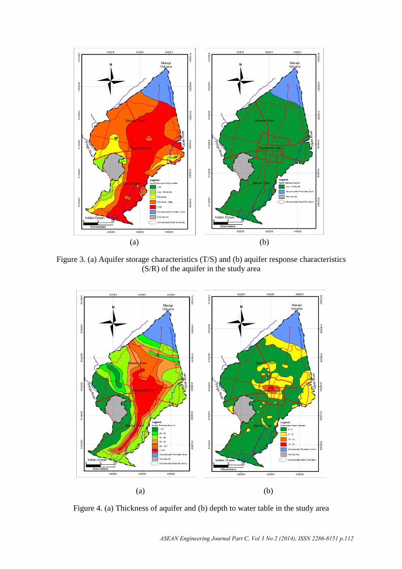
Figure 4. (a) Thickness of aquifer and (b) depth to water table in the study area
ASEAN Engineering Journal Part C, Vol 3 No 2 (2014), ISSN 2286-8151 p.112
(a) (b)
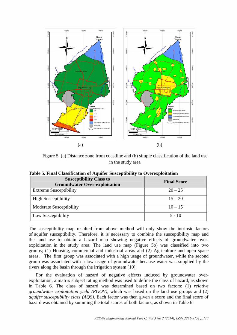
Figure 5. (a) Distance zone from coastline and (b) simple classification of the land use
in the study area
Table 5. Final Classification of Aquifer Susceptibility to Overexploitation
Susceptibility Class to
Groundwater Over-exploitation Final Score
Extreme Susceptibility 20 – 25
High Susceptibility 15 – 20
Moderate Susceptibility 10 – 15
Low Susceptibility 5 - 10
The susceptibility map resulted from above method will only show the intrinsic factors
of aquifer susceptibility. Therefore, it is necessary to combine the susceptibility map and
the land use to obtain a hazard map showing negative effects of groundwater over-
exploitation in the study area. The land use map (Figure 5b) was classified into two
groups; (1) Housing, commercial and industrial areas and (2) Agriculture and open space
areas. The first group was associated with a high usage of groundwater, while the second
group was associated with a low usage of groundwater because water was supplied by the
rivers along the basin through the irrigation system [10].
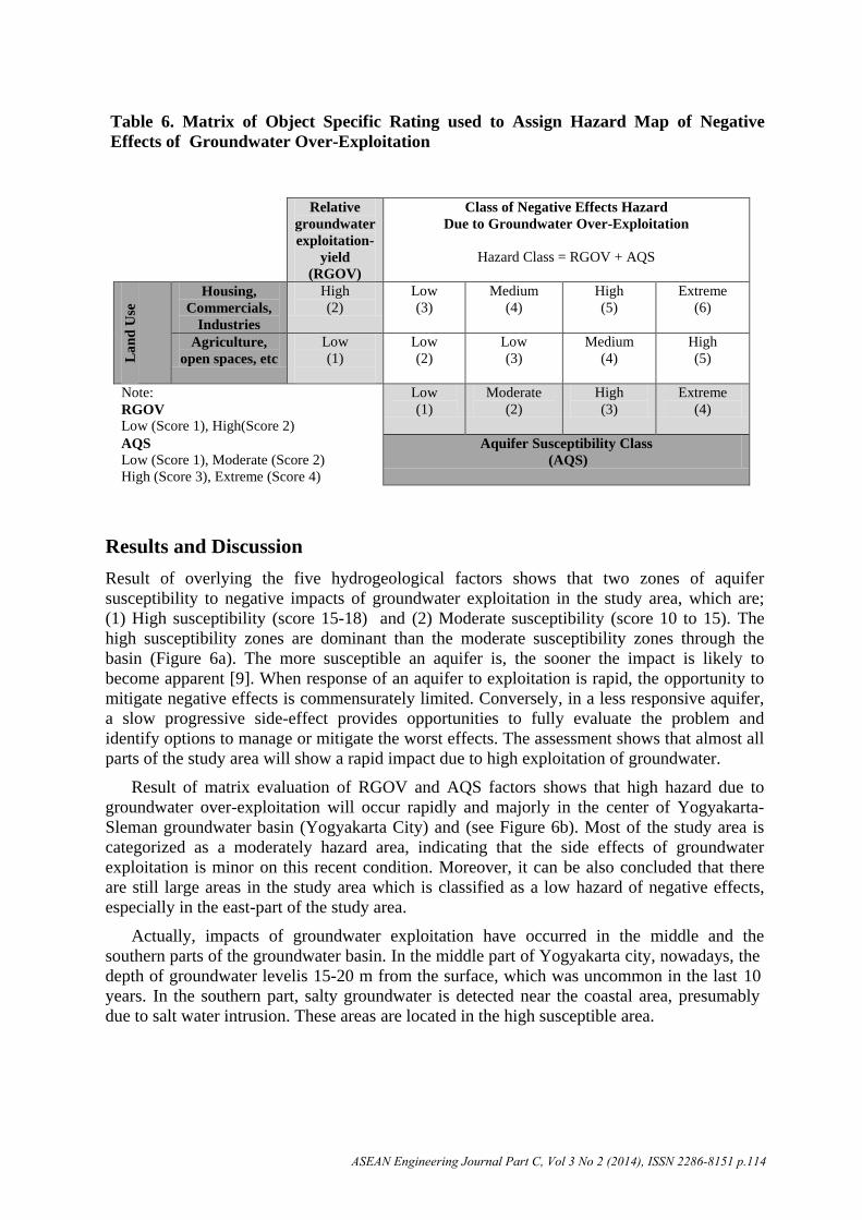
For the evaluation of hazard of negative effects induced by groundwater over-
exploitation, a matrix subject rating method was used to define the class of hazard, as shown
in Table 6. The class of hazard was determined based on two factors: (1) relative
groundwater exploitation yield (RGOV), which was based on the land use groups and (2)
aquifer susceptibility class (AQS). Each factor was then given a score and the final score of
hazard was obtained by summing the total scores of both factors, as shown in Table 6.
ASEAN Engineering Journal Part C, Vol 3 No 2 (2014), ISSN 2286-8151 p.113
Table 6. Matrix of Object Specific Rating used to Assign Hazard Map of Negative
Effects of Groundwater Over-Exploitation
Relative
groundwater
exploitation-
yield
(RGOV)
Class of Negative Effects Hazard
Due to Groundwater Over-Exploitation
Hazard Class = RGOV + AQS
La
nd
Use
Housing,
Commercials,
Industries
High
(2)
Low
(3)
Medium
(4)
High
(5)
Extreme
(6)
Agriculture,
open spaces, etc
Low
(1)
Low
(2)
Low
(3)
Medium
(4)
High
(5)
Note:
RGOV
Low (Score 1), High(Score 2)
Low
(1)
Moderate
(2)
High
(3)
Extreme
(4)
AQS
Low (Score 1), Moderate (Score 2)
High (Score 3), Extreme (Score 4)
Aquifer Susceptibility Class
(AQS)
Results and Discussion
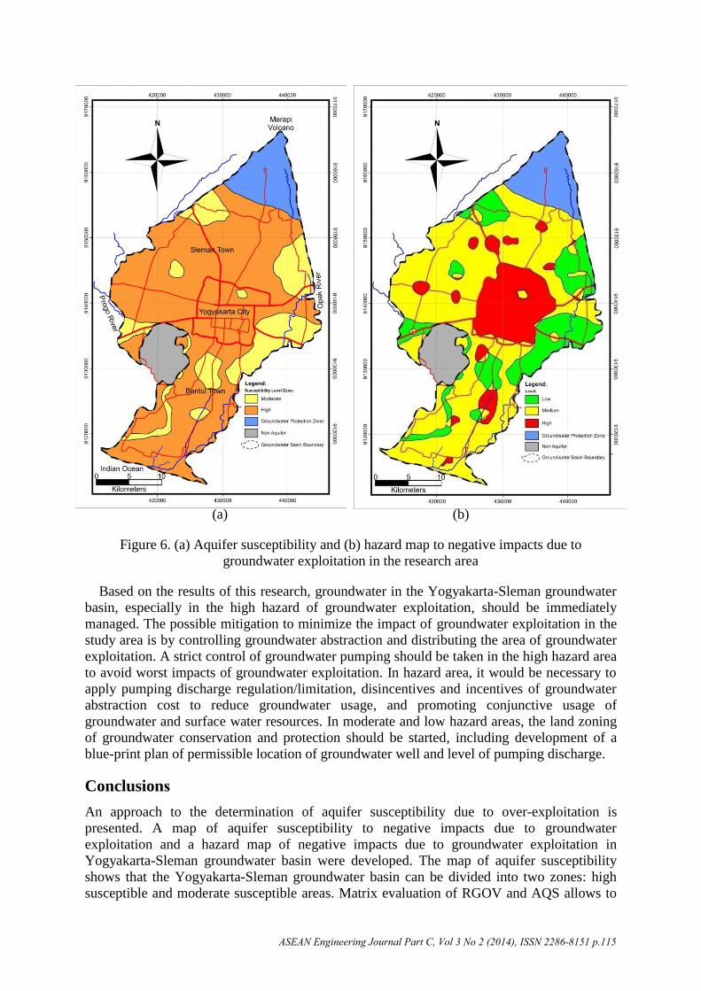
Result of overlying the five hydrogeological factors shows that two zones of aquifer
susceptibility to negative impacts of groundwater exploitation in the study area, which are;
(1) High susceptibility (score 15-18) and (2) Moderate susceptibility (score 10 to 15). The high susceptibility zones are dominant than the moderate susceptibility zones through the basin (Figure 6a). The more susceptible an aquifer is, the sooner the impact is likely to become apparent [9]. When response of an aquifer to exploitation is rapid, the opportunity to mitigate negative effects is commensurately limited. Conversely, in a less responsive aquifer, a slow progressive side-effect provides opportunities to fully evaluate the problem and identify options to manage or mitigate the worst effects. The assessment shows that almost all parts of the study area will show a rapid impact due to high exploitation of groundwater.
Result of matrix evaluation of RGOV and AQS factors shows that high hazard due to
groundwater over-exploitation will occur rapidly and majorly in the center of Yogyakarta-
Sleman groundwater basin (Yogyakarta City) and (see Figure 6b). Most of the study area is
categorized as a moderately hazard area, indicating that the side effects of groundwater
exploitation is minor on this recent condition. Moreover, it can be also concluded that there
are still large areas in the study area which is classified as a low hazard of negative effects,
especially in the east-part of the study area.
Actually, impacts of groundwater exploitation have occurred in the middle and the
southern parts of the groundwater basin. In the middle part of Yogyakarta city, nowadays, the
depth of groundwater levelis 15-20 m from the surface, which was uncommon in the last 10
years. In the southern part, salty groundwater is detected near the coastal area, presumably
due to salt water intrusion. These areas are located in the high susceptible area.
ASEAN Engineering Journal Part C, Vol 3 No 2 (2014), ISSN 2286-8151 p.114
(a) (b)
Figure 6. (a) Aquifer susceptibility and (b) hazard map to negative impacts due to
groundwater exploitation in the research area
Based on the results of this research, groundwater in the Yogyakarta-Sleman groundwater
basin, especially in the high hazard of groundwater exploitation, should be immediately
managed. The possible mitigation to minimize the impact of groundwater exploitation in the
study area is by controlling groundwater abstraction and distributing the area of groundwater
exploitation. A strict control of groundwater pumping should be taken in the high hazard area
to avoid worst impacts of groundwater exploitation. In hazard area, it would be necessary to
apply pumping discharge regulation/limitation, disincentives and incentives of groundwater
abstraction cost to reduce groundwater usage, and promoting conjunctive usage of
groundwater and surface water resources. In moderate and low hazard areas, the land zoning
of groundwater conservation and protection should be started, including development of a
blue-print plan of permissible location of groundwater well and level of pumping discharge.
ConclusionsAn approach to the determination of aquifer susceptibility due to over-exploitation is
presented. A map of aquifer susceptibility to negative impacts due to groundwater
exploitation and a hazard map of negative impacts due to groundwater exploitation in
Yogyakarta-Sleman groundwater basin were developed. The map of aquifer susceptibility
shows that the Yogyakarta-Sleman groundwater basin can be divided into two zones: high
susceptible and moderate susceptible areas. Matrix evaluation of RGOV and AQS allows to
ASEAN Engineering Journal Part C, Vol 3 No 2 (2014), ISSN 2286-8151 p.115
develop a hazard map due to groundwater exploitation. The matrix evaluation indicates there
are three zones of hazard in the study area; low, medium and high hazard areas associated
with the side effects of groundwater over-exploitation occurring in the study area, such as
declining of groundwater level in the Yogyakarta City and salt water intrusion in the coastal
area.
The modification of aquifer susceptibility assessment reported on this paper, has some
limitations, such as the equal weight assumption and simple matrix assessment. However, the
assessment results were proven to be correlated with the occurring negative impacts
of groundwater exploitation in the study area. The modified concept of assessment is,
therefore, considered to be appropriate to be used on regional basis and the developed
maps may help stakeholders/planners on groundwater resources in the study area to
mitigate the negative impacts of groundwater over-exploitation.
References
[1] B. Adams, and A.M. MacDonald, “Aquifer susceptibility to side-effects of groundwater exploitation,” In Groundwater Pollution, Aquifer Recharge and Vulnerability, N.S. Robins, ed.: Geological Society, London, Special Publication, Vol. 130, pp. 71-76, 1998.
[2] A. Consult, Yogyakarta Water Supply Extension Project, Bedog and Karanggayam, Wellfields Hydrogeology and Well Drilling, Directorate of Human Settlements, Ministry of Public Works, Goverment of the Republic Indonesia, 1989.
[3] A.M. Baiquni, “Urbanization and urban settlement dualism: A case study and research of Yogyakarta, Indonesia,” In: Proceedings of International Workshop on Asian Approach Toward Sustainable Urban Regeneration, The University of Tokyo, Japan, September 2004.
[4] A.G. Chachadi, and J.P. Lobo-Ferreira, “Seawater Intrusion Vulnerability Mapping of Aquifers Using GALDIT Method,” In: Proceedings of the Workshop on Modelling in Hydrogeology, Anna University, Chennai, pp. 143-156, 2001.
[5] A. Djaeni, Peta hidrogeologi Indonesia skala, 1:250.000, Lembar IX Yogyakarta, Direktorat Geologi Tata Lingkungan, Bandung, 1982.
[6] S.S.D. Foster, “Unsustainable development and irrational expolitation of groundwater resourcesin developing nations – An overview,” International Association of Hydrogeologist, Vol. 3, pp. 321-336, 1992.
[7] H. Hendrayana, Hydrogeologie und Groundwassergewinnung im Yogyakarta Becken, Indonesien, Thesis (PhD), RWTH-Aachen, 1993.
[8] MacDonald and Partners, Greater Yogyakarta Groundwater Resources Study, Vol. 3, Directorate General of Water Resources Groundwater Development Project (P2AT), Ministry of Public Works, Government of The Republic of Indonesia, 1984.
[9] B.L. Morris, A.R. Lawrence, P.J.C. Chilton, B. Adams, R.C. Calow, and B.A. Klinck, Groundwater and its susceptibility to degradation: A global assessment of the problem and options for management, Early Warning and Assessment Report Series, RS.03-3. United Nations Environment Programme, Nairobi, Kenya, 2003.
[10] D.P.E. Putra, Integrated Water Resources Management in Merapi – Yogyakarta Basin, Research Support Program, AUNSeed/net – Fakultas Teknik Universitas Gadjah Mada, 2003.
[11] D.P.E. Putra, The Impact of Urbanization of Groundwater Quality – A Case Study in Yogyakarta City – Indonesia, Herausgegeben Vom (Lehrstuhl) fuer Ingenieurgeologie und Hydrogeologie, University Prof. Dr. Azzam, RWTH, Aachen, Germany, 2007.
ASEAN Engineering Journal Part C, Vol 3 No 2 (2014), ISSN 2286-8151 p.116


![Cardiotoxicity of yew aremoreeffective[8].Ifsuchtreatmentisnoteffective and the patient's consciousness is depressed due to the development of cardiogenic shock, complex resuscitation](https://static.dokumenty.site/doc/80x56/5c927a8a09d3f23a2e8d1e80/cardiotoxicity-of-yew-aremoreeffective8ifsuchtreatmentisnoteffective-and-the.jpg)


