20
24/09/2015 Padova (IT) On the role of subsurface heterogeneity at hillslope scale with Parflow Gabriele Baroni Sabine Attinger
| Date post: | 26-Jan-2017 |
| Category: |
Science |
| Upload: | coupledhydrologicalmodeling |
| View: | 170 times |
| Download: | 0 times |
24/09/2015
Padova (IT)
On the role of subsurface
heterogeneity at hillslope
scale with Parflow
Gabriele Baroni
Sabine Attinger

Outline
Quick overview of the project
Motivations in our research unit
The effect of soil heterogeneity at field/hillslope
Outlook
2
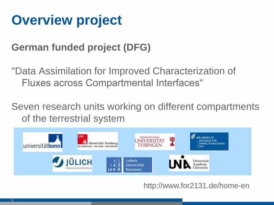
Overview project
German funded project (DFG)
"Data Assimilation for Improved Characterization of
Fluxes across Compartmental Interfaces“
Seven research units working on different compartments
of the terrestrial system
3
http://www.for2131.de/home-en
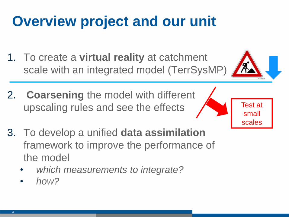
Overview project and our unit
1. To create a virtual reality at catchment
scale with an integrated model (TerrSysMP)
2. Coarsening the model with different
upscaling rules and see the effects
3. To develop a unified data assimilation
framework to improve the performance of
the model • which measurements to integrate?
• how?
4
Test at
small
scales
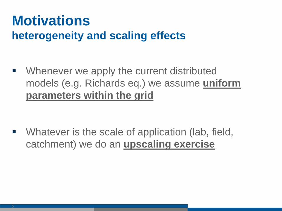
Motivations heterogeneity and scaling effects
Whenever we apply the current distributed
models (e.g. Richards eq.) we assume uniform
parameters within the grid
Whatever is the scale of application (lab, field,
catchment) we do an upscaling exercise
5

Research questions in this upscaling exercise?
we have to find upscaling rules/effective
parameters
• different results functions of domain set-up,
parameters distributions, boundary conditions etc.
• Holy Grail of hydrology…worth searching for
even if a general solution might ultimate prove
impossible to find (Beven, 2006)
6
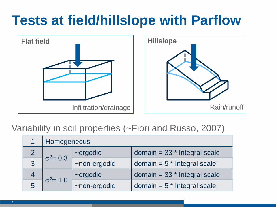
Hillslope
Rain/runoff
Flat field
Infiltration/drainage
Tests at field/hillslope with Parflow
Variability in soil properties (~Fiori and Russo, 2007)
7
1 Homogeneous
2 s2= 0.3
~ergodic domain = 33 * Integral scale
3 ~non-ergodic domain = 5 * Integral scale
4 s2= 1.0
~ergodic domain = 33 * Integral scale
5 ~non-ergodic domain = 5 * Integral scale
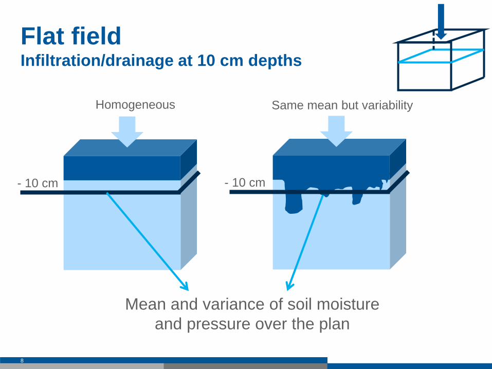
Same mean but variability
Flat field Infiltration/drainage at 10 cm depths
8
Homogeneous
Mean and variance of soil moisture
and pressure over the plan
- 10 cm - 10 cm
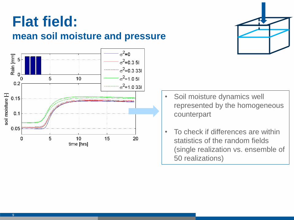
Flat field: mean soil moisture and pressure
9
• Soil moisture dynamics well
represented by the homogeneous
counterpart
• To check if differences are within
statistics of the random fields
(single realization vs. ensemble of
50 realizations)
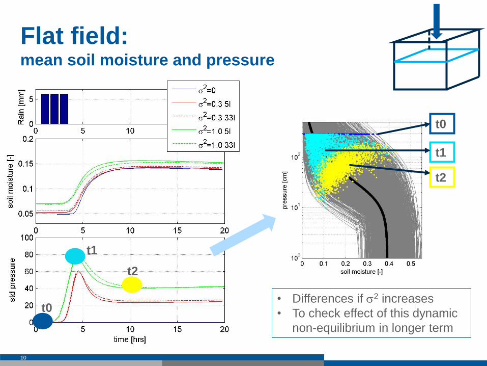
Flat field: mean soil moisture and pressure
10
• Differences if s2 increases
• To check effect of this dynamic
non-equilibrium in longer term
t0
t1
t2
t0
t1
t2
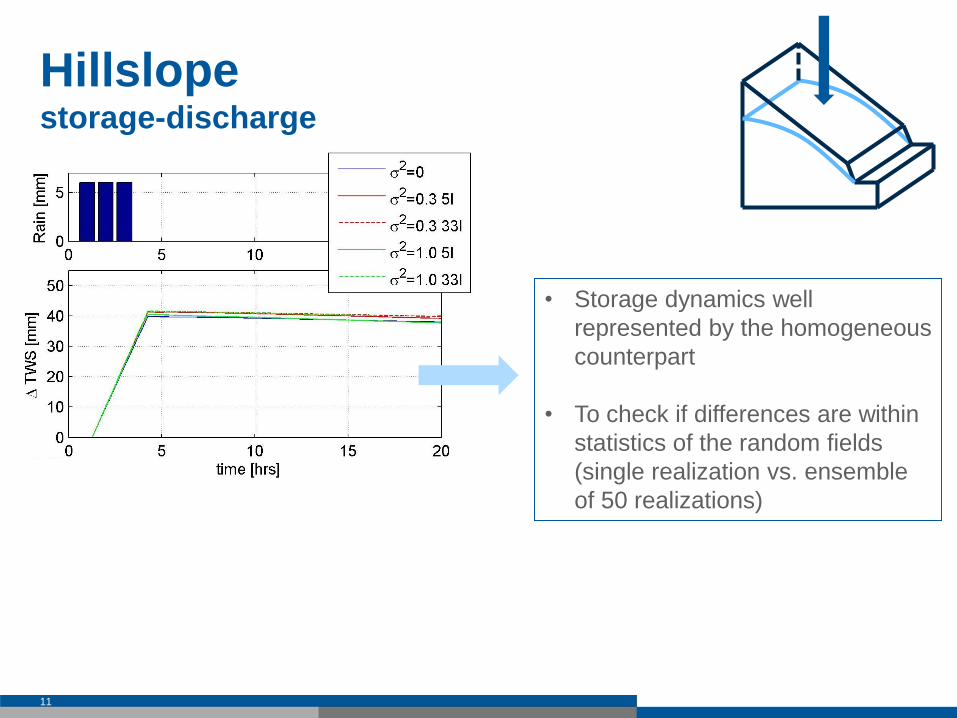
Hillslope storage-discharge
11
• Storage dynamics well
represented by the homogeneous
counterpart
• To check if differences are within
statistics of the random fields
(single realization vs. ensemble
of 50 realizations)
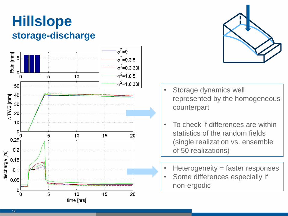
Hillslope storage-discharge
12
• Storage dynamics well
represented by the homogeneous
counterpart
• To check if differences are within
statistics of the random fields
(single realization vs. ensemble
of 50 realizations)
• Heterogeneity = faster responses
• Some differences especially if
non-ergodic
To summarize so far…
With an homogeneous counterpart
state dynamic well represented (i.e., soil
moisture or water storage)
variability increases dynamic non–equilibrium
but to test implications at longer term
non-ergodicity - more than variability - precludes
the use of general upscaling rules
13

To come…
To generalize the tests at field/hillslope scale to
better understand the role of soil heterogeneity on
the hydrological responses
To finalize the virtual reality and to analyse the
effect of coarsening with different upscaling rules
at catchment scale
14

…but a working hypothesis
15
Model
results
GOOD
BAD
Fine
grid Coarse
grid
e.g.,
topography soil
Ergodic D>>I
grid resolution
From searching for effective parameters to search for best resolution?
grid resolution
GOOD
BAD
Fine
grid Coarse
grid
Model
results
? Best
resolution?
Non-ergodic D ~ I
at this scale we might still have uncertainty in state and discharge
(fluxes): DA framework to integrate both measurements and to
compensate the model structure uncertainty

Thank you for the attention
16

Virtual reality
17
Neckar Catchment: Location (Baden-Württemberg, Germany)
Area 14,000 km2
Temperate-Humid climate
Average annual precipitation 950mm
Medium groundwater depth (1-2m)
Model set-up
Different virtual realities
~ resolution 50 – 800 m
~ 30 million nodes
~ 5 -12 years of simulation runs
We aim at a reasonable approximation
Plausible check with measurements
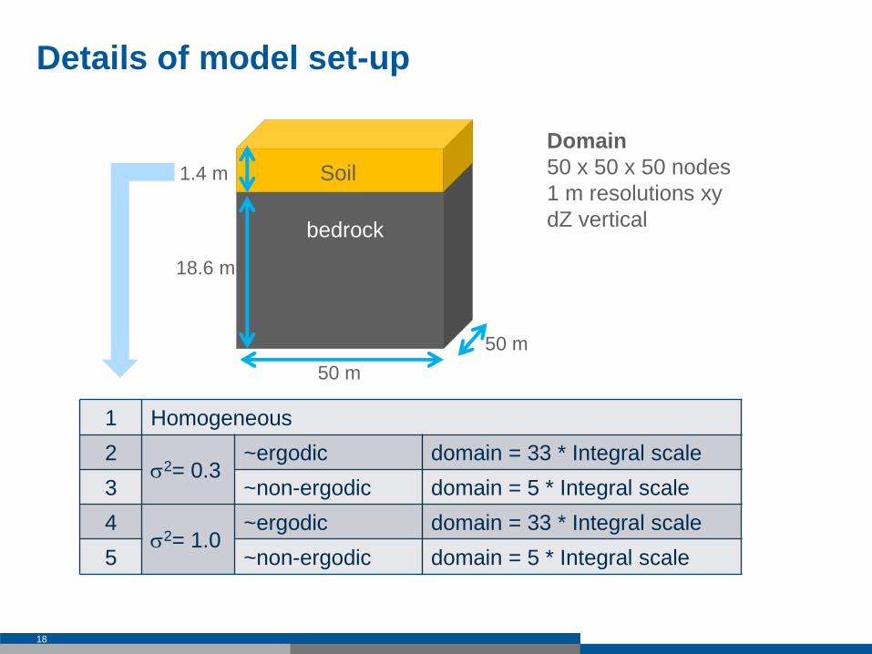
Details of model set-up
18
1 Homogeneous
2 s2= 0.3
~ergodic domain = 33 * Integral scale
3 ~non-ergodic domain = 5 * Integral scale
4 s2= 1.0
~ergodic domain = 33 * Integral scale
5 ~non-ergodic domain = 5 * Integral scale
Soil
Domain
50 x 50 x 50 nodes
1 m resolutions xy
dZ vertical bedrock
1.4 m
18.6 m
50 m
50 m
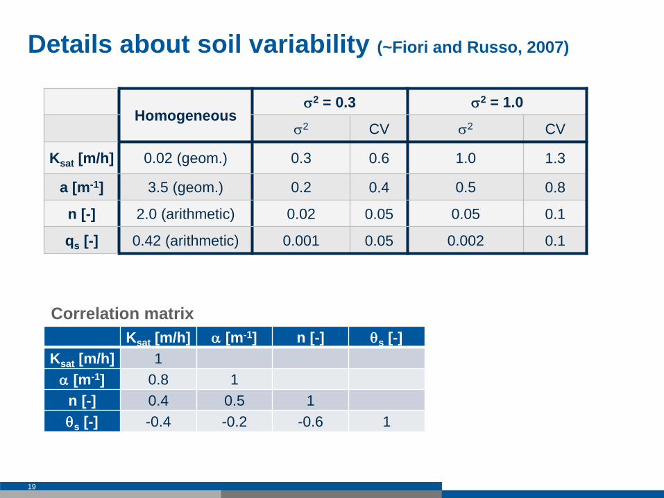
Details about soil variability (~Fiori and Russo, 2007)
19
Homogeneous
s2 = 0.3 s2 = 1.0
s2 CV s2 CV
Ksat [m/h] 0.02 (geom.) 0.3 0.6 1.0 1.3
a [m-1] 3.5 (geom.) 0.2 0.4 0.5 0.8
n [-] 2.0 (arithmetic) 0.02 0.05 0.05 0.1
qs [-] 0.42 (arithmetic) 0.001 0.05 0.002 0.1
Ksat [m/h] a [m-1] n [-] qs [-]
Ksat [m/h] 1
a [m-1] 0.8 1
n [-] 0.4 0.5 1
qs [-] -0.4 -0.2 -0.6 1
Correlation matrix
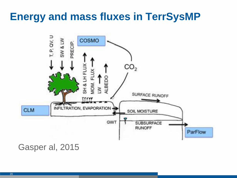
Energy and mass fluxes in TerrSysMP
20
Gasper al, 2015


