2
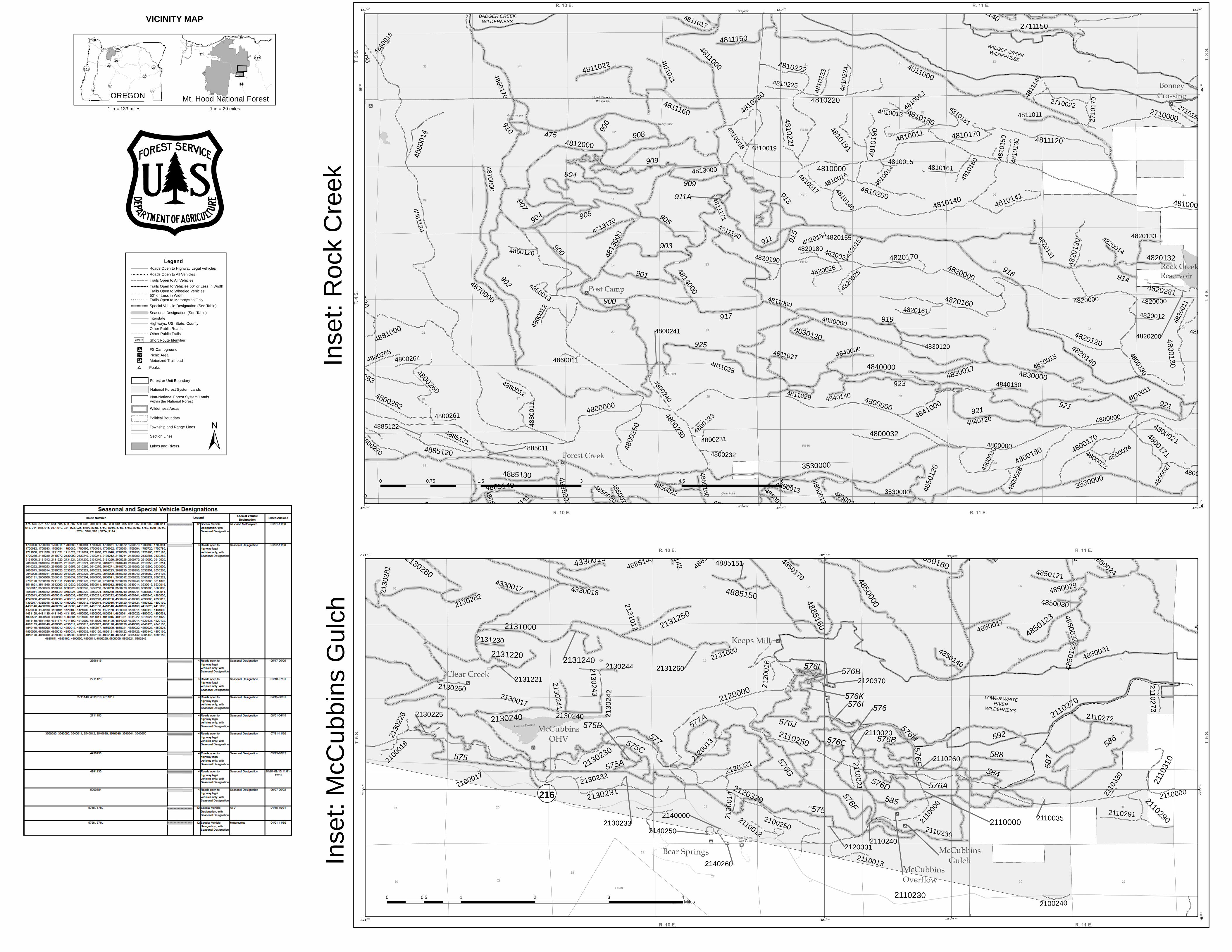
VICINITY MAP No r t h Amer i can Dat um o f 1983 ( NAD 83 ) Un i ver sal T r ansver se M er cat o r , zone 10 FS- 873 - 606 Clackamas Lake Bear Springs Post Camp Nottingham Frog Lake Little Crater Kinni Kinnik Rock Creek Reservoir Alpine Devils Half Acre Cloud Cap Saddle Trillium Lake Sherwood Knebal Springs till Creek Barlow Crossing Eight Mile White River Station Clear Creek Pebble Ford Ned Underhill McCubbins OHV Grindstone Barlow Creek Forest Creek Lower Eight Mile Crossing Boulder Lake Keeps Mill Tilly Jane Polallie Clear Lake Fifteen Mile McCubbins Overflow Little Badger Bonney Meadows Badger Lake Bonney Crossing McCubbins Gulch 2140000 2650000 351200 4400240 5000124 1700780 3545620 210240 2120331 3550221 21017 3530280 3550000 3540650 2651000 3500740 485143 480001 265618 1700642 2645060 2656130 4860160 2710150 2131260 3500650 2600850 2130232 210260 48171 2630220 35101 4840120 5800013 3530270 480550 270120 2645030 3500720 4800273 4400640 210035 485031 2600065 48301 1700650 4400624 1700014 3545650 488501 4820200 2650035 3500775 5800222 4810019 481012 5000015 483015 3500730 4270231 4885122 4820151 5800014 16100 2720015 4885151 3550240 2656037 2645105 2130233 4820024 3500221 4820155 427014 48027 21030 3560012 210221 2100 485141 4200015 2600014 2610241 1720150 481018 2656013 4810015 3500743 410120 4850032 2131012 2640220 4300250 1631630 2600066 1610650 4850170 2120370 350773 210272 2645040 4800030 1610670 1700643 4810013 4850029 2130244 2710012 1700691 4820190 1700000 4810160 356001 48023 4012 40140 2120321 4800015 485024 3530260 4800531 4810150 213100 48190 4200034 4330018 3530220 4800019 4280250 2660222 48024 4850012 4800014 2630260 410140 4850122 3500630 2600064 4800231 3500122 2131221 4800532 356022 2130281 4850030 2600140 2656024 481027 4400014 481014 4800232 4820180 1640000 350750 481028 3531000 4800150 4800261 2710013 2120014 48018 1600620 4200000 2130242 35401 353016 4885142 48023 4820012 4290220 5890250 210000 489120 1720160 2610253 2660014 263020 2610251 4820154 4200210 3500012 2630223 2131230 2640221 486001 4300220 2600530 2140260 2610257 2710131 4800520 4820280 485021 3560241 213017 171640 4800264 1700641 4430150 265615 4270220 3540630 481001 2130220 210310 4885150 261000 4810191 40631 42001 266021 4820170 40180 2610025 350001 410190 4830130 46000 48017 170013 4200221 2130240 4885130 5801 410180 2610024 263000 48102 4830017 4850160 481016 4810190 4400122 2630014 3512640 48020 3530053 210290 2610020 2131240 2630250 2131220 420246 48150 4820281 2610230 4810230 17000 4810170 3512620 1612641 43140 4280240 2131250 170630 260015 481022 480140 2610255 260016 480171 48013 1612670 4880014 488130 1710644 266000 26028 2610240 4810221 440191 4885160 3550222 420160 2100220 4810180 40121 171624 260210 2650131 3560221 1700673 351012 264000 1710630 1650650 4400015 48012 264001 4885120 480230 271001 350640 2730230 4850123 40170 1612630 2730240 1610630 4330019 356020 210230 4800032 440140 430017 484100 170670 420270 171620 263020 480262 4810200 4810141 4820132 351620 410130 170640 17100 2630230 351621 488120 4330013 480250 354500 17061 3530014 210000 2720120 40130 480530 270013 4820130 27150 1710640 170690 3530017 480170 260470 48160 500120 2640240 3530240 48021 3540012 2710015 480263 4450000 4280241 480260 480180 4200013 164060 212000 2130000 3560240 4200240 35500 265120 442150 48120 4850023 489100 431000 42000 2130231 2700120 4400000 4400000 43120 4300260 3510 410620 2710130 2610260 171621 440190 4820160 4885140 163060 2130280 4800130 1640620 2656254 1612640 430014 5800220 355000 27140 2730170 270 4820120 420241 430140 261020 172160 1700680 266020 163100 3540640 4810140 27101 2130230 488000 42020 270130 2120320 161000 4810220 42000 1700660 170014 170684 210250 3540 481300 488100 1720180 2720160 353100 4891250 4290000 40620 2100240 3550250 3500120 210021 353015 4850160 4860170 170672 2610271 21012 2612126 21016 3530250 2710014 481015 580221 2610023 485014 2656080 4860120 1600014 3500642 1700685 2140250 2120016 2660012 4850013 4890220 1700693 4830120 210250 2130226 2640223 353013 5000384 3500150 2130260 482014 2130225 4800028 4300 1612650 2610280 1600015 2656019 2610290 2610250 481016 4810130 3560230 210273 5800016 2720161 2610272 210020 161001 170682 1700720 1800008 4810161 1631620 4840140 350641 1700681 2610231 350630 4203 210291 480580 486013 4840130 172161 4810223 4810225 1700740 2600149 4420180 1700683 4330017 2630221 4870000 48015 2656120 4891231 263022 4200222 480265 48140 3530012 481029 2130241 266001 2130282 4800241 43015 4400630 42016 481017 5890000 171623 260226 350135 3530054 488001 4820131 4810224 410660 485121 4850140 26100 480271 42100 16500 2710170 3500620 485017 4280220 4813000 3560224 480270 2630013 1710645 48502 1700671 1700692 485026 4820000 42160 2710160 482001 489130 4200240 489001 480581 1720230 2630251 4810181 4810140 2660013 2130243 3512630 3540641 4850121 210013 4800171 482025 48016 2710022 481021 43150 4820133 442150 3500220 2610220 480240 261200 1610640 4300221 480272 4820026 2130240 420161 43130 428012 2610252 351640 4860012 1700 480130 212013 1700694 4813120 2610270 2730190 4891240 1640630 1710640 481017 4820161 48101 48012 410131 485020 4400622 4891230 488124 2610221 2720162 173 216 216 35 35 35 26 26 171630 4885000 43020 284000 210270 42100 42100 2610250 2710140 430230 27100 1640000 40120 265600 481400 4820140 3500680 440160 4812000 353001 160020 2730200 356000 486000 163000 4850120 4860140 27120 4840000 2131000 2730000 43000 162000 433000 43100 4870 483000 48100 1722000 1300000 41000 264500 1800000 482000 4890000 351000 272000 161200 43000 44000 4810000 172000 485000 271000 351200 48000 48000 48000 353000 353000 3530000 16000 1600000 4270230 4270000 580 5800000 170680 1700680 210230 172000 44000 45000 2730000 270 27000 271000 48100 4810000 3530 4840000 481000 4830000 48000 4800000 4800000 4820000 353000 3530000 35 26 576D 911A 576H 576L 576E 576I 914 575B 576K 576G 575C 576J 910 906 908 915 576C 575A 587 917 903 901 577A 907 576F 588 576A 921 SNO-762 592 923 925 475 909 585 905 919 902 900 576 586 584 913 916 911 904 577 576B 575 575 905 909 904 900 921 921 576B LOWER WHITE RIVER WILDERNESS LOWER WHITE RIVER WILDERNESS (BLM) MOUNT HOOD WILDERNESS M O U N T H O O D W I L D E R N E S S MOUNT HOOD WILDERNESS M O U N T H O O D W I L D E R N E S S B A D G E R C R E E K W I L D E R N E S S B A D G E R C R E E K W I L D E R N E S S Hood River Co. Wasco Co. Hood River Co. Wasco Co. Hood River Co. Wasco Co. Hood River Co. Wasco Co. H o o d R i v e r C o . Clackamas Co. Wasco Co. C la cka m as C o. H oo d R iver R an ge r Di strict Ba rlo w Ranger Dist ric t H o od R i v e r R a n g e r D i s t ri ct B a r l o w R a n g e r D i s t r ic t H o o d R i v e r R a n g e r D i s t r ict Barlow Ranger District Ho o d R i ve r R a nger D i st ri ct B a rlo w Ra n g e r D i str ict H o od R iv er Ra n ge r D is t r i ct Z igz a g R an g e r D is tri ct H o od R i v e r R a n g er D i s t r i c t Zi gz a g R a n g e r D i s t r i ct 20 21 22 23 24 25 26 27 28 29 32 33 34 35 36 19 20 21 22 23 24 25 26 27 28 29 30 31 32 33 34 35 36 25 26 27 28 29 30 31 32 33 34 35 36 25 26 27 28 29 30 31 32 33 34 35 36 25 26 27 28 29 30 31 32 33 34 35 36 30 31 01 02 03 04 05 06 07 08 09 10 1 12 13 14 15 16 17 18 19 20 21 22 23 24 25 26 27 28 29 30 31 32 33 34 35 36 01 02 03 04 05 06 07 08 09 10 1 12 13 14 15 16 17 18 19 20 21 22 23 24 25 26 27 28 29 30 31 32 33 34 35 36 01 02 03 04 05 06 07 08 09 10 1 12 13 14 15 16 17 18 19 20 21 22 23 24 25 26 27 28 29 30 31 32 33 34 35 36 01 02 03 04 05 06 07 08 09 10 1 12 13 14 15 16 17 18 19 20 21 22 23 24 25 26 27 28 29 30 31 32 33 34 35 36 01 02 03 04 05 06 07 08 09 10 1 12 13 14 15 16 17 18 19 20 21 22 23 24 25 26 27 28 29 30 31 32 33 34 35 36 P B37 P B40 08 17 20 29 P B37 P B38 P B39 P B40 P B41 P B42 P B43 P B44 P B45 P B46 P B47 P B49 P B50 P B51 P B52 P B53 31 07 08 09 10 1 14 15 16 17 18 19 20 21 22 23 26 27 28 29 30 01 02 03 04 05 06 07 08 09 10 1 12 13 14 15 16 17 18 19 20 21 22 23 24 25 26 27 28 29 30 31 32 33 34 35 36 01 02 03 04 05 06 07 08 09 10 1 12 13 14 15 16 17 18 19 20 21 22 23 24 25 26 27 28 29 30 31 32 33 34 35 36 01 02 03 04 05 06 07 08 09 10 1 12 13 14 15 16 17 18 19 20 21 22 23 24 25 26 27 28 29 30 31 32 33 34 35 36 01 02 03 04 05 06 07 08 09 10 1 12 13 14 15 16 17 18 19 20 21 22 23 24 25 26 27 28 29 30 31 32 33 34 35 36 01 12 13 24 25 36 01 02 03 04 05 06 07 08 09 10 1 12 13 14 15 16 17 18 19 20 21 22 23 24 25 26 27 28 29 30 31 32 33 34 35 36 01 02 03 04 05 06 07 08 09 10 1 12 13 14 15 16 17 18 19 20 21 22 23 24 25 26 27 28 29 30 31 32 33 34 35 36 01 02 03 04 05 06 07 08 09 10 1 12 13 14 15 16 17 18 19 20 21 22 23 24 25 26 27 28 29 30 31 32 33 34 35 36 01 02 03 04 05 06 07 08 09 10 1 12 13 14 15 16 17 18 19 20 21 22 23 24 25 26 27 28 29 30 31 32 33 34 35 36 01 02 03 04 05 06 07 08 09 10 1 12 13 14 15 16 17 18 19 20 21 22 23 24 25 26 27 28 29 30 31 32 33 34 35 36 01 12 13 24 25 36 01 02 03 04 05 06 07 08 09 10 1 12 13 14 15 16 17 18 19 20 21 22 23 24 25 26 27 28 29 30 31 32 33 34 35 36 01 02 03 04 05 06 07 08 09 10 1 12 13 14 15 16 17 18 19 20 21 22 23 24 25 26 27 28 29 30 31 32 33 34 35 36 P B37 P B38 P B39 P B40 P B41 P B42 P B43 P B44 P B45 P B46 01 02 03 04 05 09 10 1 12 13 14 15 16 20 21 22 23 24 25 26 27 28 29 31 32 33 34 35 36 01 02 03 04 05 06 07 08 09 10 1 12 13 14 15 16 17 18 19 20 21 22 23 24 25 26 27 28 29 30 31 32 33 34 35 36 01 02 03 04 05 06 07 08 09 10 1 12 1 14 15 16 17 18 19 20 21 22 23 26 27 28 29 30 31 32 33 34 35 01 12 13 24 25 36 01 02 03 04 05 06 07 08 09 10 1 12 13 14 15 16 17 18 19 20 21 22 23 24 25 26 27 28 29 30 31 32 33 34 35 36 P B37 P B38 P B39 P B40 01 02 03 04 05 06 07 08 09 10 1 12 13 14 15 16 17 18 19 20 21 22 23 24 25 26 27 28 28 29 30 31 32 33 34 35 36 01 02 03 04 05 06 07 08 09 10 1 12 13 14 15 16 17 18 19 20 21 22 23 24 25 26 27 28 29 30 31 32 33 34 35 36 01 02 03 04 05 06 07 08 09 10 1 12 13 14 15 16 17 18 19 20 21 22 23 24 02 03 04 05 06 07 08 09 10 1 14 15 16 17 18 19 20 21 22 23 24 01 02 03 04 05 06 F rog Lake But t es Lamber son But t e F i l e But t e R ed Hi l l B i rd But t e Bar l ow But t e Post Po i n t Guns i ght But t e Look out Moun t ai n M ar i on Po i n t Boul der Po i n t Jo rdan But t e R ocky But t e S hel l rock Moun t ai n Bal d But t e E i ght mi l e Po i n t Grasshoper Po i n t Pery Po i n t Fo r eman Po i n t Co l d Po i n t F rai l ey Po i n t Bal l Po i n t No r t h Wi l son Echo Po i n t P en Po i n t J oes Po i n t Post age St amp But t e Moun t H ood E l k Moun t ai n Bonney But t e Go rdon But t e Hoo t nanny Po i n t F i vemi l e But t e Gravey ar d But t e C l ear Lake But t e Badger But t e Laughl i n Hi l l s C l ear Po i n t F i r Moun t ai n Thompson Po i n t Parkdale Tygh Valley Wamic Dufur Mount Hood Wapinitia C l e a r L a k e Sandy Glacier Camp Cody Rock Creek Reservoir Work Center Barlow Ranger Station Hood River Ranger Station Bear Springs Work Center Parkdale Work Center 121 ° 7 ' 30 " W 121 ° 15 ' 0 " W 121 ° 15 ' 0 " W 121 ° 22 ' 30 " W 121 ° 22 ' 30 " W 121 ° 30 ' 0 " W 121 ° 30 ' 0 " W 121 ° 37 ' 30 " W 121 ° 37 ' 30 " W 45 ° 30 ' 0 " N 45 ° 30 ' 0 " N 45 ° 22 ' 30 " N 45 ° 22 ' 30 " N 45 ° 15 ' 0 " N 45 ° 15 ' 0 " N 45 ° 7 ' 30 " N 45 ° 7 ' 30 " N 598517 . 91 598517 . 91 608517 . 91 608517 . 91 618517 . 91 618517 . 91 628517 . 91 628517 . 91 638517 . 91 638517 . 91 4993179 . 25 4993179 . 25 5003179 . 25 5003179 . 25 5013179 . 25 5013179 . 25 5023179 . 25 5023179 . 25 5033179 . 25 5033179 . 25 5043179 . 25 5043179 . 25 84 84 30 30 20 20 26 97 26 95 101 197 101 5 5 Unite d S tates De pa rtme nt of Ag ric u l tu re Fo rest S ervi ce Or egon Dec 01 2020 Amer i ca' s Great Out doo rs Nat i onal Fo rest Mt . H ood Use M ap Mo t o r V ehi cl e Ranger D i st r i ct s Hood Ri ver Bar l ow and PURPOSE AND CONTENTS OF THIS MAP The desi gnat i ons shown on t hi s mo t o r vehi cl e use map ( MV UM) were made by t he responsi bl e o f i ci al pursuan t t o 36 CFR212 . 51 ; are efect i ve as o f t he dat e on t he f ron t cover o f t hi s MV UM ; and wi l l remai n i n ef ect un t i l superceded by an updat ed MVUM publ i cat i on . It i s t he responsi bi l i t y o f t he user t o acqui re t he curen t MV UM . Thi s MV UM shows t he Nat i onal Fo rest S yst em roads, Nat i onal Fo rest S yst em t rai l s, and t he areas on Nat i onal Fo rest S yst em l ands i n t he Mt . Hood Nat i onal Fo rest t hat are desi gnat ed fo r mo t o r vehi cl e use pursuan t t o 36 CFR212 . 51 . Thi s MV UM al so i den t i f i es t he vehi cl e cl asses al l owed on each rout e and i n each area; and any seasonal rest r i ct i ons t hat app l y on t hose rout es and i n t hose areas. Des i gnat i on o f a road, t rai l , o r area f o r mo t o r vehi cl e use by a par t i cul ar cl ass o f vehi cl e under 36 CFR212 . 51 shoul d no t be i n t erp r et ed as encouragi ng o r i nvi t i ng use o r i mp l yi ng t hat t he road, t r ai l , o r area i s passabl e, act i vel y mai n t ai ned, o r safe fo r t ravel . Mo t o r vehi cl e desi gnat i ons i ncl ude parki ng al ong desi gnat ed rout es and at faci l i t i es associ at ed wi t h desi gnat ed rout es when i t i s safe t o do so and when no t causi ng damage t o Nat i onal Fo rest S yst em r esources. S easonal weat her condi t i ons and nat ural even t s may render desi gnat ed r oads and t rai l s i mpassabl e f o r ext ended per i ods. Desi gnat ed areas may con t ai n dangerous o r i mpassabl e t er ai n . Many des i gnat ed roads and t rai l s may be passabl e on l y by hi gh- cl earance vehi cl es o r four- wheel - dr i ve vehi cl es. M ai n t enance o f des i gnat ed r oads and t rai l s wi l l depend on avai l abl e resources, and many may recei ve l i t t l e mai n t enance. These designations apply only to National Forest System roads, National Forest System trails, and areas on National Forest System lands. Thi s mo t o r vehi cl e use map i den t i f i es t hose roads, t rai l s, and areas desi gnat ed f o r t he mo t o r vehi cl e use under 36 CFR212 . 51 f o r t he purpose o f en fo rci ng t he p r ohi bi t i on at 36 CFR261 . 13 . Thi s i s a l i mi t ed purpose. The o t her publ i c roads are shown f o r i n fo rmat i on and navi gat i on purposes on l y and are no t subject t o desi gnat i on under t he Fo rest S ervi ce t ravel managemen t regul at i on . Legend 0 0 . 6 1 . 2 1 . 8 2 . 4 0 . 3 Mi l es Roads Open t o Hi ghway Legal V ehi cl es T r ai l s Open t o A l l V ehi cl es T r ai l s Open t o V ehi cl es 50 " o r Less i n Wi dt h T r ai l s Open t o W heel ed V ehi cl es 50 " o r Less i n Wi dt h T r ai l s Open t o Mo t o r cy cl es On l y Speci al V ehi cl e Desi gnat i on ( S ee Tabl e) Seasonal Desi gnat i on ( S ee Tabl e) In t erst at e Ot her P ubl i c Roads Ot her P ubl i c T rai l s P eak s Fo r est o r Un i t Boundar y Nat i onal Fo r est S yst em Lands Non - Nat i onal Fo rest S yst em Lands wi t hi n t he Nat i onal Fo rest Wi l der ness Ar eas Po l i t i cal Boundary S ect i on L i nes Townshi p and Range L i nes Lak es and Ri ver s 70333 S ho r t Rout e Iden t i f i er Roads Open t o A l l V ehi cl es S easonal Desi gnat i on : Thi s sy mbo l , used i n con junct i on wi t h one o f t he o t her road o r t rai l sy mbo l s, i ndi cat es t hat t he road o r t rai l i s open on l y dur i ng cer t ai n po r t i ons o f t he y ear . R ef er t o S easonal and Speci al Desi gnat i on Tabl e f o r f ur t her i nst ruct i ons. T rai l s Open t o Mo t o rcycl es On l y: These t rai l s ar e open on l y t o mo t o rcycl es. Si decars are no t permi t t ed. T rai l s Open t o W heel ed V ehi cl es 50 " o r l ess i n Wi dt h: These t rai l s are open on l y t o wheel ed, mo t o r vehi cl es l ess t han 50 i nches i n wi dt h at t he wi dest po i n t on t he vehi cl e. Roads Open t o Hi ghway Legal V ehi cl es On l y: These roads are open on l y t o mo t o r vehi cl es l i censed under St at e l aw fo r general operat i on on al l publ i c roads wi t hi n t he st at e. EXPLANATION OF LEGEND ITEMS T rai l s Open t o A l l V ehi cl es: These t rai l s ar e open t o al l mo t o r vehi cl es, i ncl udi ng bo t h hi ghway l egal and nonhi ghway l egal vehi cl es. T rai l s Open t o V ehi cl es 50 i nches o r Less i n Wi dt h: T rai l s open on l y t o mo t o r vehi cl es l ess t han 50 i nches i n wi dt h at t he wi dest po i n t on t he vehi cl e. Speci al V ehi cl e Desi gnat i on : Thi s sy mbo l i ndi cat es t he road o r t rai l i s open t o cl asses o f vehi cl es o t her t han t hose l i st ed above. R ef er t o t he Seasonal and Speci al Desi gnat i on Tabl e f o r fur t her i nst ruct i ons. Roads Open t o A l l V ehi cl es: These roads are open t o al l mo t o r vehi cl es, i ncl udi ng smal l er o f- hi ghway vehi cl es t hat may no t be l i censed f o r hi ghway use ( but no t t o overs i ze o r overwei ght vehi cl es under St at e t raf i c l aw) . S ho r t Rout e Iden t i f i er : Thi s sy mbo l i s used fo r roads t hat are t oo sho r t t o show a sy mbo l t ype on t he map . The sy mbo l con t ai ns t he number o f t he road o r t r ai l . Users shoul d refer t o t he co respondi ng number i n t he S ho r t Rout e Tabl e fo r desi gnat i on i n f o rmat i on . 70333 Ot her P ubl i c Roads and T rai l s: These sy mbo l s are used t o show rout es t he Fo rest S ervi ce does no t have jur i sdi ct i on over and has no t des i gnat ed f o r mo t o r i zed use. These sy mbo l s ar e par t o f t he reference l ayers showi ng connect i ons t o t owns and ci t i es out si de t he f o rest boundar y. In t erst at e Ot her P ubl i c Roads Ot her P ubl i c T r ai l s Hi ghway s, U. S. , St at e, Coun t y OR EGON Portland INFORMATION SOURCES Mt. Hood National Forest Headquarters 16400 Champion Way Sandy, OR 97055 503-668-1700 www.fs.usda.gov/mthood Bar l ow Ranger D i st r i ct 780 NE Cour t St . Duf ur , OR 97021 541 - 467 - 2291 C l ack amas Ri ver Ranger D i st r i ct 16400 Champ i on W ay S andy, OR97055 971 - 333 - 4100 Hood Ri ver Ranger D i st r i ct 6780 Hi ghway 35 Mt . Hood- P arkdal e, OR97041 541 - 352 - 6002 Zi gzag Ranger D i st r i ct 70220 E Hi ghway 26 Zi gzag, OR97049 503 - 622 - 3191 Vi o l at o rs o f 36 CFR261 . 13 are subject t o a f i ne o f up t o $5 , 000 , i mp r i sonmen t fo r up t o 6 mon t hs, o r bo t h ( 18 U. S. C. 3571 ( e) ) . Thi s p rohi bi t i on app l i es r egardl ess o f t he p resence o r absence o f s i gns. PROHIBITIONS It Is prohibited to possess or operate a motor vehicle on National Forest System lands on the Mt. Hood National Forest other than in accordance with these designations (36 CFR 261.13) Thi s map does no t di sp l ay nonmo t o r i zed uses, over- snow vehi cl e uses, o r o t her faci l i t i es and at t ract i ons on t he Mt . Hood Nat i onal Fo rest . Obt ai n fo rest vi si t o r i n f o rmat i on f rom t he l ocal nat i onal f o rest o f i ce. Des i gnat ed roads, t rai l s and areas may al so be subject t o t empo rary , emer gency cl osures. As a vi si t o r , you must comp l y wi t h si gns no t i f yi ng you o f such rest r i ct i ons. A nat i onal fo rest may i ssue an o rder t o cl ose a road, t rai l o r area on a t empo rary bas i s t o p r o t ect t he l i fe, heal t h, o r saf et y o f f o rest vi si t o rs o r t he nat ural o r cul t ural resources i n t hese areas. S uch a t empo rar y and/ o r emer gency cl osures are consi st en t wi t h t he T r avel Managemen t R ul e ( 36 CFR212 . 52 ( b) , 36 CFR261 subpar t B) . The desi gnat i on " r oad o r t rai l open t o al l mo t o r vehi cl es" does no t supersede St at e t raf i c l aw. FS Campground Pi cn i c Ar ea Mo t o r i zed T rai l head Inset : M cCubbi ns Gul ch Inset : Rock Cr eek Operat i ng a mo t o r vehi cl e on Nat i onal Fo rest S yst em r oads, Nat i onal Fo rest S yst em t rai l s, and i n areas on Nat i onal Fo r est S yst em l ands car i es a great er r esponsi bi l i t y t han operat i ng t hat vehi cl e i n a ci t y o r o t her devel oped set t i ng. No t on l y must you know and fo l l ow al l app l i cabl e t raf i c l aws, you need t o show concern f o r t he envi ronmen t as wel l as o t her fo rest users. The mi suse o f mo t o r vehi cl es can l ead t o t he t empo rary o r permanen t cl osure o f any desi gnat ed road, t rai l , o r ar ea. As a mo t o r vehi cl e operat o r , you are al so subject t o St at e t raf i c l aw, i ncl udi ng St at e requi remen t s fo r l i censi ng, regi st r at i on , and operat i on o f t he vehi cl e i n quest i on . M uch o f t he Mt . Hood Nat i onal Fo rest i s remo t e. M edi cal ass i st ance may no t be readi l y avai l abl e. Cel l ul ar t el ephones do no t wo rk i n many ar eas o f t he Mt . H ood Nat i onal Fo r est . Take adequat e food, wat er , f i rst - ai d supp l i es, and o t her equi pmen t app rop r i at e f o r t he condi t i ons and expect ed weat her . ALWAYS R EMEMBER TO RESPECT PRIVATE LAND! P R OTECT Y OURP R IV ILEGE . STAY ON DES IGNATED R OADS AND TRA ILS AND IN DES IGNATED AR EAS . R ead and underst and t hi s map i n i t s en t i ret y. If you have quest i ons, p l ease con t act t he Mt . Hood Nat i onal Fo rest fo r cl ar i f i cat i on . As a mo t o r vehi cl e operat o r on a Nat i onal Fo rest S yst em road, t rai l , o r area you must comp l y wi t h t hi s map , as wel l as al l Federal , St at e, and l ocal l aws and r egul at i ons. Comp l i ance wi t h t hese rul es i s your r esponsi bi l i t y. S ee Back o f M ap fo r Det ai l S ee Back o f M ap fo r Det ai l Mo t o r i zed T rai l head: Thi s sy mbo l i ndi cat es a t rai l head f o r access t o a mo t o r i zed r out e. No t al l mo t o r i zed rout es have t rai l heads and t hose t hat do may range fr om p r i mi t i ve t o devel oped. Mo t o r vehi cl e use, especi al l y o f - hi ghway vehi cl e use, i nvo l ves i nheren t r i sk s t hat may cause p roper t y damage, ser i ous i n jury, and possi bl y deat h t o par t i ci pan t s. Dr i ve caut i ousl y and an t i ci pat e rough sur faces and f eat ures, such as snow, mud, veget at i on , and wat er crossi ngs common t o remo t e dr i vi ng condi t i ons. By your par t i ci pat i on , you vo l un t ar i l y assume f ul l r esponsi bi l i t y fo r t hese damages, r i sk s, and dangers. Take care at al l t i mes t o p ro t ect y oursel f and t hose under your responsi bi l i t y. Hi ghway s, US, St at e, Coun t y In acco r dance wi t h Feder al ci vi l r i ght s l aw and U. S. Depar t men t o f Agr i cul t ur e ( US DA) ci vi l r i ght s r egul at i ons and po l i ci es, t he US DA , i t s Agenci es, o f i ces, and emp l oy ees, and i nst i t ut i ons par t i ci pat i ng i n o r admi n i st er i ng US DA p r ogr ams ar e p r ohi bi t ed f r om di scr i mi nat i ng based on r ace, co l o r , nat i onal o r i gi n , r el i gi on , sex, gender i den t i t y ( i ncl udi ng gender exp r essi on ) , sexual o r i en t at i on , di sabi l i t y, age, mar i t al st at us, f ami l y/ paren t al st at us, i ncome der i ved f r om a publ i c assi st ance p r ogr am, po l i t i cal bel i efs, o r r ep r i sal o r r et al i at i on f o r p r i o r ci vi l r i ght s act i vi t y, i n any p r ogr am o r act i vi t y conduct ed o r funded by US DA ( no t al l bases ap l y t o al l p rogr ams) . R emedi es and comp l ai n t f i l i ng deadl i nes var y by p r ogr am o r i nci den t . P er sons wi t h di sabi l i t i es who r equi r e al t er nat i ve means o f commun i cat i on f o r p r ogr am i n f o r mat i on ( e. g. , B rai l l e, l ar ge p r i n t , audi o t ape, Amer i can Si gn Language, et c. ) shoul d con t act t he r espons i bl e Agency o r US DA s TAR GET Cen t er at ( 202 ) 720 - 2600 ( vo i ce and TTY ) o r con t act US DA t hr ough t he Feder al R el ay S er vi ce at ( 800 ) 877 - 8339 . Addi t i onal l y, p r ogr am i n f o r mat i on may be made avai l abl e i n l anguages o t her t han Engl i sh. To f i l e a p rogr am di scr i mi nat i on comp l ai n t , comp l et e t he US DA P rogr am D i scr i mi nat i on Comp l ai n t Fo rm, AD- 3027 , found on l i ne at ht t p : / / www. ascr . usda. gov/ comp l ai n t _f i l i ng_cust . ht ml and at any US DA o f i ce o r wr i t e a l et t er addr essed t o US DA and p r ovi de i n t he l et t er al l o f t he i n fo r mat i on r equest ed i n t he f o rm. To r equest a copy o f t he comp l ai n t f o r m, cal l ( 866 ) 632 - 9992 . S ubmi t your comp l et ed f o r m o r l et t er t o US DA by : ( 1 ) mai l : U. S. Depar t men t o f Agr i cul t ur e, Of i ce o f t he Assi st an t S ecr et ary fo r C i vi l Ri ght s, 1400 Independence Avenue, SW, W ashi ngt on , D. C. 20250 - 9410 ; ( 2 ) f ax: ( 202 ) 690 - 7442 ; o r ( 3 ) emai l : p r ogr am. i n t ak e@usda. gov. US DA i s an equal opo r t un i t y p r ovi der , emp l oyer , and l ender . OPERATOR RESPONSIBILITIES Mo t o r vehi cl es may be parked wi t hi n one vehi cl e l engt h fr om t he edge o f t he road sur face when i t i s safe t o do so wi t hout caus i ng damage t o Nat i onal Fo rest S ervi ce r esour ces o r faci l i t i es, un l ess p rohi bi t ed by st at e l aw, a t r af i c s i gn , o r an o rder ( 36 CFR 261 . 54 ) PARKING


![VDXWRPRELORYRX QDYLJDFt YGQHãQt GRE MH E åQ …k154.fsv.cvut.cz/~stroner/SGE/pred_8_Geodeticke_technologie.pdf · s lmtpdþ mh xptvw q qd erg r ]qipêfk vrx dgqlftfk d vwioh p t](https://static.dokumenty.site/doc/80x56/5e1b6ad33590e06f285fa9dd/vdxwrpreloryrx-qdyljdft-ygqhqt-gre-mh-e-q-k154fsvcvutczstronersgepred8geodeticke.jpg)


