Geo.Alp, Vol. 4, S. 149–158, 2007 Sediment 2007 149 NORTH ALPINE FORELAND BASIN (UPPER MARINE MOLASSE) OF SOUTHWEST GERMANY: SEDIMENTOLOGY, STRATIGRAPHY AND PALAEONTOLOGY Ulrich Bieg 1 , James H. Nebelsick 2 , and Michael Rasser 3 1 University of Technology Darmstadt, Schnittspahnstr. 9, 64287 Darmstadt, Germany; [email protected]2 University of Tübingen, Sigwartstr. 10, 72076 Tübingen, Germany; [email protected]3 Staatliches Museum für Naturkunde, Rosenstein 1, 70191 Stuttgart; [email protected]Introduction During the Early Miocene, the North Alpine Foreland Basin was flooded by a shallow marine sea. During its maximum extent (Ottnangian – ca. 17.8 Ma), the so called Burdigalian Seaway was established. This seaway linked the Mediterranean realm in the Southwest with the Paratethys realm in the Northeast. The field trip provides an overview of the marginal and basinal successions of the North Alpine Foreland Basin in south-western Ger- many in the environs of Lake Constance. Geological setting and stratigraphic framework The North Alpine foreland basin (also known as the Molasse Zone) is a typical asymmetric, peripheral foreland basin. The evolution started during the late Eocene and was triggered by the underthrusting of the European Plate underneath the Adriatic-African Plate during the Alpine orogeny. A deep-marine “Flysch-phase” was fol- lowed in the early Oligocene by the “Molasse phase” rep- resenting a shallower depositional environment. The de- positional history of basin fill is complex and mainly con- trolled by tectonic subsidence, eustatic sea-level changes and variations in sediment supply. The Molasse stage is subdivided into two major transgressive-regressive cycles traditionally known as the Lower Marine Molasse/Lower Freshwater Molasse and the Upper Marine Molasse/Upper Freshwater Molasse. This field guide focuses on shallow water siliciclastic and mixed siliciclastic/carbonate environments deposited in the North Alpine Foreland Basin during the Upper Marine Molasse (“Obere Meeresmolasse“: OMM, Early Miocene). Results from new investigations concerning the complex stratigraphic successions, sedimentary structures and fossil content will be shown and discussed. The impor- tance of both sedimentological and palaeontological data for the interpretation of these and similar sediments will be reviewed. The field trip starts with OMM successions in the vicini- ty of the Lake Constance. Sub- to intertidal architectural elements show a first marine transgression with a tidal flat environment (the Heidenlöcher beds, at the Über- linger Stadtgraben, Stop 1). Moving towards the NE, the field trip will continue with Stops 2 and 3, which are part of the same stratigraphic unit, the so called “Grob- sandzug” (the „coarse sand lineament“). This unit was first described by and designated as the “Grobsandzug Friedingen-Rengetsweiler”. The “Grobsandzug” forms an elongate body, running 20-25 km parallel to the northern margin of the stratigraphically younger “Graupensand - rinne”, an erosive structure cutting into sediments of the OMM succession. The “Grobsandzug” forms the northern border of the extended “Graupensadrinne”. Deposits in Ursendorf (Stop 2) comprise a large tidal channel, some 100m in width and around 15 m in height, with cross-bed- ded lateral accretion elements filling up the cut-struc- tures. In Rengetsweiler (Stop 3), deposits show a further foreshore environment with deep and wide tidal channels of a high tidal flat at the base. This is followed by several major erosional unconformities indicating a general rise in sea-level moving towards a low tidal flat environment. On the second day we will move towards the northern coast of the OMM Sea in this area (Stops 4 and 5). In the vicinity of Tengen, the “Randengrobkalk” successions show a nearshore, mixed siliciclastic-carbonate environ- ment. We will focus on the microfacies assemblages, sedi- mentary structures, depositional environments and the general stratigraphic succession of the area. Description of stops Day 1 Stop 1: Outcrop: “Grundgraben” in the city of Überlin- gen; Stratigraphy: Heidenlöcher beds; Main fea- tures: sub- to intertidal bedforms, tidal bundles, sandwaves, tidal channels
Transcript
Geo.Alp, Vol. 4, S. 149–158, 2007SSeeddiimmeenntt 22000077
Ulrich Bieg1, James H. Nebelsick2, and Michael Rasser3
1 University of Technology Darmstadt, Schnittspahnstr. 9, 64287 Darmstadt, Germany; [email protected] University of Tübingen, Sigwartstr. 10, 72076 Tübingen, Germany; [email protected] Staatliches Museum für Naturkunde, Rosenstein 1, 70191 Stuttgart; [email protected]
IInnttrroodduuccttiioonn
During the Early Miocene, the North Alpine ForelandBasin was flooded by a shallow marine sea. During itsmaximum extent (Ottnangian – ca. 17.8 Ma), the so calledBurdigalian Seaway was established. This seaway linkedthe Mediterranean realm in the Southwest with theParatethys realm in the Northeast. The field trip providesan overview of the marginal and basinal successions ofthe North Alpine Foreland Basin in south-western Ger-many in the environs of Lake Constance.
The North Alpine foreland basin (also known as theMolasse Zone) is a typical asymmetric, peripheral forelandbasin. The evolution started during the late Eocene andwas triggered by the underthrusting of the EuropeanPlate underneath the Adriatic-African Plate during theAlpine orogeny. A deep-marine “Flysch-phase” was fol-lowed in the early Oligocene by the “Molasse phase” rep-resenting a shallower depositional environment. The de-positional history of basin fill is complex and mainly con-trolled by tectonic subsidence, eustatic sea-level changesand variations in sediment supply. The Molasse stage issubdivided into two major transgressive-regressive cyclestraditionally known as the Lower Marine Molasse/LowerFreshwater Molasse and the Upper Marine Molasse/UpperFreshwater Molasse.
This field guide focuses on shallow water siliciclasticand mixed siliciclastic/carbonate environments depositedin the North Alpine Foreland Basin during the Upper Marine Molasse (“Obere Meeresmolasse“: OMM, EarlyMiocene). Results from new investigations concerning thecomplex stratigraphic successions, sedimentary structuresand fossil content will be shown and discussed. The impor-tance of both sedimentological and palaeontological datafor the interpretation of these and similar sediments willbe reviewed.
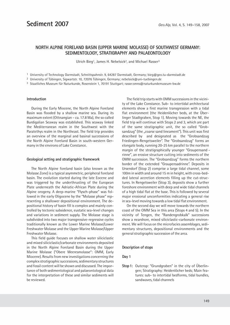
The field trip starts with OMM successions in the vicini-ty of the Lake Constance. Sub- to intertidal architecturalelements show a first marine transgression with a tidalflat environment (the Heidenlöcher beds, at the Über-linger Stadtgraben, Stop 1). Moving towards the NE, thefield trip will continue with Stops 2 and 3, which are partof the same stratigraphic unit, the so called “Grob-sandzug” (the „coarse sand lineament“). This unit was firstdescribed by and designated as the “GrobsandzugFriedingen-Rengetsweiler”. The “Grobsandzug” forms anelongate body, running 20-25 km parallel to the northernmargin of the stratigraphically younger “Graupensand -rinne”, an erosive structure cutting into sediments of theOMM succession. The “Grobsandzug” forms the northernborder of the extended “Graupensadrinne”. Deposits inUrsendorf (Stop 2) comprise a large tidal channel, some100m in width and around 15 m in height, with cross-bed-ded lateral accretion elements filling up the cut-struc-tures. In Rengetsweiler (Stop 3), deposits show a furtherforeshore environment with deep and wide tidal channelsof a high tidal flat at the base. This is followed by severalmajor erosional unconformities indicating a general risein sea-level moving towards a low tidal flat environment.
On the second day we will move towards the northerncoast of the OMM Sea in this area (Stops 4 and 5). In thevicinity of Tengen, the “Randengrobkalk” successionsshow a nearshore, mixed siliciclastic-carbonate environ-ment. We will focus on the microfacies assemblages, sedi-mentary structures, depositional environments and thegeneral stratigraphic succession of the area.
DDeessccrriippttiioonn ooff ssttooppss
DDaayy 11
SSttoopp 11:: Outcrop: “Grundgraben” in the city of Überlin-gen; Stratigraphy: Heidenlöcher beds; Main fea-tures: sub- to intertidal bedforms, tidal bundles,sandwaves, tidal channels
Geo.Alp, Vol. 4, 2007150
Fig. 1: Sketch map with excursion stops and a schematic stratigraphic NW-SE cross-section of the SW German part of the North Alpine Foreland Basin.
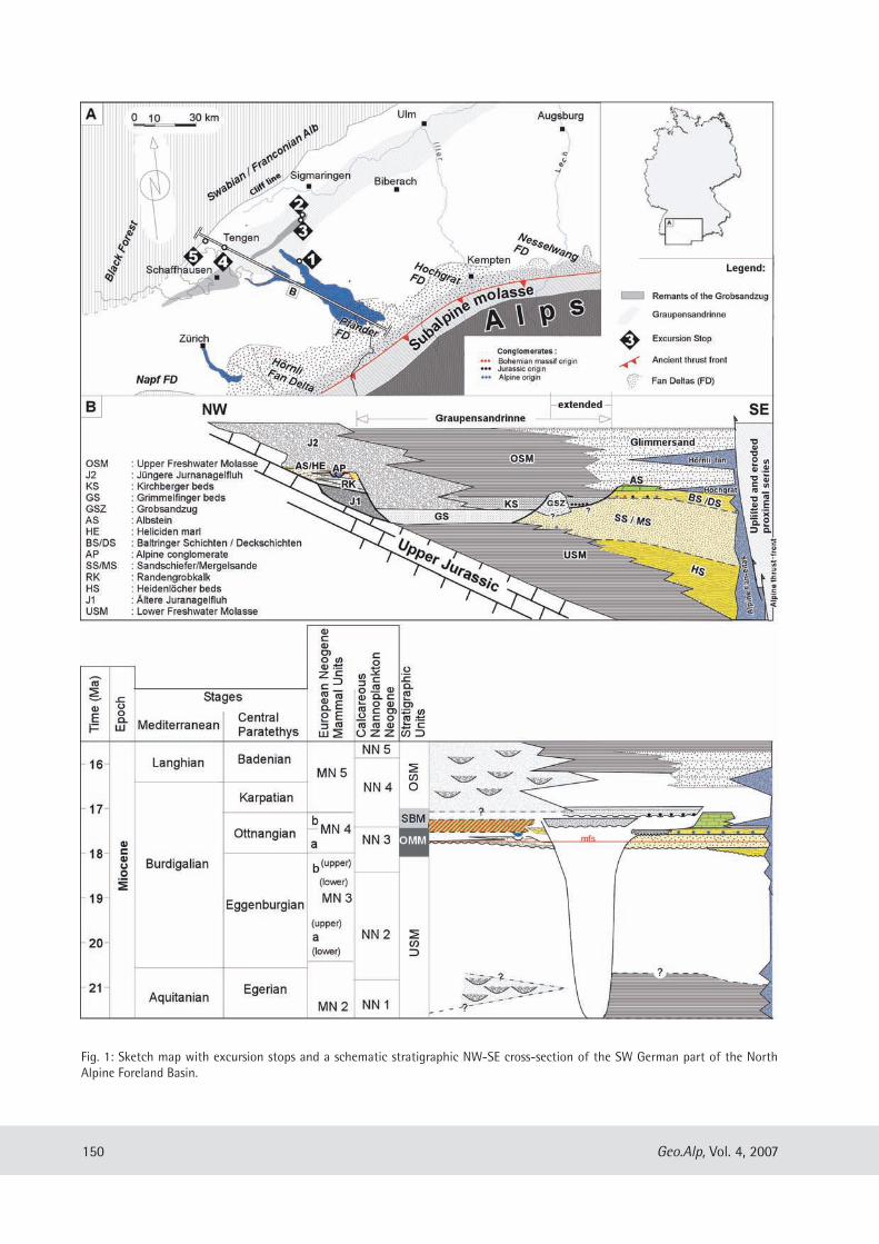
The excellent outcrops in the “Stadtgraben” (the citymoat) are described by Winder (1983) and Zweigel (1998) .The succession is composed of sandy to shaley-sandy tidaldeposits of mainly subtidal and a few of inter-tidal origin.Different types of sand flat and mixed mud-sandflat de-posits can be distinguished as well as different kinds of tidalchannels. Zweigel (1998) also recognized two 8 to 10mthick shallowing upward cycles separated by a distincttransgressive surface which can be traced across the entireoutcrop. The lower sequence contains very well-preservedneap-spring tidal bundles with sigmoidal foreset laminaeand double clay drapes (see e.g. Visser 1980).
SSttoopp 22:: Outcrop: Ursendorf; Stratigraphy: Grobsandzug;Main features: Large scale cut and fill structure ofsome 100m in length and some 10 m height
The sandpit near Ursendorf shows four depositionalunits. The lowermost unit is characterized by silt and finesand; no sedimentary structures are observed. Above anerosional unconformity, laterally aligned lenticular bed-ding shows a heterolithic facies composed of coarse sandsforming current and wave ripples. Ripple troughs are filledwith fine sand. This results in wavy and irregular bedding,suggesting frequent changes in current velocity aggrading
Geo.Alp, Vol. 4, 2007 151
Fig. 2: OMM succession in the Überlingen “Stadtgraben” (Zweigel 1998).
Geo.Alp, Vol. 4, 2007152
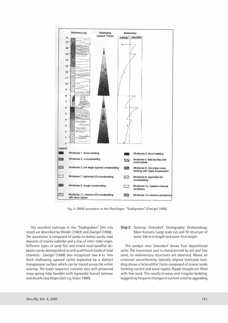
Fig. 3: Outcop panels showing different depositional units. Unit C shows prominent tangential foresets. Grain size decreases towardsthe S indicating a filling of the cut structure from the NNE in a multi storey fashion.
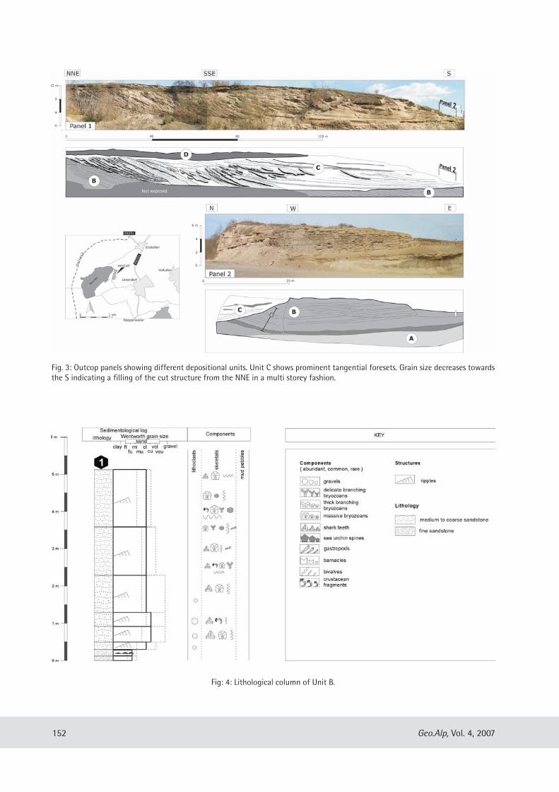
Fig: 4: Lithological column of Unit B.
Geo.Alp, Vol. 4, 2007 153
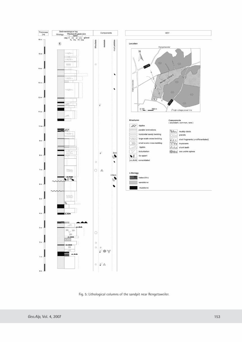
Fig. 5: Lithological columns of the sandpit near Rengetsweiler.
in the veritcal. Current velocity, however, must alwayshave been above the threshold for sand moving as a bed-load component. Moreover, this unit is characterized byshallow troughs cutting into the ripple bed horizons. Post-depositional cementation with preferential fluid pathwaysin the coarse grained sand fraction cemented the ripplebeds and show typical weathering in the medium sand in-terbeds. The ripple bedded succession shows a general de-crease in ripple wavelength and amplitude towards the topof the succession indicating a gradual decrease in hydro-dynamic energy and thus a rise in sea-level.
A prominent concave erosional discontinuity, which istraceable throughout the whole outcrop, separates thelower unit 2 from the unit above. This Unit 3 is character-ized by sigmoidal to tangential foresets of coarse sand withintercalated fine sand troughs showing also internal crossbedding. The whole structure progrades towards the southand fills the undercut channel in a multi-storey fashion dis-played by various reactivation and erosional surfaces.
The Ursendorf locality is historically well known for itsbryozoan fauna, but also for its molluscs and shark teeths.Both Miller (1875, 1877) and Engel (1908) mentioned theUrsendorf locality which includes a rich bryozoan fauna aswell as six echinoid species including a sea-urchin namedafter the locality (Spatangus ursendorfensis). These fossil-iferous parts are, unfortunately, no longer accessible. Re-cently, Höltke (accepted) described 11 bivalve and 9 gas-tropod genera from museum collection material. The gas-tropods are only preserved as internal moulds. Interesting-ly, turritelline gastropods, which can be abundant at somelocalities in the OMM (e.g. Turritella: Ermingen and North-ern Lake Constance area), are absent in Ursendorf. Recentinvestigations by the authors show that shark teeth domi-nate the fossil content together with massive, nodularbryozoans and bivalves. Among the bivalves, only calciticshelled taxa, such as ostreids and pectinids, occur withtheir shells preserved. The basal, silty to fine-sandy sedi-ments without structures lack macrofossils. The overlyingunit reveals a general trend with shark-teeth becomingless abundant upsection, with a concurrent increase in themassive, nodular bryozoan colonies.
SSttoopp 33:: Outcrop: Rengetsweiler: Sandpit “Steidle GmbH”;Stratigraphy: Grobsandzug, unknown stratigra -phic position; Main features: tidal laminates, tidalcreek and tidal flats
The succession starts with a muddy tidal flat which isdrained by most probably meandering tidal creeks. Tidalchannels are floored with rip apart sandy lithoclasts up to50 cm in size derived from the coast. Towards the top ofthe succession, the tidal flat deposits change several timesfrom flaser bedded indicating high tidal flats to ripple bed-ded indicating lower tidal flats. These are each separated
by major erosional unconformities designated by lag com-posed of quartz, pebbles and shark teeth overlying thebasal unconformity.
The deposition of tidal rhythmites (tidal flat deposits)requires a morphological restricted environment and highconcentrations of suspended sediment resulting from ac-tive wave-induced resuspension in an outer bay or off-shore environment. A protected environment is necessaryto limit erosional processes resulting from wave action orhighly energetic tidal currents. The wide range of beddingtypes that express the tidal rhythmites are a reflection ofhighly variable hydrodynamic conditions. These vary from1) weak energy with suspension load transport and set-tling which result in planar bedding to 2) more energeticdynamic conditions with bedload transport and erosionalprocesses resulting in climbing ripple bedding and flaser-and wavy bedding.
The observed high turbidity can be related to offshorewave dynamics. High turbidity may also occur within flu-vial-tidal settings such as an estuarine environment withhigh river discharge. The top of the succession is dominat-ed by large-scale dunes prograding towards the South-west. Within the foresets, the cyclic tidal current reversalshave resulted in the generation of “tidal bundles” enclosedbetween planes characterized by erosion or non-erosion.Non-erosional surfaces represent the still-stand phase ofdune migration during the subordinate tide. “Pauseplanes” may be draped by one or two thin mud laminaerepresenting slack water conditions. Usually most of theslack water drape deposited on the ripple front directlyafter the dominant tide is eroded. Only a mud drape de-posited after the subordinated tide is preserved. However,medium-scale dunes in the sand pit show “mud layer cou-plets” indicating low flood current velocity, which is notstrong enough to erode the sediment.
During measuring and sampling of the sections by theauthors, the outcrop was sieved for fossil material. The lo-cality is well-known for its fossil shark teeth, which alsodominated our samples. The largest specimens (up to 55mm) and highest abundance of shark teeth was foundwithin a rubble layer, which suggest hydrodynamically induced sorting within a lag deposit. Other fossils includecrustacean fragments, massive and delicate branchingbryozoans, fragile echinoid spines and other echinoidfragments as well as bivalves and a few gastropods. Pec-tinids and ostreids dominate among the bivalves. General-ly, the abundance of fossils appear to decrease upsection.The large scale dunes at the top of the succession com-pletely lack fossils.
DDaayy 22
The Randengrobkalk and associated sediments in theHegau region of southern Baden-Württemberg.
Geo.Alp, Vol. 4, 2007154
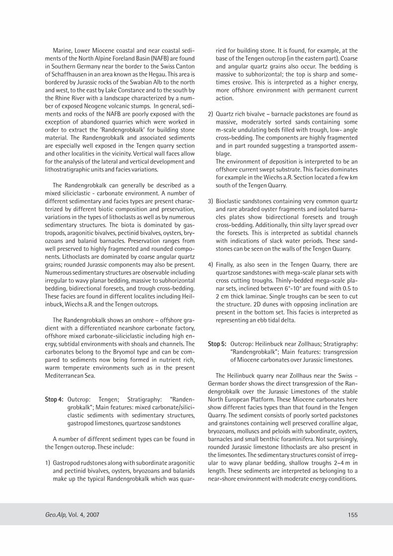
Marine, Lower Miocene coastal and near coastal sedi-ments of the North Alpine Foreland Basin (NAFB) are foundin Southern Germany near the border to the Swiss Cantonof Schaffhausen in an area known as the Hegau. This area isbordered by Jurassic rocks of the Swabian Alb to the northand west, to the east by Lake Constance and to the south bythe Rhine River with a landscape characterized by a num-ber of exposed Neogene volcanic stumps. In general, sedi-ments and rocks of the NAFB are poorly exposed with theexception of abandoned quarries which were worked inorder to extract the ‘Randengrobkalk’ for building stonematerial. The Randengrobkalk and associated sedimentsare especially well exposed in the Tengen quarry sectionand other localities in the vicinity. Vertical wall faces allowfor the analysis of the lateral and vertical development andlithostratigraphic units and facies variations.
The Randengrobkalk can generally be described as amixed siliciclastic - carbonate environment. A number ofdifferent sedimentary and facies types are present charac-terized by different biotic composition and preservation,variations in the types of lithoclasts as well as by numeroussedimentary structures. The biota is dominated by gas-tropods, aragonitic bivalves, pectinid bivalves, oysters, bry-ozoans and balanid barnacles. Preservation ranges fromwell preserved to highly fragmented and rounded compo-nents. Lithoclasts are dominated by coarse angular quartzgrains; rounded Jurassic components may also be present.Numerous sedimentary structures are observable includingirregular to wavy planar bedding, massive to subhorizontalbedding, bidirectional foresets, and trough cross-bedding.These facies are found in different localites including Heil-inbuck, Wiechs a.R. and the Tengen outcrops.
The Randengrobkalk shows an onshore – offshore gra-dient with a differentiated nearshore carbonate factory,offshore mixed carbonate-siliciclastic including high en-ergy, subtidal environments with shoals and channels. Thecarbonates belong to the Bryomol type and can be com-pared to sediments now being formed in nutrient rich,warm temperate environments such as in the presentMediterranean Sea.
SSttoopp 44:: Outcrop: Tengen; Stratigraphy: “Randen-grobkalk”; Main features: mixed carbonate/silici-clastic sediments with sedimentary structures,gastropod limestones, quartzose sandstones
A number of different sediment types can be found inthe Tengen outcrop. These include:
1) Gastropod rudstones along with subordinate aragoniticand pectinid bivalves, oysters, bryozoans and balanidsmake up the typical Randengrobkalk which was quar-
ried for building stone. It is found, for example, at thebase of the Tengen outcrop (in the eastern part). Coarseand angular quartz grains also occur. The bedding ismassive to subhorizontal; the top is sharp and some-times erosive. This is interpreted as a higher energy,more offshore environment with permanent currentaction.
2) Quartz rich bivalve – barnacle packstones are found asmassive, moderately sorted sands containing somem-scale undulating beds filled with trough, low- anglecross-bedding. The components are highly fragmentedand in part rounded suggesting a transported assem-blage.The environment of deposition is interpreted to be anoffshore current swept substrate. This facies dominatesfor example in the Wiechs a.R. Section located a few kmsouth of the Tengen Quarry.
3) Bioclastic sandstones containing very common quartzand rare abraded oyster fragments and isolated barna-cles plates show bidirectional foresets and troughcross-bedding. Additionally, thin silty layer spread overthe foresets. This is interpreted as subtidal channelswith indications of slack water periods. These sand-stones can be seen on the walls of the Tengen Quarry.
4) Finally, as also seen in the Tengen Quarry, there arequartzose sandstones with mega-scale planar sets withcross cutting troughs. Thinly-bedded mega-scale pla-nar sets, inclined between 6°-10° are found with 0.5 to2 cm thick laminae. Single troughs can be seen to cutthe structure. 2D dunes with opposing inclination arepresent in the bottom set. This facies is interpreted asrepresenting an ebb tidal delta.
SSttoopp 55:: Outcrop: Heilinbuck near Zollhaus; Stratigraphy:“Randengrobkalk”; Main features: transgressionof Miocene carbonates over Jurassic limestones.
The Heilinbuck quarry near Zollhaus near the Swiss –German border shows the direct transgression of the Ran-dengrobkalk over the Jurassic Limestones of the stableNorth European Platform. These Miocene carbonates hereshow different facies types than that found in the TengenQuarry. The sediment consists of poorly sorted packstonesand grainstones containing well preserved coralline algae,bryozoans, molluscs and peloids with subordinate, oysters,barnacles and small benthic foraminifera. Not surprisingly,rounded Jurassic limestone lithoclasts are also present inthe limesontes. The sedimentary structures consist of irreg-ular to wavy planar bedding, shallow troughs 2–4 m inlength. These sediments are interpreted as belonging to anear-shore environment with moderate energy conditions.
Geo.Alp, Vol. 4, 2007 155
RReeffeerreenncceess
Büchi, U. P. 4 Hofmann, F. (1960): Die Sedimentationsver-hältnisse zur Zeit der Muschelsandsteine und Grobkalkeim Gebiet des Beckennordrandes der Oberen Meeres-molasse zwischen Aarau und Schaffhausen. – Bull.Vereinigung Schweizerischer Petroleum-Geologen und-Ingenieure, 27: 11-22.
Engel, T. (1908): Geognostischer Wegweiser durch Würt-temberg. – 645 S., Stuttgart (Schweizerbart).
Gutmann, S. (1910): Gliederung der Molasse und Tektonikdes östlichen Hegaus. – Mitt. bad. geol. Landesanst., 6:469–514.
Haus, H. A. (1951): Zur paläogeographischen Entwicklung desMolassetroges im Bodenseegebiet während des mittlerenMiozäns. –Mitt. Bad. geol. Landesanst., 1950: 48-66.
Höltke, O. (accepted): Die Molluskenfauna der OberenMeeresmolasse von Ermingen und Ursendorf. –Stuttgarter Beitr. Naturk. Serie B.
Miller, K. (1875): Die Bryozoenfauna von Ursendorf. –Jahresh. Ver. Vaterländ. Naturk., 31: 82–84.
Miller, K. (1877): Das Molassemeer in der Bodenseegegend.– Schriften des Vereins für die Geschichte des Bodensees und seiner Umgebung, 7.
Rutte, E. (1952): Grobsand und Muschelsandstein in dermiozänen Meeresmolasse des nordwestlichen Boden -
Geo.Alp, Vol. 4, 2007156
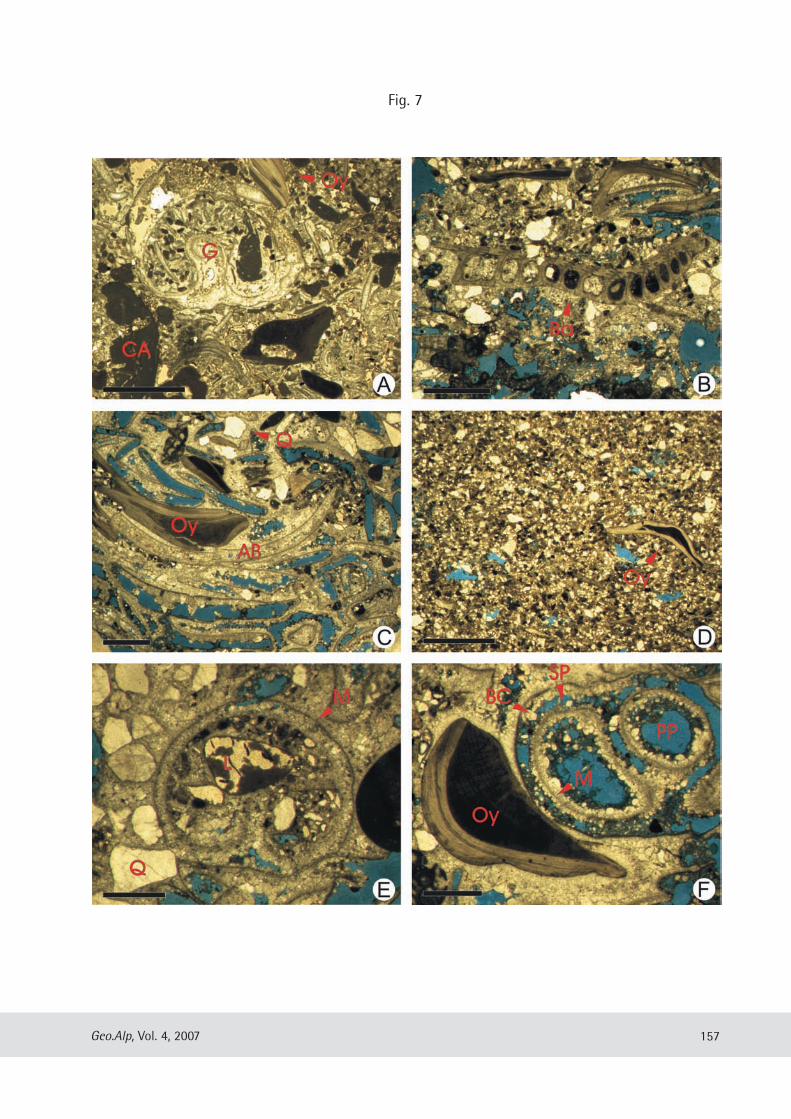
Fig. 7: Examples of different microfacies, components and diagenesis. Pore space is coloured blue.
A) Pack- to grainstone dominated by coralline algae (CA) and mollusc remains with gastropods (G) and oysters (Oy). Note the finersediments within the body cavity of the gastropod seen here in cross section. Many fragments of former aragonitic mollusc shell re-mains bivalves are also present and characterized by micritized rims. Locality: Heilinbuck, TS HB-Basis, Scale bar = 2 mm.B) Quartz rich, bivalve – barnacle packstone. A single large balanid barnacle plate (Ba) shows typical canals and tree-like structuresin cross section. Locality: Tengen, TS: 2 Scale bar = 2 mm.C) Grainstone with rounded oyster fragments (Oy) , aragonitic bivalve remains (AB) and subangular to subrounded quartz grains (Q).Locality: Tengen, TS: 7, Scale bar = 2 mm.D) Bioclastic sandstones containing very common quartz and rare fragmented and abraded oyster fragments. Locality: Tengen, TS: 6,Scale bar = 2 mm.E) A cross section through a gastropod surrounded and infilled by coarse angular to subrounded quartz grains (Q). A lithoclasts (L) isalso present within the shell. The micritized gastropod shell (M) has been completely replaced by sparite. Locality: Tengen, TS: 5,Scale bar = 1 mm.F) Detail showing rounded, fragmented oyster fragment and different types of pore space. A gastropod shows primary pore spacewithin the shell (PP). The shell itself has been micritized (M), dissolved, and only partially replaced by blocky sparite cement (BC) ,resulting in common secondary pore space (SP). Locality: Tengen, TS: 7, Scale bar = 1 mm.
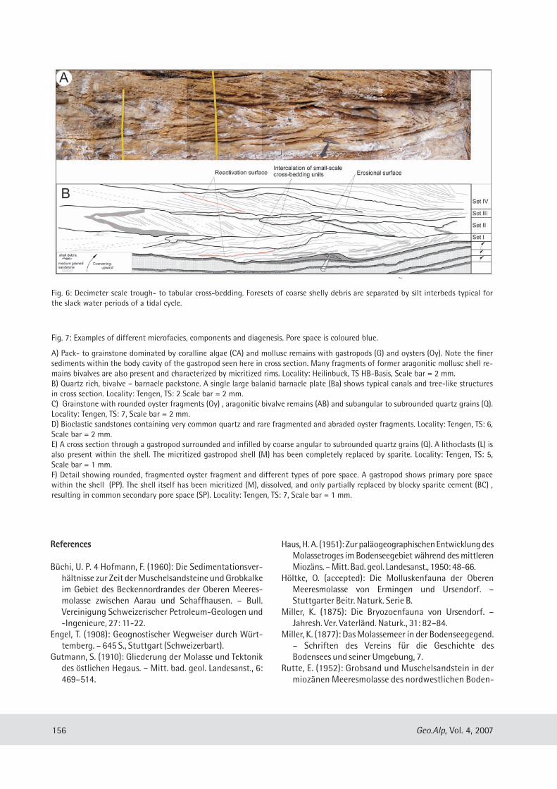
Fig. 6: Decimeter scale trough- to tabular cross-bedding. Foresets of coarse shelly debris are separated by silt interbeds typical forthe slack water periods of a tidal cycle.
Geo.Alp, Vol. 4, 2007 157
Fig. 7
seegebietes. – N. Jb. Geol. Paläont. Abh. Mh.:295–304.
Teike, M. (1921): Die Molasse im Linzgau und ihre Tektonik.– Unpubl. Phd Thesis.
Teike, M. (1923): Die Molasse im bad.-württ. Grenzgebietsüdlich von Sigmaringen. –Mitt. bad. geol. Landesanst.,9: 408–426.
Visser, M. J. (1980): Neap-spring cycles reflected inHolocene subtidal large-scale bedform deposits: A pre-liminary note. – Geology, 8: 543–456.
Werner, J. (1966): Ergebnisse der Auswertung von Flach-bohrungen im Bereich des Gobsandzuges der Oberen
Meeresmolasse (Gebiet Stockach-Pfullendorf). – Jber.Mitt. oberrh. geol. Ver., N. F. 48: 105–120.
Winder, H. (1983): Untersuchung der Fazies der OberenMeeresmolasse nördlich des Überlinger Sees (Bo-densee). – Unpublished Diploma thesis, University ofTübingen.
Zweigel, J. (1998): Reservoir analogue modelling of sandytidal sediments, Upper Marine Molasse, SW Germany,Alpine foreland basin. – In: Mascle A., PuigdefàbregasC., Luterbacher H.-P. Fernàndez M. (eds.): CenozoicForeland Basins of Western Europe. Geological SocietySpecial Publication, 134, 325–337.