
NavalStation
Ingleside
Naval Air StationCorpus Christi
Naval Air Station Corpus Christi (Auxiliary Landing Field Cabaniss)
Naval Station Ingleside (Hope Disposal)
Naval Air Station Corpus Christi (Waldron Auxiliary Landing Field)
Naval Station Ingleside
Spears Lk
Tule Lk
RinconByu
LagunaLarga
Oso Bay
Oso Bay
Lake
Oso Crk
Gulf of Mexico
Laguna Larga
LagunaLarga
Gulf of Mexico
Laguna Madre
PortBay
Laguna Madre
Laguna Madre
Nueces Bay
Oso Bay
Tule Lake Chnnl
Tule Lake Chnnl
Chiltipin Crk
Peters Swale
Hondo Crk
Petronila Crk
Stream
Pet e rs Sw
ale
Stream
Dra
inag
e Cnl
Gum Holw
S So
ovil l
e Dra
inag
e Ditc
h
Stream
Stream
Stream
Stream
Stream Stream
Stream
West Oso C rk
Wes t Oso Crk
Stre
am
Stream
Stream
Stream
Airport Drainageway
Stream
Stre a m
Stream
Stre
am
Railroad
Texas Mexican Rlwy
Texa
s
M
exican Rlwy
Mis
souri P
aci
fic R
R
Railr
oad
Railr
oad
Texa
s
Mexi
can R
lwy
Railroad
Railroad
Missouri
Pacif ic RR
Mis
souri
Pacif
ic R
R
Ra
ilroad
37
37
37
37
37
37
37
37
3737
3737
37
Co Rd 48
Co Rd 14
FM 2
29
2
Co
Rd
37
Bock
holt R
d
Co R
d 35
Co R
d 3
3
Co R
d 7
7
Co R
d 3
1
Co R
d 5
7
Co Rd 36
Co Rd 52
McGloin Rd
Co R
d 6
7
Co Rd 66
Co Rd 74
Co R
d 2
9
S P
adre
Isl
and D
r
Park
Roa
d 22
FM 1
069
N P
adre
Island D
r
FM 2
986
FM 6
31
FM
1074
Co R
d 6
3
Ric
hard
son R
d
FM
796
Labor Camp Exd
Co Rd 78
Co Rd 10
Co R
d 6
7
Co Rd 10
Co R
d 4
3
Co Rd 8
FM 8
93
4th St
FM 1
88
9
FM 2
725
Sodvi
lle R
d
FM
136
Co R
d 5
5
Co R
d 5
1
Co Rd 12
FM 665
Co R
d 7
3
Cr
23
67
Co Rd 24
Co R
d 7
3B
Co Rd 38
Co R
d 6
1
Co Rd 50
Co R
d 6
5
Co Rd 12
McK
am
ey
Rd
Cr 2
28
9
FM 631
S Main St
Sendero and Patrol Rd
S Hwy 7
7
Cr
25
67
McC
am
pbell
Rd
FM 1944
Cr 3561
Cr 1510 Cr 3579
Pvt R
d 8
7A
Cr 3677
Cr 3865
FM 6
31
FM 70
Cr 1694
Cr 1458
Cr 3861
FM 893
Kenny Ln
FM 3
284
Co R
d 7
3
Co R
d 7
7
Co Rd 34
Co Rd 18
FM 3
38
6
Wa
re R d
FM 3512
Co Rd 72
Cr
24
67
Rand M
org
an R
d
FM 43
Co Rd 26
Co Rd 28
Co Rd 44
FM 1
69
4
Co Rd 6
Co Rd 36
Co Rd 22
Cr 1726
Co Rd 66A
Co R
d 5
9
Co Rd 30
Co R
d 6
9
Co R
d 9
7
Co Rd 54
Co Rd 12
Cr 1568
E Main Ave
Co Rd 30
Co R
d 6
9
Co R
d 7
5
Co R
d 7
5
Co R
d 7
3
Co R
d 7
5
Co Rd 6
Co R
d 5
7
Co Rd 14A
Co Rd 20A
Co R
d 4
7
Co
Rd
51
Co R
d 5
3
Co Rd 1472
Co Rd 1470
Co R
d 7
9
Co Rd 76
Co R
d 1
96
9
Co Rd 42
Co R
d 7
7
Co R
d 6
1
Co Rd 42
Co Rd 80
Co R
d 2
3
Co
Rd 8
1
Co R
d 5
7
Co R
d 5
1
FM 2512
FM 8
92
Co Rd 16
Co R
d 6
5
Co Rd 18
Co Rd 20 Co Rd 20
Co R
d 6
9
Co R
d 6
3
Cr
1906
Co R
d 6
3
Co Rd 46
Co R
d 4
9
Co R
d 6
7
Co R
d 6
9
FM 7
63
FM 2826
Chapm
an R
anch
Rd
Co R
d 5
1
Co R
d 4
5
Co Rd 34
Co Rd 26
S C
larkw
ood R
d
Agnes
Co Rd 22
Co Rd 28
Co Rd 34
Co Rd 36
Co R
d 6
1
FM 6
65
Co Rd 20
Co Rd 26
Voss
Ave
Co Rd 34
Co R
d 3
3
Co R
d 7
5
S Staples St
Co Rd 18
Co R
d 5
9
Co R
d 5
7
Co Rd 5
7
Joe Fulton Corridor
Be
auvaisDr
Pinson
Dr
Compton Rd
Agnes St
Bratton Rd
Glenoak Dr
Emil St
Yorktown Blvd
Bear
Ln
Ft
Worth
St
McArdle Rd
CanteraTrl
Spanish
Trl
Pot
hLn
Up River Rd
1st St
Vict
oria
Par
k Dr
Walla
ce A
ve
I - 37
Suntid
e R
d
Aye
rs S
t S Padre IslandDr
Lipan St
Sandra Ln
I - 37
Dal
yD
r
Wal
dro
n Rd
S Padre Island Dr
WebbSt
Old
Bro
wns
ville
Rd
FM 2
4
Graford Pl
45
th S
t
Rehf
eld
Rd
Saratoga Blvd
Hearn
Rd
Web
erRd
Lens Dr
Ss 407 W
Ss 407 W
Mac
arth
urSt
Oso P
kwy
Sta
t eH
wy
Park
Rd
22
E
St
4th
St
Ss 407W
Oriole
St
LamontSt
Cyn
thia
St
Wild
cat
Dr
Cr 2004
Ros
cher
Rd
Sta
rk R
d
Northwest BlvdNorthwest Blvd
MooreAve
1st St
del Oso
Rd
Hearn Rd
Oso Pkw
y
J F Kennedy Cswy
Ocean Dr
Ocean Dr
Partrid
ge
Rd
Up River Rd
W 4th St
Hopkins Rd
TimbergateDr
el Monte St
Ss 544 E
BroadwayBlvd
9th
St
Graham Rd
Gre
enw
ood D
r
Rod
dFi
eld R
d
Texa
n
Trl
TribbleLn
Service Rd
McK
inzi
e R
d
WooldridgeRd
G
ree ly Dr
Starli te Ln R
oad
N
Sunset D
r
SpohnDr
44
thSt
PurdueRd
Oso Pkw
y
Sun B elt
Dr
Pr 22 N
Golla
Dr
Har
t
Rd
Caribbean Dr
Co Rd 54
Co Rd 54
Co Rd 34
Lindgre
en R
d
Om
aha
Dr
CorsicaRd
Bush
St
Panama Dr
Up River Rd
Ceda
r Dr
JesterSt
Oak
Par
kAve
P
rincess Dr
Mc Norton Rd
Cim
arro
n Blv
d
Junio
r Beck D
r
Haven Dr
Corn
Pro
duct
s R
d
Lang Rd
Co R
d 6
9
Saratoga Blvd
Airport
Rd
SloughRd
Riv
er
Ln
Holly Rd Dunbarton Oak Dr
Pete
rson
Allis
on R
d
Etienn
eD
r
Barlo
w Trl
Sou
thba
yDr
Frio St
Leopard St
Leopard St
Can
twel
l L
n
Clearview Dr
Tim
onBlvd
Ramfield Rd
Cal
licoa
tte
Rd
Flato
Rd
Navigation Blvd
Ih 37 N
Holly Rd
Co R
d 4
1
Flou
r Blu
ff D
r
Flou
r Blu
ff D
r
Vio
let
Rd
S P
adre
Isla
nd D
r
Aqu
arius
St
Rhew
Rd
Dove
Ln
Pr 22 N
Silverb e r r y
Airlin
e R
d
Sess
ions
Rd
D
St
Agnes St
Co R
d 7
5
Riv
er
Trail
Dr
N P
adre Is land D
r
Wagon
T rl
Navi
gation B
lvd
Los
Rob
les
Dr
Deb
ra L
n
Tktr A
Ware
Rd
Joe
Mireur
Rd
Akins
Dr
Main
Dr
Market St
FM 624
BuddyGanem
Dr
Sta
ple
s St
BostonDr
Riv
er Ln
Gre
enwoo
dDr
Mallard Dr
Here
ford
Rd
Pau
l Jon
esAve
Renf
row
Rd
Leopard St
Leopard St
35
4444
361
35
286
358
357
234
286
286
4444
44 44
286
286
286
358
286
358
358
44
4444
361
35
361
35 35
358
358
358
544
358
358
358
286
358
357
357
544
286
44
358
407
544
361
407
35
357
77
77
181
77
77
181
77
77
77
77
77
181
181
181
77
18177
181
7777
181
77
181
77
77
77
77
181
181
181
181
77
77
181
77
77
181
KLEBERG 273
NUECES 355
SAN PATRICIO 409
NUECES 355
ARA
NSA
S 007
SAN
PATRICIO
409
Taft Southwest 71696
TierraGrande 72952
North San Pedro 52404
Edroy22768
La Paloma-Lost Creek 41422
TierraVerde72954
Doyle 21283
Ingleside on the Bay 36020
Taft 71684
Ingleside 36008
Petronila 57056
Robstown 62600
Odem 53376
Portland 58904
CorpusChristi17000
Gregory 31064
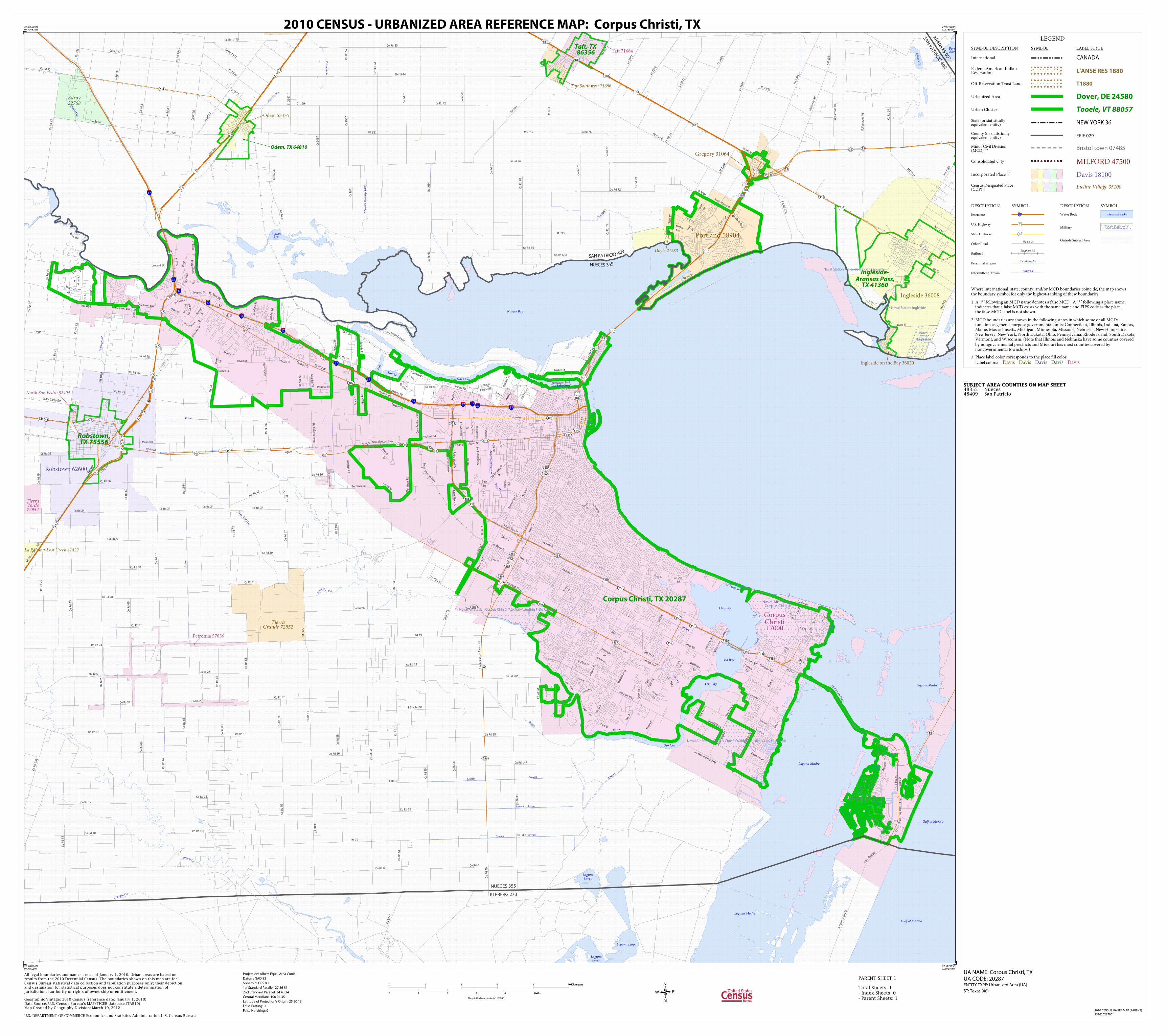
Corpus Christi, TX 20287
Taft, TX86356
Ingleside-Aransas Pass,
TX 41360
Robstown,TX 75556
Odem, TX 64810
LEGEND
SYMBOL DESCRIPTION SYMBOL LABEL STYLE
International CANADA
Federal American IndianReservation L'ANSE RES 1880
Off-Reservation Trust Land T1880
Urbanized Area Dover, DE 24580
Urban Cluster Tooele, VT 88057
State (or statisticallyequivalent entity) NEW YORK 36
County (or statisticallyequivalent entity) ERIE 029
Minor Civil Division(MCD)1,2 Bristol town 07485
Consolidated City MILFORD 47500
Incorporated Place 1,3 Davis 18100
Census Designated Place(CDP) 3 Incline Village 35100
DESCRIPTION SYMBOL DESCRIPTION SYMBOL
Interstate 3
U.S. Highway 2
State Highway 4
Other RoadMarsh Ln
RailroadSouthern RR
Perennial StreamTumbling Cr
Intermittent StreamPiney Cr
Water Body Pleasant Lake
Military Fort Belvoir
Outside Subject Area
Where international, state, county, and/or MCD boundaries coincide, the map showsthe boundary symbol for only the highest-ranking of these boundaries.
1 A ' ° ' following an MCD name denotes a false MCD. A ' ° ' following a place name indicates that a false MCD exists with the same name and FIPS code as the place; the false MCD label is not shown.
2 MCD boundaries are shown in the following states in which some or all MCDs function as general-purpose governmental units: Connecticut, Illinois, Indiana, Kansas, Maine, Massachusetts, Michigan, Minnesota, Missouri, Nebraska, New Hampshire, New Jersey, New York, North Dakota, Ohio, Pennsylvania, Rhode Island, South Dakota, Vermont, and Wisconsin. (Note that Illinois and Nebraska have some counties covered by nongovernmental precincts and Missouri has most counties covered by nongovernmental townships.)
3 Place label color corresponds to the place fill color.
Label colors: Davis Davis Davis Davis Davis
SUBJECT AREA COUNTIES ON MAP SHEET 48355 Nueces48409 San Patricio
27.996001N97.704876W
27.984908N97.178505W
27.517915N97.192194W
27.528961N97.71608W
All legal boundaries and names are as of January 1, 2010. Urban areas are based onresults from the 2010 Decennial Census. The boundaries shown on this map are forCensus Bureau statistical data collection and tabulation purposes only; their depictionand designation for statistical purposes does not constitute a determination ofjurisdictional authority or rights of ownership or entitlement.
U.S. DEPARTMENT OF COMMERCE Economics and Statistics Administration U.S. Census Bureau
Geographic Vintage: 2010 Census (reference date: January 1, 2010)Data Source: U.S. Census Bureau's MAF/TIGER database (TAB10)Map Created by Geography Division: March 10, 2012
ENTITY TYPE: Urbanized Area (UA)
UA NAME: Corpus Christi, TXUA CODE: 20287
Projection: Albers Equal Area Conic
Datum: NAD 83
Spheroid: GRS 80
1st Standard Parallel: 27 36 51
2nd Standard Parallel: 34 43 24
Central Meridian: -100 04 35
Latitude of Projection's Origin: 25 50 13
False Easting: 0
False Northing: 0
Total Sheets: 1- Index Sheets: 0- Parent Sheets: 1
ST: Texas (48)
0 2 4 6 8 10 Kilometers10 Kilometers
0 1 2 3 4 5 Miles5 Miles
The plotted map scale is 1:70900
2010 CENSUS - URBANIZED AREA REFERENCE MAP: Corpus Christi, TX
2010 CENSUS UA REF MAP (PARENT)
231020287001
PARENT SHEET 1


