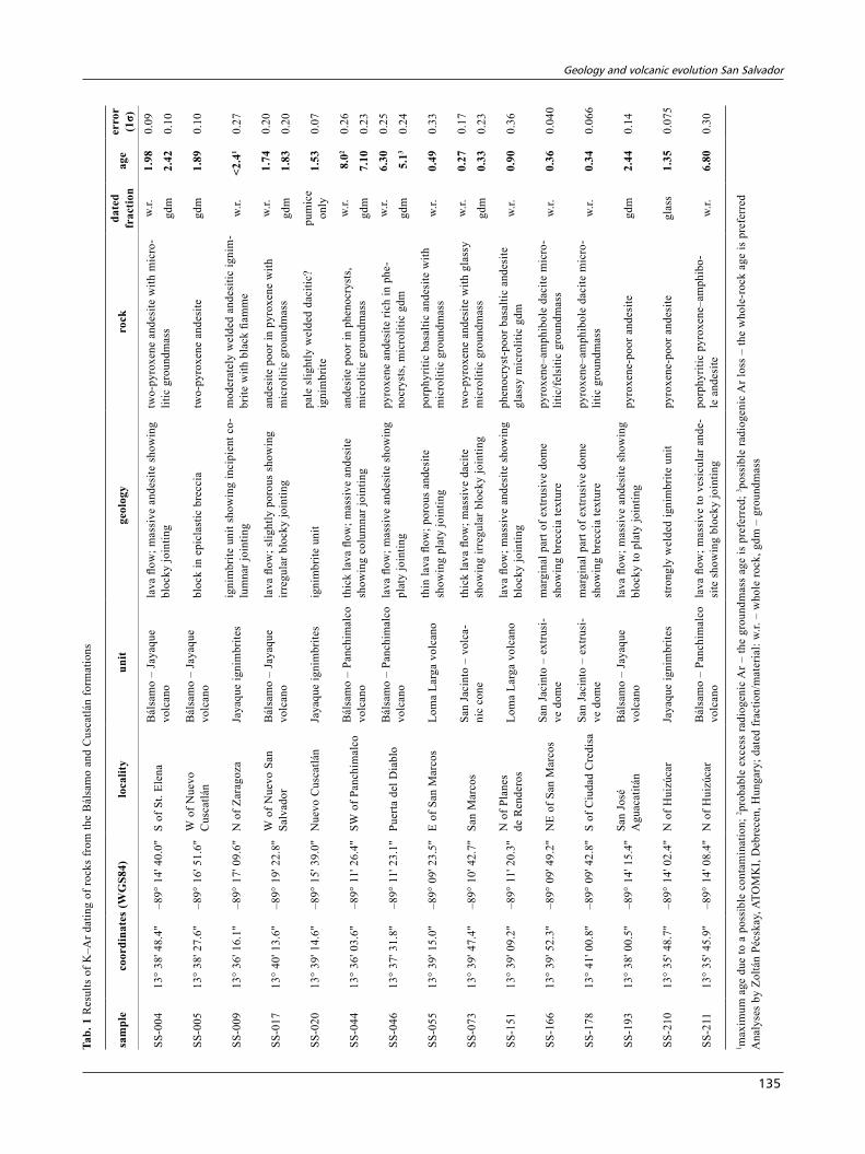
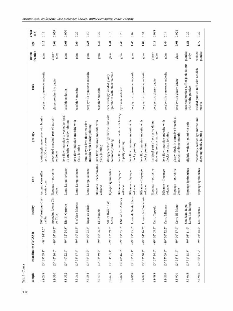
www.jgeosci.org Journal of Geosciences, 56 (2011), 105–140 DOI: 10.3190/jgeosci.088 Original paper Geology and volcanic evolution in the southern part of the San Salvador Metropolitan Area Jaroslav LEXA 1* , Jiří ŠEBESTA 2 , José Alexander CHAVEZ 3,4 , Walter HERNÁNDEZ 5 , Zoltán PéCSKAY 6 1 Geological Institute SAS, Dúbravská cesta 9, 845 05 Bratislava, Slovakia; [email protected]2 Czech Geological Survey, Klárov 3, 118 21 Prague 1, Czech Republic 3 Oficina de Planificación del Área Metropolitana de San Salvador (OPAMSS), Diagonal San Carlos 15 Avenida Norte y 25 Calle Poniente Col Layco, San Salvador, El Salvador 4 Czech Technical University in Prague, Faculty of Civil Engineering, Department of Geotechnics, Thákurova 7, 166 29 Prague 6, Czech Republic 5 Servicio Nacional de Estudios Territoriales,Avenida Las Mercedes, San Salvador, El Salvador 6 Institute of Nuclear Research, Hungarian Academy of Sciences, H-4001 Debrecen, P.O. Box 51, Hungary * Corresponding author We have carried out geological studies including mapping at the scale 1 : 50 000 in the southern part of the San Salvador Metropolitan Area to support urban planning and natural hazard mitigation. The study area extends over the Cordillera del Bálsamo, marginal fault system and southern part of the Central Graben between the active San Salvador volcano and Ilo- pango caldera. It represents a segment in the Central American Volcanic Front. Volcanic rocks of the Late Miocene to recent age, classified as the Bálsamo, Cuscatlán and San Salvador formations, occur in the area. Remnants of two large basaltic andesite to andesite stratovolcanoes, Panchimalco and Jayaque, represent the Bálsamo Formation. They show periclinal dips and facies zoning from lava flows and coarse epiclastic volcanic breccias of the proximal zone through epiclastic volcanic breccias/conglomerates of the medial zone to epiclastic volcanic conglomerates and sandstones of the distal zone. Their ages are 7.2–6.1 Ma and 2.6–1.5 Ma respectively. The Cuscatlán Formation comprises the Jayaque and Santo Tomás calderas, the andesitic–dacitic Ilopango and Jayaque ignimbrites (1.9–1.4 Ma) in the SW and SE parts of the area, the Ilopango andesitic volcano (1.5–0.8 Ma), the Loma Larga basaltic volcano (0.8–0.5 Ma), the Planes de Renderos caldera, the dacite–andesite San Jacinto extrusive domes and effusive cone (0.4–0.25 Ma), the San José tuff/scoria cone, the Ilopango caldera extrusive domes (0.25–0.05 Ma), the Antiguo Cuscatlán scoria cone (0.2–0.08 Ma) and older tephra deposits of the Coatepeque and Ilopango calderas exposed along marginal faults of the Central Graben. The San Salvador Formation occurs as tephra cover along the crest of the Cordillera del Bálsamo where it rests on laterites atop the Bálsamo Formation and in the Central Graben. Tephra units belong to the Coatepeque caldera (Arce and Congo), San Salvador volcano (Apopa, G1 and G2) and Ilopango caldera (Tierra Blanca 1–4) spanning 70–1 ka. Tephra units are separated by palaeosols and aeolian dusty deposits. Las amenazas naturales afectan al territorio de El Salvador en toda su extensión de manera constante. Se ha llevado a cabo un mapeo geológico en la parte Sur del Área Metropolitana de San Salvador (AMSS), asimismo se han evaluado las amenazas naturales potenciales que pueden afectar a la zona. El área de estudio se extiende sobre la Cordillera del Bálsa- mo, el sistema de fallas marginales y en la parte Sur del Graben Central entre los volcanes activos de San Salvador y la Caldera de Ilopango; representando un segmento del frente volcánico de Centro América. Las rocas volcánicas del Mi- oceno tardío hasta de edad reciente que pertenecen a las Formaciones Bálsamo, Cuscatlán y San Salvador conforman la geología del área. Los remanentes de dos extensos estratovolcanes basálticos-andesíticos hasta andesíticos, Panchimal- co y Jayaque, representan la Formación Bálsamo. Estos presentan un buzamiento periclinal y zonas con facies que van desde flujos de lava y brechas epiclásticas volcánicas gruesas de la zona proximal, brechas epiclásticas volcánicas/con- glomerados de la zona media hasta los conglomerados volcánicos epiclásticos y areniscas de la zona distal. Su edad es- tán entre los 7.2–6.1 Ma y 2.6–1.5 Ma respectivamente. La Formación Cuscatlán está representada por las Calderas Ja- yaque y Santo Tomás, las ignimbritas andesíticas/dacíticas de Ilopango y las ignimbritas de Jayaque (1.9–1.4 Ma) en la parte SO y SE del área, el volcán andesítico de Ilopango (1.5–0.8 Ma), el volcán basáltico Loma Larga (0.8–0.5 Ma), la Caldera Planes de Renderos, los domos extrusivos dacíticos/andesíticos de San Jacinto y el cono efusivo (0.4–0.25 Ma), el cono de toba/escoria de San José, los domos extrusivos de la Caldera de Ilopango (0.25–0.05 Ma), el cono de escoria de Antiguo Cuscatlán (0.2–0.08 Ma) y los depósitos de tefra inferiores de las calderas de Coatepeque e Ilopango expues- tos a lo largo de las fallas marginales del Graben Central. La Formación San Salvador está presente como una cubierta de tefra que cubre la cresta de la Cordillera del Bálsamo a lo largo de su extensión, donde yace en lateritas sobre la For- mación Bálsamo y en el Graben Central. Las unidades de tefra que pertenecen a la Caldera Coatepeque (Arce y Con- go) el Volcán de San Salvador (Apopa, G1 y G2) y la Caldera de Ilopango (Tierra Blanca 1–4) cubren un periodo de ti- empo entre 70–1 ka. Las unidades de tefra están separadas por horizontes de suelos fósiles y depósitos de polvo eólicos. Keywords: stratigraphy, lithology, palaeovolcanic reconstruction, K–Ar dating, Pliocene to Quaternary volcanic formations Received: 17 January 2011; accepted: 30 March 2011; handling editor: P. Hradecký
Transcript
www.jgeosci.org
Journal of Geosciences, 56 (2011), 105–140 DOI: 10.3190/jgeosci.088
Original paper
Geology and volcanic evolution in the southern part of the San Salvador Metropolitan Area
Jaroslav Lexa1*, Jiří Šebesta2, José alexander Chavez3,4, Walter hernÁnDez5, zoltán PéCskay6
1 Geological Institute SAS, Dúbravská cesta 9, 845 05 Bratislava, Slovakia; [email protected] Czech Geological Survey, Klárov 3, 118 21 Prague 1, Czech Republic3OficinadePlanificacióndelÁreaMetropolitanadeSanSalvador(OPAMSS),DiagonalSanCarlos15AvenidaNortey25Calle PonienteColLayco,SanSalvador,ElSalvador4CzechTechnicalUniversityinPrague,FacultyofCivilEngineering,DepartmentofGeotechnics,Thákurova7,16629Prague6, Czech Republic5ServicioNacionaldeEstudiosTerritoriales,AvenidaLasMercedes,SanSalvador,ElSalvador6InstituteofNuclearResearch,HungarianAcademyofSciences,H-4001Debrecen,P.O.Box51,Hungary*Correspondingauthor
We have carried out geological studies including mapping at the scale 1 : 50 000 in the southern part of the San Salvador Metropolitan Area to support urban planning and natural hazard mitigation. The study area extends over the Cordillera del Bálsamo, marginal fault system and southern part of the Central Graben between the active San Salvador volcano and Ilo-pango caldera. It represents a segment in the Central American Volcanic Front. Volcanic rocks of the Late Miocene to recent age, classified as the Bálsamo, Cuscatlán and San Salvador formations, occur in the area. Remnants of two large basaltic andesite to andesite stratovolcanoes, Panchimalco and Jayaque, represent the BálsamoFormation. They show periclinal dips and facies zoning from lava flows and coarse epiclastic volcanic breccias of the proximal zone through epiclastic volcanic breccias/conglomerates of the medial zone to epiclastic volcanic conglomerates and sandstones of the distal zone. Their ages are 7.2–6.1 Ma and 2.6–1.5 Ma respectively. The CuscatlánFormation comprises the Jayaque and Santo Tomás calderas, the andesitic–dacitic Ilopango and Jayaque ignimbrites (1.9–1.4 Ma) in the SW and SE parts of the area, the Ilopango andesitic volcano (1.5–0.8 Ma), the Loma Larga basaltic volcano (0.8–0.5 Ma), the Planes de Renderos caldera, the dacite–andesite San Jacinto extrusive domes and effusive cone (0.4–0.25 Ma), the San José tuff/scoria cone, the Ilopango caldera extrusive domes (0.25–0.05 Ma), the Antiguo Cuscatlán scoria cone (0.2–0.08 Ma) and older tephra deposits of the Coatepeque and Ilopango calderas exposed along marginal faults of the Central Graben. The SanSalvadorFormation occurs as tephra cover along the crest of the Cordillera del Bálsamo where it rests on laterites atop the Bálsamo Formation and in the Central Graben. Tephra units belong to the Coatepeque caldera (Arce and Congo), San Salvador volcano (Apopa, G1 and G2) and Ilopango caldera (Tierra Blanca 1–4) spanning 70–1 ka. Tephra units are separated by palaeosols and aeolian dusty deposits.
Las amenazas naturales afectan al territorio de El Salvador en toda su extensión de manera constante. Se ha llevado a cabo un mapeo geológico en la parte Sur del Área Metropolitana de San Salvador (AMSS), asimismo se han evaluado las amenazas naturales potenciales que pueden afectar a la zona. El área de estudio se extiende sobre la Cordillera del Bálsa-mo, el sistema de fallas marginales y en la parte Sur del Graben Central entre los volcanes activos de San Salvador y la Caldera de Ilopango; representando un segmento del frente volcánico de Centro América. Las rocas volcánicas del Mi-oceno tardío hasta de edad reciente que pertenecen a las Formaciones Bálsamo, Cuscatlán y San Salvador conforman la geología del área. Los remanentes de dos extensos estratovolcanes basálticos-andesíticos hasta andesíticos, Panchimal-co y Jayaque, representan la Formación Bálsamo. Estos presentan un buzamiento periclinal y zonas con facies que van desde flujos de lava y brechas epiclásticas volcánicas gruesas de la zona proximal, brechas epiclásticas volcánicas/con-glomerados de la zona media hasta los conglomerados volcánicos epiclásticos y areniscas de la zona distal. Su edad es-tán entre los 7.2–6.1 Ma y 2.6–1.5 Ma respectivamente. La Formación Cuscatlán está representada por las Calderas Ja-yaque y Santo Tomás, las ignimbritas andesíticas/dacíticas de Ilopango y las ignimbritas de Jayaque (1.9–1.4 Ma) en la parte SO y SE del área, el volcán andesítico de Ilopango (1.5–0.8 Ma), el volcán basáltico Loma Larga (0.8–0.5 Ma), la Caldera Planes de Renderos, los domos extrusivos dacíticos/andesíticos de San Jacinto y el cono efusivo (0.4–0.25 Ma), el cono de toba/escoria de San José, los domos extrusivos de la Caldera de Ilopango (0.25–0.05 Ma), el cono de escoria de Antiguo Cuscatlán (0.2–0.08 Ma) y los depósitos de tefra inferiores de las calderas de Coatepeque e Ilopango expues-tos a lo largo de las fallas marginales del Graben Central. La Formación San Salvador está presente como una cubierta de tefra que cubre la cresta de la Cordillera del Bálsamo a lo largo de su extensión, donde yace en lateritas sobre la For-mación Bálsamo y en el Graben Central. Las unidades de tefra que pertenecen a la Caldera Coatepeque (Arce y Con-go) el Volcán de San Salvador (Apopa, G1 y G2) y la Caldera de Ilopango (Tierra Blanca 1–4) cubren un periodo de ti-empo entre 70–1 ka. Las unidades de tefra están separadas por horizontes de suelos fósiles y depósitos de polvo eólicos.
Jaroslav Lexa, Jiří Šebesta, José alexander Chavez, Walter hernández, zoltán Pécskay
106
1. Introduction
Natural hazards threaten the territory of El Salvador constantly and extensively. Location of the country in the Pacific “ring of fire”, over an active subduction zone, is a cause for intense tectonic/seismic and volcanic activi-ties. Unconsolidated rocks, especially tuffs, and dynamic relief of the active volcanic arc along with heavy rains and hurricanes during the long-lasting rainy season each year stimulate exogenetic geological processes – erosion, mass movements and floods. Disasters of small, medium or large order – earthquakes, volcanic eruptions, lahars, landslides, erosion, and floods – are responsible for large losses on lives, property and economic development (Rose et al. 2004).
Ongoing rapid urbanization and demographic concen-tration is taking over important forested zones on slopes of San Salvador volcano, San Jacinto and Cordillera de Bálsamo in the southern part of the San Salvador metropolitan area (Area Metropolitana de San Salvador – AMSS), disregarding natural conditions and potential hazards. Under these circumstances Government of El Salvador as well as the San Salvador Office of Urban Planning (Oficina de Planificación del Área Metropoli-tana de San Salvador – OPAMSS) have indicated a pri-mary interest in gaining relevant information on natural conditions, including evaluation of natural hazards in the given, densely populated, area. Geological and geomor-phological studies are essential tools in understanding endogenetic and exogenetic geological processes and in the prevention/mitigation of natural hazards. Reconnais-sance geomorphological analysis, geological mapping and natural hazards assessment were first carried out in a broader area by a team of the Czech Geological Survey in cooperation with the Servicio Nacional de Estudios Territoriales of El Salvador (SNET) in the framework of the Czech development program (Hradecký et al. 2004). During the years 2007–2009, more detailed studies con-tinued in the relevant area (southern part of the AMSS) in the framework of the technical cooperation between the Czech Geological Survey and the OPAMSS as a part of the Czech Republic development project RP/6/2007 (Šebesta 2007; Chamra et al. 2010).
In the following text we report results of our geologi-cal and geomorphological investigations with a special emphasis given to lithological aspects, palaeovolcanic reconstruction and volcanic evolution of the area based on conventional K–Ar dating.
2. Geological setting
Two parallel mountain ranges extend over El Salvador in a WNW–ESE direction separated by a central plateau and
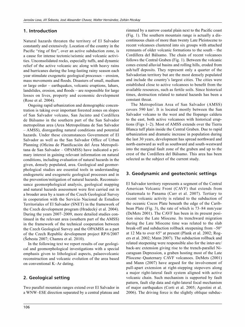
rimmed by a narrow coastal plain next to the Pacific coast (Fig. 1). The southern mountain range is actually a dis-continuous chain of more than twenty Late Pleistocene to recent volcanoes clustered into six groups with attached remnants of older volcanic formations to the south – the Cordillera del Bálsamo. The chain of recent volcanoes follows the Central Graben (Fig. 1). Between the volcanic cones extend alluvial basins and rolling hills, eroded from ash/tuff deposits. They represent only a quarter of the Salvadorian territory but are the most densely populated and include the country’s largest cities. The cities were established close to active volcanoes to benefit from the available resources, such as fertile soils. Since historical times, destruction related to natural hazards has been a constant threat.
The Metropolitan Area of San Salvador (AMSS) covers 590 km2. It is located mostly between the San Salvador volcano to the west and the Ilopango caldera to the east, both active volcanoes with historical erup-tions (Figs 1–2). Most of AMSS extends over the Tierra Blanca tuff plain inside the Central Graben. Due to rapid urbanization and dramatic increase in population during the last 30 years, development has spread northward and north-eastward as well as southward and south-westward into the marginal fault zone of the graben and up to the crest of the Cordillera del Bálsamo. This area has been selected as the subject of the current study.
3. Geodynamic and geotectonic settings
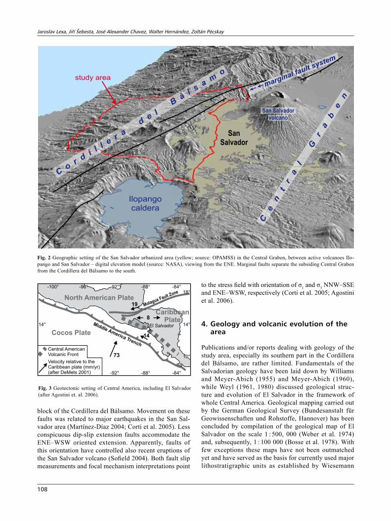
El Salvador territory represents a segment of the Central American Volcanic Front (CAVF) that extends from Guatemala to Panama (Carr et al. 2007). Tertiary to recent volcanic activity is related to the subduction of the oceanic Cocos Plate beneath the edge of the Carib-bean Plate (Fig. 3), the rate of which is 73–84 mm/year (DeMets 2001). The CAVF has been in its present posi-tion since the Late Miocene. Its trenchward migration during the Late Miocene time was related to the slab break-off and subduction rollback steepening from ~50° at 12 Ma to over 65° at present (Plank et al. 2002; Rog-ers et al. 2002; Mann 2007). The subduction rollback and related steepening were responsible also for the inter-arc/back-arc extension giving rise to the trench-parallel Ni-caraguan Depression, a graben hosting most of the Late Pliocene–Quaternary CAVF volcanoes. DeMets (2001) and Mann (2007) have argued for the involvement of pull-apart extension at right-stepping stepovers along a major right-lateral fault system aligned with active volcanic chain. Such mechanism is supported by fault pattern, fault slip data and right-lateral focal mechanism of major earthquakes (Corti et al. 2005; Agostini et al. 2006). The driving force is the slightly oblique subduc-
Geology and volcanic evolution san salvador
107
tion of the Cocos Plate that moves a forearc sliver at the rate of 14 mm/year along the right-lateral El Salvador Fault Zone (ESFZ) formed along the active volcanic axis (DeMets 2001). Between the dextral ESFZ and the sinistral Motagua fault system there is a broad zone with estimated rate of nearly E–W extension of 8 mm/year (Fig. 3).
The geodynamic setting is reflected in the fault pattern of the study area and its surroundings characterized by a combination of the WNW–ESE trending right-lateral strike-slip faults and NNW–SSE to N–S trending dip-slip faults (Fig. 4). Right lateral strike-slip faults having a transtension component limit a subsided block of the Central Graben against the uplifted and southward tilted
Fig. 4
SANVICENTE
SAN MIGUEL
CONCHAGUA
TECAPA
APANECA
SANTA ANA
COATEPEQUE
ILOPANGO
SANSALVADOR
AMSS
STUDY AREA
Pacific Ocean
GuatemalaHonduras
Sierra Madre de Chiapas
Central PlateauCordillera del Bálsamo
Coastal Plain
-90°
-90°
-89°
-89°
-88°
-88°13° 13°
14° 14°
0 50 km
*
Quaternary sedimentarydeposits
Quaternary intermediate andmafic volcanic rocks
Quaternary silicic volcanicrocks (mostly tuffs)
Upper Miocene/Pliocene inter-mediate and mafic volcanic rocks
Fig. 1 Topography and structural outline of El Salvador: a – topography (source: Wiki Commons) with location of the Area Metropolitana de San Salvador (AMSS) and study area; b – structural outline (after Bosse et al. 1978; Hernández 2004; Corti et al. 2005). Note a spatial coincidence of the active volcanic arc and the WNW–ESE trending Central Graben.
Jaroslav Lexa, Jiří Šebesta, José alexander Chavez, Walter hernández, zoltán Pécskay
108
block of the Cordillera del Bálsamo. Movement on these faults was related to major earthquakes in the San Sal-vador area (Martínez-Díaz 2004; Corti et al. 2005). Less conspicuous dip-slip extension faults accommodate the ENE–WSW oriented extension. Apparently, faults of this orientation have controlled also recent eruptions of the San Salvador volcano (Sofield 2004). Both fault slip measurements and focal mechanism interpretations point
to the stress field with orientation of σ1 and σ3 NNW–SSE and ENE–WSW, respectively (Corti et al. 2005; Agostini et al. 2006).
4. Geology and volcanic evolution of the area
Publications and/or reports dealing with geology of the study area, especially its southern part in the Cordillera del Bálsamo, are rather limited. Fundamentals of the Salvadorian geology have been laid down by Williams and Meyer-Abich (1955) and Meyer-Abich (1960), while Weyl (1961, 1980) discussed geological struc-ture and evolution of El Salvador in the framework of whole Central America. Geological mapping carried out by the German Geological Survey (Bundesanstalt für Geowissenschaften und Rohstoffe, Hannover) has been concluded by compilation of the geological map of El Salvador on the scale 1 : 500, 000 (Weber et al. 1974) and, subsequently, 1 : 100 000 (Bosse et al. 1978). With few exceptions these maps have not been outmatched yet and have served as the basis for currently used major lithostratigraphic units as established by Wiesemann
San Salvador
volcano
Ilopangocaldera
study areastudy area
San Salvador
volcano
Co
rd
i l l er
a
de
l
Bá
l sa
mo
��marginal fault system
Ce
nt
ra
l
Gr
ab
en
San
Salvador
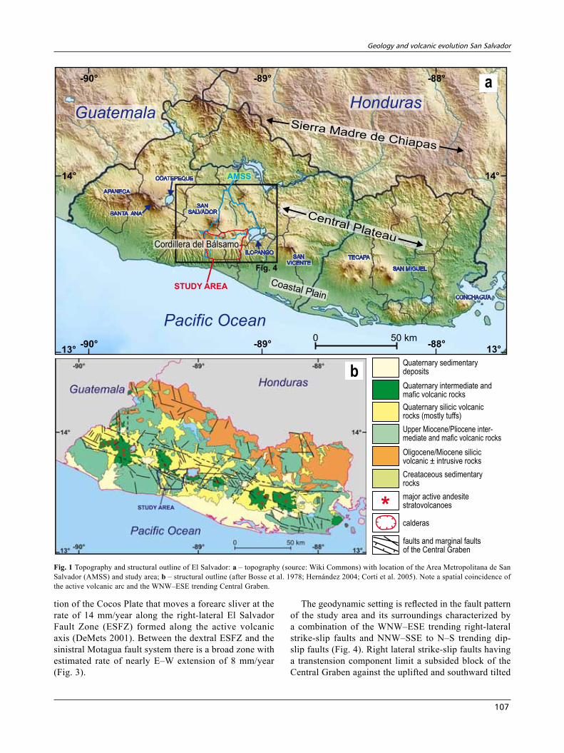
Fig. 2 Geographic setting of the San Salvador urbanized area (yellow; source: OPAMSS) in the Central Graben, between active volcanoes Ilo-pango and San Salvador – digital elevation model (source: NASA), viewing from the ENE. Marginal faults separate the subsiding Central Graben from the Cordillera del Bálsamo to the south.
14°
73
19
8
14
14°
10°
-100° -96° -92°
-92°
-88°
-88°
-84°
-84°
Cocos Plate
North American Plate
Central AmericanVolcanic Front
El SalvadorMiddle America Trench
Motagua Fault Zone
Velocity relative to theCaribbean plate (mm/yr)(after DeMets 2001)
Caribbean
Plate
18°
Fig. 3 Geotectonic setting of Central America, including El Salvador (after Agostini et. al. 2006).
Geology and volcanic evolution san salvador
109
(1975) and Reynolds (1980). Schmidt-Thomé (1975) treated in a greater detail geology in the area of the capi-tal San Salvador, including compilation of a geological map on the scale 1 : 15 000 (Centro de Investigaciones Geotécnicas 1987). This work was later supplemented by the study of the Salvadorian–Italian consortium (Cons-orcio 1988) with emphasis given to properties of rocks and soils and to potential hazards. Reconnaissance studies of geology, geomorphology and natural hazards, carried out by the Czech Geological Survey team in cooperation with the SNET (Hradecký et al. 2003, 2004, 2005; Rap-prich and Hradecký 2005; Rapprich et al. 2010), have brought new ideas concerning volcanic stratigraphy and evolution in different parts of El Salvador including the AMSS. They concluded that the generalized stratigraphic
scheme of Wiesemann (1975) is not suitable for detailed geological mapping that requires lithostratigraphic units respecting local volcanic successions. The well focussed research of Rolo et al. (2004) and Hernández (2004, 2008) was devoted to lithology and geotechnical aspects of the Ilopango caldera tephra deposits (Tierra Blanca) that represent substratum of the central and eastern parts of the city San Salvador.
4.1. Geological setting and lithostratigraphic units
The area of study in the Cordillera del Bálsamo and Cen-tral Graben of El Salvador (Figs 1, 3) represents a small part in the northern segment of the Tertiary to Quaternary
-89°30’
-89°30’
-89°20’
13°40’13°4
0’13°50’13
°50’
-89°20’
-89°10’
-89°10’
-89°00’
-89°00’
San Salvador
Santa Tecla
Soyapango
Ilopango
ICSJ
LL
SS
Jayaque
ignimbrites
Ilopango
ignimbrites
NE
GU
CJ
mapped area
P
J a y a q u e v o l ca
no
Panc h im a lco
volcano
I l op
a n g o v o l ca
no
0 5 km
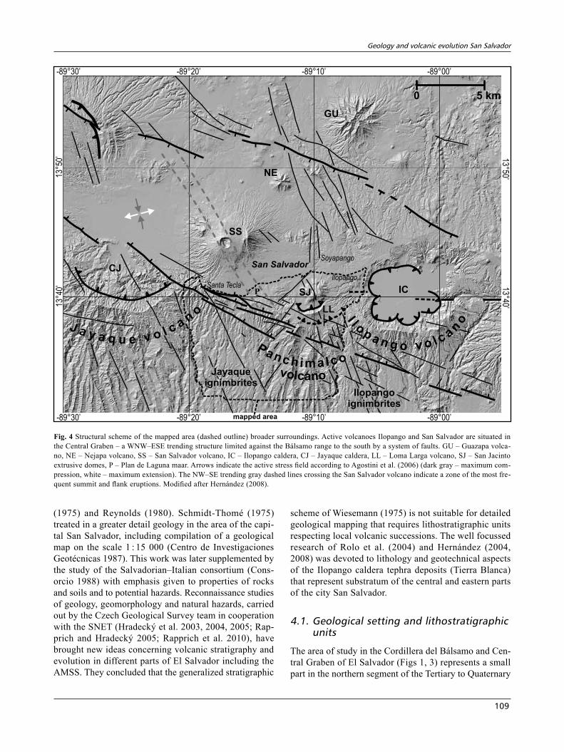
Fig. 4 Structural scheme of the mapped area (dashed outline) broader surroundings. Active volcanoes Ilopango and San Salvador are situated in the Central Graben – a WNW–ESE trending structure limited against the Bálsamo range to the south by a system of faults. GU – Guazapa volca-no, NE – Nejapa volcano, SS – San Salvador volcano, IC – Ilopango caldera, CJ – Jayaque caldera, LL – Loma Larga volcano, SJ – San Jacinto extrusive domes, P – Plan de Laguna maar. Arrows indicate the active stress field according to Agostini et al. (2006) (dark gray – maximum com-pression, white – maximum extension). The NW–SE trending gray dashed lines crossing the San Salvador volcano indicate a zone of the most fre-quent summit and flank eruptions. Modified after Hernández (2008).
Jaroslav Lexa, Jiří Šebesta, José alexander Chavez, Walter hernández, zoltán Pécskay
110
CAVF, parallel to the Pacific coast and Middle America Trench (Stoiber and Carr 1973). Widespread intermedi-ate/silicic volcanics of the Oligocene–Miocene Morazán and Chalatenango formations (Fig. 1), mostly andesitic to rhyolitic ignimbrites, were related to calderas behind the present volcanic arc north of the Central Graben (Reyn-olds 1980). A change in geometry of the subduction zone following a slab detachment during the Late Miocene resulted in migration of the volcanic arc axis closer to the trench roughly into its present position (Mann 2007). Three volcanic formations represent products of the CAVF in its present position (Fig. 1): the Late Miocene–Pliocene Bálsamo Formation, the Late Pliocene–Early Pleistocene Cuscatlán Formation and the Late Pleisto-cene–Holocene San Salvador Formation (Wiesemann 1975; Bosse et al. 1978; Reynolds 1980). The BálsamoFormation is built by andesite lavas, tuffs and epiclastic volcanic breccias/conglomerates representing remnants of andesite stratovolcanoes. The CuscatlánFormation comprises silicic domes, tuffs, ignimbrites and volcanic sediments related to calderas, interstratified locally with basaltic and/or andesitic lavas. The SanSalvadorForma-tion includes products of basalt–andesite stratovolcanoes associated with the evolution of the Central Graben as well as interstratified silicic tephra/ignimbrites of the Coatepeque and Ilopango calderas.
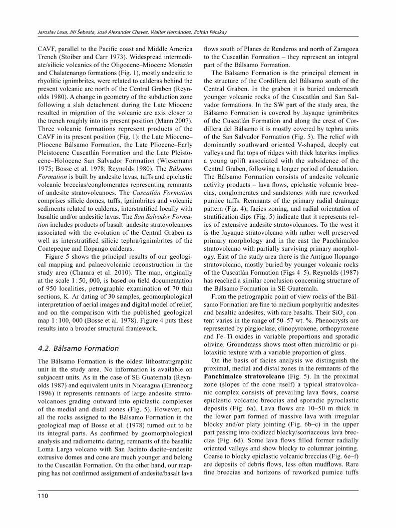
Figure 5 shows the principal results of our geologi-cal mapping and palaeovolcanic reconstruction in the study area (Chamra et al. 2010). The map, originally at the scale 1 : 50, 000, is based on field documentation of 950 localities, petrographic examination of 70 thin sections, K–Ar dating of 30 samples, geomorphological interpretation of aerial images and digital model of relief, and on the comparison with the published geological map 1 : 100, 000 (Bosse et al. 1978). Figure 4 puts these results into a broader structural framework.
4.2. bálsamo Formation
The Bálsamo Formation is the oldest lithostratigraphic unit in the study area. No information is available on subjacent units. As in the case of SE Guatemala (Reyn-olds 1987) and equivalent units in Nicaragua (Ehrenborg 1996) it represents remnants of large andesite strato-volcanoes grading outward into epiclastic complexes of the medial and distal zones (Fig. 5). However, not all the rocks assigned to the Bálsamo Formation in the geological map of Bosse et al. (1978) turned out to be its integral parts. As confirmed by geomorphological analysis and radiometric dating, remnants of the basaltic Loma Larga volcano with San Jacinto dacite–andesite extrusive domes and cone are much younger and belong to the Cuscatlán Formation. On the other hand, our map-ping has not confirmed assignment of andesite/basalt lava
flows south of Planes de Renderos and north of Zaragoza to the Cuscatlán Formation – they represent an integral part of the Bálsamo Formation.
The Bálsamo Formation is the principal element in the structure of the Cordillera del Bálsamo south of the Central Graben. In the graben it is buried underneath younger volcanic rocks of the Cuscatlán and San Sal-vador formations. In the SW part of the study area, the Bálsamo Formation is covered by Jayaque ignimbrites of the Cuscatlán Formation and along the crest of Cor-dillera del Bálsamo it is mostly covered by tephra units of the San Salvador Formation (Fig. 5). The relief with dominantly southward oriented V-shaped, deeply cut valleys and flat tops of ridges with thick laterites implies a young uplift associated with the subsidence of the Central Graben, following a longer period of denudation. The Bálsamo Formation consists of andesite volcanic activity products – lava flows, epiclastic volcanic brec-cias, conglomerates and sandstones with rare reworked pumice tuffs. Remnants of the primary radial drainage pattern (Fig. 4), facies zoning, and radial orientation of stratification dips (Fig. 5) indicate that it represents rel-ics of extensive andesite stratovolcanoes. To the west it is the Jayaque stratovolcano with rather well preserved primary morphology and in the east the Panchimalco stratovolcano with partially surviving primary morphol-ogy. East of the study area there is the Antiguo Ilopango stratovolcano, mostly buried by younger volcanic rocks of the Cuscatlán Formation (Figs 4–5). Reynolds (1987) has reached a similar conclusion concerning structure of the Bálsamo Formation in SE Guatemala.
From the petrographic point of view rocks of the Bál-samo Formation are fine to medium porphyritic andesites and basaltic andesites, with rare basalts. Their SiO2 con-tent varies in the range of 50–57 wt. %. Phenocrysts are represented by plagioclase, clinopyroxene, orthopyroxene and Fe–Ti oxides in variable proportions and sporadic olivine. Groundmass shows most often microlitic or pi-lotaxitic texture with a variable proportion of glass.
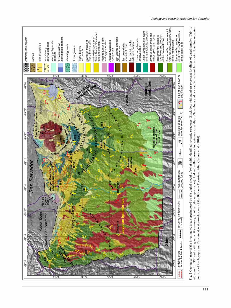
On the basis of facies analysis we distinguish the proximal, medial and distal zones in the remnants of the Panchimalco stratovolcano (Fig. 5). In the proximal zone (slopes of the cone itself) a typical stratovolca-nic complex consists of prevailing lava flows, coarse epiclastic volcanic breccias and sporadic pyroclastic deposits (Fig. 6a). Lava flows are 10–50 m thick in the lower part formed of massive lava with irregular blocky and/or platy jointing (Fig. 6b–c) in the upper part passing into oxidized blocky/scoriaceous lava brec-cias (Fig. 6d). Some lava flows filled former radially oriented valleys and show blocky to columnar jointing. Coarse to blocky epiclastic volcanic breccias (Fig. 6e–f) are deposits of debris flows, less often mudflows. Rare fine breccias and horizons of reworked pumice tuffs
Geology and volcanic evolution san salvador
111
1332 °’1334 °’1336 °’1338 °’1340 °’
-89
20’
°-8
918°
’
-89°
18’
-89°
16’
-89
16°’
-89°
14’
-89°
14’
-89
12°’
-89
12°’
-89
10°’
-89
10°’
-89°
08’
-89°
08’
-89°
06’
-89°
06’
1332 °’1334 °’1336 °’1338 °’1340 °’
-89
20°’
Sa
nta
Te
cla
Nu
eva
Sa
nS
alv
ad
or
Pla
nd
e
La
gu
na
ma
ar
An
tig
uo
Cu
sc
atl
án
sc
oria
co
ne
flu
via
lto
ma
rin
e
fac
ies
of
the
dis
tal
zo
ne
r
in
gp
la
in
of
th
em
ed
ia
lz
on
e
Ja
ya
qu
eig
nim
brit
es
Ilo
pa
ng
o
ign
imb
rit
es
Jayaque
str
ato
volc
ano
Ilopango
strato
volcano
Sa
nJ
os
e
co
ne
Sa
nJ
ac
into
do
me
s
co
ne
Sa
nS
alv
ad
or
Ilo
pa
ng
o
Pa
nc
hi-
ma
lco
Nu
ev
oC
us
ca
tlá
n
Olo
cu
ilta
Ro
sa
rio
de
Mo
ra
Za
ra
go
za
Sa
nto
To
má
s
Hu
izu
ca
r
CalderaP
lanes
de
Ren
dero
s
L
om
aL
ar
ga
vo
lc
a
n
o
Ca
ld
er
aS
an
to
To
ma
s
�
Pa
n
ch
im
alc
os
tr
at
ov
olc
an
o
ri
ng
pl
ai
no
ft
he
me
dia
lz
on
e
�•1
7
•5•4
•33
2
•17
8
• 28
8
• 36
2
• 55
• 73
• 16
6
•19
3
•46
•44
•55
4
•59
1
•21
0
• 211
• 67
3
•
•9
•86
8
•20
•82
9
15
1
��
�3
5
3
2 �
�
10
��
53
3
��
��
22
10
30
15
�
�
�
14
20 �
�
��
�
�
��
10
15
10
13
10
8
6
�
�
8
10
5�
�
�
��
��
�7
8
12
6
5
6
�
10
15
5
5
�
�4
�
���
�
3
3
54
5
�
���
�3
5
5
58
�
���2
3
4
4
������
�
54
3
2
2
9
3
8
�
�
�
�4
3
4
�
��
�
�
�� �
�
�
�
5
55
10
10
5
841
0
10
3
�10
� �10
8
��
� 151
51
4
Ant
hrop
ogen
ous
depo
sits
rockfa
ll
pla
na
rla
nd
slid
e
sto
ny/lo
am
yd
elu
via
ld
ep
osits
sa
nd
yp
oly
ge
ne
tic
de
po
sits
flu
via
l/la
cu
str
ine
allu
via
lp
lain
de
po
sits
allu
via
lg
rave
ls
flu
via
lg
rave
ls
Tie
rra
Bla
nca
tuff
co
mp
lex
rew
ork
ed
facie
so
fT
ierr
aB
lan
ca
tuffs
un
div
ide
dco
mp
lex
of
Tie
rra
Bla
nca
/C
usca
tla
ntu
ffs
an
dla
terite
s
Pla
nd
eL
ag
un
atu
ffs
an
da
gg
lom
era
tes
An
tig
uo
Cu
sca
tla
nsco
ria
co
ne
•46
loca
litie
so
fd
ate
dsa
mp
les
(se
eTa
b.
1)
Sa
nJa
cin
toa
nd
esite
effu
siv
eco
ne
Sa
nJo
sé
da
cite
sco
ria
/tu
ffco
ne
Sa
nJa
cin
tod
acite
extr
usiv
ed
om
es
Lo
ma
La
rga
ba
sa
ltic
effu
siv
eco
ne
Lo
ma
La
rga
ba
sa
ltic
flo
ws
an
dh
ya
locla
stite
bre
ccia
s
Ja
ya
qu
eig
nim
brite
sa
nd
min
or
ep
icl.
vo
lc.
rocks
Ba
lsa
mo
Fm
:a
nd
esite
lava
flo
ws
an
db
reccia
so
fth
ep
roxim
alzo
ne
Ba
lsa
mo
Fm
:a
nd
esite
vo
lc.
bre
ccia
s/c
on
glo
me
rate
so
fth
em
ed
ialzo
ne
ep
icl.
Ba
lsa
mo
Fm
:a
nd
esite
ep
icl.
vo
lc.
co
ng
lom
era
tes
of
the
dis
talzo
ne
lan
dslid
esca
rsd
iastr
op
hic
blo
ck
fau
lts
assu
me
dca
lde
rafa
ults
(co
ve
red
)a
ssu
me
dfa
ults
co
ve
red
fau
lts
cra
ters
��4
4d
ips
of
lava
flo
ws
or
str
atifica
tio
n
02
km
Fig.
5 G
eolo
gica
l map
of t
he in
vest
igat
ed a
rea
supe
rimpo
sed
on th
e di
gita
l mod
el o
f rel
ief w
ith id
entifi
ed v
olca
nic
stru
ctur
es. B
lack
dot
s w
ith n
umbe
rs re
pres
ent l
ocal
ities
of d
ated
sam
ples
(Tab
. 1;
add
a pr
efix
“SS”
and
trai
ling
zero
s, if
nec
essa
ry, t
o ob
tain
the
sam
ple
nam
es).
Red
and
yel
low
arr
ows
indi
cate
mea
sure
d di
ps o
f lav
a flo
ws
and
or s
tratifi
ed v
olca
nicl
astic
rock
s. B
lue
line
sepa
rate
s do
mai
ns o
f the
Jay
aque
and
Pan
chim
alco
stra
tovo
lcan
oes
of th
e B
álsa
mo
Form
atio
n. A
fter C
ham
ra e
t al.
(201
0).
Jaroslav Lexa, Jiří Šebesta, José alexander Chavez, Walter hernández, zoltán Pécskay
112
showing incipient sorting and stratification are interpreted as hyperconcentrated flow deposits. Fragments represent an assemblage of various basaltic andesites and pyroxene
andesites mostly coming from disintegration of lava flows (Fig. 6e). Scoriaceous fragments of the pyroclastic origin are less frequent. Fragments are angular to subangular,
e
ba
f
c d
20 cm
Fig. 6 The Panchimalco stratovolcano proximal zone: a – stratovolcanic complex of inclined lava flows and coarse epiclastic volcanic breccias, Puerta del Diablo (13°37′28.5″N, –89°11′23.1″W); b – steeply dipping pyroxene andesite lava flow with blocky jointing, Puerta del Diablo; c – base of basaltic andesite lava flow with platy jointing, SW of Panchimalco (13°35′59.1″N, –89°10′6.56″W); d – blocky scoriaceous lava breccia of glas-sy pyroxene andesite, SW of Panchimalco (13°35′57.4″N, –89°11′26.7″W); e – epiclastic volcanic breccia, Puerta del Diablo; f – epiclastic volca-nic breccia, S of Puerta del Diablo (13°36′32.3″N, –89°11′32.6″W).
Geology and volcanic evolution san salvador
113
up to 1 m across, 10–30 cm on the average. Their pro-portion in the deposits varies from 50 to 85 %. Matrix of the breccias is unsorted, coarse sandy, with a variable admixture of pumice and ash. The increased proportion of pumice and ash, implying rare Vulcanian type eruptions, is characteristic of matrix in mudflow deposits. Stratifica-tion and sorting are either absent or inconspicuous with exception of rare horizons of fine breccias and reworked tuffs. Primary dip of deposition was 10–15°, dominantly periclinal in respect of the assumed volcanic centre in the San Jacinto area.
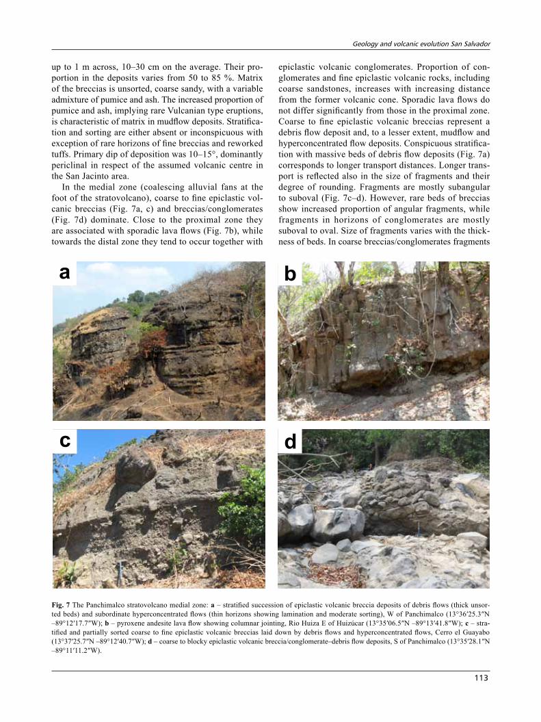
In the medial zone (coalescing alluvial fans at the foot of the stratovolcano), coarse to fine epiclastic vol-canic breccias (Fig. 7a, c) and breccias/conglomerates (Fig. 7d) dominate. Close to the proximal zone they are associated with sporadic lava flows (Fig. 7b), while towards the distal zone they tend to occur together with
epiclastic volcanic conglomerates. Proportion of con-glomerates and fine epiclastic volcanic rocks, including coarse sandstones, increases with increasing distance from the former volcanic cone. Sporadic lava flows do not differ significantly from those in the proximal zone. Coarse to fine epiclastic volcanic breccias represent a debris flow deposit and, to a lesser extent, mudflow and hyperconcentrated flow deposits. Conspicuous stratifica-tion with massive beds of debris flow deposits (Fig. 7a) corresponds to longer transport distances. Longer trans-port is reflected also in the size of fragments and their degree of rounding. Fragments are mostly subangular to suboval (Fig. 7c–d). However, rare beds of breccias show increased proportion of angular fragments, while fragments in horizons of conglomerates are mostly suboval to oval. Size of fragments varies with the thick-ness of beds. In coarse breccias/conglomerates fragments
ba
c d
Fig. 7 The Panchimalco stratovolcano medial zone: a – stratified succession of epiclastic volcanic breccia deposits of debris flows (thick unsor-ted beds) and subordinate hyperconcentrated flows (thin horizons showing lamination and moderate sorting), W of Panchimalco (13°36′25.3″N –89°12′17.7″W); b – pyroxene andesite lava flow showing columnar jointing, Rio Huiza E of Huizúcar (13°35′06.5″N –89°13′41.8″W); c – stra-tified and partially sorted coarse to fine epiclastic volcanic breccias laid down by debris flows and hyperconcentrated flows, Cerro el Guayabo (13°37′25.7″N –89°12′40.7″W); d – coarse to blocky epiclastic volcanic breccia/conglomerate–debris flow deposits, S of Panchimalco (13°35′28.1″N –89°11′11.2″W).
Jaroslav Lexa, Jiří Šebesta, José alexander Chavez, Walter hernández, zoltán Pécskay
114
are up to 80 cm in diameter (Fig. 7c–d) but mostly in the range 5–20 cm (Fig. 7c). Proportion of fragments varies between 50 and 90 %. Matrix is unsorted, coarse sandy, with a variable admixture of pumice and ash. Stratifica-tion and sorting are variously expressed, reflecting pro-portion of fine-grained beds and hyperconcentrated flow deposits. Primary dip of deposition was 4–10°, mostly periclinal in respect of the assumed volcanic centre in the San Jacinto area (Fig. 5).
In the distal zone, epiclastic volcanic conglomerates and sandstones dominate over rare thick horizons of breccias deposited by mudflows. The large proportion of coarse clastic rocks reflects a very fast input of coarse material by incoming mudflows, debris flows and hyper-concentrated flows. The complex of conglomerates and sandstones is well stratified (Fig. 8a) and shows a higher degree of sorting. Textures and lateral variability indicate deposition in the environment of alluvial plain braided rivers and, south of the study area, in the coastal zone of
shallow sea. Of the alluvial plain environment conglom-erates with a lesser degree of pebble rounding are char-acteristic. Textures indicate transport and deposition by debris flows (Fig. 8c), hyperconcentrated flows (Fig. 8b), or traction (such as imbrication, inclined bedding, erosion channels and lateral wedging out). Coarse conglomerates with pebbles up to 0.5 m in diametre dominate. However, sorted fine conglomerates and coarse sandstones represent a substantial component. An association of coarse to very coarse conglomerates having well rounded pebbles with horizons of well sorted sandstones (Fig. 8d) is character-istic of the shallow marine environment. Primary dip of deposition was 0–4°.
In the western half of the study area the Bálsamo Formation is represented by remnants of the Jayaque stratovolcano. It is well expressed in morphology by a radially oriented drainage pattern that reflects former slopes of the stratovolcano (Figs 1, 4). As in the case of the Panchimalco stratovolcano, we distinguish three
ba
c d
Fig. 8 The Panchimalco stratovolcano distal zone: a – well stratified succession of epiclastic volcanic conglomerates, SW of San Sebastian (13°31′50.8″N, –89°8′22.9″W); b – epiclastic volcanic conglomerates deposited by hyperconcentrated flows, Loma La Angostura (13°31′59.3″N, –89°13′2.65″W); c – coarse epiclastic volcanic conglomerate laid down by debris flow, El Potrerito (13°33′45.2″N, –89°11′14.9″W); d – well sor-ted epiclastic volcanic conglomerates and sandstones deposited in the shallow marine environment, Santa Barbara (13°30′26.5″N, –89°12′29.0″W).
Geology and volcanic evolution san salvador
115
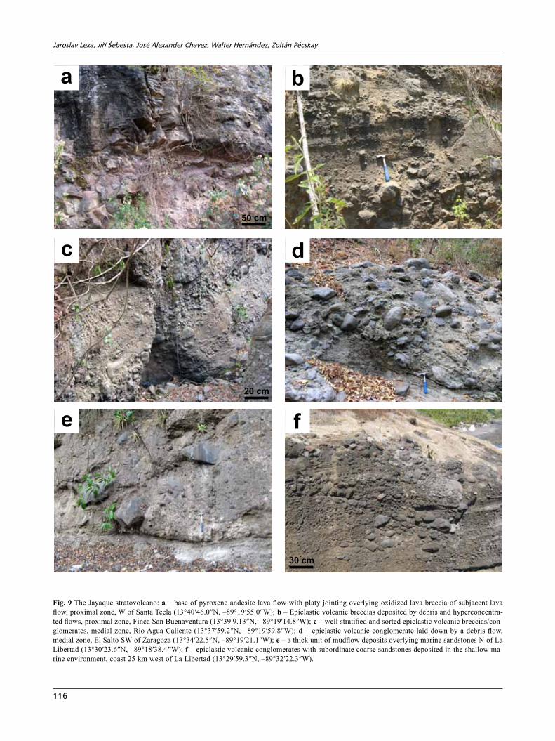
facial zones (Fig. 5): (1) the proximal zone with lava flows (Fig. 9a) prevailing over mostly coarse epiclastic volcanic breccias (Fig. 9b), primary periclinal dips be-ing 10–15°; (2) the medial zone where coarse to fine epiclastic volcanic breccias and breccias/conglomerates (Fig. 9c) dominate over subordinate lava flows (on the side of the proximal zone) and subordinate conglomerates (on the side of distal zone) (Fig. 9d), primary periclinal dips being 5–10°; (3) the distal zone with prevailing epi-clastic volcanic conglomerates and sandstones that have been deposited in the alluvial plain (north) and shallow marine (south) environments (Fig. 9e), primary dips be-ing 0–5°; conglomerates and sandstones include locally thick horizons of mudflow deposits (Fig. 9f). As far as petrography and lithology are concerned, rocks of the Jayaque stratovolcano are mostly equivalent to those of the Panchimalco stratovolcano described above.
Between the well defined stratovolcanoes Jayaque and Panchimalco there is a rather flat area east and west of Nuevo Cuscatlán (Fig. 5) where the drainage pattern does not show radial pattern comparable to these stratovolca-noes. It rather reflects post-volcanic uplift and oceanward tilting of the Cordillera del Bálsamo (Fig. 4). Eastward dipping stratovolcanic complex dominated by lava flows in the western part of this area belongs unquestionably to the Jayaque stratovolcano. Assignment of the subho-rizontal complex of epiclastic volcanic breccias and lava flows around Nuevo Cuscatlán is not so straightforward. Due to the abundance of lava flows east of Nuevo Cus-catlán, this area has been assigned in the geological map to the stratovolcanic complexes of the proximal zone (Fig. 5). However, the subhorizontal primary position and character of associated epiclastic volcanic rocks point to the effusive complex of the medial zone. Sporadic W–E orientation of lava flows and results of radiometric dating (see below) imply that lava flows as well as associated epiclastic breccias belong to the Jayaque stratovolcano.
Geological mapping and facies analysis have demon-strated that the Bálsamo Formation in the study area rep-resents remnants of two large basaltic andesite–andesite stratovolcanoes, westerly Jayaque and easterly Panchi-malco. The large size of their cones and extent of their ring plains (Fig. 5) exceed significantly parameters of any active Quaternary volcano of El Salvador (Fig. 1). If we take boundary of the proximal and medial zones as the foot of the former stratovolcanic cones, the Panchimalco stratovolcano had a diameter of 15 km and a relative height of 2,000–2,500 m. Jayaque stratovolcano could have had even a diameter of 30 km and a relative height of 3,000–4,000 m. Width of their medial zone ring-plain was 5–8 km and 8–12 km respectively. The extensive ring-plain is a characteristic feature of stratovolcanoes evolving in the areas of subtropical or tropical climate with high precipitation. Active volcano Ruapehu in New
Zealand may serve as a good example (Hackett and Houghton 1989). The assemblage of the facies and types of fragments in epiclastic volcanic rocks (see above) point to dominantly effusive activity associated with the Strombolian type of eruptions, interrupted by short periods of the Vulcanian type. A schematic facies model of the Bálsamo Formation in the study area and surround-ings is presented in Fig. 10. Evolution of the Jayaque and Panchimalco stratovolcanoes was not interrupted by any significant period of explosive activity of the Plinian type (absence of corresponding tuffs/ignimbrites). However, their central zones were affected by subsequent evolution of calderas and continuing volcanic activity of the Cus-catlán Formation. Timing of volcanic activity is discussed in the Section 5, “Volcanic evolution of the area”.
4.3. Cuscatlán Formation
The Cuscatlán Formation does not form a continuous mappable unit in the study area. Assignment of rocks to the formation might be sometimes questionable. To avoid misunderstanding we respect the view of Reynolds (1980, 1987) who defined the Cuscatlán Formation as an assemblage of dominantly silicic explosive volcanic activity products associated with evolution of calderas, younger or contemporaneous to the Bálsamo Formation, including reworked counterparts and interstratified and/or overlying silicic to mafic lavas. In the study area the Cuscatlán Formation rests on rocks of the Bálsamo For-mation and along the crest of the Cordillera del Bálsamo. In the Central Graben it is covered by tephra and other rocks of the San Salvador Formation (Fig. 5).
In the study area, the Cuscatlán Formation consists of several members, some of which are newly defined. Extensive dacite–andesite Jayaque ignimbrites in the SW part of the study area and Ilopango ignimbrites SE of the study area (Figs 4–5) represent the oldest member rest-ing on the denudated surface of the Bálsamo Formation. These ignimbrites are believed to be related to the Jayaque and Antiguo Ilopango calderas. Contrary to the situation in SE Guatemala, where source calderas of the Cuscatlán Formation intermediate–silicic ignimbrites were situated behind the volcanic front (Reynolds 1987), in El Salvador these are situated in the central zones of major Bálsamo Formation andesite stratovolcanoes (Jayaque and Antiguo Ilopango?). Basaltic volcano Loma Larga in the Santo Tomás caldera, dacite–andesite San Jacinto extrusive domes and cone in the Planes de Renderos caldera, dacitic San José scoria cone and andesitic Antiguo Cuscatlán scoria cone (Fig. 5) represent younger, newly defined members of the Cuscatlán Formation. The first two of these members were formerly assigned to the Bálsamo Formation (Bosse et al. 1978). Figure 11 demonstrates as-sumed superposition of the Cuscatlán Formation members
Jaroslav Lexa, Jiří Šebesta, José alexander Chavez, Walter hernández, zoltán Pécskay
116
e
ba
f
c d
50 cm
20 cm
30 cm
Fig. 9 The Jayaque stratovolcano: a – base of pyroxene andesite lava flow with platy jointing overlying oxidized lava breccia of subjacent lava flow, proximal zone, W of Santa Tecla (13°40′46.0″N, –89°19′55.0″W); b – Epiclastic volcanic breccias deposited by debris and hyperconcentra-ted flows, proximal zone, Finca San Buenaventura (13°39′9.13″N, –89°19′14.8″W); c – well stratified and sorted epiclastic volcanic breccias/con-glomerates, medial zone, Rio Agua Caliente (13°37′59.2″N, –89°19′59.8″W); d – epiclastic volcanic conglomerate laid down by a debris flow, medial zone, El Salto SW of Zaragoza (13°34′22.5″N, –89°19′21.1″W); e – a thick unit of mudflow deposits overlying marine sandstones N of La Libertad (13°30′23.6″N, –89°18′38.4”W); f – epiclastic volcanic conglomerates with subordinate coarse sandstones deposited in the shallow ma-rine environment, coast 25 km west of La Libertad (13°29′59.3″N, –89°32′22.3″W).
Geology and volcanic evolution san salvador
117
on the denudated surface of the Bálsamo Formation (Pan-chimalco stratovolcano) based on the field relationships and radiometric dating. Inferior tephra deposits of the Ilopango/Coatepeque calderas including reworked facies represent the youngest member of the Cuscatlán Forma-tion. Bosse et al. (1978) have assigned to this member also reworked silicic tuffs underneath pyroclastic flows of the Tierra Blanca Joven west of the Ilopango caldera. How-ever, reworking of tuffs was syngenetic with Tierra Blanca Joven eruptions and thus these reworked silicic tuffs seem to belong to the San Salvador Formation. Also, most of the brownish tuffs below the Tierra Blanca tephra units known as “Tobas color café” have been assigned to the Congo and Arce tephra units of the Coatepeque caldera (Rose et al. 1999), representing the oldest members of the San Salvador Formation (Hernández 2008).
4.3.1. Jayaque ignimbrites
The Jayaque ignimbrites form an almost continuous cover in the SW part of the study area, extending southward
all the way to the Pacific coast (Figs 4–5). As evidenced by erosional remnants, their original extent was much larger. They were laid down in palaeo-valleys on slopes of the Jayaque stratovolcano as well as on the flat relief between the Jayaque and Panchimalco stratovolcanoes. Their thickness varies from a few metres to c. 120 m. As they are present also higher on the slopes of the Jayaque stratovolcano and in the Jayaque caldera (Bosse et al. 1978), the said caldera was most probably their source.
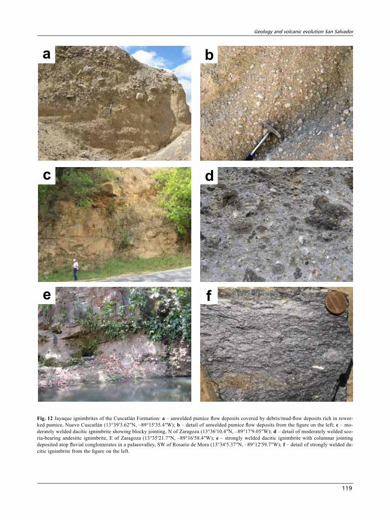
Jayaque ignimbrites are highly variable as far as composition and degree of welding are concerned. Composition varies from pale pumice-flows of rhyo-dacitic composition (Fig. 12b) to dark scoria-containing types of andesitic composition (Fig. 12d). Slightly to moderately welded facies dominate over unwelded and strongly welded ones. Strongly welded ignimbrites are dense glassy with vitrified matrix and former pumice turned into dark fiamme (Fig. 12f). They show blocky or columnar jointing and, owing to their resistance to weathering, form table-mountains and cuestas. Moder-ately welded ignimbrites do not show pumice fragment
North South20 – 30 kmproximal zone
medial zonedistal zone
andesite lava flows
coarse to blocky epicl. volc.breccias – mudflow deposits
Fig. 10 Facies model of the Bálsamo Formation andesite stratovolcanoes Jayaque and Panchimalco.
Panchimalco stratovolcano
Loma Largavolcano
San Jacinto domes
Jayaque ignimbrites
SanJacintocone
Caldera Planes de RenderosCaldera Santo TomasN S
Fig. 11 Superposition of established geological units in the central part of the study area.
Jaroslav Lexa, Jiří Šebesta, José alexander Chavez, Walter hernández, zoltán Pécskay
118
deformation and secondary vitrification, however, their increased strength is reflected in characteristic blocky jointing (Fig. 12c). Unwelded ignimbrites (pumice flow deposits) occur at the base and top of welded ones as well as independent flow units (Fig. 12a–b). The Jayaque ignimbrites as lithostratigraphic unit include sporadic epi-clastic volcanics and reworked pyroclastic rocks. Fluvial conglomerates and mudflow deposits containing pumice and ash in matrix occur underneath ignimbrites in palaeo-valleys (Fig. 12e). In outcrops close to Nuevo Cuscatlán (Fig. 12a) unwelded pumice flow deposits are covered by a succession of mudflow and debris flow deposits with matrix rich in pumice and ash remobilized from underly-ing pumice flow deposits.
Jayaque ignimbrites represent products of voluminous Plinian type explosive eruptions, most probably associ-ated with the initial stage of the Jayaque caldera subsid-ence. Their original extent and volume were much greater than preserved nowadays. Variability in composition and observed order of flow/cooling units in areas of large thickness imply a succession of eruptions. Contempo-raneous reworking of explosive material is evidenced by underlying, interstratified and overlying horizons of epiclastic volcanic deposits rich in pumice and ash component.
4.3.2. santo tomás caldera
It is evident from morphology that the Loma Larga vol-cano evolved in a caldera that we have named the Santo Tomás caldera. It is situated in the central zone of the former Panchimalco stratovolcano, having the diameter of 8 km (Fig. 5). Collapse calderas are usually associ-ated with voluminous explosive eruptions giving rise to ignimbrites. We are not aware of any ignimbrites that could be correlated with the Santo Tomás caldera with one exception – the Ilopango ignimbrites SE of the study area. They were probably related to the earlier stage in evolution of the Ilopango volcano and caldera. However, a possibility that they were linked to the Santo Tomás caldera can not be ruled out. A relatively older age of the caldera follows from the fact that some of the lava flows of the Loma Larga volcano entered valleys draining the caldera southward – in the time of the Loma Larga volcano activity the caldera was already in the advanced stage of erosion.
4.3.3. Loma Larga volcano
The basaltic volcano whose well-preserved southern part forms the crescent of the Loma Larga ridge SW of San Salvador (Figs 4–5, 13a, 15a) we define as the Loma Larga volcano (Fig. 5). Remnants of the Loma Larga vol-cano build up also diastrophic blocks west of the Planes
de Renderos caldera. Underneath a cover of Tierra Blanca tephra they extend in marginal parts of the Santo Tomás caldera north and southwest of Santo Tomás. Other parts of the volcano have been destroyed by the subsidence of the Planes de Renderos caldera, evolution of the San Jacinto extrusive domes and by the continuous subsid-ence of the Central Graben. Bosse et al. (1978) included rocks of the Loma Larga volcano into the Bálsamo For-mation. However, the fact that the volcano evolved in the caldera Santo Tomás and younger age place it to mafic members of the Cuscatlán Formation.
Rocks of the Loma Larga volcano are fine- to medium-grained olivine-bearing high-alumina basalts with SiO2 contents of c. 50 %. Phenocrysts of An-rich plagioclase, olivine, clinopyroxene and Fe–Ti oxides rest in ground-mass of a microlitic or pilotaxitic texture.
Lava flows with periclinal dips of 20–30° dominate in structure of the volcanic cone (Fig. 13b). Individual lava flows are 5–30 m thick. Their lower part is formed of massive lava with platy to blocky jointing. Upward in the flow section lava becomes porous and changes into a reddish or black scoriaceous breccias of the aa or block type. We have observed a larger accumulation of scoria agglomerates and subordinate lapilli tuffs representing deposits of the Strombolian type of erup-tions in the valley of Rio Ilohuapa only (Fig. 13c). In the area of diastrophic blocks west of the Planes de Renderos caldera the Loma Larga volcano is repre-sented by effusive complex of thicker lava flows with rare accumulations of coarse blocky breccias probably of the hyaloclastite type. Unquestionable hyaloclastite breccias associate with lava flows in the eastern sector of the former volcano (quebradas NE of Santo Tomás) (Fig. 13d). Hyaloclastite breccias are fine to coarse, formed by glassy polygonal angular fragments in the proportion of 60–90 %. Transitions among breccias and highly fractured lava have been observed. A part of the hyaloclastites shows incipient stratification and sorting indicating a local reworking. Extensive presence of hyaloclastites implies that at the time of the Loma Larga volcano activity there was a lake present in this part of the Planes de Renderos caldera. South of the Loma Larga volcano lava flows entered the valleys draining the Santo Tomás caldera southward.
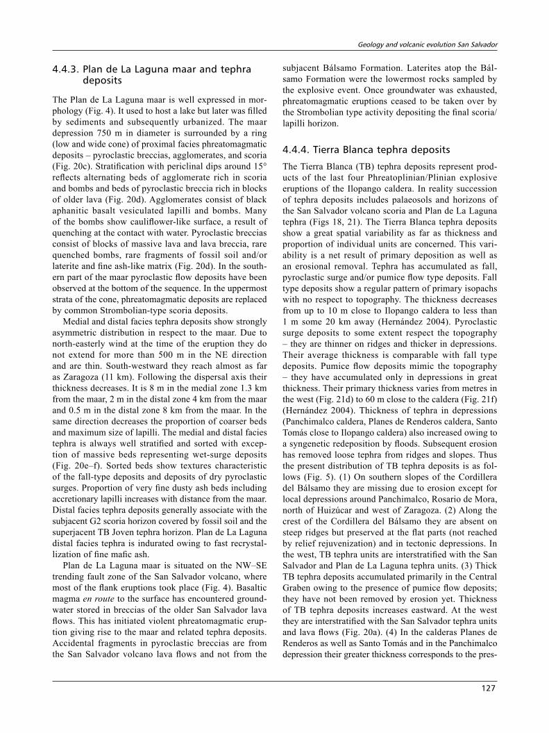
4.3.4. Planes de renderos caldera
Remnants of the Planes de Renderos caldera, with a diameter of 4 km, occur in the central zone of the Loma Larga volcano (Figs 5, 13a, 15a). Most of the caldera is occupied by the San Jacinto extrusive domes and effusive cone, leaving only a narrow moat between the domes and caldera wall. The northern part of the caldera subsided in the Central Graben and is covered by a thick complex
Geology and volcanic evolution san salvador
119
e
ba
f
c d
Fig. 12 Jayaque ignimbrites of the Cuscatlán Formation: a – unwelded pumice flow deposits covered by debris/mud-flow deposits rich in rewor-ked pumice, Nuevo Cuscatlán (13°39′3.62″N, –89°15′35.4″W); b – detail of unwelded pumice flow deposits from the figure on the left; c – mo-derately welded dacitic ignimbrite showing blocky jointing, N of Zaragoza (13°36′10.4″N, –89°17′9.05″W); d – detail of moderately welded sco-ria-bearing andesitic ignimbrite, E of Zaragoza (13°35′21.7″N, –89°16′58.4″W); e – strongly welded dacitic ignimbrite with columnar jointing deposited atop fluvial conglomerates in a palaeovalley, SW of Rosario de Mora (13°34′5.37″N, –89°12′59.7″W); f – detail of strongly welded da-citic ignimbrite from the figure on the left.
Jaroslav Lexa, Jiří Šebesta, José alexander Chavez, Walter hernández, zoltán Pécskay
120
of younger tephra deposits. Apparently, no voluminous pyroclastic deposits could be related to the caldera. Its subsidence was compensated rather by the growth of San Jacinto andesite–dacite extrusive domes.
4.3.5. san Jacinto extrusive domes
The San Jacinto extrusive domes, along with the San Ja-cinto effusive cone, form a morphologically distinct group
b
a
c d
Fig. 13 The Loma Larga volcano: a – an oblique view of the Loma Larga volcano, Planes de Renderos caldera, San Jacinto extrusive domes, and San Jacinto effusive cone from the northwest (source: Google Earth); b – succession of steeply inclined basaltic aa-type lava flows forming effusi-ve cone of the volcano, E of San Marcos (13°39′10.5″N, –89°9′23.6″W); c – basaltic agglomerate, Rio Ilohuapa (13°39′40.4″N, –89°12′25.8″W); d – basaltic hyaloclastite breccia NE of Santo Tomás (13°39′25.6″N, –89°8′8.37″W).
Geology and volcanic evolution san salvador
121
of hills 4 km in diameter with relief 400–500 m, situated somewhat off the centre of the Planes de Renderos caldera (Figs 5, 13a, 15a). Morphology points to a group of ex-trusive domes displaced partially along NW–SE oriented faults. Diastrophic blocks at the eastern side (Figs 5, 15a) imply a gravity-driven sliding towards the Ilopango cal-dera. This process dates back more than 36 ka as related depressions are filled by Tierra Blanca tephra starting with the oldest TB4 unit of that age (Kutterolf et al. 2008).
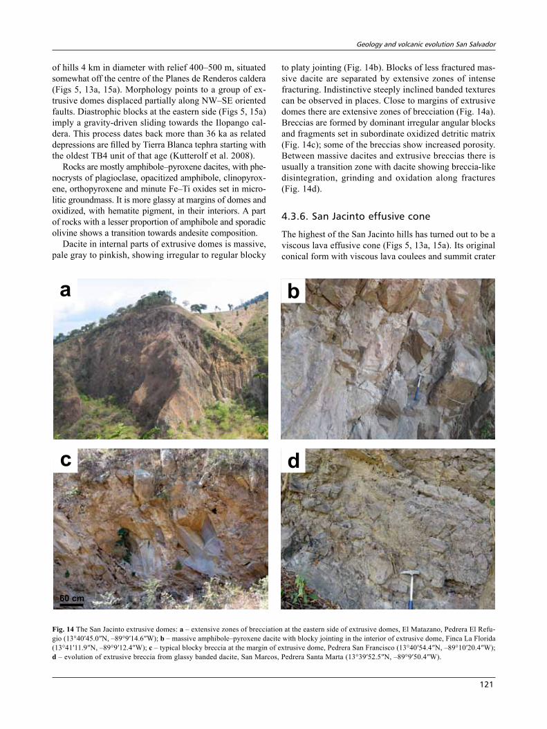
Rocks are mostly amphibole–pyroxene dacites, with phe-nocrysts of plagioclase, opacitized amphibole, clinopyrox-ene, orthopyroxene and minute Fe–Ti oxides set in micro-litic groundmass. It is more glassy at margins of domes and oxidized, with hematite pigment, in their interiors. A part of rocks with a lesser proportion of amphibole and sporadic olivine shows a transition towards andesite composition.
Dacite in internal parts of extrusive domes is massive, pale gray to pinkish, showing irregular to regular blocky
to platy jointing (Fig. 14b). Blocks of less fractured mas-sive dacite are separated by extensive zones of intense fracturing. Indistinctive steeply inclined banded textures can be observed in places. Close to margins of extrusive domes there are extensive zones of brecciation (Fig. 14a). Breccias are formed by dominant irregular angular blocks and fragments set in subordinate oxidized detritic matrix (Fig. 14c); some of the breccias show increased porosity. Between massive dacites and extrusive breccias there is usually a transition zone with dacite showing breccia-like disintegration, grinding and oxidation along fractures (Fig. 14d).
4.3.6. san Jacinto effusive cone
The highest of the San Jacinto hills has turned out to be a viscous lava effusive cone (Figs 5, 13a, 15a). Its original conical form with viscous lava coulees and summit crater
ba
c d
60 cm
Fig. 14 The San Jacinto extrusive domes: a – extensive zones of brecciation at the eastern side of extrusive domes, El Matazano, Pedrera El Refu-gio (13°40′45.0″N, –89°9′14.6″W); b – massive amphibole–pyroxene dacite with blocky jointing in the interior of extrusive dome, Finca La Florida (13°41′11.9″N, –89°9′12.4″W); c – typical blocky breccia at the margin of extrusive dome, Pedrera San Francisco (13°40′54.4″N, –89°10′20.4″W); d – evolution of extrusive breccia from glassy banded dacite, San Marcos, Pedrera Santa Marta (13°39′52.5″N, –89°9′50.4″W).
Jaroslav Lexa, Jiří Šebesta, José alexander Chavez, Walter hernández, zoltán Pécskay
122
is still well preserved (Fig. 15b). Outcrops in quarries along the base confirm the cone‘s internal structure. It consists of thick andesite lava flows showing periclinal
primary dips 25–35°. Individual flows are 10–25 m thick, with a high proportion of typical blocky breccias (Fig. 15c–d). Mutual relationships of lava flows in the
80 cm
e
ba
f
c d
Fig. 15 The San Jacinto effusive cone: a – view of the San Jacinto extrusive domes and effusive cone, Planes de Renderos caldera and Loma Lar-ga volcano from the east (Google Earth); b – palaeovolcanic reconstruction; c–d – steeply inclined silicic andesite lava flows with blocky breccia exposed in a quarry next to San Marcos (13°39′43.8″N, –89°10′41.2″W). San José tuff/scoria cone: e – alternating beds of dark scoria, pale tuffs and brownish dusty deposits in structure of the cone, road to Planes de Renderos (13°39′14.7″N, –89°11′48.1″W); f – detail of sorted scoria and tuff beds, note angularity of scoria fragments.
Geology and volcanic evolution san salvador
123
quarry at San Marcos indicate that they represent indi-vidual lobes of lava forming a more extensive and thicker coulee. Massive silicic andesite of lava flows is gray; with the increasing porosity and oxidation it acquires a brown-ish colour. Phenocrysts of plagioclase, clinopyroxene, or-thopyroxene, and Fe–Ti oxides rest in groundmass of the microlitic texture. The andesites contain mafic enclaves that imply a role of mafic magma injection and mixing in initiation of the volcanic eruption. The same phenomenon has been observed also in explosive products and dacite lavas of the Ilopango caldera (Richer et al. 2004).
4.3.7. san José scoria/tuff cone
The cone is exposed in road cuts NW of Planes de Rende-ros (Fig. 5). Its diametre is about 500 m. In the road cuts it shows periclinal dips 20–35° (Fig. 15e) that decrease to 10–20° at the foot of the former cone (Fig. 15f). The cone consists of alternating beds of sorted gray lapilli/scoria (0.5–3 cm), pale pumiceous tuffs and brownish dusty deposits corresponding to breaks in volcanic activ-ity. Andesite forming scoria is fairly mafic with very high contents of An-rich plagioclase, augite, amphibole, and Fe–Ti oxide phenocrysts. Groundmass shows microlitic texture. Pumice is probably of dacitic composition. An-gularity of scoria fragments points to phreatomagmatic component of explosive eruptions that in turn explains a higher degree of fragmentation characteristic of the Vul-canian type of eruptions. The cone rests on laterites atop of the Bálsamo Formation and its denudated remnants are covered by tephra of the Tierra Blanca 4 horizon.
4.3.8. antiguo Cuscatlán scoria cone
This newly discovered scoria cone makes up a small hill in Antiguo Cuscatlán (Fig. 5). The cone 400 m in diameter consists of coarse unsorted agglomerates/agglutinates (Fig. 16a–b). Size of irregular scoria fragments is 10–20 cm, rarely up to 0.5 m. Fine matrix is absent. Shape of scoria fragments and welding indicate that the cone was formed by the Hawaiian type eruptions. Rock of the cone is basaltic andesite with phenocrysts of plagioclase and clinopyroxene in groundmass of microlitic texture. Atop the cone there is a palaeosol covered by TB4 pumice tephra (Fig. 16a). The cone is situated on the same NW–SE trending fault-zone that connects the Boquerón volcano crater with the La Hoya scoria cone and the Plan de Laguna maar.
4.3.9. Older tephra deposits of the Ilopango/Coatepeque calderas
Plinian and Phreatoplinian eruptions associated with the evolution of the Ilopango and Coatepeque calderas
were a source for extensive tephra deposits (Williams and Meyer-Abich 1955; Pullinger 1998; Rose et al. 1999). While younger tephra deposits known as the Tierra Blanca and Arce/Congo horizons are assigned to the San Salvador Formation, older tephra deposits along with their reworked equivalents are grouped in this unit. Its boundary with the TB4 tephra horizon in the east is unquestionable (Fig. 18a). The boundary with the Arce/Congo tephra horizons in the west is less clear-cut owing to their lithological similarity. The unit of older tephra deposits does not form a continuous horizon. It rather occurs as local accumulations in tectonic and/or mor-phological depressions along the crest of the Cordillera del Bálsamo and the zone of diastrophic blocks between Cordillera del Bálsamo and Central Graben. Reworked facies appear especially at bottoms of valleys as remnants of their filling. Thickness of the older tephra deposits varies from a few to several tens of metres, reflecting a period of erosion, marked by unconformity, before de-position of the San Salvador Formation tephra horizons.
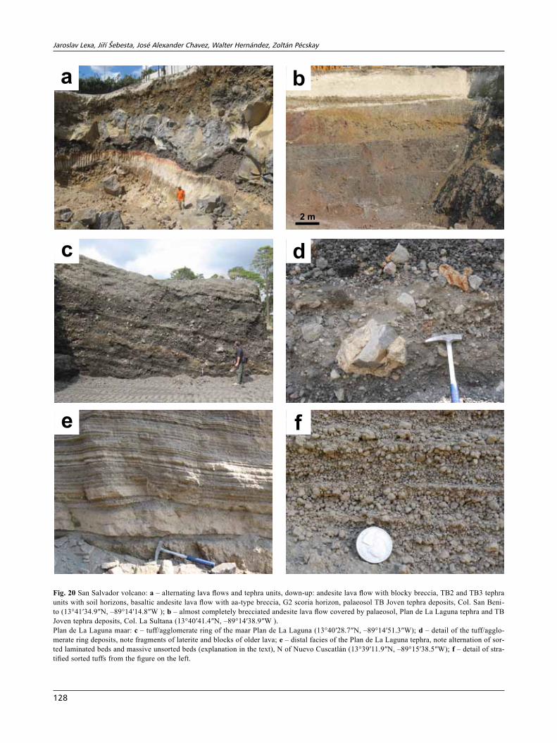
Tephra deposits related to the Ilopango caldera domi-nate in the eastern part of the study area. Mantle bedding, stratification and moderate to high degree of sorting point to prevailing medial zone fall-type deposits and subordi-nate horizons of dry pyroclastic surge deposits (Fig. 16c). Pumice flow type deposits have not been observed. Mate-rial is mostly pumice and ash with variable proportion of lithic fragments. Pumice/ash-rich horizons corresponding to the Plinian type eruptions alternate with horizons rich in angular glassy and lithic fragments and less vesiculated and angular pumice, pointing to the Phreatoplinian type of eruptions. The succession of tephra horizons includes several palaeosols, including brownish loess-like aeolian dust deposits. Their presence implies that inferior tephra deposits of the Ilopango caldera represent several cycles of the Phreatoplinian and Plinian type eruptions separated by breaks in activity lasting at least several thousands years. Hernández et al. (2010) assumed 8 such cycles.
Tephra deposits related to the Coatepeque caldera and Antiguo San Salvador volcano dominate in the western part of the study area. Pale pumice/ash type deposits alternate with pale gray andesitic tuffs and brownish pa-laeosols (Fig. 16d). In some sections aeolian deposits and palaeosols dominate over primary tephra deposits. Pri-mary tephra is sorted and stratified, representing mostly a distal facies of the Plinian fall-type deposits. Slightly argillized tephra deposits mostly rest on laterites atop the Bálsamo Formation, creating conditions for gravitational instability.
Freshly deposited tephra was a subject of immediate reworking. At the bottom of valleys among the dia-strophic blocks and in local morphological depressions there are remnants of mudflow, debris flow and hyper-concentrated flow deposits rich in pumice and ash with
Jaroslav Lexa, Jiří Šebesta, José alexander Chavez, Walter hernández, zoltán Pécskay
124
20 cm
e
ba
f
c d
Fig. 16 The Antiguo Cuscatlán scoria cone: a – contact of the scoria cone with overlying Tierra Blanca 4 (TB4) pumice tuffs, Antiguo Cuscatlán (13°39′59.1″N, –89°14′3.50″W); b – detail of coarse agglomerate/agglutinate making up the cone. Inferior tephra deposits of the Ilopango/Coa-tepeque calderas: c – well stratified and sorted tephra deposits with palaeosol horizons affected by faulting, note a cover of undeformed TB4 pu-mice tephra on the top of the outcrop, Colonia Vista Hermosa (13°40′38.2″N, –89°12′53.6″W); d – pre-TB4 tephra deposits with palaeosols next to Nuevo Cuscatlán (13°39′4.20″N, –89°15′29.2″W); e – mudflow/debris flow deposits rich in pumice among pre-TB4 tephra deposits including palaeosols W of Planes de Renderos (13°39′19.3″N, –89°13′4.60″W); f – detail of mudflow deposits with fragments of tuffs and fossil soil in ma-trix rich in pumice and ash, Río El Garrobo (13°40′16.7″N, –89°12′57.9″W).
Geology and volcanic evolution san salvador
125
fragments and blocks of underlying rocks, tuffs and fossil soils (Fig. 16e–f).
4.4. san salvador Formation
The youngest San Salvador Formation comprises in the study area a complex of tephra units of the Coatepeque and Ilopango calderas and San Salvador volcano (Rose et al. 1999). They rest either on laterites atop the Bál-samo Formation or remnants of the Cuscatlán Forma-tion. In the NW part of the study area (in the Central Graben) it includes also lava flows and lahars of the San Salvador stratovolcano interstratified with the tephra units (Fig. 17). Thickness of the formation varies from less than 0.5 m in the south and southwest to over 50 m close to the Ilopango caldera. Volcanostratigraphy of the Formation in the San Salvador area has been elaborated by Hernández (2004, 2008). With minor improvements based on newly published results of radiometric dating (Kutterolf et al. 2008; Dull et al. 2010; Hernández et al. 2010) it is reproduced in the Fig. 18. Individual tephra units are usually separated by palaeosols that associate often with brownish windblown dust deposits. Due to small thickness in the geological map (Fig. 5) individual members of the San Salvador Formation are not distin-guished with the exception of the Plan de Laguna maar and its tuff/scoria ring.
4.4.1. arce and Congo tephra units
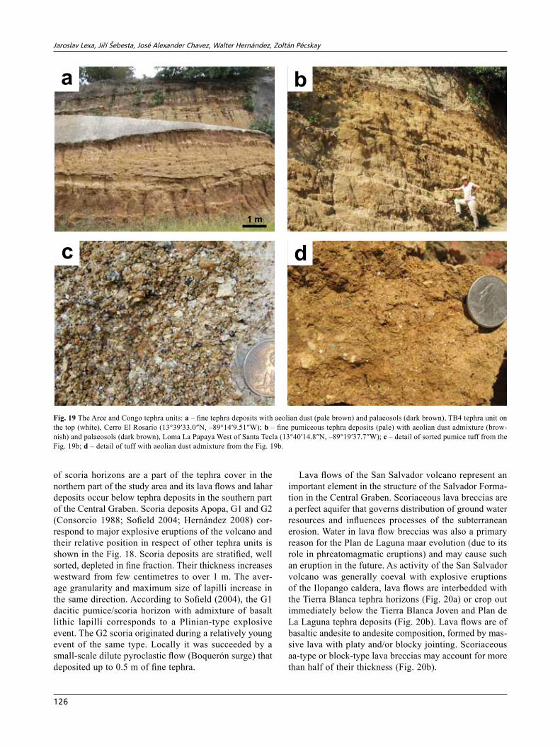
Arce and Congo tephra units are the two youngest of the three major Plinian type eruptions’ deposits of the Coatepeque caldera (Pullinger, 1998). In the northeastern part of the study area they occur sporadically and their thickness does not exceed 1 m. However, it increases to 20–30 m more to the W, at the ridge west of Santa Tecla (Fig. 19b). A period of erosion before deposition of the Tierra Blanca tephra marked by unconformity affected their thickness and areal extent. In the east, fine tephra deposits prevail over sorted pumice tuffs and brownish aeolian dusty deposits; palaeosols contribute signifi-cantly to the overall thickness (Fig. 19a). In the west, sorted pumice tuffs with admixture of lithic fragments (Fig. 19c) dominate over fine tuffs with aeolian dust admixture (Fig. 19d). Deposits corresponding to major eruption cycles are separated by palaeosols (Fig. 19a–b). All primary tephra deposits represent distal facies of Plinian fall-type deposits; deposits of pyroclastic surges and/or pumice flows have not been observed. At some horizons angularity of pumice fragments and the presence of glassy angular lithic fragments (Fig. 19c) point to the Phreatoplinian type of eruptions. Partial argillization has
affected the lowermost tephra deposits in the western part of the study area.
4.4.2. san salvador volcano
The San Salvador active volcano has not been a primary object of our study. However, its products in the form
Cordilleradel Bálsamo
Bálsamo Fm.
laterites
Cuscatlán Fm.
SS lava flow
Boquerón lava flow
Boquerónlava flow
Tierra BlancaJoven
PL – Plan de Laguna tuffs, CA – Congo and Arce tuff horizons, TB – Tierra Blanca horizons
PL
TB4
TB2-3
CA
faultzone
CentralGraben
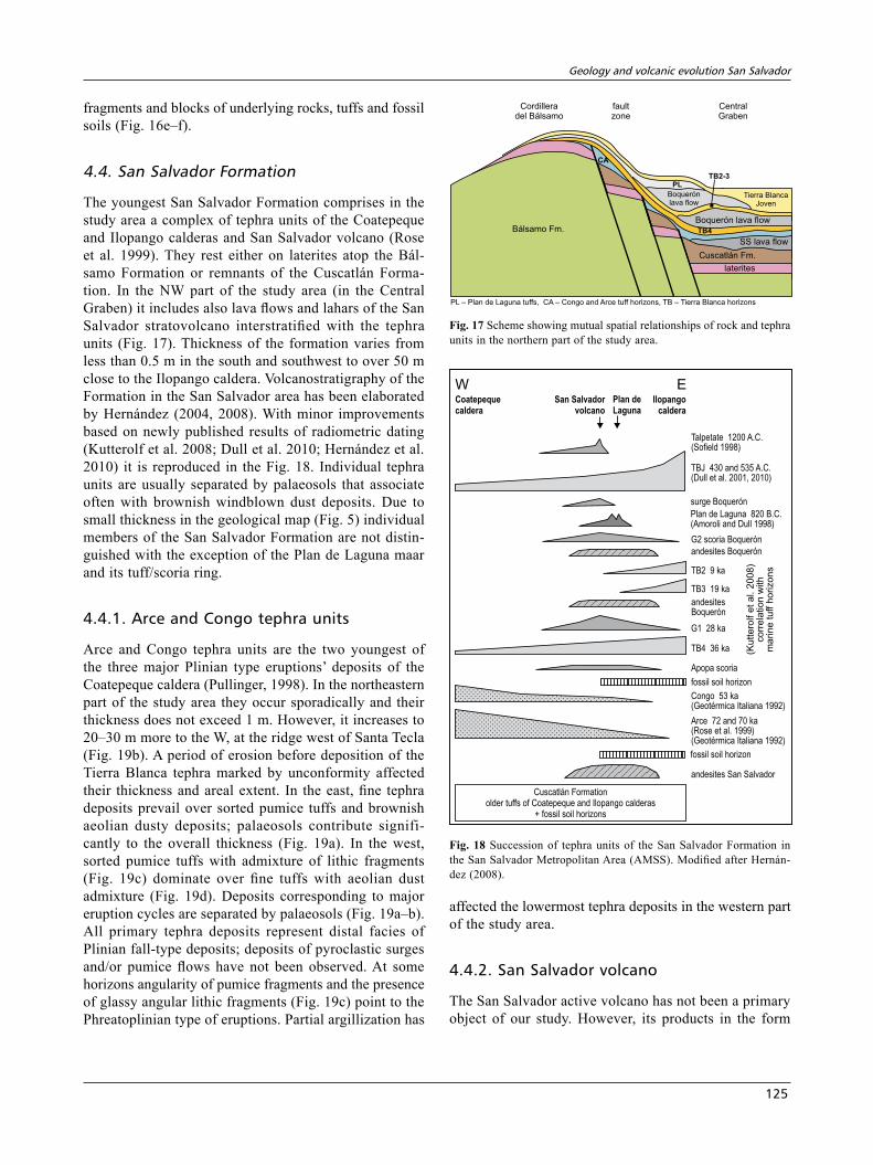
Fig. 17 Scheme showing mutual spatial relationships of rock and tephra units in the northern part of the study area.
W ECoatepeque
caldera
San Salvador
volcano
Plan de
Laguna
Ilopango
caldera
Talpetate 1200 A.C.(Sofield 1998)
TBJ 430 and 535 A.C.(Dull et al. 2001, 2010)
Plan de Laguna 820 B.C.(Amoroli and Dull 1998)
G2 scoria Boquerón
andesites Boquerón
andesitesBoquerón
surge Boquerón
TB2 9 ka
TB3 19 ka
G1 28 ka
TB4 36 ka
Apopa scoria
fossil soil horizon
Congo 53 ka(Geotérmica Italiana 1992)
Arce 72 and 70 ka(Rose et al. 1999)(Geotérmica Italiana 1992)
fossil soil horizon
andesites San Salvador
Cuscatlán Formationolder tuffs of Coatepeque and Ilopango calderas
+ fossil soil horizons
(Kuttero
lfetal.
2008)
corr
ela
tion
with
marine
tuff
horizons
Fig. 18 Succession of tephra units of the San Salvador Formation in the San Salvador Metropolitan Area (AMSS). Modified after Hernán-dez (2008).
Jaroslav Lexa, Jiří Šebesta, José alexander Chavez, Walter hernández, zoltán Pécskay
126
of scoria horizons are a part of the tephra cover in the northern part of the study area and its lava flows and lahar deposits occur below tephra deposits in the southern part of the Central Graben. Scoria deposits Apopa, G1 and G2 (Consorcio 1988; Sofield 2004; Hernández 2008) cor-respond to major explosive eruptions of the volcano and their relative position in respect of other tephra units is shown in the Fig. 18. Scoria deposits are stratified, well sorted, depleted in fine fraction. Their thickness increases westward from few centimetres to over 1 m. The aver-age granularity and maximum size of lapilli increase in the same direction. According to Sofield (2004), the G1 dacitic pumice/scoria horizon with admixture of basalt lithic lapilli corresponds to a Plinian-type explosive event. The G2 scoria originated during a relatively young event of the same type. Locally it was succeeded by a small-scale dilute pyroclastic flow (Boquerón surge) that deposited up to 0.5 m of fine tephra.
Lava flows of the San Salvador volcano represent an important element in the structure of the Salvador Forma-tion in the Central Graben. Scoriaceous lava breccias are a perfect aquifer that governs distribution of ground water resources and influences processes of the subterranean erosion. Water in lava flow breccias was also a primary reason for the Plan de Laguna maar evolution (due to its role in phreatomagmatic eruptions) and may cause such an eruption in the future. As activity of the San Salvador volcano was generally coeval with explosive eruptions of the Ilopango caldera, lava flows are interbedded with the Tierra Blanca tephra horizons (Fig. 20a) or crop out immediately below the Tierra Blanca Joven and Plan de La Laguna tephra deposits (Fig. 20b). Lava flows are of basaltic andesite to andesite composition, formed by mas-sive lava with platy and/or blocky jointing. Scoriaceous aa-type or block-type lava breccias may account for more than half of their thickness (Fig. 20b).
ba
c d
1 m
Fig. 19 The Arce and Congo tephra units: a – fine tephra deposits with aeolian dust (pale brown) and palaeosols (dark brown), TB4 tephra unit on the top (white), Cerro El Rosario (13°39′33.0″N, –89°14′9.51″W); b – fine pumiceous tephra deposits (pale) with aeolian dust admixture (brow-nish) and palaeosols (dark brown), Loma La Papaya West of Santa Tecla (13°40′14.8″N, –89°19′37.7″W); c – detail of sorted pumice tuff from the Fig. 19b; d – detail of tuff with aeolian dust admixture from the Fig. 19b.
Geology and volcanic evolution san salvador
127
4.4.3. Plan de La Laguna maar and tephra deposits
The Plan de La Laguna maar is well expressed in mor-phology (Fig. 4). It used to host a lake but later was filled by sediments and subsequently urbanized. The maar depression 750 m in diameter is surrounded by a ring (low and wide cone) of proximal facies phreatomagmatic deposits – pyroclastic breccias, agglomerates, and scoria (Fig. 20c). Stratification with periclinal dips around 15° reflects alternating beds of agglomerate rich in scoria and bombs and beds of pyroclastic breccia rich in blocks of older lava (Fig. 20d). Agglomerates consist of black aphanitic basalt vesiculated lapilli and bombs. Many of the bombs show cauliflower-like surface, a result of quenching at the contact with water. Pyroclastic breccias consist of blocks of massive lava and lava breccia, rare quenched bombs, rare fragments of fossil soil and/or laterite and fine ash-like matrix (Fig. 20d). In the south-ern part of the maar pyroclastic flow deposits have been observed at the bottom of the sequence. In the uppermost strata of the cone, phreatomagmatic deposits are replaced by common Strombolian-type scoria deposits.
Medial and distal facies tephra deposits show strongly asymmetric distribution in respect to the maar. Due to north-easterly wind at the time of the eruption they do not extend for more than 500 m in the NE direction and are thin. South-westward they reach almost as far as Zaragoza (11 km). Following the dispersal axis their thickness decreases. It is 8 m in the medial zone 1.3 km from the maar, 2 m in the distal zone 4 km from the maar and 0.5 m in the distal zone 8 km from the maar. In the same direction decreases the proportion of coarser beds and maximum size of lapilli. The medial and distal facies tephra is always well stratified and sorted with excep-tion of massive beds representing wet-surge deposits (Fig. 20e–f). Sorted beds show textures characteristic of the fall-type deposits and deposits of dry pyroclastic surges. Proportion of very fine dusty ash beds including accretionary lapilli increases with distance from the maar. Distal facies tephra deposits generally associate with the subjacent G2 scoria horizon covered by fossil soil and the superjacent TB Joven tephra horizon. Plan de La Laguna distal facies tephra is indurated owing to fast recrystal-lization of fine mafic ash.
Plan de La Laguna maar is situated on the NW–SE trending fault zone of the San Salvador volcano, where most of the flank eruptions took place (Fig. 4). Basaltic magma en route to the surface has encountered ground-water stored in breccias of the older San Salvador lava flows. This has initiated violent phreatomagmatic erup-tion giving rise to the maar and related tephra deposits. Accidental fragments in pyroclastic breccias are from the San Salvador volcano lava flows and not from the
subjacent Bálsamo Formation. Laterites atop the Bál-samo Formation were the lowermost rocks sampled by the explosive event. Once groundwater was exhausted, phreatomagmatic eruptions ceased to be taken over by the Strombolian type activity depositing the final scoria/lapilli horizon.
4.4.4. tierra blanca tephra deposits
The Tierra Blanca (TB) tephra deposits represent prod-ucts of the last four Phreatoplinian/Plinian explosive eruptions of the Ilopango caldera. In reality succession of tephra deposits includes palaeosols and horizons of the San Salvador volcano scoria and Plan de La Laguna tephra (Figs 18, 21). The Tierra Blanca tephra deposits show a great spatial variability as far as thickness and proportion of individual units are concerned. This vari-ability is a net result of primary deposition as well as an erosional removal. Tephra has accumulated as fall, pyroclastic surge and/or pumice flow type deposits. Fall type deposits show a regular pattern of primary isopachs with no respect to topography. The thickness decreases from up to 10 m close to Ilopango caldera to less than 1 m some 20 km away (Hernández 2004). Pyroclastic surge deposits to some extent respect the topography – they are thinner on ridges and thicker in depressions. Their average thickness is comparable with fall type deposits. Pumice flow deposits mimic the topography – they have accumulated only in depressions in great thickness. Their primary thickness varies from metres in the west (Fig. 21d) to 60 m close to the caldera (Fig. 21f) (Hernández 2004). Thickness of tephra in depressions (Panchimalco caldera, Planes de Renderos caldera, Santo Tomás close to Ilopango caldera) also increased owing to a syngenetic redeposition by floods. Subsequent erosion has removed loose tephra from ridges and slopes. Thus the present distribution of TB tephra deposits is as fol-lows (Fig. 5). (1) On southern slopes of the Cordillera del Bálsamo they are missing due to erosion except for local depressions around Panchimalco, Rosario de Mora, north of Huizúcar and west of Zaragoza. (2) Along the crest of the Cordillera del Bálsamo they are absent on steep ridges but preserved at the flat parts (not reached by relief rejuvenization) and in tectonic depressions. In the west, TB tephra units are interstratified with the San Salvador and Plan de La Laguna tephra units. (3) Thick TB tephra deposits accumulated primarily in the Central Graben owing to the presence of pumice flow deposits; they have not been removed by erosion yet. Thickness of TB tephra deposits increases eastward. At the west they are interstratified with the San Salvador tephra units and lava flows (Fig. 20a). (4) In the calderas Planes de Renderos as well as Santo Tomás and in the Panchimalco depression their greater thickness corresponds to the pres-
Jaroslav Lexa, Jiří Šebesta, José alexander Chavez, Walter hernández, zoltán Pécskay
128
e
ba
f
c d
2 m
Fig. 20 San Salvador volcano: a – alternating lava flows and tephra units, down-up: andesite lava flow with blocky breccia, TB2 and TB3 tephra units with soil horizons, basaltic andesite lava flow with aa-type breccia, G2 scoria horizon, palaeosol TB Joven tephra deposits, Col. San Beni-to (13°41′34.9″N, –89°14′14.8″W ); b – almost completely brecciated andesite lava flow covered by palaeosol, Plan de La Laguna tephra and TB Joven tephra deposits, Col. La Sultana (13°40′41.4″N, –89°14′38.9″W ).Plan de La Laguna maar: c – tuff/agglomerate ring of the maar Plan de La Laguna (13°40′28.7″N, –89°14′51.3″W); d – detail of the tuff/agglo-merate ring deposits, note fragments of laterite and blocks of older lava; e – distal facies of the Plan de La Laguna tephra, note alternation of sor-ted laminated beds and massive unsorted beds (explanation in the text), N of Nuevo Cuscatlán (13°39′11.9″N, –89°15′38.5″W); f – detail of stra-tified sorted tuffs from the figure on the left.
Geology and volcanic evolution san salvador
129
TBJ
TB3
TB4
A,B
B
soil
G2 scoria
C
C
D
D
E
A
soil
F
Cuscatlan Fm.
e
ba
f
c d
50 cm
Fig. 21 The Tierra Blanca tephra deposits: a – succession of Tierra Blanca tephra units separated by palaeosols at Santo Tomás (13°39′4.60″N, –89°8′54.4″W); b – detail: contact of the TB4 unit with underlying palaeosol; c – detail: pyroclastic surge and fall deposits of the TB3 unit; d – The TB Joven tephra unit above G2 scoria, see Fig. 22 for the explanation of symbols, San Benito (13°41′34.9″N, –89°14′14.8″W); e – detail at the lower part of the TB Joven unit, see Fig. 22 for the explanation of symbols, Cerro El Candelero (13°36′40.3″N, –89°11′38.0″W); f – Tierra Blan-ca Joven: thick pumice flow deposits of the subunit F, southern edge of Ilopango (13°41′20.8″N, –89°6′37.4″W).
Jaroslav Lexa, Jiří Šebesta, José alexander Chavez, Walter hernández, zoltán Pécskay
130
ence of pumice flow deposits along with pumice tuffs reworked due to syngenetic remobilization. (5) Close to the Ilopango caldera their thickness is around 60 m. Pumice flow deposits as well as reworked tuffs (Fig. 23) contribute to the great thickness. The TB tephra deposits are divided into four units: TB4, TB3, TB2, and TB Joven separated by palaeosols (Figs 18, 21a) (Consorcio 1988).
The TB4 tephra unit is of rhyolitic composition. Its thickness close to the caldera reaches 7 m and gradu-ally decreases westward to roughly 3 m at Santa Tecla (Hernández et al. 2010). It was often strongly modified or even completely removed by subsequent erosion (ridges of Cordilera Bálsamo). The Consorcio (1988) estimated the original volume of the unit to more than 20 km3 (DRE – dry rock equivalent). The unit consists of moderately sorted coarse pumice fall deposits with thin layers of fine ash at the bottom and top (Fig. 21b). The juvenile fragments of larger size are typically elongated and flat which, during the eruption, mostly landed sub-horizontally producing pseudo-stratification. Close to the source (< 3–4 km), pumice has average size ~1 cm with maximum of 5 cm. With increasing distance, 8–12 km from the source, pumice size decreases to an average of 0.5 cm and maximum of 2 cm. The pumice fall deposits lack the characteristic stratification. This is explained by uninterrupted deposition of the uniform size particles. Rarely are present mafic enclaves implying that injec-tion of mafic magma into differentiated magma chamber probably triggered the eruption (Hernández et al. 2010).
The TB3 tephra unit represents products of a relatively small Phreatoplinian type eruption. It consists of fine ash deposits with variable quantities of accretionary lapilli and fine to coarse pyroclastic surge deposits (Fig 21c). Rare small lithic fragments are present besides common pumice of dacite composition. In the distal zone pumice fall deposits with ash fall deposits at the base are pres-ent. Consorcio (1988) estimated volume of this unit to 1–5 km3 (DRE).
The TB2 tephra unit originated during a minor Phre-atoplinian eruption. It consists of poorly sorted beige to white dacite pumice fall deposits with abundant crystalloclasts of amphibole, pyroxene, magnetite and plagioclase as well as intercalations of fine pyroclastic surge/fall deposits. At the distal zone only the pumice fall deposits are present. Consorcio (1988) estimated volume of the unit to 1–5 km3 (DRE). Similarly to the TB4 unit, there are present fragments implying the phenomena of mafic–felsic magma mixing.
The TB Joven tephra unit is the youngest (A.C. 429 ± 107 after Dull et al. 2001, A.C. 535 after Dull et al. 2010) and the most voluminous one. Ejected material covered an area of 300, 000 km2 and its volume is estimated at 70 km3 (DRE) (Kutterolf et al. 2008). This was a cata-clysmic eruption, one of the most destructive in Central
America (Rolo et al. 2004). In addition to widespread fall type deposits, a large volume of pumice flow deposits ac-cumulated in depressions closer to the Ilopango caldera (up to 37 km away). The maximum thickness measured is 60 m near the Las Cañas river basin. These deposits are characterized by being white soft and easily erodible, generating badlands type scarps (Šebesta 2007). Most of the metropolitan area (AMSS) has been built on tephra deposits of the TB Joven tephra unit. It is composed of seven subunits with variable physical characteristics related to the distinct eruptive mechanisms (Hernández 2004). Going upwards, we distinguish (Figs 21d, f, 22):
G
A
B
C
D
E
F
mostly fine tuffswith accretionarylapilli – co-ignimbritecloud deposits
fine to coarse tuffs– stratified falland dry surgedeposits
sorted pumice tuffsPlinian fall deposits
phreatomagmaticfall type deposits
Fig. 22 Subdivision of the Tierra Blanca Joven tephra unit (after Her-nández 2004).
Geology and volcanic evolution san salvador
131
(A) initial sorted phreatomagmatic fall type deposits up to 10 cm thick; (B) c. 10 cm of moderately sorted Plinian fall type pumice deposits; (C) moderately sorted stratified/laminated dry pyroclastic surge deposits with interbedded fall type deposits (≤ 50 cm); (D) unsorted fine ash and pumice deposits with accretionary lapilli (≤ 1 m); (E) moderately sorted dry surge deposits with unsorted beds of wet surge deposits (≤ 40 cm); (F) cha-otic unsorted pumice flow deposits of variable thickness from less the 1 m at elevations 8–12 km away from the caldera to 30–50 m next to the source; (G) unsorted or poorly sorted fine tuffs with accretionary lapilli – co-ignimbrite pyroclastic surge/fall type deposits.
Close to the Ilopango lake, along the rivers Río La Jutera, Río Chagüite, Río Cuapa, and tributaries, there is a subhorizontally laying stratified succession of moderately to well sorted reworked pumice tuffs and tuffs below thick pumice flow deposits of the TB Joven – unit F (Fig. 23). Its thickness exceeds 20 m, base is
not exposed. Bosse et al. (1978) assigned this succes-sion to the youngest part of the Cuscatlán Formation. However, there are several points/arguments that place this succession among the Tierra Blanca tephra units, most probably to the early stages of the Tierra Blanca Joven unit: (1) missing subunits A–E below the subunit F of the TB Joven tephra unit; (2) continuous succession of beds without any signs of interruption of depositional processes (Fig. 23a–b) and resemblance of material in reworked tuffs and overlying pumice flow deposits (Fig. 23b); (3) no evidence of erosion of the reworked tuffs before deposition of the pumice flows – reworked tuffs and pumice flow deposits show a concordant relationship over a large area; (4) missing palaeosol on the top of the reworked tuff succession corresponding to the break in volcanic activity as palaeosols separate tephra units elsewhere (Figs 19a, 21a).
Most of the succession of reworked tuffs consists of well stratified and sorted pumice and ash-rich deposits
ba
c d
40 cm
Fig. 23 The Tierra Blanca reworked facies: a – contact of stratified, moderately sorted reworked pumice tuffs with overlying pumice flow depo-sits, Río Chagüite (13°41′4.44″N, –89°7′7.85″W); b – moderately sorted reworked pumice tuffs below pumice flow deposits showing low ang-le inclined bedding, Río La Jutera (13°41′28.8″N, –89°6′11.3″W); c – succession of well stratified, sorted reworked pumice tuffs showing lateral wedging-out of strata, Río La Jutera (13°41′29.5″N, –89°6′8.81″W); d – detail of deposits on the Fig. 23b showing rounding of pumice fragments.
Jaroslav Lexa, Jiří Šebesta, José alexander Chavez, Walter hernández, zoltán Pécskay
132
(Fig. 23). Thicker beds of coarse tuffs with a variable lithic fragments admixture alternate with relatively thin fine-grained beds and thin horizons of laminated silty deposits (Fig. 23c). Pumice fragments show often a higher degree of rounding (Fig. 23d). Observed textures include low-angle inclined bedding, convolute deforma-tion of fine-grained and silty beds, drag deformation of silty deposits underneath coarse beds, reverse grading of pumice-rich beds, separation of pumice and lithic frag-ments, lamination of coarser beds, rare bigger fragments in otherwise medium or fine grained beds. The observed textures correspond to prevailing deposition by debris and hyperconcentrated flows (floods) on a flat alluvial plain, alternating with deposition of silty material from almost standing water. Rare thick beds of epiclastic breccias formed of andesite–dacite angular fragments in pumice/ash-rich matrix represent mudflow deposits. We interpret the succession of reworked tuffs as syngenetic with early stages of the TB Joven Phreatoplinian/Plinian explosive eruption due to a coeval extensive precipitation. Re-
worked material was laid down on the alluvial plain next to Ilopango lake that – owing to a fast accumulation of material – prograded probably into the lake as delta. Flat top of the reworked tuff succession reflects lake‘s water level at that time.
4.5. Laterites and their extent
Chemical weathering in tropical climatic conditions of El Salvador resulted in formation of laterites (Fig. 24). As their evolution requires a long time, c. 1 m. y. or more (Tardy 1997), they are developed on rocks of the Bálsamo Formation, especially atop rocks of the older Panchi-malco stratovolcano. Thickness of laterites is usually few metres, however, it can reach over 10 m locally. At their base there is a zone of partially weathered rocks. Later-itic weathering has affected also younger formations but laterites have not yet developed and reddish lateritic soils formed instead. Laterites are present only in those parts of the study area where they have not been removed by
ba
c d
Fig. 24 Laterites: a – a thick cover of laterites atop the Bálsamo Formation, Finca La Marina (13°36′43.7″N, –89°12′52.0″W; b – laterite with residual blocks of unweathered andesite, Lot. Las Alturas (13°38′16.5″N, –89°13′23.9″W); c – close up of laterite evolved from andesite lava, Loma San José (13°38′11.1″N, –89°14′14.5″W); d – detail of laterite on the Fig. 24a evolved from epiclastic breccia.
Geology and volcanic evolution san salvador
133
retrograde erosion related to the rejuvenization of relief. It followed the Early Quaternary uplift of the Cordil-lera del Bálsamo – along the crest of the Cordillera del Bálsamo and in the Central Graben marginal fault zone with related diastrophic blocks. In these areas laterites are preserved mostly with a cover of younger tephra (Congo/Arce, Tierra Blanca, Plan de Laguna and San Salvador) (Fig. 5). During the dry period of the year laterites are strong and competent. However, during the long last-ing rainy season they get wet, plastic and incompetent. Quality of laterites is variable, reflecting lithology and composition of the source. Laterites are richer in Fe-, Al-, Ti- and Mn-bearing secondary minerals and include less residual material if developed from mafic lava (Fig. 24c) compared to weathering of more silicic epiclastic volca-nic rocks (Fig. 24d). They are rich in limonite, goethite, hematite, gibbsite, boehmite, anatase, pyrolusite, manga-nite, halloysite, kaolinite, allophane, and quartz (Tardy 1997). In our case XRD has confirmed the presence of kaolinite (halloysite), smectite and illite/smectite mixed layer clay minerals.
4.6. Few notes on the Ilopango volcanic complex
We are using the term Ilopango volcanic complex for remnants of an extensive compound andesite stratovol-cano east of the study area hosting the Ilopango caldera (Fig. 4). We have not carried out in its domain any sys-tematic field work. However, we have collected 7 samples from different units of the complex for K–Ar dating in order to complement the picture of volcanic evolution of the area. It is evident from the analysis of morphology and geological map (Bosse et al. 1978) that the complex represents a succession of superimposed volcanic struc-tures, the Ilopango caldera being the youngest one. Tak-ing into account field relationships and results of K–Ar dating we propose the following succession (Fig. 25):
(1) the Bálsamo Formation represented by remnants of andesite stratovolcano with the central zone in the area of the Ilopango caldera – we propose to name it as “Anti-guo Ilopango stratovolcano”; (2) the Ilopango ignimbrites of the Cuscatlán Formation (an analogue to the Jayaque ignimbrites) related to the Antiguo Ilopango caldera; (3) a basaltic andesite effusive volcano with the central zone in the area of the Ilopango caldera – we propose the name “Ilopango volcano”; (4) evolution of the Ilopango caldera associated with silicic extrusive dome emplacement, first at the rim, later on the floor and Phreatoplinian/Plinian explosive eruptions (Mann 2003).
5. Volcanic evolution of the area
There are published radiometric data available concern-ing ages of the San Salvador Fm. tephra units (Fig. 18) but the radiometric ages of the Bálsamo and Cuscatlán formations in El Salvador have been missing so far. The ages are based solely on the correlation of volcanic for-mations across the northern Central America (Reynolds 1980) and on the analogy with the SE Guatemala (Reyn-olds 1987). Therefore, we have dated 30 samples of the Bálsamo and Cuscatlán formations using the conventional K–Ar method.
5.1. results of radiometric dating
Dated samples are localized in the Fig. 5 (except those from the Ilopango volcanic complex). The Tab. 1 pro-vides their GPS coordinates, assignment of samples to volcanic units (formations and members), type of geo-logical object dated, petrographic type of analyzed rock, and dated fraction/material.
Samples of fresh rocks having mass of 300–500 g were crushed, sieved to fraction 0.3–0.1 mm, washed to remove fine dust and dried. No further treatment was ap-
Ilopango caldera
?
?
Ilopango volcano
rim dome
floor domeCerros
Quemados
TB eq. = Tierra Blanca equivalents
TB eq.
Antiguo Ilopango stratovolcano
Ilopango ignimbrites
N S
lake
Fig. 25 Scheme of succession/superposition of volcanic units in the Ilopango Volcanic Complex.
Jaroslav Lexa, Jiří Šebesta, José alexander Chavez, Walter hernández, zoltán Pécskay
134
plied in the case of whole-rock dating. The groundmass fraction was separated by permanent magnet. At first was extracted the fraction rich in magnetite using a weak magnet. Then remaining groundmass was separated from phenocrysts of pyroxene and plagioclase by a stronger magnet. Purity of collected groundmass fractions varied in the range 70–90 %.
Dating of the groundmass fraction eliminates more or less the problem of possible excess 40Arrad in potassium-poor phenocrysts that might be serious in the case of very young rocks. Groundmass is usually richer in potassium than whole rock and in that way increases precision of K–Ar analyses. However, matrix of ignimbrites contains often minute lithic fragments of older rocks. Dating of ignimbrite as a whole rock or its matrix can provide false results, usable as maximum ages only. In order to avoid this problem in such cases we have dated separated ju-venile pumice fragments or glassy fiamme.
Potassium contents were determined in 0.05 g of fine sample powders digested in hydrochloric and nitric acids and finally taken to 0.2M HCl. Potassium was determined by flame photometry with a Na buffer and Li internal standard. Based on inter-laboratory standards Asia 1/65 LP-6 HD-B1 and GL-O relative analytical error of potas-sium determination is 2 %. Argon was extracted by radio frequency fusion in Mo crucibles in previously baked out stainless steel vacuum system. Pure 38Ar spike was added from gas pipette system and the released gases cleaned using Ti-sponge with SAES St707 pills getters and liquid nitrogen traps respectively. The purified Ar was trans-ported directly into a 15 cm radius magnetic sector type mass spectrometer built in Debrecen. Argon isotope ratio was measured in the static mode. Based on calibration of the gas pipette using international standards, the relative analytical error of 38Ar spike is 2 %. Based on repeated measurements (long-time stability of the instrument) the relative analytical errors of 40Ar/38Ar and 36Ar/38Ar isotope ratios determination are 1 %. Age of the sample has been calculated using the decay constants suggested by Steiger and Jäger (1977) and isotopic composition of natural po-tassium 39K – 93.2581 % 40K – 0.01167 % 41K – 6.7302 %. Analytical error is given at 68% confidence level (1σ) using the equation of Cox and Dalrymple (1967). Details of analytical procedures have been published elsewhere (Odin et al. 1982; Balogh 1985).
Altogether, 35 analyses have been performed on 30 samples. Results are given in the Tab. 1. With excep-tion of 3 results, eliminated from further consideration due to inconsistency, the ages are consistent and depend-able. The lower relative precision of the youngest results reflects the proximity to the detection limit. Intervals of analytical results and likely time spans for the individual geological units are given in the Tab. 2. The probable age intervals are based on visual evaluation of normal
distribution density curves (sums of normal distribution density curves of individual samples given by age and error). Succession of geological units with the probable age intervals is shown in the Fig. 26.
5.2. evolution of volcanic activity
During the Late Miocene time the volcanic arc axis migrated closer to the trench, roughly into its present position (Reynolds 1987; Mann 2007). In the study area and surroundings, volcanic activity of the CAVF in its new position started already during the Late Miocene by formation of the extensive basaltic andesite–andesite Panchimalco stratovolcano representing the Bálsamo Formation. We have no evidence for continuation of the Bálsamo Formation volcanic activity during most of Pliocene. Perhaps, the Antiguo Ilopango stratovolcano or some other volcanoes outside of the study area were erupting during this time interval. Volcanic activity of the Bálsamo Formation in the study area was concluded by formation of very extensive basaltic andesite–andesite Jayaque stratovolcano during the Late Pliocene–Early Pleistocene time.
0Ma
4
2
6
8
1
5
3
7
San Salvador
Fm.
Bálsamo
Formation
Cuscatlán
Formation
Ilopango volcano
Loma Larga volcano
San Jacinto domes and cone
Early Ilopango caldera domes and tuffs
SS volcano, Arce/Congo, Tierra Blanca 1–4, Plan de Laguna maar
Ilopango ignimbrites
Jayaque ignimbrites
Jayaque stratovolcano
Panchimalco stratovolcano
Antiguo Ilopango stratovolcano ?
Fig. 26 Succession and probable ages of distinguished geological units. Differences in ages of individual units on the left and right sides of the diagram reflect uncertainties in their ages. Note the change in the age scale at 1 Ma.
Geology and volcanic evolution san salvador
135
Tab.
1 R
esul
ts o
f K–A
r dat
ing
of ro
cks
from
the
Bál
sam
o an
d C
usca
tlán
form
atio
ns
sam
ple
coor
dina
tes
(WG
S84)
loca
lity
unit
geol
ogy
rock
date
d fr
actio
nag
eer
ror
(1σ)
SS-0
0413
° 38
' 48.
4"–8
9° 1
4' 4
0.0"
S of
St.
Elen
aB
álsa
mo
– Ja
yaqu
e
volc
ano
lava
flow
; mas
sive
and
esite
sho
win
g bl
ocky
join
ting
two-
pyro
xene
and
esite
with
mic
ro-
litic
gro
undm
ass
w.r.
1.98
0.09
gdm
2.42
0.10
SS-0
0513
° 38
' 27.
6"–8
9° 1
6' 5
1.6"
W o
f Nue
vo
Cus
catlá
nB
álsa
mo
– Ja
yaqu
e
volc
ano
bloc
k in
epi
clas
tic b
recc
iatw
o-py
roxe
ne a
ndes
itegd
m1.
890.
10
SS-0
0913
° 36
' 16.
1"–8
9° 1
7' 0
9.6"
N o
f Zar
agoz
aJa
yaqu
e ig
nim
brite
sig
nim
brite
uni
t sho
win
g in
cipi
ent c
o-lu
mna
r joi
ntin
gm
oder
atel
y w
elde
d an
desi
tic ig
nim
-br
ite w
ith b
lack
fiam
me
w.r.
<2.4
10.
27
SS-0
1713
° 40
' 13.
6"–8
9° 1
9' 2
2.8"
W o
f Nue
vo S
an
Salv
ador
Bál
sam
o –
Jaya
que
volc
ano
lava
flow
; slig
htly
por
ous
show
ing
irreg
ular
blo
cky
join
ting
ande
site
poo
r in
pyro
xene
with
m
icro
litic
gro
undm
ass
w.r.
1.74
0.20
gdm
1.83
0.20
SS-0
2013
° 39
' 14.
6"–8
9° 1
5' 3
9.0"
Nue
vo C
usca
tlán
Jaya
que
igni
mbr
ites
igni
mbr
ite u
nit
pale
slig
htly
wel
ded
daci
tic?
ig
nim
brite
pum
ice
only
1.53
0.07
SS-0
4413
° 36
' 03.
6"–8
9° 1
1' 2
6.4"
SW o
f Pan
chim
alco
Bál
sam
o –
Panc
him
alco
vo
lcan
oth
ick
lava
flow
; mas
sive
and
esite
sh
owin
g co
lum
nar j
oint
ing
ande
site
poo
r in
phen
ocry
sts,
mic
rolit
ic g
roun
dmas
sw
.r.8.
020.
26
gdm
7.10
0.23
SS-0
4613
° 37
' 31.
8"–8
9° 1
1' 2
3.1"
Puer
ta d
el D
iabl
oB
álsa
mo
– Pa
nchi
mal
co
volc
ano
lava
flow
; mas
sive
and
esite
sho
win
g pl
aty
join
ting
pyro
xene
and
esite
rich
in p
he-
nocr
ysts
, mic
rolit
ic g
dmw
.r.6.
300.
25
gdm
5.13
0.24
SS-0
5513
° 39
' 15.
0"–8
9° 0
9' 2
3.5"
E of
San
Mar
cos
Lom
a La
rga
volc
ano
thin
lava
flow
; por
ous
ande
site
sh
owin
g pl
aty
join
ting
porp
hyrit
ic b
asal
tic a
ndes
ite w
ith
mic
rolit
ic g
roun
dmas
sw
.r.0.
490.
33
SS-0
7313
° 39
' 47.
4"–8
9° 1
0' 4
2.7"
San
Mar
cos
San
Jaci
nto
– vo
lca-
nic
cone
thic
k la
va fl
ow; m
assi
ve d
acite
sh
owin
g irr
egul
ar b
lock
y jo
intin
gtw
o-py
roxe
ne a
ndes
ite w
ith g
lass
y m
icro
litic
gro
undm
ass
w.r.
0.27
0.17
gdm
0.33
0.23
SS-1
5113
° 39
' 09.
2"–8
9° 1
1' 2
0.3"
N o
f Pla
nes
de
Ren
dero
sLo
ma
Larg
a vo
lcan
ola
va fl
ow; m
assi
ve a
ndes
ite s
how
ing
bloc
ky jo
intin
gph
enoc
ryst
-poo
r bas
altic
and
esite
gl
assy
mic
rolit
ic g
dmw
.r.0.
900.
36
SS-1
6613
° 39
' 52.
3"–8
9° 0
9' 4
9.2"
NE
of S
an M
arco
sSa
n Ja
cint
o –
extru
si-
ve d
ome
mar
gina
l par
t of e
xtru
sive
dom
e sh
owin
g br
ecci
a te
xtur
epy
roxe
ne–a
mph
ibol
e da
cite
mic
ro-
litic
/fels
itic
grou
ndm
ass
w.r.
0.36
0.04
0
SS-1
7813
° 41
' 00.
8"–8
9° 0
9' 4
2.8"
S of
Ciu
dad
Cre
disa
San
Jaci
nto
– ex
trusi
-ve
dom
em
argi
nal p
art o
f ext
rusi
ve d
ome
show
ing
brec
cia
text
ure
pyro
xene
–am
phib
ole
daci
te m
icro
-lit
ic g
roun
dmas
sw
.r.0.
340.
066
SS-1
9313
° 38
' 00.
5"–8
9° 1
4' 1
5.4"
San
José
A
guac
atitá
nB
álsa
mo
– Ja
yaqu
e
volc
ano
lava
flow
; mas
sive
and
esite
sho
win
g bl
ocky
to p
laty
join
ting
pyro
xene
-poo
r and
esite
gdm
2.44
0.14
SS-2
1013
° 35
' 48.
7"–8
9° 1
4' 0
2.4"
N o
f Hui
zúca
rJa
yaqu
e ig
nim
brite
sst
rong
ly w
elde
d ig
nim
brite
uni
tpy
roxe
ne-p
oor a
ndes
itegl
ass
1.35
0.07
5
SS-2
1113
° 35
' 45.
9"–8
9° 1
4' 0
8.4"
N o
f Hui
zúca
rB
álsa
mo
– Pa
nchi
mal
co
volc
ano
lava
flow
; mas
sive
to v
esic
ular
and
e-si
te s
how
ing
bloc
ky jo
intin
gpo
rphy
ritic
pyr
oxen
e–am
phib
o-le
and
esite
w.r.
6.80
0.30
1 max
imum
age
due
to a
pos
sibl
e co
ntam
inat
ion;
2 pro
babl
e ex
cess
radi
ogen
ic A
r – th
e gr
ound
mas
s ag
e is
pre
ferr
ed; 3 p
ossi
ble
radi
ogen
ic A
r los
s –
the
who
le-r
ock
age
is p
refe
rred
Ana
lyse
s by
Zol
tán
Pécs
kay,
ATO
MK
I, D
ebre
cen,
Hun
gary
; dat
ed fr
actio
n/m
ater
ial:
w.r.
– w
hole
rock
, gdm
– g
roun
dmas
s
Jaroslav Lexa, Jiří Šebesta, José alexander Chavez, Walter hernández, zoltán Pécskay
136
Tab.
1 (C
ont.)
sam
ple
coor
dina
tes
(WG
S84)
loca
lity
unit
geol
ogy
rock
date
d fr
actio
nag
eer
ror
(1σ)
SS-2
8813
° 39
' 59.
1"–8
9° 1
4' 3
.5"
SW o
f Ant
iguo
Cus
-ca
tlán
Ant
iguo
Cus
catlá
n
scor
ia c
one
scor
ia/a
gglu
tinat
e co
ne w
ith b
ombs
up
to 3
0 cm
acr
oss
porp
hyrit
ic p
yrox
ene
ande
site
gdm
0.12
0.13
SS-3
1013
° 42
' 16.
0"–8
9° 0
3' 4
9.5"
Apa
ncin
o Lo
ma
Cin
-co
Tiro
sIlo
pang
o –
extru
sive
do
me
brec
ciat
ed m
argi
nal p
art o
f ext
rusi
-ve
dom
egl
assy
por
phyr
itic
daci
tegl
assy
gd
m0.
060.
029
SS-3
3213
° 40
' 22.
6"–8
9° 1
2' 2
4.8"
Rio
El G
arro
boLo
ma
Larg
a vo
lcan
ola
va fl
ow; m
assi
ve to
ves
icul
ar b
asal
-tic
and
esite
with
blo
cky
join
ting
basa
ltic
ande
site
gdm
0.68
0.07
0
SS-3
6213
° 38
' 47.
4"–8
9° 1
0' 1
8.3"
S of
San
Mar
cos
Lom
a La
rga
volc
ano
lava
flow
; mas
sive
and
esite
with
pl
aty
join
ting
basa
ltic?
and
esite
gdm
0.64
0.27
SS-5
5413
° 36
' 23.
7"–8
9° 0
9' 2
3.4"
Joya
s de
Giró
nLo
ma
Larg
a vo
lcan
oin
tra-c
anyo
n la
va fl
ow; m
assi
ve
ande
site
with
blo
cky
join
ting
porp
hyrit
ic p
yrox
ene
ande
site
gdm
0.35
0.50
SS-5
9113
° 35
' 59.
2"–8
9° 1
0' 0
6.6"
El C
hum
elo
Bál
sam
o –
Panc
him
alco
vo
lcan
ola
va fl
ow; m
assi
ve a
ndes
ite w
ith
plat
y jo
intin
gba
salti
c? a
ndes
itegd
m6.
300.
22
SS-6
7313
° 34
' 05.
4"–8
9° 1
2' 5
9.8"
SW o
f Ros
ario
de
Mor
aJa
yaqu
e ig
nim
brite
sst
rong
ly w
elde
d ig
nim
brite
uni
t with
co
lum
nar j
oint
ing
dark
stro
ngly
wel
ded
glas
sy
igni
mbr
ite w
ith b
lack
fiam
me
glas
s1.
410.
18
SS-8
2913
° 40
' 46.
0"–8
9° 1
9' 5
5.0"
ENE
of L
os A
mat
esB
álsa
mo
– Ja
yaqu
e
volc
ano
lava
flow
; mas
sive
dac
ite w
ith b
lock
y to
pla
ty jo
intin
gpy
roxe
ne a
ndes
itegd
m2.
490.
20
SS-8
6813
° 37
' 35.
4"–8
9° 1
9' 2
5.5"
Lom
a de
San
ta E
lena
Bál
sam
o –
Jaya
que
vo
lcan
ola
va fl
ow; m
assi
ve a
ndes
ite w
ith
bloc
ky jo
intin
gpo
rphy
ritic
pyr
oxen
e an
desi
tegd
m1.
450.
09
SS-8
9313
° 37
' 20.
7"–8
9° 0
4' 1
6.5"
Lom
as d
e C
ande
laria
Bál
sam
o –
Ilopa
ngo
volc
ano
lava
flow
; mas
sive
and
esite
with
bl
ocky
join
ting
porp
hyrit
ic p
yrox
ene
ande
site
gdm
1.00
0.31
SS-8
9813
° 37
' 14.
6"–8
9° 0
2' 0
8.3"
Cer
ro T
epeu
loIlo
pang
o –
extru
sive
do
me
mar
gina
l par
t of e
xtru
sive
dom
e sh
owin
g br
ecci
a te
xtur
epo
rphy
ritic
gla
ssy
daci
tegl
assy
gd
m0.
180.
088
SS-8
9913
° 37
' 09.
6"–8
9° 0
1' 5
2.2"
Cer
ro M
iram
arB
álsa
mo
– Ilo
pang
o vo
lcan
ola
va fl
ow; m
assi
ve a
ndes
ite w
ith
bloc
ky to
pla
ty jo
intin
gpo
rphy
ritic
pyr
oxen
e an
desi
tegd
m1.
440.
14
SS-9
0113
° 38
' 31.
9"–8
9° 0
1' 1
7.9"
Cer
ro E
l Mon
oIlo
pang
o –
extru
sive
do
me
glas
sy b
lock
in e
xtru
sive
bre
ccia
at
extru
sive
dom
e m
argi
npo
rphy
ritic
gla
ssy
daci
tegl
ass
0.08
0.02
8
SS-9
6513
° 31
' 18.
8"–8
9° 0
5' 1
1.7"
San
Juan
Tal
pa –
Lo
ma
La T
alpu
jaIlo
pang
o ig
nim
brite
ssl
ight
ly w
elde
d ig
nim
brite
uni
tun
sorte
d pu
mic
e tu
ff o
f pin
k co
lour
w
ith w
hite
pum
ice
pum
ice
only
1.81
0.22
SS-9
6613
° 30
' 47.
9"–8
9° 0
5' 4
8.7"
Las
Pied
ritas
Ilopa
ngo
igni
mbr
ites
mod
erat
ely
wel
ded
igni
mbr
ite u
nit
show
ing
bloc
ky jo
intin
gw
elde
d pu
mic
e tu
ff w
ith re
ddis
h m
atrix
wel
ded
pum
ice
1.77
0.22
Geology and volcanic evolution san salvador
137
Activity of intermediate–silicic caldera volcanoes characteristic of the Cuscatlán Formation (Reynolds 1980, 1987) commenced during the Early Pleistocene, firstly in the E by Ilopango ignimbrites, later in the W by Jayaque ignimbrites. Jayaque ignimbrites were related to the Jayaque caldera in the central zone of the Jayaque andesite stratovolcano. The relationship of the Ilopango ignimbrites to the caldera in the central zone of the An-tiguo Ilopango stratovolcano can be only assumed. A possibility that the Ilopango ignimbrites were related to the Santo Tomás caldera in the central zone of the former Panchimalco stratovolcano can not be excluded at present.
Volcanic activity of the Cuscatlán Formation in the study area and its surroundings continued during the early Middle Pleistocene by evolution of two basalt–ba-saltic andesite volcanoes situated in the central zones and calderas of the former andesite stratovolcanoes. The Loma Larga volcano evolved in the Santo Tomás caldera and the Ilopango volcano in the assumed early Ilopango caldera.
Silicic volcanic activity of the Cuscatlán Formation in the study area and its surroundings was resumed dur-ing the late Middle Pleistocene by the formation of the San Jacinto andesite–dacite extrusive domes and related Planes de Renderos caldera, San Jacinto andesite effusive cone and San José tuff/scoria cone. Later, the centre of extrusive and Phreatoplinian/Plinian explosive activity moved to the Ilopango caldera. Its shape with several semicircular embayments is the clear evidence that the caldera is a result of multiple events. Since the Late Pleistocene, silicic extrusive and explosive activities of the Ilopango caldera were accompanied by a growth of the San Salvador basaltic andesite–andesite stratovolcano (Fig. 18) (Hernández 2008). Exact timing of its begin-ning remains unconstrained. The oldest record is 70 ka (Sofield 2004). Volcanic activity was associated with
uplift of the Cordillera del Bálsamo and subsidence of the Central Graben since the Middle Pleistocene.
6. Conclusions
Geological mapping and palaeovolcanic reconstruction carried out in the southern Part of the San Salvador Met-ropolitan Area (AMSS) have brought substantial advances in understanding of geology and volcanic evolution of the study area – the Cordillera del Bálsamo, marginal fault system and southern part of the Central Graben (between active San Salvador volcano and Ilopango caldera). Three volcanic formations make up the geology of the study area – the Late Miocene to Early Pleistocene Bálsamo Forma-tion, the Middle Pleistocene Cuscatlán Formation and the Late Pleistocene to recent San Salvador Formation.
The Bálsamo Formation represents remnants of two large basaltic andesite to andesite stratovolcanoes, Panchimalco and Jayaque. They are well expressed in morphology and show periclinal dips up to 15º in the proximal zone. Stratovolcanic complex of lava flows and coarse epiclastic volcanic breccias dominates in the proximal zone, while coarse epiclastic volcanic brec-cias/conglomerates are characteristic of the medial and epiclastic volcanic conglomerates and sandstones of the distal zones of the former stratovolcanoes. Based on K–Ar dating, the most probable ages of the Panchimalco and Jayaque stratovolcanoes are 7.2–6.1 Ma and 2.6–1.5 Ma respectively. Apparently, the Bálsamo Formation encom-passes products of volcanoes with variable ages spanning Late Miocene–Early Pleistocene.
The CuscatlánFormation is in the study area and its surroundings represented by: • The Jayaque and Santo Tomás calderas situated in cen-
tral zones of the Jayaque and Panchimalco stratovolca-
Tab. 2 K–Ar ages of the Bálsamo and Cuscatlán formations
dated geological unit number of results range of results (Ma) probable age interval (Ma)
Jaroslav Lexa, Jiří Šebesta, José alexander Chavez, Walter hernández, zoltán Pécskay
138
noes. While the caldera collapse of the Jayaque strato-volcano followed shortly after the volcano evolution, in the case of the Pancimalco stratovolcano a conside-rable time gap of several m. y. separated the evolution of the volcano from the caldera collapse.
• The andesitic–dacitic Ilopango ignimbrites (1.9–1.7 Ma) in the SE and Jayaque ignimbrites (1.6–1.4 Ma) in the SW parts of the area. While Jayaque ignimbri-tes were associated with the Jayaque caldera, the re-lationship of the Ilopango ignimbrites to the Antiguo Ilopango caldera is only assumed and a possible link to the Santo Tomás caldera can not be excluded.
• The basalt–andesite Ilopango volcano (1.5–0.8 Ma) as-sumed on the basis of K–Ar dating and probable su-perposition over the Ilopango ignimbrites.
• The Loma Larga basalt–basaltic andesite volcano (0.8–0.5 Ma) situated in the Santo Tomás caldera. The volcano is of the effusive type with subordinate agglo-merates in the proximal zone. Hyaloclastite breccias occur with lava flows north of Santo Tomás implying an existence of a caldera lake at that time. Intracanyon lava flows evolved in valleys draining the Santo To-más caldera southwards.
• The Planes de Renderos caldera in the central zone of the Loma Larga volcano.
• The dacite–andesite San Jacinto extrusive domes and slightly younger andesite effusive cone (0.4–0.25 Ma). Their evolution was linked with the collapse of the Planes de Renderos caldera and probably also with the initial stage of the Central Graben subsidence. The do-mes initiated a period of silicic extrusive and explosi-ve activity that has moved later to the Ilopango calde-ra area.
• The basalt–dacite San José tuff/scoria cone (exact age unknown).
• The Ilopango caldera extrusive domes (0.25–0.05 Ma). The one at the caldera rim is older than the ones situated on the caldera floor. Results of K–Ar dating underline the fact that the evolution of silicic extrusive domes was associated to, and/or alternated with, silicic explosive activity related to the Ilopango caldera.
• The Antiguo Cuscatlán scoria cone (0.2–0.08 Ma). Its probable age points to the volcanic activity along the NW–SE oriented zone developed very early on in the San Salvador volcano history.
• Older tephra deposits of the Coatepeque and Ilopan-go calderas exposed along marginal faults of the Cen-tral Graben. The San Salvador Formation forms a tephra cover
along the crest of the Cordillera del Bálsamo where it rests on laterites atop the Bálsamo Formation, and in the Central Graben, where the tephra horizons are interbed-ded with San Salvador volcano lava flows. Tephra units belong to the Coatepeque caldera tephra units Arce and
Congo, the San Salvador volcano tephra units Apopa, G1 and G2 and the Ilopango caldera tephra units Tierra Blanca 4 through 1 (TB Joven) spanning some 70–1 ka. Tephra units are separated by palaeosols and accumula-tions of brownish aeolian dusty deposits. The presence of laterites and overlying tephra horizons interstratified with fossil soil plays a crucial role in initiation of landslides. Laterites are present only in those parts of the study area where they have not been removed by retrograde erosion related to the rejuvenation of relief following the Early Quaternary uplift of the Cordillera del Bálsamo – i.e., along the crest of the Cordillera del Bálsamo and mar-ginal fault zone with related diastrophic blocks.
Our geological mapping and palaeovolcanic recon-struction have confirmed that established geological formations are not sufficient to describe geological struc-ture and evolution in a greater detail. As a consequence we have introduced new lithostratigraphic units in the category of members.
The project of geological mapping in the southern part of the AMSS has been carried out with the aim to provide necessary geological information for urban planning and natural hazard mitigation. Unfortunately, natural hazards can not be avoided as they are a consequence of natural conditions of the country. However, proper preventive actions based on sound geological knowledge can mini-mize their impact.
Acknowledgements.The work has been carried out in the framework of cooperation between the Czech Geological Survey and the OPAMSS that was a part of the Project of the Czech Republic Foreign Development Programme under auspices of the Czech Ministry of Environment RP/6/2007. Authors acknowledge support of the Czech Geological Survey, the Geological Institute of the Slovak Academy of Sciences and the Oficina de Planificación del Área Metropolitana de San Salvador (OPAMSS). Special thanks go to OPAMSS staff/drivers and Viera Lexová for assistance during the field work. We are grateful to three anonymous reviewers and responsible editors whose remarks improved quality of the paper.
References
Agostini s, Corti g, Doglioni C, CArminAti E, innoCEnti F, tonArini s, mAnEtti P, DiVinCEnzo g, montAnAri D
(2006) Tectonic and magmatic evolution of the active volcanic front in El Salvador: insight into the Berlín and Ahuachapán geothermal areas. Geothermics 35: 368–408
Amoroli P, Dull r (1998) Milpas prehispánicas en El Salvador. In: lAPortE JP, EsCobEDo Hl, monzón DE suAsnáVAr AC (eds) XII Simposio de investigaciones
Geology and volcanic evolution san salvador
139
arqueológicas en Guatemala. Museo nacional de arque-ológícas y etnología, Guatemala: pp 639–650
bAlogH K (1985) K/Ar dating of Neogene volcanic activ-ity in Hungary: experimental technique experiences and methods of chronologic studies. ATOMKI Rep.D/1: 277–288
bossE Hr, lorEnz W, mErino A, miHm A, roDE K, sCHmiDt-tHomé m, WiEsEmAnn g, WEbEr Hs (1978) Geologische Karte der Republik El Salvador, Mittelamerika. Bunde-sanstalt für Geowissenschaften und Rohstoffe, Hannover, 6 sheets
CArr mJ, PAtino lC, FEigEnson mD (2007) Petrology and geochemistry of lavas. In: bunDsCHuH J, AlVArADo gE (eds) Central America: Geology, Resources and Hazards. Taylor & Francis, London, pp 565–590
CEntro DE inVEstigACionEs gEotéCniCAs – Cig (1987) Mapa Geológico del área de San Salvador y sus alrededores, Esc. 1 : 15 000. Ministerio de Obras Públicas, El Salvador
CHAmrA s, CHáVEz J, HErnánDEz W, lExA J, sCHröFEl J, ŠEbEstA J, VAlEntA J (2010) Estudios geológicos regio-nales para el reconocimiento y predicción de peligros naturales en la parte central de Centro América – El Salvador. Open file report, Czech Geological Survey Prague – Oficina de Planificación del Área Metropolitana de San Salvador (OPAMSS), pp 1–182
ConsorCio sAlVADor E. itAltEKnA itAlConsult–gEotérmiCA itAliAnA (1988) Estudio vulcanológíco. San Salvador – Programa di Ricostruzione. Republica Italiana Ministero degli Affari Esteri Direzione Generale per la Coopera-zione allo Sviluppo. Open file report, Ministerio de Obras Públicas, San Salvador, pp 1–88
Corti g, CArminAti E, mAzzArini F, gArCiA mo (2005) Ac-tive strike-slip faulting in El Salvador (Central America). Geology 33: 989–992
Cox AV, DAlrymPlE gb (1967) Statistical analysis of geo-magnetic reversal data and the precision of potassium-argon dating. J Geophys Res 72: 2603–2614
DEmEts C (2001) A new estimate for present-day Cocos–Caribbean Plate motion: implications for slip along the Central American volcanic arc. Geophys Res Lett 28: 4043–4046
Dull rA, soutHon Jr, sHEEts P (2001) Volcanism ecology and culture: a reassessment of the volcán Ilopango TBJ eruption in the Southern Maya realm. Latin American Antiquity 12: 25–44
Dull r, soutHon Jr, KuttErolF s, FrEunDt A, WAHl D, sHEEts P (2010) Did the TBJ Ilopango eruption cause the AD 536 event? American Geophysical Union, Fall Meeting 2010, abstract #V13C-2370
EHrEnborg J (1996) A new stratigraphy for the Tertiary volcanic rocks of the Nicaraguan Highland. Geol Soc Am Bull 108: 830–842
gEotérmiCA itAliAnA (1992) Desarrollo de los Recursos Geotérmicos del Area Centro–Occidental de El Salvador.
Informe Final. CEL – Comisión Ejecutiva Hidroeléctrica del Río Lempa. Open file report, Ministerio de Obras Públicas, San Salvador, pp 1–72
HACKEtt WR, HougHton BF (1989) A facies model for a Quaternary andesitic composite volcano: Ruapehu, New Zealand. Bull volcanol 51: 51–68
HErnánDEz EW (2004) Caracterización Geotécnica y Vulca-nológica de las Tefras Tierra Blanca Joven de la Caldera de Ilopango, El Salvador. Unpublished MSci. thesis, Universitas Politecnica, Madrid, pp 1–117
HErnánDEz EW (2008) Aspectos geologicos que influyen en las aguas subterráneas y en la respuesta sismica del area metropolitana de San Salvador. Open file report, Servicio Nacional de Estudios Territoriales, San Salvador, pp 1–19
HErnánDEz W, FErrés D, DElgADo-grAnADos H, PullingEr C, gutiérrEz DE HEnríquEz E (2010) The last 40 ka eruptive cycle of Ilopango caldera deposits: a settlement for the San Salvador Metropolitan Area (El Salvador). Abstract volume, International Conference Cities on Volcanoes, Fundación Canaria ITER, Tenerife, pp 56
Hradecký P, Havlíček P, Mrázová Š, raPPricH v, Šebesta J, Ševčík J, vorel t, Pullinger c, Hernández W (2003) Estudio de los peligros geológicos en el departamento de La Unión y de Golfo Fonseca, El Salvador. Unpublished Final Report, Czech Geological Survey, Prague, Servicio Nacional de Estudios Territoriales, San Salvador, pp 1–96 (in Czech and Spanish)
Hradecký P, baratoux l, guevara M, Havlíček P, Her-nandéz W, kvaček z, MaŠek d, novák z, nováková D, oPlEtAl m, PullingEr C, rAPPriCH V, ŠEbEstA J, VorEl t (2004) Geological research on natural hazards in central El Salvador in provinces of La Libertad, San Salvador and Cuscatlán. Unpublished Final Report, Czech Geological Survey, Prague, Servicio Nacional de Estudios Territoriales, San Salvador, pp 1–108 (in Czech and Spanish)
Hradecký P, babůrek J, baratoux l, baroň i, čecH s, Hernández W, novák z, raPPricH v, Ševčík J, vorel t (2005) Estudio geologico de los peligros naturales, área de Metapán, El Salvador. Unpublished Final Report, Czech Geological Survey, Prague, Servicio Nacional de Estudios Territoriales, San Salvador, pp 1–107 (in Czech and Spanish)
KuttErolF s, FrEunDt A, PErEz W, morz t, sCHACHt u, WEHrmAnn H, sCHminCKE Hu (2008) Pacific offshore record of Plinian arc volcanism in Central America: 1. Along-arc correlations. Geochem Geophys Geosyst 9: Q02S03 doi: 10.1029/2007GC001826
mAnn CP (2003) Intracaldera Geology of the Ilopango Cal-dera El Salvador Central America. Unpublished MSci. thesis, McGill University, Montréal, pp 1–138
mAnn P (2007) Overview of the tectonic history of northern Central America. In: mAnn P (ed) Geologic and Tectonic Development of the Caribbean Plate Boundary in North-
Jaroslav Lexa, Jiří Šebesta, José alexander Chavez, Walter hernández, zoltán Pécskay
140
ern Central America. Geological Society of America Special Papers 428: 1–19
mArtínEz-DíAz JJ, AlVArEz-gómEz JA, bEnito b, HErnán-DEz D (2004) Triggering of destructive earthquakes in El Salvador. Geology 32: 65–68
mEyEr-AbiCH H (1960) El Salvador, mit eine Karte und einem Profil. In: HoFFstEttEr r (ed) Lexique Stratigra-phique International 5 Amérique Latine, fasc 2a Amé-rique Centrale, Paris, pp 99–128
oDin gs, ADAms CJ, Armstrong rl, bAgDAsAryAn gP, bAKsi A, bAlogH K, bArnEs il, boElriJK nAlm, bo-nADonnA FP, bonHommE mg, CAssignol C, CHAnin l, gillot Py, glEDHill A, goVinDArAJu K, HArAKAl r, HArrE W, HEbEDA EH, HunziKEr JC, ingAmElls Co, KA-WAsHitA K, Kiss E, KrEutzEr H, long lE, mCDougAll i, mCDoWEll F, mEHnErt H, montigny r, PAstEEls P, rA-DiCAti F, rEx DC, runDlE CC, sAVElli C, sonEt J, WElin E, zimmErmAnn Jl (1982) Interlaboratory standards for dating purposes. In: oDin gs (ed) Numerical Dating in Stratigraphy. Wiley & Sons, Chichester, pp 123–149
PlAnK t, bAlzEr V, CArr m (2002) Nicaraguan volcanoes record paleoceanographic changes accompanying closure of the Panama gateway. Geology 30: 1087–1090
PullingEr C (1998) Evolution of the Santa Anna Volca-nic Complex, El Salvador. Unpublished MSci. thesis, Michigan Technological University, Houghton, pp 1–145
rAPPriCH V, HrADECKý P (2005) The Cinotepeque Range of central El Salvador: geology, magma origin, and volca-nism. Bull Geosci 80: 277–286
raPPricH v, erban v, Fárová k, koPačková v, bellon H, HErnánDEz W (2010) Volcanic history of the Conchagua Peninsula (eastern El Salvador). J Geosci 55: 95–112
rEynolDs JH (1980) Late Tertiary volcanic stratigraphy of northern Central America. Bull Volcanol 41: 601–607
rEynolDs JH (1987) Timing and sources of Neogene and Quaternary volcanism in south–central Guatemala. J Volcanol Geotherm Res 33: 9–22
riCHEr m, mAnn CP, stix J (2004) Mafic magma injec-tion triggers eruption at Ilopango Caldera, El Salvador, Central America. In: rosE Wi, bommEr JJ, loPEz Dl, CArr mJ, mAJor JJ (eds) Natural Hazards in El Sal-vador. Geological Society of America Special Papers 375: 175–189
rogErs r, KArAson H, VAn DEr Hilst r (2002) Epeirogenic uplift above a detached slab in northern Central America. Geology 30: 1031–1034
rolo r, bommEr J, HougHton b, VAllAnCE J, bErDousis P, mAVrommAti CH, murPHy W (2004) Geologic and engineering characterization of Tierra Blanca pyroclastic
ash deposits. In: rosE Wi, bommEr JJ, loPEz Dl, CArr mJ, mAJor JJ (eds) Natural Hazards in El Salvador. Geo-logical Society of America Special Papers 375: 55–67
rosE W, ConWAy Fm, PullingEr Cr, DEino A, mCintosH WC (1999) An improved age framework for Late Qua-ternary silicic eruptions in northern Central America. Bull Volcanol 61: 106–120
rosE Wi, bommEr JJ, loPEz Dl, CArr mJ, mAJor JJ (eds) (2004) Natural Hazards in El Salvador. Geological So-ciety of America Special Papers 375: pp 1–480
sCHmiDt-tHomé m (1975) The geology in the San Salva-dor area (El Salvador, Central America) a basis for city development and planning. Geol Jb, Reihe B: Regionale Geologie Ausland 13: 207–225
ŠEbEstA J 2007: Geomorfología del AMSS y su relación con los movimientos de ladera. Open file report, Czech Geological Survey Prague – Oficina de Planificación del Área Metropolitana de San Salvador (OPAMSS), pp 1–40
soFiElD JD (1998) History Hazards of Volcan San Salvador, El Salvador. Unpublished MSci. thesis, Michigan Tech-nological University, Cambridge MA, pp 1–95
soFiElD JD (2004) Eruptive history and volcanic hazards of Volcán San Salvador In: rosE Wi bommEr JJ loPEz Dl CArr mJ mAJor JJ (eds) Natural Hazards in El Sal-vador. Geological Society of America Special Papers 375: 147–158
stEigEr rH, JägEr E (1977) Subcommission on geochronol-ogy: convention on the use of decay constants in geo- and cosmochronology. Earth Planet Sci Lett 12: 359–362
stoibEr rE, CArr mJ (1973) Quaternary volcanic and tectonic segmentation of Central America. Bull Volcanol 37: 304–325
tArDy y (1997) Petrology of Laterites and Tropical Soils. Balkema, Rotterdam, pp 1–408
WEbEr Hs, WiEsEmAnn g, WittEKinDt H (1974) Geologische Übersichtskarte der Republik El Salvador 1 : 500,000: Bundesanstalt für Geowissenschaften und Rohstoffe, Hannover
WEyl r (1961) Die Geologie Mittelamerikas. Gebrüder Bornträger, Berlin, pp 1–226
WEyl r (1980) Geology of Central America. Gebrüder Bornträger, Berlin, pp 1–371
WiEsEmAnn g (1975) Remarks on the geologic structure of the Republic of E1 Salvador, Central America. Mitt Geol Paläont Inst Univ Hamburg 44: 557–574
WilliAms H, mEyEr-AbiCH H (1955) Volcanism in the south-ern part of El Salvador with particular reference to the collapse basins of Coatepeque and Ilopango. Univ Calif Publ Geol Sci 32: 1–64